Deep Tropical Moisture To Stream Up The East Coast This Weekend
Hello everyone!
A big pattern change is incoming this weekend, which will bring an end to the East’s recent stretch of quiet, mild, and dry weather. A high pressure system known as the Bermuda-Azores high will flex its muscles in the Atlantic, at the same time an upper level trough drops into the Ohio Valley. These two features will team up to push extremely humid air up the East Coast this weekend. A stalled cold front will help to squeeze this moisture out of the air in the form of torrential downpours. In this post, I’ll take a look at the upcoming pattern, some of the behind-the-scenes features responsible for the nasty weather, and what to expect from it all, as well as how to keep tabs on the setup as it evolves by using the tools we have at weather.us and weathermodels.com.
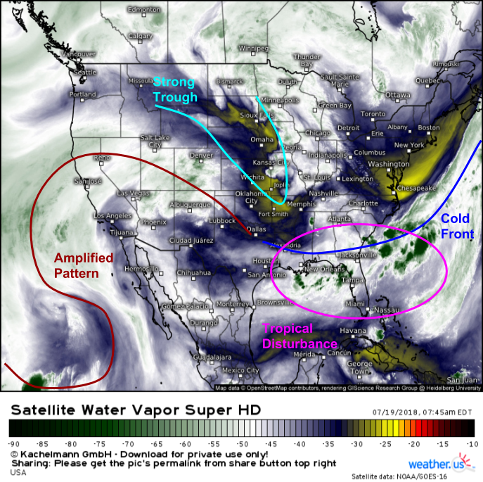
A look at this morning’s GOES-East Water Vapor satellite image shows many of the features that will play a part in the upcoming pattern change. A strong trough is dropping south through the Plains, and a tropical disturbance is festering over the warm waters near Florida. That tropical disturbance is located along a cold front that has stalled off the East Coast. The front will shift back towards the coastline as the Bermuda-Azores high strengthens this weekend. As the trough continues to drop southeast, it will scoop up the tropical disturbance, pulling it and all its moisture northward. The amplified pattern can be seen already emerging over the Desert Southwest and adjacent parts of the Eastern Pacific. That amplified pattern will help lock the moisture and front in place along the East Coast not just for this weekend, but for much of the week ahead and possibly beyond.
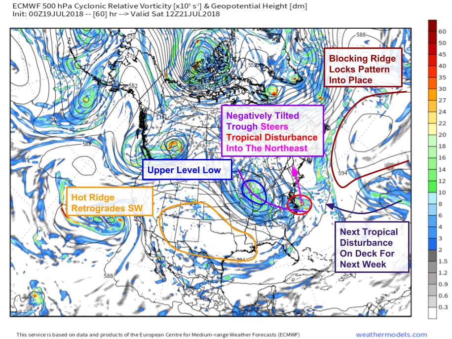
Here’s a look at the ECMWF’s forecast upper air pattern for Saturday morning, when all the pieces will be coming together for the opening round of heavy rain associated with the first tropical disturbance. The upper air map looks more like something we’d be discussing in January than July. A ridge is building across the Rockies, with a large and negatively tilted (NW-SE) trough stretching from the Great Lakes to the Carolina coast. That negatively tilted trough will pick up the tropical disturbance, swinging it north up the coast. It’s the exact same process that steers Nor’easters in the wintertime. This disturbance won’t go out to sea like Nor’easters sometimes do because of that negatively tilted trough, and a strong blocking Bermuda-Azores high to the East (dark red). Another tropical disturbance sliding around on the south side of that high will bring more rain next week. Map via weathermodels.com.
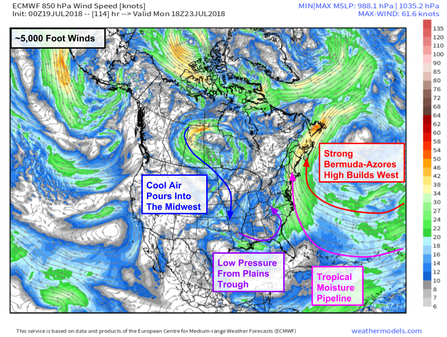
So what do all those upper level features look like a little closer to the surface? Here’s the ECMWF’s forecast low-mid level (~5,000 feet above sea level) wind forecast for Saturday afternoon. The Bermuda-Azores high (along with its namesake islands) is visible in the Atlantic. The low pressure system underneath the upper level trough/low shown above is also visible. Winds blowing clockwise and counterclockwise around these systems, respectively, will create a pipeline of tropical moisture from the Caribbean straight to the Northeast while cool air pours into the Midwest from Canada. Map via weathermodels.com.
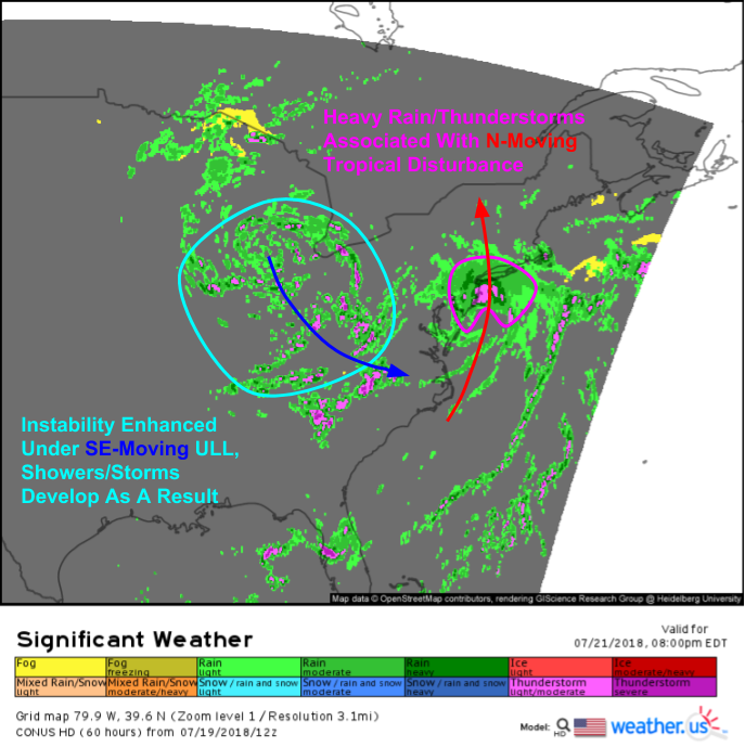
What does that all look like in terms of sensible weather? This overview map from the NAM model gives a pretty good general sense of what to expect for Saturday evening. The tropical disturbance, developed or not, will bring a round of heavy rain and thunderstorms northward as it pinwheels around the eastern side of the upper level low located between Chicago and Detroit. That upper level low will be producing showers and storms of its own accord across the Ohio Valley as cooler temps aloft help increase instability.
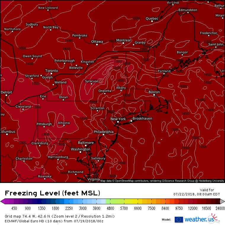
Heavy rain will certainly be the main impact associated with this system, and this map highlights part of the reason why. The parameter shown is the freezing level, which is how far up into the atmosphere you have to go for the temperature to be 32F. Freezing levels will be quite high, rising above 15,000 feet in the core of the disturbance. This makes sense given the tropical origins of the airmass. So why is this important for heavy rain? Raindrops are produced more efficiently when cloud temperatures are above freezing, which results in more water making it to the surface. If you’ve ever noticed that in summer or tropical rainstorms the raindrops are often quite small compared to the raindrops that fall in colder season showers, that difference is due to the cloud temperature. Smaller raindrops form in warmer clouds, and are thus indicative of “tropical rain”.
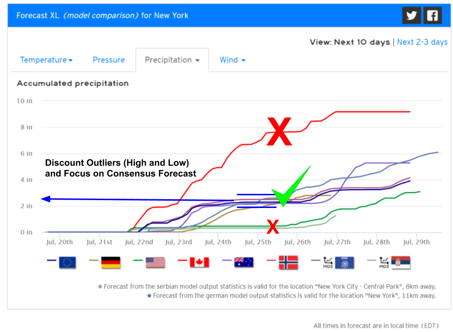
So how much rain can be expected? Our Forecast XL product for New York City is a great example of how to use Forecast XL to answer that question. The graph displays all the computer model forecasts available for New York (any town in the world is available via the search box). Notice that there’s a range of possible outcomes, from the Canadian model’s nearly 8″ forecast to the American model’s paltry half inch forecast. However, most of the available guidance is clustered a little above 2″. Because we can compare the model forecasts all on one graph, we can discount the high and low outliers (though NYC is MUCH more likely to get .5″ than 8″), and be reasonably confident in a forecast of a little more than 2″ through the early part of next week. Amounts will be highest near and just west of the center of the disturbance, with lighter amounts farther east.
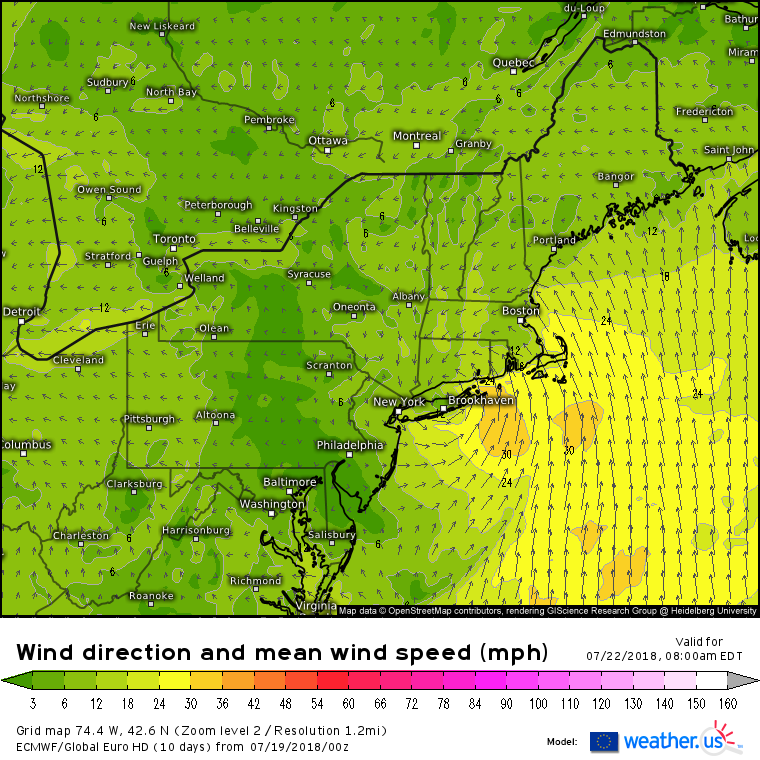
Heavy rain will be the primary concern with the tropical disturbance, but it will also bring a period of breezy conditions to the Southern coastlines of New York and New England. Large scale surface wind forecasts from the ECMWF model aren’t particularly impressive, maxing out around 30 mph at the surface. However, winds over hurricane force lurk a few thousand feet up in the atmosphere. While these winds won’t mix down to the surface in their entirety, thunderstorms that generate lots of vertical turbulence will be able to transfer some of that momentum down to the surface. Based on that, isolated gusts to 50 mph are possible with those thunderstorms, which would be enough to cause scattered power outages.
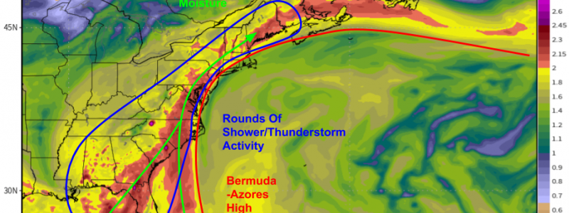
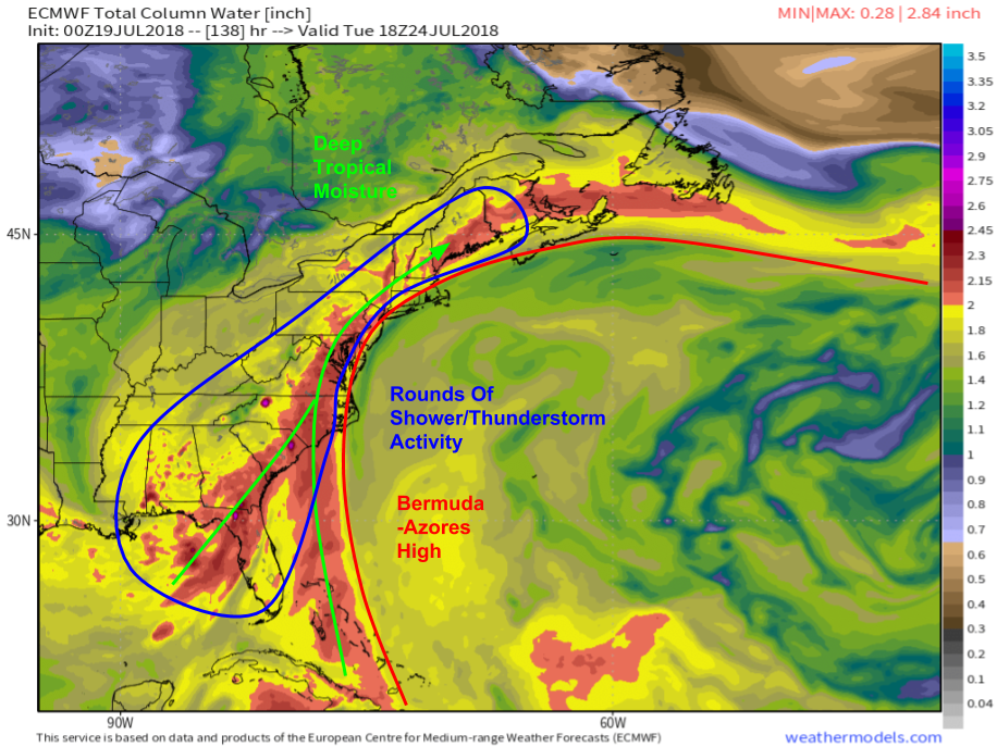
After the first disturbance dissipates over Upstate New York, the humid and unsettled pattern will continue across the East. This precipitable water (moisture) map from the ECMWF shows deep tropical moisture (PWAT values >2″) remaining well-entrenched from Florida to Maine next week. In this moisture plume, rounds of shower/thunderstorm activity can be expected each afternoon, with locally heavy rainfall being the primary impact. Once we get a little closer, we’ll be able to watch for any disturbances that might come along and provide opportunities for more widespread heavy rain, but for now it looks like most precipitation will be of the scattered/daytime heating driven type. Map via weathermodels.com.
Looking even farther beyond, into the 6-10 day range, it appears as though there’s no rest for the weary as far as East Coast humidity goes. The strong Bermuda high looks to stick around into early August, with moisture drawn north between it and low pressure across the Midwest. While day to day conditions will depend on the exact placement of individual fronts, it appears as though the dog days of summer are here to stay for a while. Enjoy it if you can. Map via weathermodels.com.
-Jack


Jack,
I enjoy reading your posts! Will send this to my AC repairman and hope he can finish the job ASAP! Will there be any breaks from humidity in eastern MA next week?