Cristobal Weakens Over Northern Guatemala, Likely To Arrive In Louisiana On Sunday As A Broad Tropical Storm
Hello everyone!
Cristobal has been downgraded to a tropical depression today having lost its 40 mph sustained winds along with most of its thunderstorm activity after it moved inland yesterday. The system is expected to continue weakening for the next 18-24 hours before it re-emerges back over the open waters of the Gulf of Mexico. Exactly when and where that re-emergence occurs will significantly impact the storm’s eventual strength upon landfall in Louisiana (or far eastern Texas) on Sunday night.
If you looked at this satellite loop and thought the storm was centered over the Central Yucatan Peninsula, you’re not alone. That’s where most of the system’s thunderstorm activity is located. The center is actually located near the northwestern corner of Guatemala where very little in the way of thunderstorm activity is currently being observed. This is just one of the many indications that Cristobal is currently quite weak.
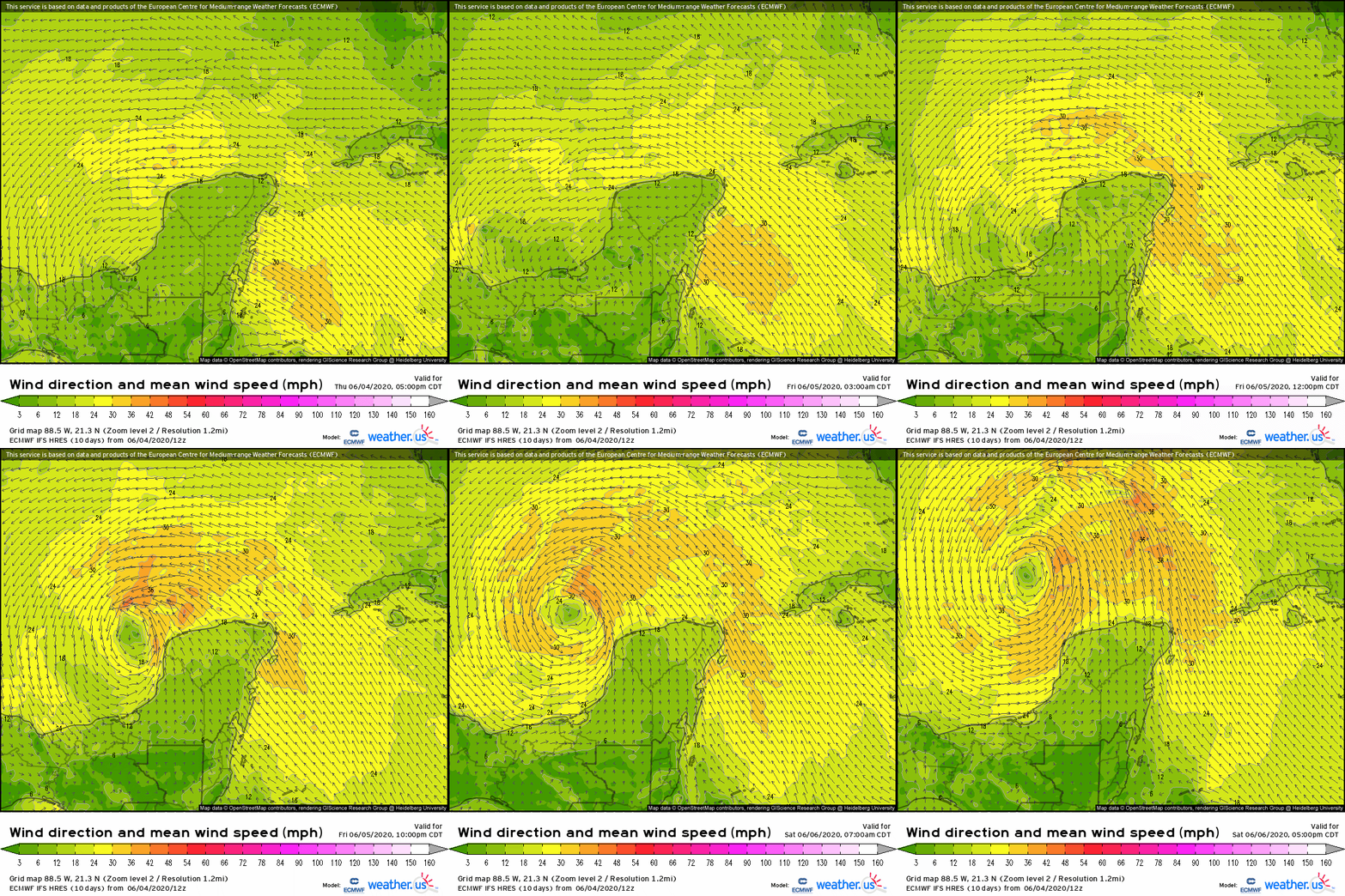
 Cristobal will drift/wobble slowly north over the next 18-24 hours. The ECMWF 10m wind animation shown above highlights this gradual process which really gets going tomorrow morning. By Saturday, the system will be fully over the Gulf of Mexico. However, note the structure of the storm. Instead of a compact circulation with a narrow corridor of intense winds near the center, we’ll be looking at a broad system with a very wide expanse of breezy conditions and relatively “weak” winds near the center. I put weak in quotations because there’s still a chance that the system could consolidate enough to develop a narrow core of 60+ mph winds that could cause damage when the system makes landfall. However, a system that brings 60 mph winds to a narrow swath of the coastline will probably end up causing less disruption than a system that only has maximum winds of 50 mph but brings 40+ mph winds to a very large area. While there was some initial uncertainty regarding which type of system Cristobal would end up being, it’s now quite clear that the system will be of the broader variety.
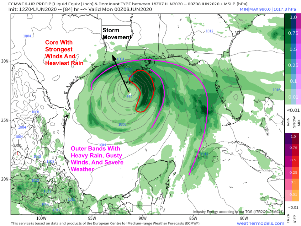
 The wide expanse of Cristobal’s impacts shows up well on this ECMWF forecast map valid Sunday evening. The storm center will be south of the central Louisiana coastline, but rain and wind associated with the system will stretch from Cuba to Houston. The system’s outer bands won’t be strong enough to cause widespread damage, but they will pack a punch, especially as you get closer to the center. These outer bands, composed of lines of strong thunderstorms, will bring wind gusts over 60 mph (severe thunderstorm winds), heavy rain, and the chance for waterspouts/tornadoes. So even if you’re several hundred miles east of the center (looking at you, western Florida!), you will still be impacted by Cristobal. The core of the storm is where the strongest winds and heaviest rain are located. Cristobal’s core, having dissipated today, will not be compact and intense like most hurricanes. It, like the rest of the storm, will be a bit more spread out. SW winds in the upper atmosphere will push most of the core thunderstorms northeast of the center, so areas east of the landfall point will experience more impacts than areas west of the landfall point.
Currently, it looks like Cristobal will make landfall as a moderate-strength tropical storm with maximum sustained winds somewhere around 50-60 mph. That could end up changing if the system struggles more than anticipated during its reorganization process, or if the environment over the Gulf ends up being just favorable enough for a bit more intensification.
Click here to learn more about ensembles and why they’re so useful in situations like this.
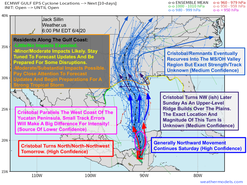
Today’s version of the annotated spaghetti map doesn’t look all that different from yesterday. We have the basic idea of Cristobal’s forecast pretty nailed down at this point. It will drift north (more or less) for the next several days, slowly intensifying as it does so after it emerges back over the Gulf tomorrow afternoon/evening. The system will then make a (probably subtle) turn to the northwest as it’s approaching the Gulf Coast, likely with maximum winds of 50-60 mph. By Monday/Tuesday, the storm will transition into an extratropical cyclone as it recurves into the MS/OH Valley region. Power outages from gusty winds and flooding issues from heavy rain will continue well inland, so make sure you’re prepared even if you don’t live right along the coast!
I’ll have another update tomorrow and/or Saturday as the system’s final landfall intensity (hopefully) becomes a bit clearer.
-Jack


