Cold Front Brings Rain, Gusty Winds, And Falling Temps To The East While Fire Weather Becomes Critical In Southern California
Hello everyone!
After a month of quiet weather, we have a lot to discuss this morning due to a strong storm system moving out of the Great Lakes region. This system has ushered in a large-scale pattern change that will impact everyone from coast to coast. In the East, the front will bring rain showers, gusty winds, and falling temperatures from New England to the Gulf Coast. Some winds in Maine could be strong enough for power outages, while thunderstorms may accompany the front in Texas. Behind the front, cold air is surging in over the warm waters of the Great Lakes. This means that we’ll look for Lake Effect snows to begin today as that cold air moves east. As a result of this system’s development, high pressure is building in across the Rockies. This high pressure is fueling Santa Ana winds that will cause critical fire weather conditions in parts of Southern California. What a day!
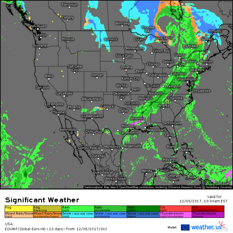
The ECMWF’s overview map for today highlights our cold front as the dominant purveyor of precipitation this morning. It will bring a steady, moderate rainfall to everyone along and east of the Appalachians today. The tail end of the front, located across parts of Louisiana and Texas will feature some thunderstorms with spottier, locally heavier rainfall.
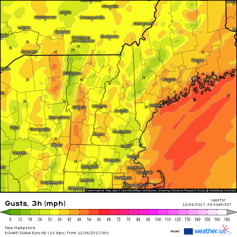
The biggest issue associated with the northern part of the front today will be gusty winds and the potential for power outages from Cape Cod to the Maine coast. SSE winds will increase as the front approaches today, and gusts are likely to fall in the 50-60 mph range for a time early tomorrow morning. As we saw with the storm just before Halloween, this area is especially vulnerable to power outages from winds that have an easterly component. While this storm won’t be anywhere near as bad as the one on 10/30, do be prepared for scattered outages late tonight and early tomorrow morning. Winds will shift to the westerly direction and calm down a bit after the front passes tomorrow morning.
The middle part of the front, from New York to Georgia, will feature minimal impacts as a line of showers moves through. Winds behind the front will be breezy, and may gust to 30 mph at times, but no major problems are expected.
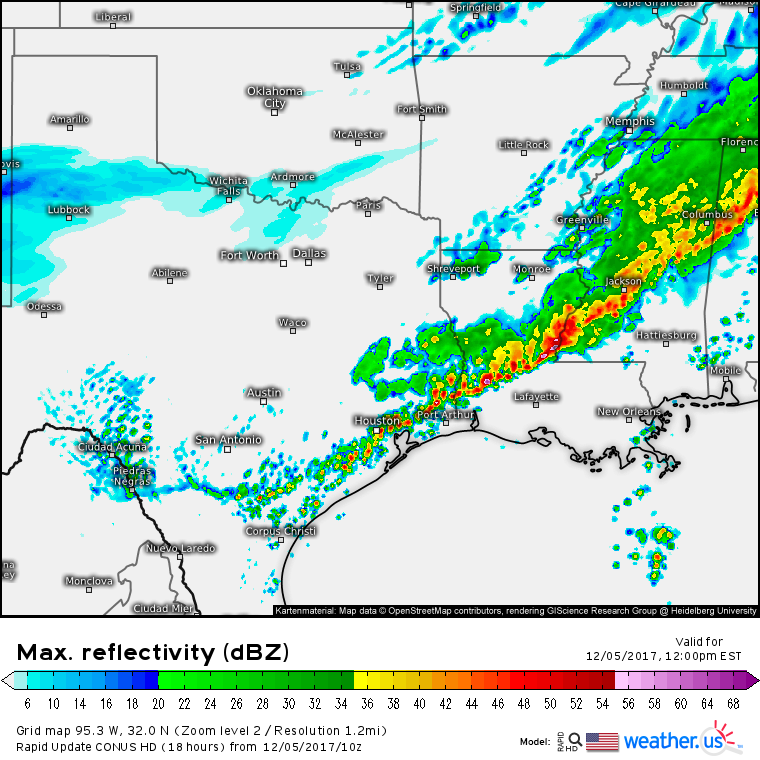
The southern part of the front will extend from Mississippi through Louisiana and into Texas. Due to this area’s proximity to warm, humid air from the Gulf of Mexico, thunderstorms are expected to develop this morning as daytime heating gets underway. Due to a lack of upper level support, these storms are not expected to bring widespread severe weather, but a few strong wind gusts could accompany heavy rain and lightning, which will be the main threats. Storms will move offshore this afternoon as the front passes through.
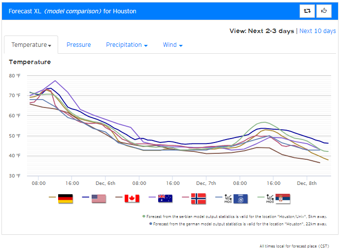
The front will be accompanied by an unusually steep drop in temperatures across Texas and Louisiana. Our Forecast XL product for Houston (for more on Forecast XL) shows temps in the 70’s this morning that rapidly fall into the low 40’s by tomorrow morning as the front moves through. This frontal passage and temperature drop will be accompanied by gusty winds, though widespread problems are not expected.
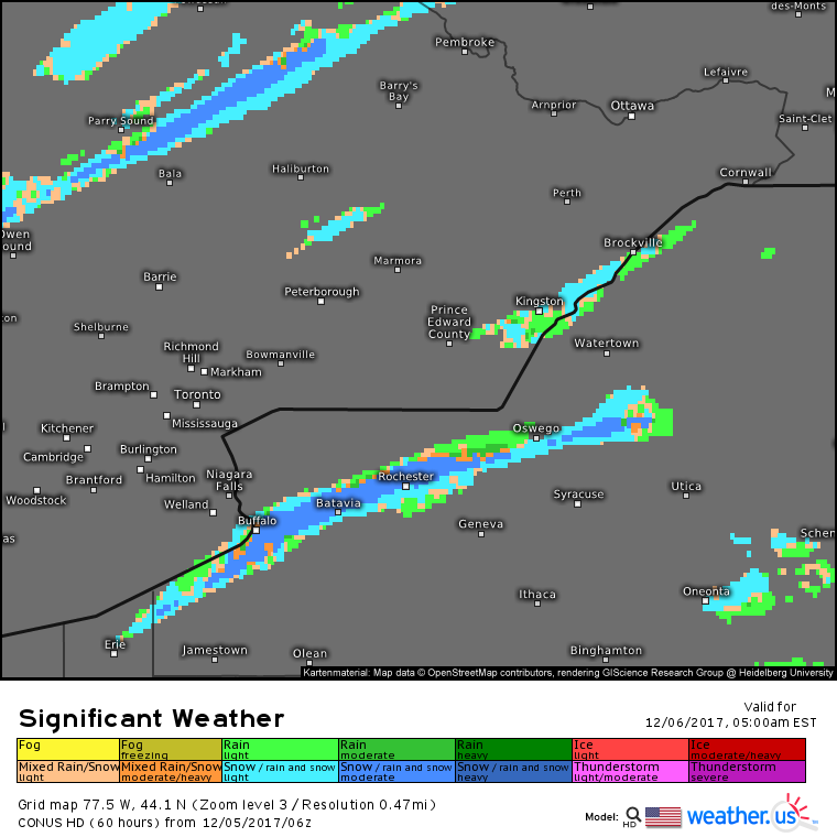
Speaking of temperature drops, cold air will also be moving into the Great Lakes behind the front, which has already passed through the area. Look for lake effect snow to develop as this cold air makes eastward progress today. Initially, this cold air will be moving in on SW winds which will push most of the snow bands into Canada, though some off of Lake Michigan could impact the lower peninsula.
As the cold air hits Lake Erie, a lake oriented WSW to ENE, the WSW winds will become a boost to lake effect banding which will set up likely just south of Buffalo by tomorrow morning. Because the wind is blowing down the length of the lake, expect a single, very heavy band to set up as opposed to many lighter bands. Under this band, expect low visibility in heavy falling and drifting snow. Snow totals near two feet are possible as this band will stick around for quite a while. However, these high totals will be very localized, as is common with lake effect setups. One town may see two feet while adjacent areas pick up a few inches at best.
The middle of the country will see quiet weather as NW breezes bring cool and dry air southeastward. Out west however, not all will be quiet, despite the presence of high pressure.
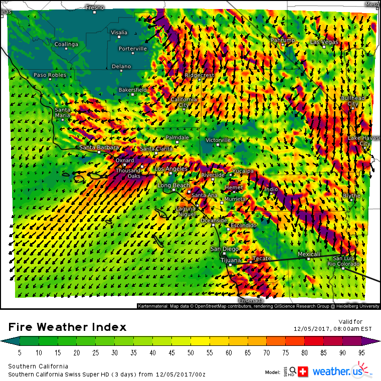
The Swiss Super HD model’s fire weather index forecast shows values approaching 100 in several parts of Southern California this morning. High pressure and cold air is locked in place over the Great Basin, and this dense, cold air is trying to escape through the coastal mountain ranges near LA. As it pours through these passes, it accelerates, warms, and dries. These hot downsloping winds are known as Santa Ana winds, and they create the ideal conditions for rapid fire spread. Several fires are already causing problems, and with winds expected to continue this morning, look for those issues to continue.
For more information about your local forecast: https://weather.us/
For more information about the local forecast for Maine and New Hampshire: https://forecasterjack.com/2017/12/05/rain-arrives-today-2/
-Jack
