Coastal Storm To Bring Raw Weather To New England Today
Hello everyone!
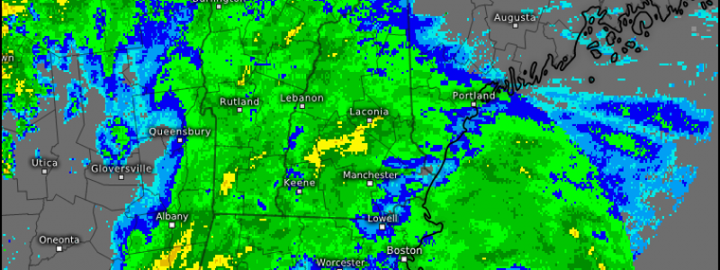
Today’s weather will be dominated by a feature we would hardly blink at in December, but is notable in July- a weak storm developing off the coast of New England. While it’s not exactly one of the behemoth storms that roar up the coast in January, it will bring an unusually cool and raw day to much of New England and parts of New York as well. Heavy rainfall associated with the storm could also bring flooding concerns and the back end of the storm could feature severe weather this evening. All in all, it’s a pretty active day for July!
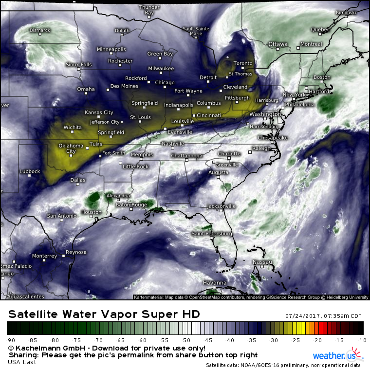
Water vapor imagery from GOES-16 shows the setup quite well. An upper level low is located just west of Toronto. Strong energy is driving east to the south of this low and is entering Western Pennsylvania. A deep plume of tropical moisture is surging north from the Gulf of Mexico and is feeding into the storm. All the ingredients are present for this event to unfold, and it is unfolding quite nicely. Bands of heavy rain are developing across New England and they will continue to do so through this afternoon and evening.
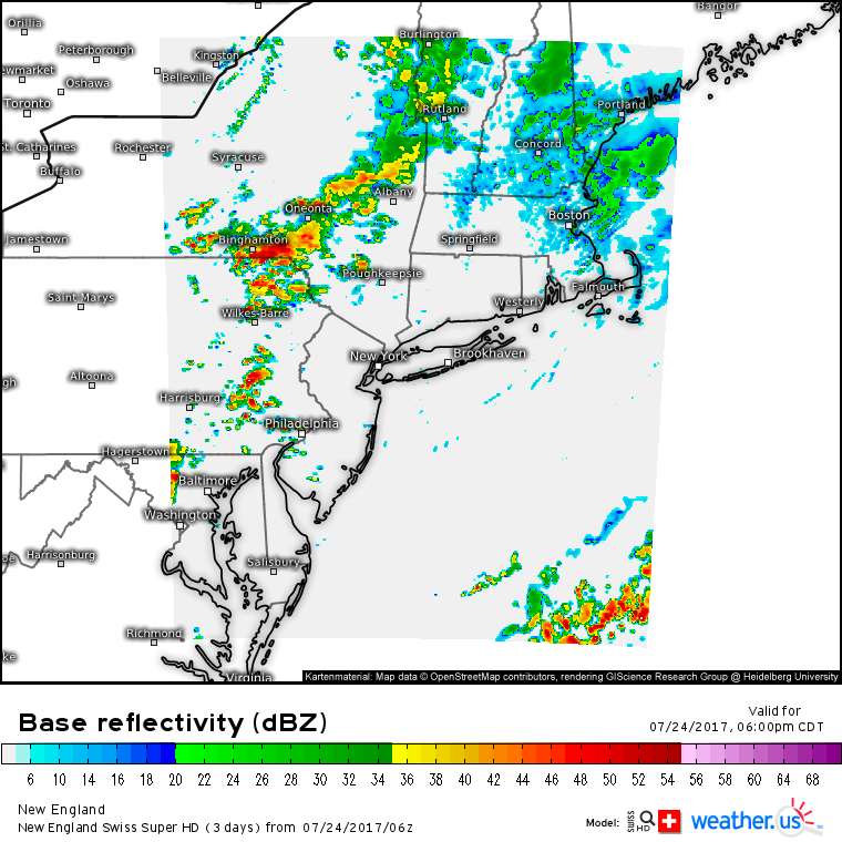
These rain bands are being driven by dynamics we typically reserve for winter storms. Warm air is being transported in from the south and is being forced to rise up and over low level cold air. This forcing, known as isentropic lifting, is typically confined to the cold season when there’s plenty of low level cold air to go around. In the summertime, the low levels are typically quite warm and thus much of our precipitation is driven by convection (thunderstorms). That’s part of the reason why this system is so noteworthy and unusual. Note the curved bands over SE NY that extend into W MA and S VT/NH. Those look a lot like heavy snow bands, and they’re driven by many of the same processes!
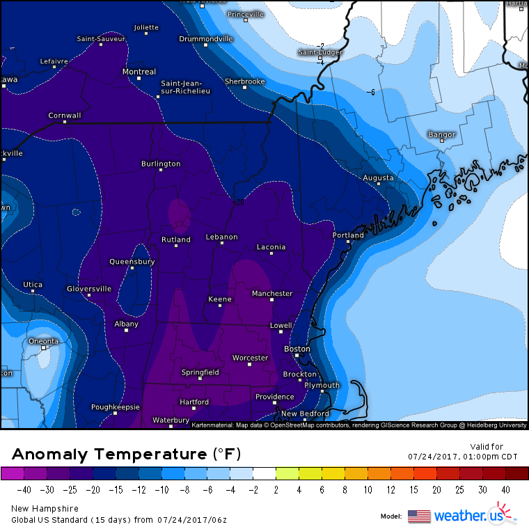
Speaking of low level cold air, high temps today are forecast to be 20-30 degrees below normal for New England. That’s part of why this system is so unusual!
So what’s ahead for this storm? There are actually two parts. The coastal low, and the trailing low/cold front. The coastal low will move east-northeast towards Nova Scotia and the steadier rain will move into parts of NE MA, NH, and ME. Meanwhile, the trailing low/cold front will drop SE through NY. As it does, some strong to potentially severe thunderstorms are expected to develop. The reason for this can be seen in the water vapor satellite image above. Note the area of dry air (yellows/oranges) over the NE Ohio Valley. This dry air is already resulting in clearing skies across Pennsylvania and SW NY.
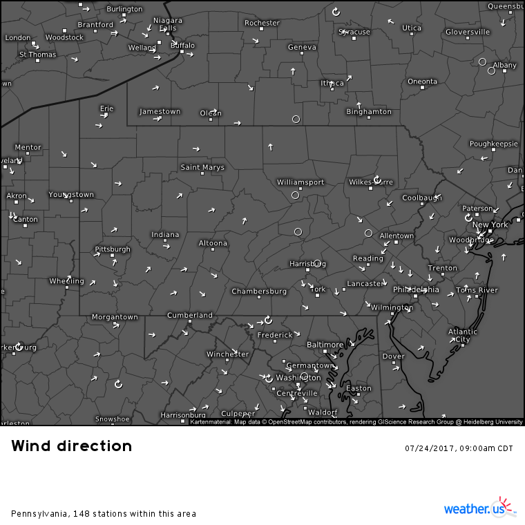
As additional upper level energy drops in from the upper level low (visible on the WV satellite), storms will fire this afternoon just East of the Great Lakes and they will move ESE through the evening. Some slight weakening is expected as the storms near the shore and move into the stable marine layer that has been left by the departing coastal low. Current observations show a sharp temperature gradient across this boundary, located in NNJ and NE PA. The boundary shows up even better with current wind observations.
On the NE side of this boundary, cool and stable marine air will be present. On the SW side, warm and unstable air will be present. As storms approach and cross this boundary, they will fade as their fuel is rapidly depleted. However, if any storm can manage to latch onto the boundary, straddling both the warm and cold sides, the energy associated with the front could produce a brief tornado or two. This isn’t expected to be likely or widespread, however it can’t be ruled out. Be sure to watch the radar closely if you live in these areas to see if a dangerous storm could be headed your way!
Despite the tornado threat being limited, damaging winds and large hail are a threat with any and all storms that develop.
More widely scattered showers and storms are forecast across parts of the Northern Plains and the Deep South. For more information on the forecast for your location, head on over to weather.us!
-Jack Sillin
