Backdoor Cold Front Bringing A Big Cooldown to New England
Hello everyone!
After several days baking under 90 degree heat, New England and adjacent parts of the northern Mid Atlantic will enjoy a dramatic cooldown today and tomorrow. Ahead of the front, severe storms are in progress across parts of Connecticut, SW Massachusetts, and SE New York. I’m going to talk a little bit about the severe weather setup for the rest of the afternoon and this evening as well as how long the cooldown is expected to last.
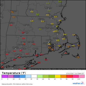
Here’s a look at the temperatures across Southern New England this afternoon. As you can see, a very strong gradient is present with temps near or over 90 degrees in CT/SW MA while areas less than 50 miles NE are sitting below 60 degrees. The front is moving southwest which is unusual because cold fronts typically move east or southeast in the prevailing westerly flow. The unusual SW movement of this front is what gives it the “backdoor” name.
So what’s driving those cold temps in NE MA, NH, and ME? The Gulf of Maine currently sits a little above 60 degrees in terms of water temperature and it’s not a coincidence that temps on the NE side of the front are right around that mark. Winds are out of the NE in those locations, right off the Gulf of Maine. The cool maritime air is also accompanied by drizzle, low clouds, and patchy fog for many areas. The abundance of clouds present NE of the front is also helping to contribute to the cool temps by blocking radiation coming in from the sun.
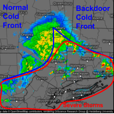
Very hot and humid air is located to the south of the backdoor cold front and the remnants of a Mesoscale Convective System form the western boundary of this very warm airmass. As the backdoor cold front moves SW and the normal cold front/MCS remnants move east, this warm and unstable airmass is being forced to rise. As it rises, it cools and condenses and as a result, thunderstorms are widespread across the region. Severe thunderstorm watches are out for the area highlighted in red as well as parts of NJ and PA that are not shown here.
The biggest threat from these storms will be damaging winds as the airmass is too warm to support widespread hail and winds aloft are not supportive of tornadic activity.
Storms will continue to develop and move east/southeast through this evening. Follow them as they do so over at weather.us’s radar page. In addition to the severe weather threat, flash flooding could be an issue given the high amount of moisture in the air this afternoon and evening. Up to 3″ of rain could fall across parts of SE NY, SW MA, CT, and RI. If you see flooded roadways, be sure not to drive through them!
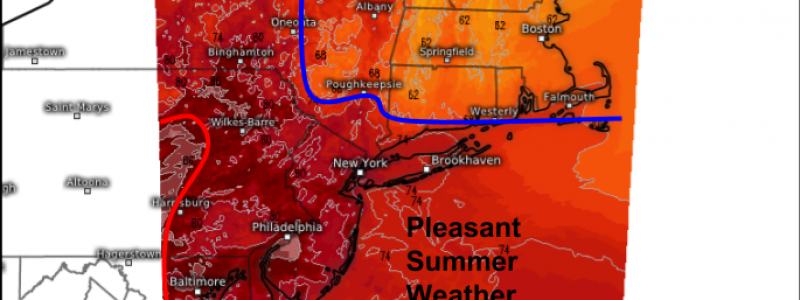
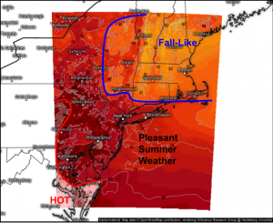
So how long does the relief last? Fall like temps stick around through tomorrow in New England and a respite from the brutal heat is in the works for the northern Mid Atlantic as well. By the time the weekend arrives, though, temps will slowly be creeping back up as another cold front approaches from the west.
High temperatures tomorrow afternoon will be 10-15 degrees below normal for much of Southern New England in the “fall like” zone. Unusually cool temps will also be present in New Jersey though highs near 80 aren’t exactly cold. South of the front across parts of the Southern Mid Atlantic, temps 5-10 degrees above normal will continue to feel quite uncomfortable and there is little relief in sight.
For more details on what the weather is doing at your house, check out the wide variety of forecast tools at weather.us!
-Jack


