Atmospheric River To Bring Heavy Rain To Parts Of California Today
Hello everyone!
Today will feature the beginning of an Atmospheric River event in California as low pressure well offshore pushes a deep plume of tropical moisture towards the state. The tropical source of the airmass, combined with the climatological pressures of April and ridging aloft will result in this being a mainly rain event outside of only the very highest Sierra summits. Rains will be heavy at times today as the warm airmass allows for efficient raindrop production. Flash flooding and mudslides will be concerns today for those who end up under the heaviest bands.
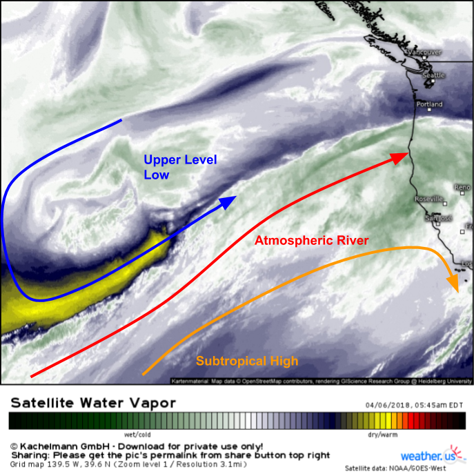
Water Vapor satellite imagery (what’s that?) is a valuable tool to visualize setups like this. This morning, we can see an upper level low well west of California, and a subtropical ridge of high pressure to the southwest of the state. Between the low and the high, strong winds out of the southwest are present. These winds are responsible for transporting moisture from Hawaii all the way to the West Coast.
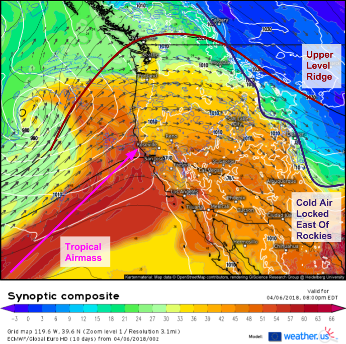
Snow levels with this storm will be extremely high, around 12,000 feet. The ECMWF’s synoptic composite map (what’s that?) above explains why. In addition to the influx of tropical air from the southwest, upper level ridging is also present in the area. This ridging favors warmer temperatures, which can be verified by looking at the shaded layer (theta-e, a measure of heat/moisture) which shows any cold air locked in place east of the Rockies, and no available cold air taps in sight for the West Coast.
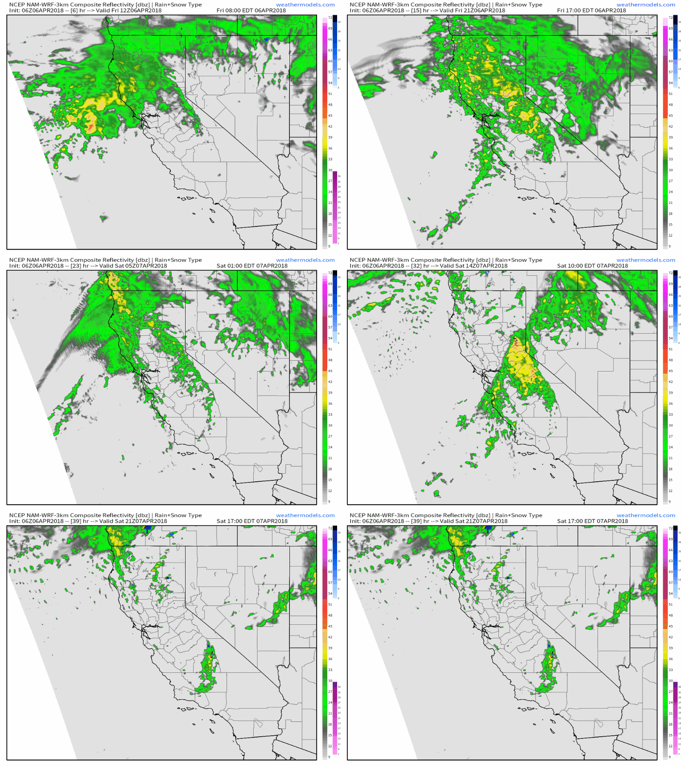
Here’s a general look at how the event is expected to evolve between this morning and tomorrow evening. As always, the heaviest percip will be on the SW slopes of the higher terrain, though as the storm pushes a cold front closer to the region, lower elevations will get in on the action as well. That cold front will also bring in enough cool air right as precipitation is ending to drop snow lines a bit over the Sierras and allow for some modest accumulations near some of the passes. GIF via weathermodels.com.
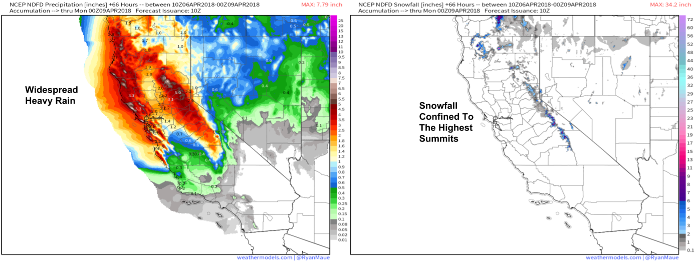
Here’s the NWS’s forecast for total precipitation and snowfall between now and the end of the weekend. Notice the widespread heavy rainfall with 3-5″ amounts common north of the Bay Area. Also notice the snowfall forecast and the very limited scope of accumulations due to the warm nature of the system. Above 12,000 feet where it does snow though, there will be plenty of accumulation to be had. Maps via weathermodels.com.
Rain and snow will taper off over the weekend as the system moves inland.
For more information on your forecast: https://weather.us/
For more information on the local forecast for ME/NH: https://forecasterjack.com/2018/04/06/pleasant-this-morning-burst-of-heavy-snow-arrives-this-afternoon/
-Jack


