Arctic Cold Front To Bring Snow To Parts Of The South Tuesday
Hello everyone!
On Friday, I discussed the blast of Arctic air set to invade the Midwest this coming week. That forecast is still quite valid this afternoon, though the cold air certainly isn’t limited to the northern half of the country. Cold air will also spill into the Southeastern states behind the same cold front that ushers in the below-zero temps up north. The precip associated with that front is likely to end as snow for a good part of the Southeast from Missisippi to Georgia. This post will discuss the forecast for that system as well as some of the dynamics fueling it.
Here’s a look at the general setup heading into the event on Monday night. The storm out ahead of the upper level low will be located over Michigan, with its cold front sagging south into Texas. The airmass behind that front is key because it’s coming right from the Canadian Arctic, and will be travelling over fresh snowpack left by that storm in Michigan. The airmass will also be moving quickly, meaning it won’t have much time to “modify” i.e. get less cold after it moves out of the Arctic. Map via weathermodels.com.
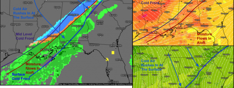
As the front approaches the Southeast, it will pick up some moisture from the Gulf of Mexico which will result in more widespread precip breaking out from Louisiana up into the Southern Appalachians. The maps on the right show windflows at the surface (bottom) and 10,000 feet (top). Notice that the cold front is located much farther east than the front aloft. This is what enables the change over to snow, because the Gulf moisture is still flowing in aloft which keeps the precip going, while the northerly winds at the surface bring the cold air in from the north. Of course, the more northerly parts of Mississippi, Alabama, and Georgia will see that transition occur earlier, with the surface cold air deep enough to result in accumulation as opposed to just conversational flakes.
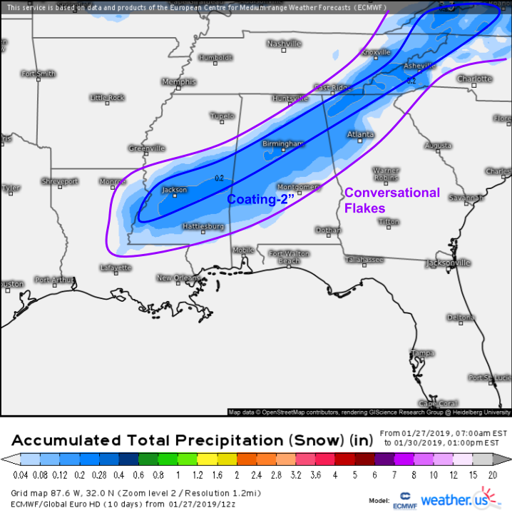
Here’s a look at how much snow might fall from this system. Note that this is the liquid equivalent that might fall as snow, as opposed to the actual snow accumulation. Most areas will just see some “conversational flakes” that are enough to talk about, but not enough to accumulate. A narrow swath from Jackson MS up through Birmingham AL into NW GA could see as much as 1-2″ as a wave of low pressure rides along the front, prolonging the precip as the cold rushes in. Watch out for very slick roads here on Tuesday! Precip will end as the dry air moves on aloft later on Tuesday.
-Jack


