Another Generally Warm Day With Weak Systems Today. What’s Behind The Lull In Winter?
Hello everyone!
Today will feature yet another day of generally warm weather across the US, along with generally weak storm systems that won’t bring much in the way of impactful weather. We’ll have some snow in parts of the Rockies, but it will generally be focused in the higher elevations. Showers in the Ohio and Lower Mississippi valleys will be weak, disorganized, and also of low-impact.
Here’s the ECMWF’s overview map showing our bland weather today. For more information on what to expect in your area, please head on over to weather.us to zoom into this map, or use our point forecast tools such as Forecast Essentials (quick look) or Forecast Ensemble (more detail). Unsure how to use these or other products on our sites? Check out the tutorial videos section of the blog, and if there’s not a video up yet to answer your questions, leave a note in the comments and I’ll be happy to explain.
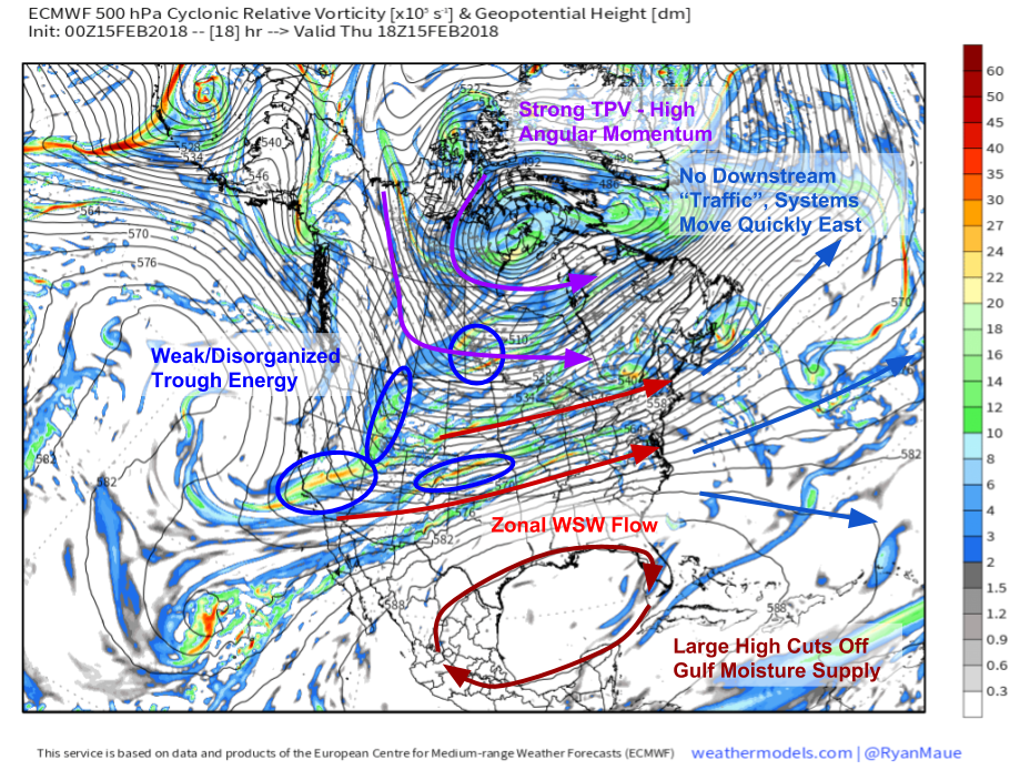
So what’s behind our stretch of April-like weather here in the middle of February? The mid level vorticity (energy) map from weathermodels.com below explains. Notice there are two dominant features on this map, an intense low pressure (low geopotential heights, shown with black contours) system over NW Hudson Bay, and a sprawling high pressure (high geopotential heights) system in the Gulf of Mexico. The strength of these systems, as well as their close proximity, means that there’s a lot of what’s called angular momentum over the US. High angular momentum means that air parcels moving over the US have a lot of west-east energy (momentum), and because it’s hard to change the course of anything with a lot of momentum, there’s not much opportunity for meridional (N-S or vice versa) flow.
What does all that mean for us? The high angular momentum is driving three processes that are resulting in warm weather, and inhibiting the development of impacful storm systems. First, trough energy over the West can’t organize into one coherent system. The northern disturbances can’t dive south, and the southern disturbances can’t lift north. They all have too much angular momentum, and as a result, stay separate from each other as they move east. The high angular momentum is also blocking any Arctic or Polar air from diving south out of Canada. As a result, we have a general WSW flow regime over the US which is bringing warm air from the Desert Southwest through the Plains and towards the East. While some moisture is getting caught up in this flow from the Pacific, the large high over the Gulf of Mexico is preventing any deep moisture taps from that region, so there’s very limited moisture for any of those weak disturbances to work with. Finally, the zonal flow continues over the Western Atlantic, where there’s no blocking (aka “traffic”) to stop or even slow down disturbances as they race east. If there was some traffic there, we could see disturbances start to congeal a bit and form into larger storms, but without it, we’re left mostly in the dry.
No major changes are expected in this pattern over the next few days, but just enough downstream traffic may develop by this weekend to allow for some snow in parts of the Northeast. More on that to come.
For more information on your local forecast: https://weather.us/
For more information on the local forecast for ME/NH: https://forecasterjack.com/2018/02/15/anomalous-warmth-continues/
-Jack


