Anatomy Of A Mid-Latitude Cyclone
Hello everyone!
Mid-latitude cyclones are responsible for the majority of our ‘interesting’ weather here in the US given that we’re far enough north to be mostly out of the tropics (though tropical cyclones do sometimes stray our way) and far enough south to escape the polar regions. The mid latitudes are the battleground between the warm moist air of the tropics and the cold dry air of the far north. The constant push and pull between these forces creates cyclones that can become quite intense. With that in mind, it’s helpful to have a basic blueprint in mind for what a mid-latitude cyclone looks like in the most general sense, and what types of weather can be expected in various locations within the storm’s sphere of influence.
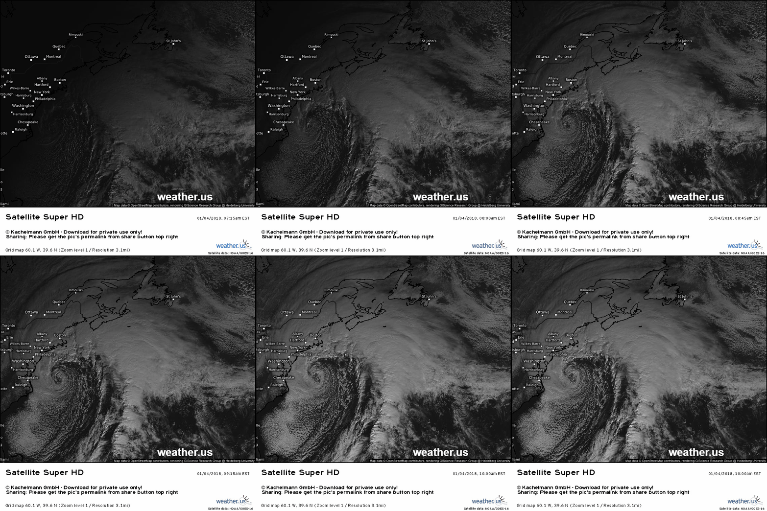
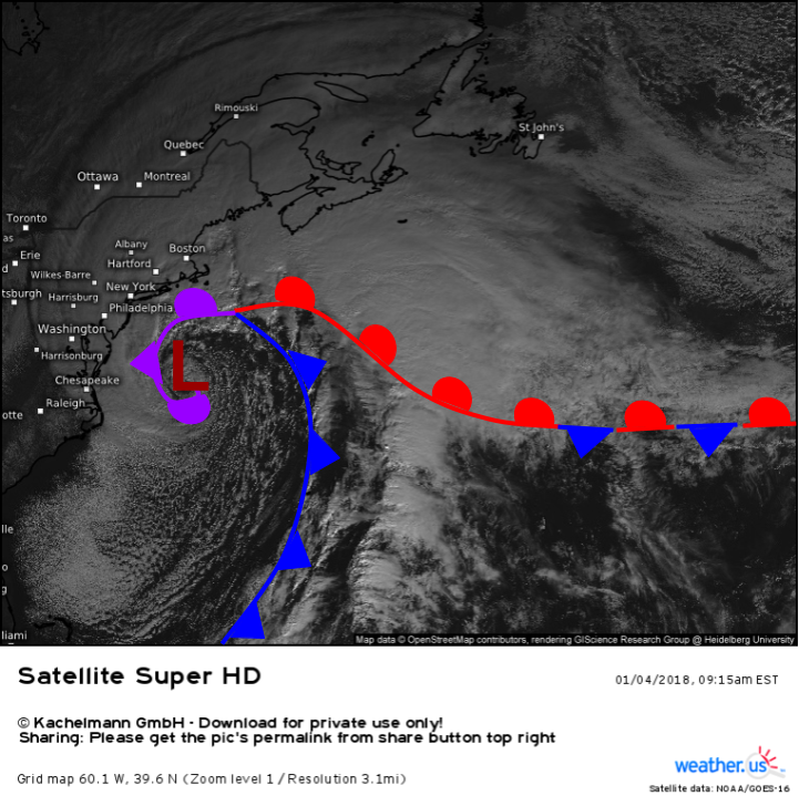
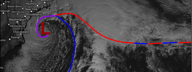
This is the type of cyclone I’m talking about. You can see distinct frontal boundaries where different airmasses meet, and if you follow these boundaries far enough, they spiral into the storm’s center. This particular system brought blizzard conditions and feet of snow from parts of North Carolina all the way up to Maine early in 2018. It also brought a major storm surge and associated coastal flooding to parts of coastal Massachusetts including Boston and Cape Cod. What do I mean by frontal boundaries and where are they in this particular storm? Here’s an annotated still image from 9:15 that morning, about half way through the loop.
A frontal boundary is simply a boundary separating two different airmasses, or large blobs of air with relatively similar temperature/moisture parameters. Frontal boundaries come in four flavors: warm, cold, occluded, and stationary. Each type of front is visible on the image above, and has a unique marking that’s standardized across all weather maps you’ll see. Warm fronts are marked in red and have semicircles on one side. Cold fronts are blue and have triangles on one side. Occluded fronts are purple with alternating triangles and semicircles, while stationary fronts have red and blue semicircles/triangles pointing in opposite directions. The markings on each front (semicircles and triangles) always point in the direction of the front’s motion. Stationary fronts don’t move, hence their name, and have alternating markings as a result.
Because fronts predict in relatively consistent ways, we can draw some general conclusions about the weather in different parts of the cyclone.
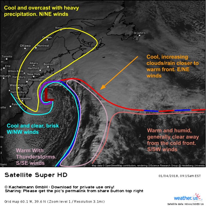
This is the same map as before, except now I’ve highlighted areas of generally consistent weather and their position relative to the fronts. Of course these generalizations won’t always work, especially for cyclones that aren’t as intense as this one, but they’re good rules of thumb in the absence of better information. Temperatures, winds, and sensible weather (rain/sun/snow/etc.) can be generalized from your position relative to a cyclone, but you’ll need more information to draw accurate conclusions about other important forecast parameters such as precipitation type/amounts.
It’s also important to note that not all storms have every type of front. Occluded fronts only form once the cold front catches up to the warm front (it moves about 30% faster), so young storms will only have the warm and cold fronts. Stationary fronts are also not ubiquitous with every storm. Sometimes you’ll get a cold front to become detached from its parent low and slow down until it becomes a stationary front, which then isn’t connected to any cyclone. Sometimes storms only have a warm front as the leading edge of the southward-moving cold air gets muddled and distorted by mountains (this happens often in the lee of the Rockies).
While familiarity with the anatomy of a cyclone isn’t a free pass to flawless forecasting, it’s an important first step in understanding how our weather works.
-Jack
