Active Weather Continues Across The East This Weekend
Hello everyone!
Active weather continues to impact the Eastern third of the country both today and tomorrow as a series of weak low pressure systems move along a frontal boundary. Impacts from this parade of systems will include snow for parts of the Midwest/Great Lakes, ice for parts of the Southern Plains/Ohio Valley, severe storms for parts of the Deep South, and heavy rain for a wide swath of the Southeast/Mid Atlantic. I’ll break down each aspect of the storm below and explain a little bit of the science behind the forecast as well as where you can go on weather.us and weathermodels.com to learn more about what’s headed your way.
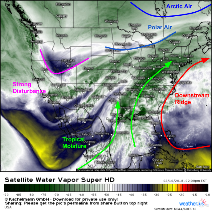
Here’s a look at Water Vapor satellite imagery this afternoon (what’s that?). You can see several key elements on this map that will have implications for the forecast from New Orleans to Boston. First and foremost, take a look at the deep tropical moisture plume from the East Pacific and Gulf of Mexico that stretches all the way up into New England. This sets the stage for some of the impacts I’ll discuss below. Any dynamics that occur in this type of airmass will have an outsize influence on impacts due to the amount of available moisture. This moisture is being pushed north in between a digging trough over the Rockies and a very strong downstream ridge over Bermuda. That downstream ridge is also important because it’s strong enough to dislodge the Arctic air well to the north in Hudson Bay, and keep even the Polar air near the far NW fringes of the Eastern US. However, it doesn’t take deep Arctic cold to cause problems when there’s this much moisture around.
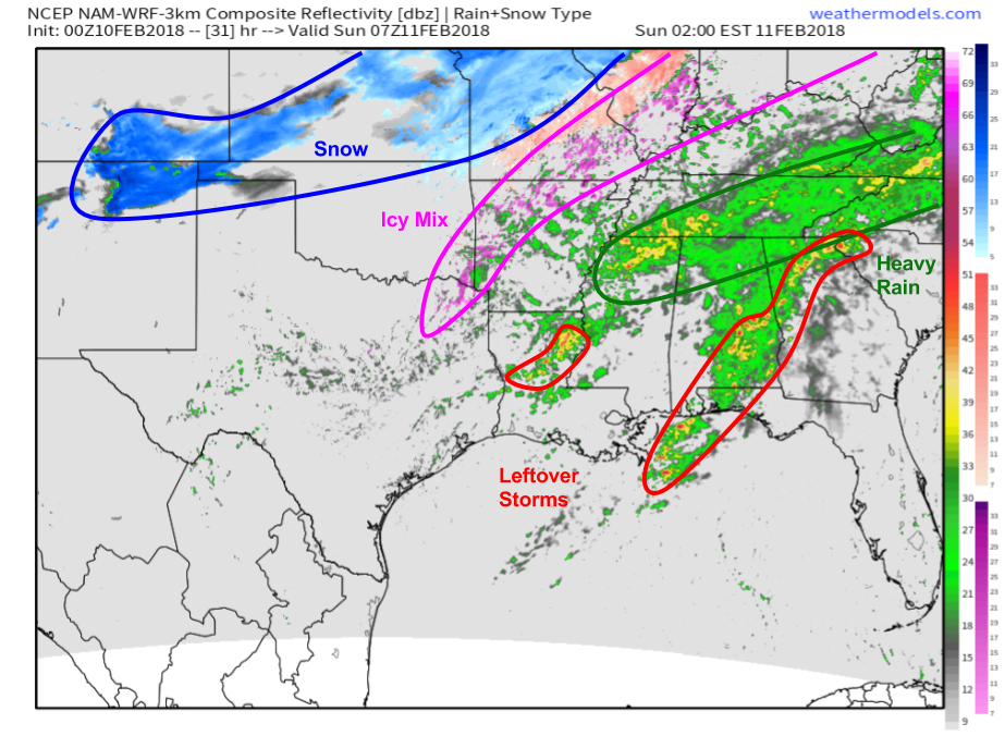
Here’s a look at simulated radar imagery from the NAM model valid at 2 AM tomorrow. Notice that as cold air filters into the NW side of the precipitation shield, we see an area of icy mixed precipitation develop from far NE Texas through parts of Arkansas, Missouri, Illinois, and Indiana. While total ice accretion will remain below 1/4″, and thus won’t result in any power outage concerns, the combination of the ice and potentially some sleet/ice pellets will result in very slick travel conditions in this area tonight and early tomorrow morning. Snow will be found deeper into the incoming cold airmass across NW Missouri, Kansas, and the panhandles of Texas and Oklahoma. Total snow amounts are not expected to be much more than an inch or two, with the exception being the far western edge of the area highlighted above in CO/NM. This area will be closest to the strong upper level disturbance I highlighted earlier, and could see several inches of accumulation.
Map from weathermodels.com.
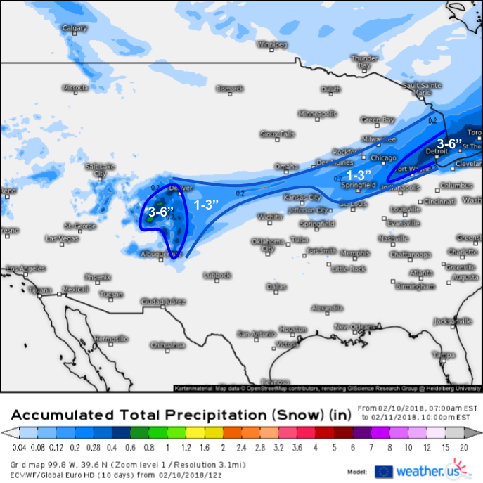
Speaking of snow, here’s a look at how much snow to expect through tomorrow night (how to use this map) as a result of this system.
Impacts from snow from this system will be fairly light due to the downstream ridge keeping the cold air confined to the very NW fringe of the moisture plume. The jackpot areas will be the Rockies between Denver and Albuquerque as well as SE Michigan, as those areas will experience a better overlap of moisture, lift, and cold air. Snow accumulations in the Northeast will be limited to the higher terrain of far NW New England and far northern New York where several inches are expected.
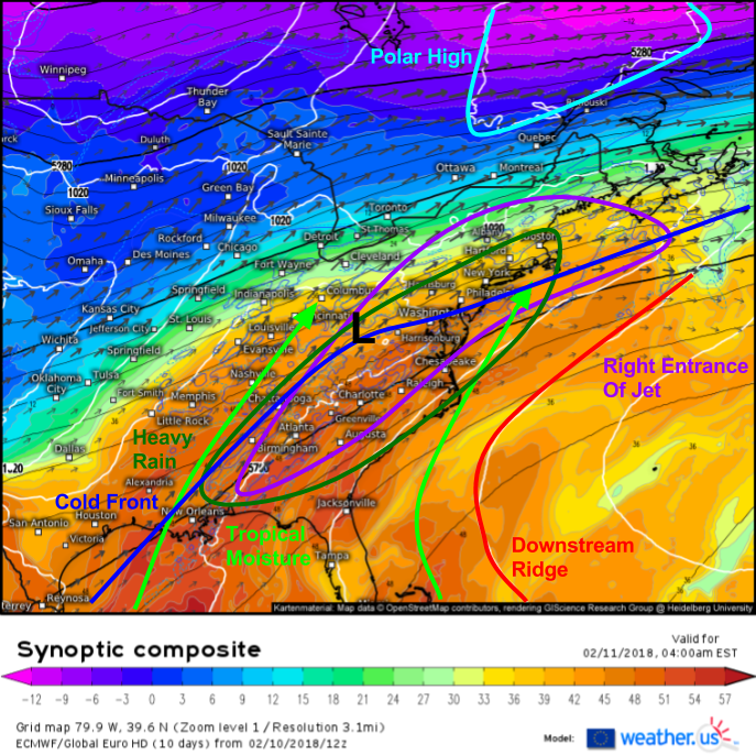
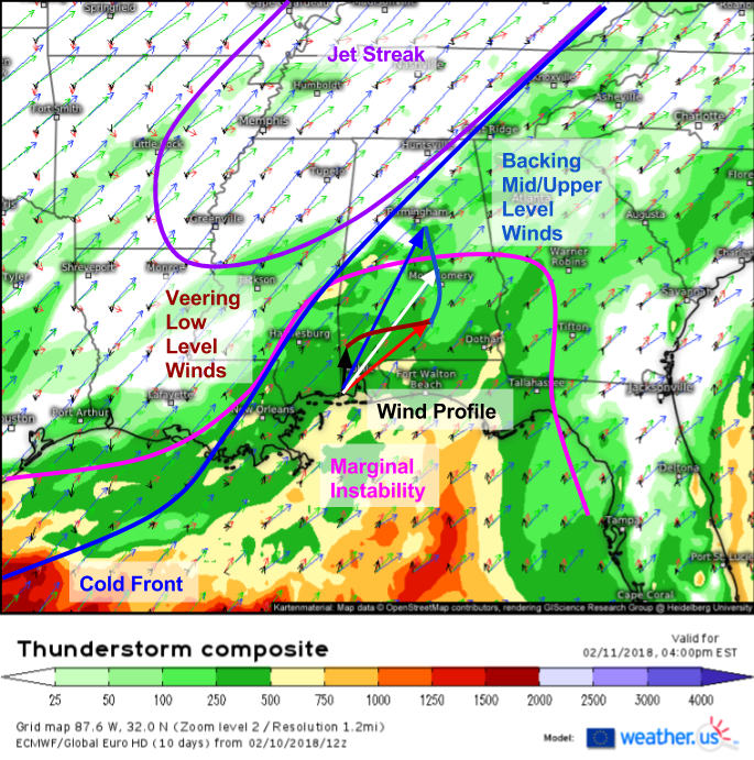
Many of the more significant impacts associated with this system will come on the warm side, from the Southeast through the Mid Atlantic and into parts of Southern New England. We’ve already discussed the tropical airmass that will reside in this region, and how the availability of so much moisture will accentuate the impacts of any forcing mechanisms that may develop. The ECMWF’s synoptic composite map (what’s that?) shown above highlights not just the moisture we have available, but also the forcing mechanisms. A wave of low pressure will develop along the stalled cold front and lift NE tonight. This process will unfold in the right entrance region of a strong jet streak, further amplifying rising motion in this area. The combination of rising motion and tropical moisture will lead to heavy rains in this area both tonight and tomorrow.
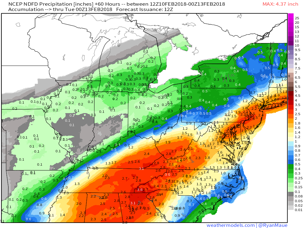
Here’s the National Weather Service’s total precipitation forecast highlighting a wide swath of area from Southern New England through the Mid Atlantic and Southeast expected to get 1-3″ of rain between now and Monday. Some areas in the Southeast that see localized enhancements due to thunderstorm activity will see 4-5″ of rain. All this rain will result in minor to potentially moderate river flooding. This won’t be anything major, but watch for impacts in the low lying spots that are usually first to flood, and remember to never drive through flooded roadways if you do encounter them.
Map from weathermodels.com.
Moving even farther south, severe storms will continue to be a concern this afternoon/evening as well as tomorrow in parts of the Deep South/Gulf Coast area.
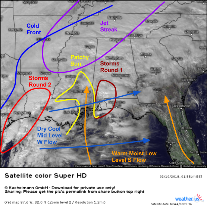
Here’s a visible satellite image from a little earlier this afternoon (click for current imagery) showing two areas of storms, plenty of wind shear, and a few areas of patchy sunshine scattered across the area of interest. The first round of storms brought severe weather to the Mobile area earlier this afternoon, and will be moving east towards the Florida Panhandle over the next few hours. These storms, as well as those farther to the west in Louisiana, exist in a highly sheared environment. You can see on satellite loops low level clouds moving from south to north and mid level clouds moving from west to east with time. This change in wind direction with height is known as wind shear, and will help to support storms capable of damaging winds and even a brief tornado or two through the evening. The cirrus clouds racing NNE over Tennessee and adjacent areas indicate the presence of a jet streak aloft. The right entrance region of that jet streak is right over Southern MS/AL, an area also seeing a little bit of patchy sunshine ahead of the next round of storms along the cold front itself. This may allow for just enough instability to fuel additional severe weather in the Louisiana-Mississippi area over the next several hours before storms wane with the loss of daytime heating.
Severe storms will return tomorrow in some of the same areas that saw storms today. The ECMWF’s thunderstorm composite product (what’s that?) shows plenty of wind shear (discussed above) as well as a forcing mechanism (the cold front), but instability will once again be limited due to the presence of clouds left over from tonight’s storms. This means that we’ll have a similarly marginal setup for severe weather tomorrow, with low end wind damage and brief spinup tornadoes. The wind profile shown by the vectors (which I made larger) shows veering winds with height in the low levels (sfc-850mb) and backing winds with height in the mid/upper levels (850-300mb). The type of storms that most often produce tornadoes, known as supercells, need veering winds with height to rotate properly. The presence of backing winds aloft is another indication that this severe weather setup will be on the low end, though it’s always good to remember that it only takes one poorly placed wind gust to make a storm “bad” for you, even if the overall setup isn’t all that impressive.
Be sure to use our HD radar and satellite products to track storms down to county level throughout this event. Just click the map to zoom into your region of interest!
By tomorrow afternoon, the storm will be starting to wind down and quiet weather will begin to return to the majority of the country. Snow and mixed precipitation will exit into Canada along with the wave of low pressure that enhanced rainfall in the Mid Atlantic. The tail end of the front won’t make much eastward progress due to the strong downstream ridging however, so expect heavy showers and thunderstorms to continue for the next couple days across the Southeastern states. However, with mid/upper level dynamics exiting along with the low, severe weather chances will decrease as we begin the upcoming workweek.
As always, you can find much more information on the weather in your town on weather.us.
-Jack
