A Subtropical Storm May Develop Off Florida This Weekend, But Poses A Very Limited Threat To The US
Hello everyone!
It’s not yet hurricane season in the Atlantic (officially, that begins June 1st) but we do have a tropical disturbance to keep an eye on this weekend. The system in question has yet to emerge as a coherent entity, but will do over southern Florida sometime on Friday afternoon. The window for development of this system will open after it departs Florida and heads into the northern Bahamas. Thus while this weekend will be a rainy one across the Sunshine State, there won’t be any significant impacts to worry about. If the system does develop near or north of the Bahamas, it will drift slowly north before turning northeast away from the East Coast. This post will take a closer look at each stage of this system’s expected development and why it’s not one to worry about.
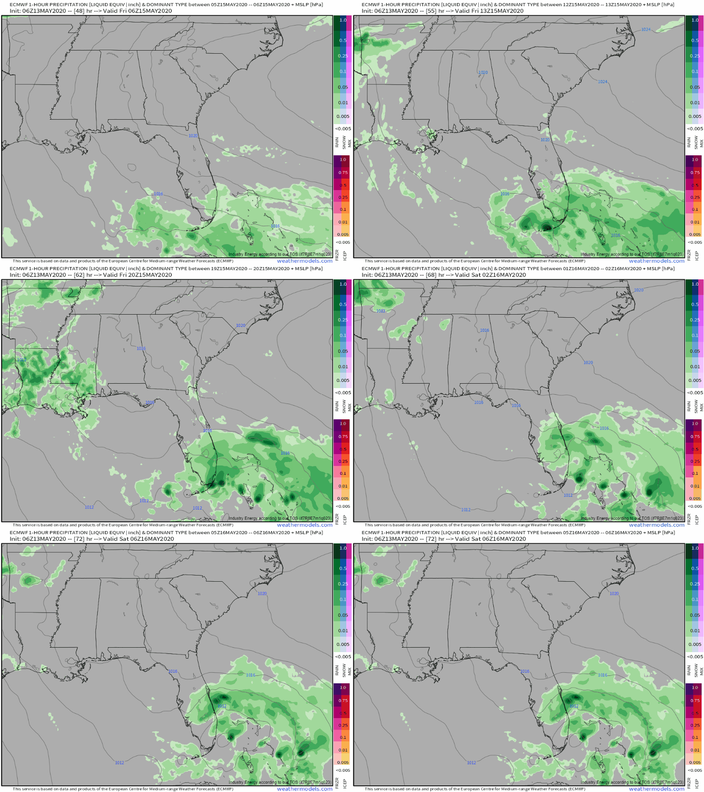
Here’s a look at the ECMWF’s forecast for the initial phase of the system’s development over southern Florida on Friday/Saturday. A loose conglomeration of showers and thunderstorms will slowly drift north from Cuba, eventually coalescing into a weak area of low pressure east of Miami. But does that area of low pressure count as a subtropical or tropical depression/storm?
Tutorial: Dynamic Tropopause
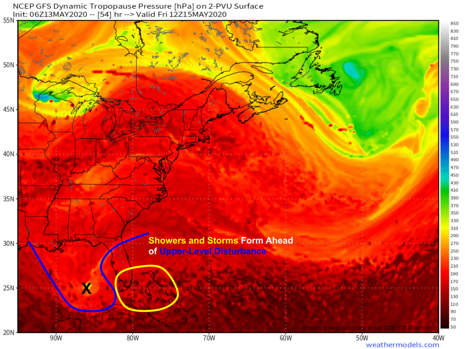
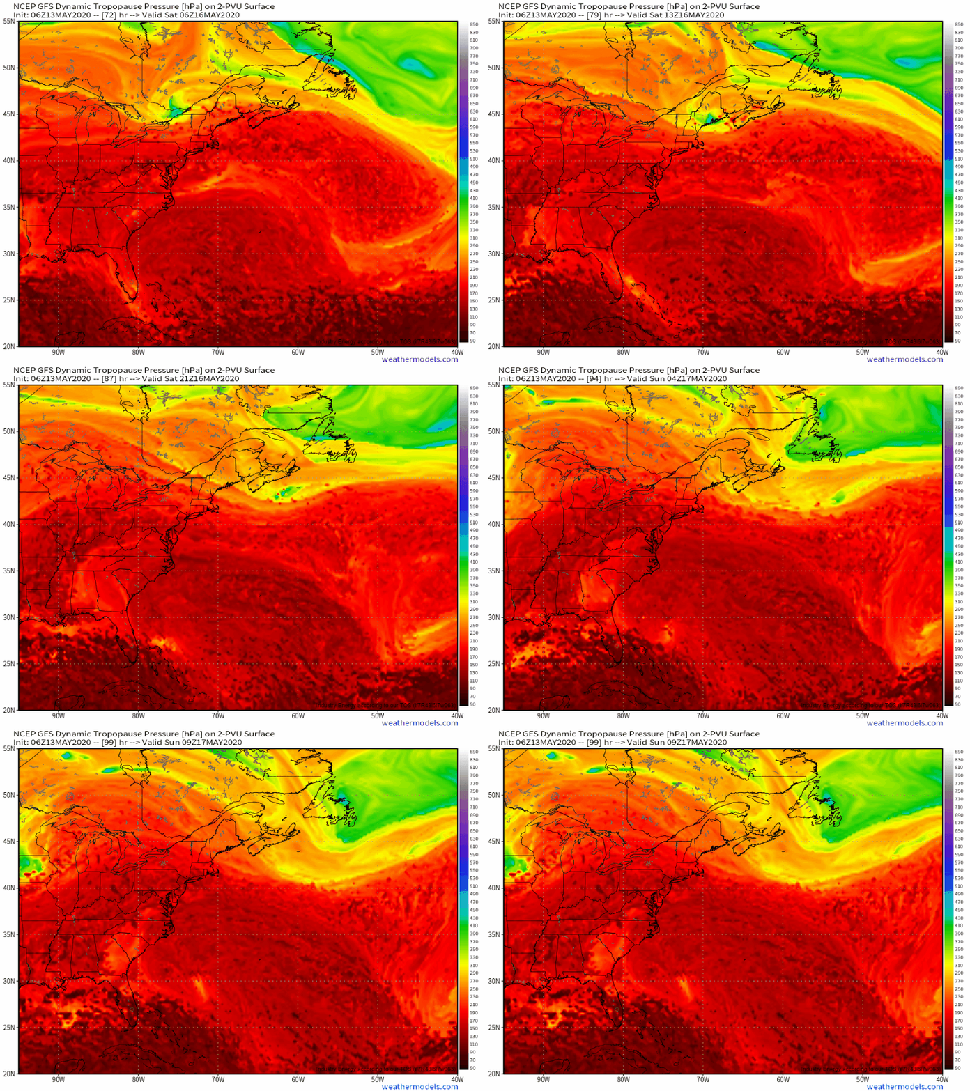
To answer that, we turn to Dynamic Tropopause forecasts from the GFS which help delineate airmasses in the upper atmosphere. We can only call this disturbance tropical if it has no connection to a pocket of upper-level cold air. The fact that the showers and storms associated with this system on Friday are located just east of such a pocket of upper-level cold air means that when the storm is impacting Florida, it won’t be tropical in nature, and thus won’t get a name or formal designation from the National Hurricane Center. Remember that doesn’t change its impacts (there will still be breezy rain) but if you’re looking for a named storm, you’ll have to wait until next week.
As the system moves east on Sunday, note that the pocket of upper level cold air(yellow dot) moves almost due east until it is located at roughly 30N/72W by the end of the loop. The disturbance and its shower/storm activity, on the other hand moves northeast to roughly 31N/76W by the end of the loop (you can almost see the implied thunderstorms bubbling up in this area). Though subtle, this dissociation is what we’ll need to see for our system to be deemed either a subtropical or tropical cyclone by the NHC. That said, as the upper-level cold pocket moves east, our system will lose its source of lift unless it can generate enough thunderstorm activity to support its own circulation. This is the fundamental process by which tropical cyclones gain strength.
Tropical Tutorial: Subtropical vs Tropical Storms
For this to happen on Sunday/Monday, we need two basic ingredients: warm waters and low vertical wind shear.
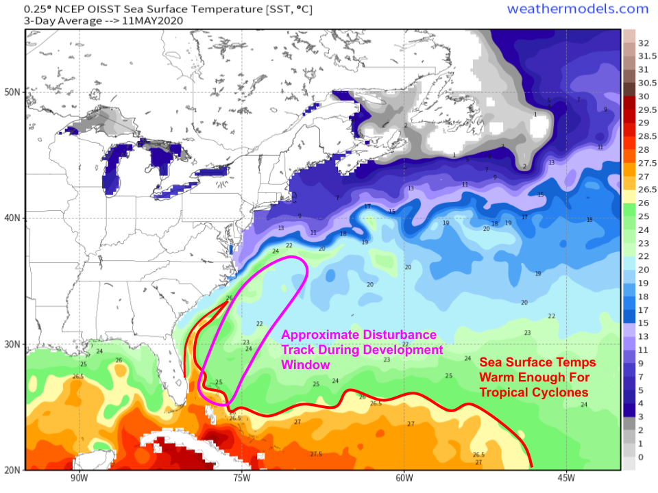
As far as the warm waters go, there isn’t much to see this time of year (as expected). Usually we look for SSTs greater than 26C to support tropical cyclone development, and for most of the time when the disturbance will be developing, it will be traversing over SSTs between 22 and 25C. This further supports the idea that whatever develops this weekend will be both weak and not fully tropical. Given cool temps in the upper atmosphere (remember that upper level cold pocket we talked about earlier), the threshold for favorable SSTs will drop to around 23-24C, giving this disturbance a brief window to develop before it moves north of the 30th parallel.
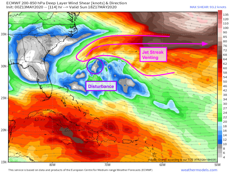
As far as shear goes, the upper level environment will actually be configured quite favorably for tropical/subtropical development. The disturbance itself will be located under a weak area of upper level high pressure which will help keep the system upright. Furthermore, a strong jet streak will be located just north of the system which will help with ventilation and upward motion near the storm’s center.
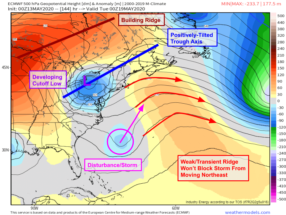
Regardless of the extent to which this system develops, its steering pattern is pretty clear at least early in the week. A ridge downstream of the system will prevent it from moving due east, but anticyclonic wavebreaking over the Great Lakes/Northeast will ensure that this doesn’t make a run at the US coastline on Monday. By Tuesday, the steering picture becomes a bit less clear as the developing cutoff low strengthens and dives southward. If that low digs far enough south, it could capture our disturbance and send (what’s left of) it back towards the coast.
Tropical Tutorial: EPS spaghetti plots
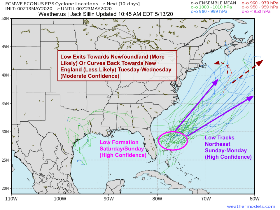
Here’s a look at what EPS guidance is thinking about the storm’s general track. There’s high confidence in low formation northeast of the Bahamas on Saturday/Sunday. There’s high confidence that whatever forms (nontropical low/subtropical low/subtropical storm/etc.) here will track northeast on Sunday and Monday. The main track uncertainty surrounds a possible turn west/capture by the cutoff low on Tuesday. While some guidance is hinting this is possible, it wouldn’t result in a meaningfully different outcome from the breezy rain currently forecast to impact parts of New England from the nontropical system expected to develop ahead of that cutoff low. Given that this unusual interaction between the pseudo-tropical system and a cutoff non-tropical low is still 6 days away, there’s plenty of time for forecast guidance to settle on one outcome or the other.
Either way, this will be a very low-impact event for the entire US East Coast. Some much-needed rain will fall in southern Florida on Friday/Saturday, rip currents could cause problems along the Southeast and Mid Atlantic coastlines on Sunday/Monday, and New England may see some modest enhancements to regularly-scheduled breezy showers on Tuesday/Wednesday.
While this system is nothing to worry about, it is a reminder that unfortunately hurricane season is coming right up. Now is a great time to think about what adjustments you may need to make to your hurricane preparedness plans in light of COVID-19. Don’t wait until a storm is on your doorstep!
-Jack
