A Most Disastrous Derecho, One Year Ago
I spend a lot of time thinking about weather records.
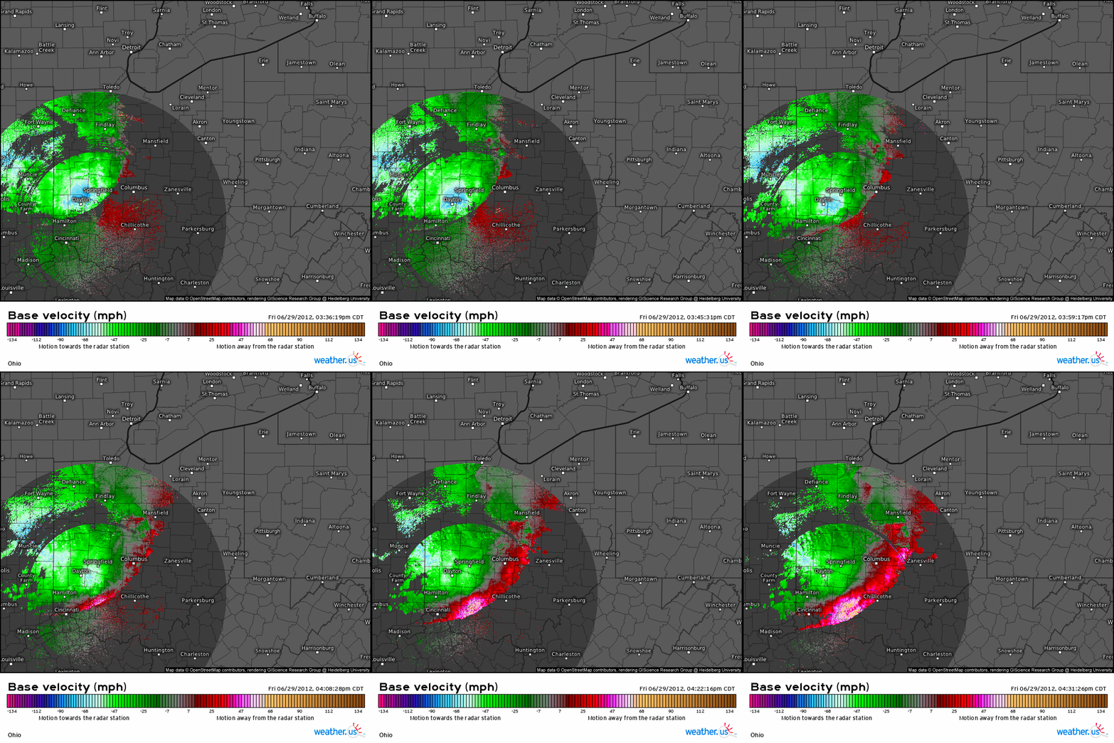
Some events seem so perfectly suited for setting records that they appear, with retrospect, unapproachable. For example, take the derecho of June 29th, 2012. A thunderstorm complex developed around 6am CST and coalesced into a small bowing segment that mauled the Chicago metro with winds in excess of 70mph before turning towards the southeast. As it raced through Indiana and Ohio, fanning out into a massive bow, it produced gusts that locally topped out above 90mph. It briefly weakened over West Virginia before restrengthening and plowing into the DC metro with winds that again approached 90mph. By the time the stunningly powerful, immense, and well organized mesoscale convective system blew into the Atlantic ocean around 2am, 22 had been killed and 4.2 million had lost power in an event that would immediately go down in history for the devastation left in its wake, spanning two massive metropolitan areas a thousand miles apart and causing ~3.5 billion dollars of inflation adjusted damage.
The damage that accumulated as the derecho roared through three of the largest metro areas in the US was astronomical, and seemed the perfect juxtaposition of an incredibly intense and long-lasting storm system with a very densely populated corridor of the country. It was by far the costliest convective wind event ever.
I love weather records, and know them well. I assumed it would be impossible to beat the June 2012 derecho’s damage statistics for a long, long time. I certainly did not expect the substantial record from that event to fall to another within a decade, and never in my wildest imagination did I anticipate by how much.
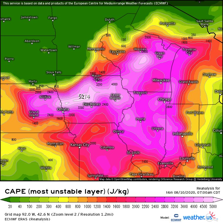
Enter August 10th, 2020, a hot and humid Midwest morning not unlike today. An immense blanket of high pressure aloft, not atypical for the dog days of summer, allowed a stout EML to drift all the way from the Southwest without threat of convective disruption. As the associated sky high lapse rates vowed a density through the troposphere far higher than a parcel of condensed surface air, all that was needed for explosive instability was sufficient surface moisture. This near-ground saturation developed as corn sweat and evaporated Gulf water conspired above the Midwest, and CAPE was already registering extreme values in excess of 5000j/kg over Iowa by 7am.
The atmosphere buzzed with energy that morning, sending a clear message- lifted air over Iowa had the potential to explode into updrafts capable of substantial damage.
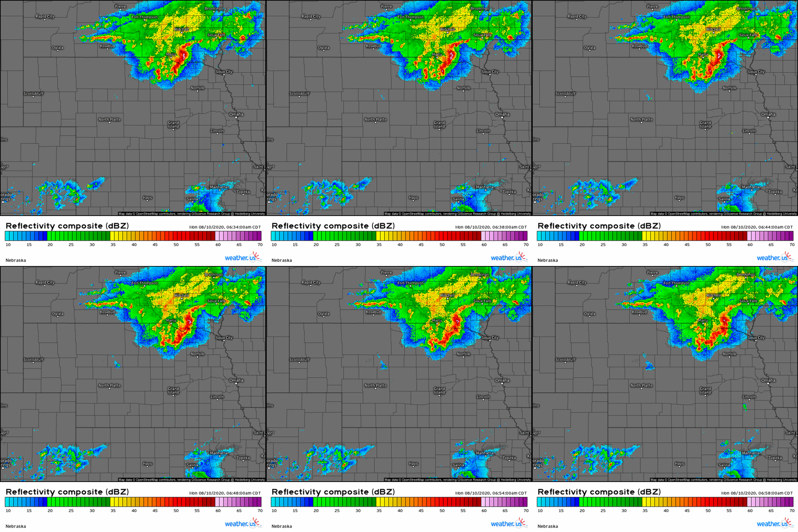
Dozens of these potentially explosive days happen every year. But something made August 10th, 2020 special- a complex of storms, already bowing out into an organized MCS by sunrise, tracking east near the NE/SD border.
The near-ground air was still stable, though, ahead of the MCS, and no severe reports were recorded for the first hour of the meteorological day (12z-12z) on the 10th. This was because of the bow echo’s location behind a slowly surging cold front, a detriment to descent that slowed sinking parcels to subsevere speeds. Recognizing a potential threat should the MCS propogate ahead of the cold front, the SPC added much of Iowa to a slight risk, with eastern sections of the state under an enhanced risk.
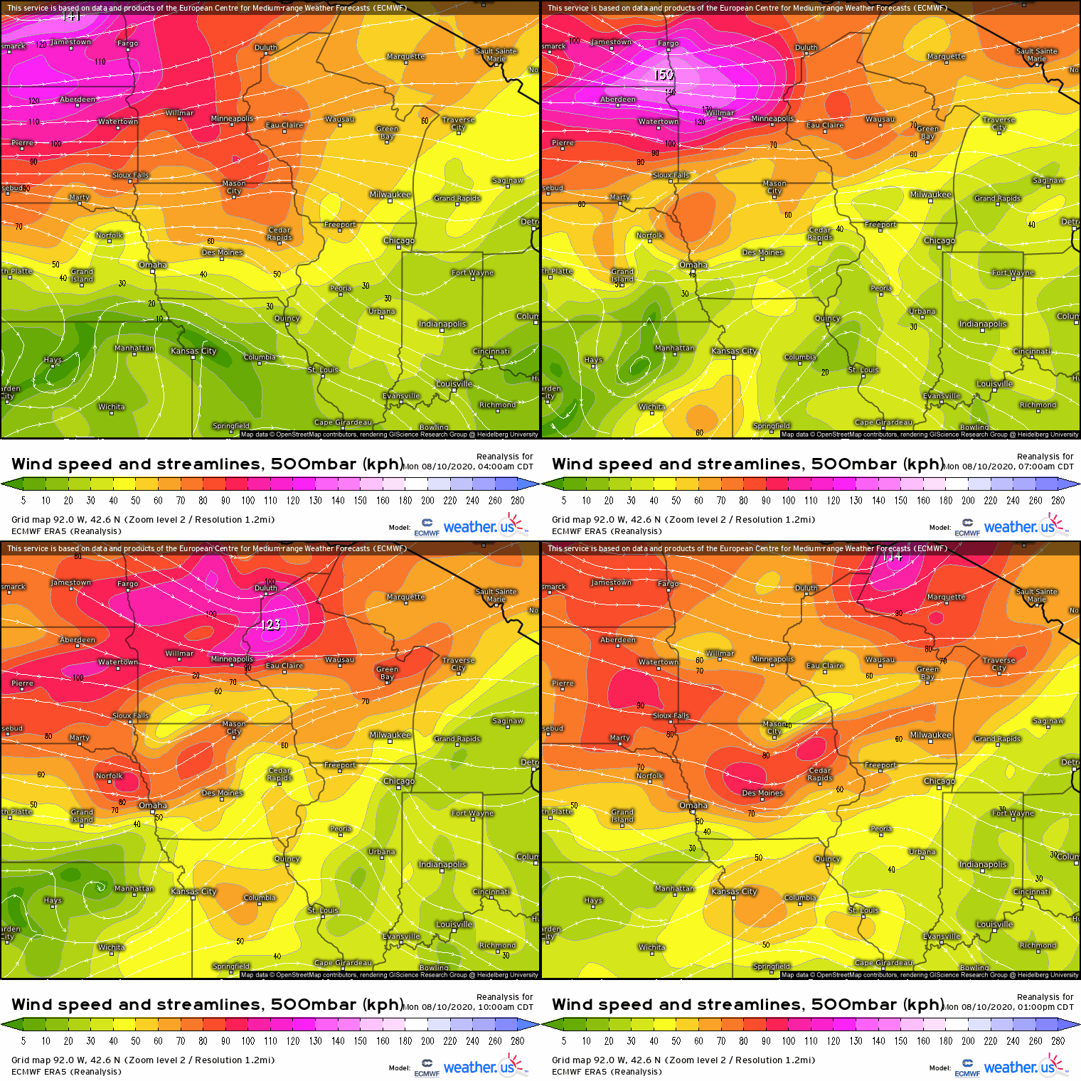
But the office underestimated the speed at which the developing rear inflow jet, bolstered by a vertically stacked, synoptically originating speed max, could incite thunderstorms downstream.
MCSs that end up establishing equilibrium with their environment require a tricky combination of plentiful downstream instability and shear sufficient to keep storms not only organized, but also propagating at the same rate as their rain-cooled outflow pool’s front. This front, like those that develop from cyclone processes on the synoptic scale, slopes vertically upward from the surface, and can incite further storm initiation as it moves though unstable air. Unlike synoptic-scale fronts, though, these MCS fronts develop from the descending ‘rear inflow jet’ of dense, rain-cooled thunderstorm downdraft. In addition to propagating the convective machine forwards, a mature RIJ is often associated with substantial wind gusts that can exceed 100mph.
So, thunderstorms in equilibrium with shear and amidst plentiful instability can incite RIJ development, which in turn incites further storm development in a process that is quite good at self propagation, but that requires either vigorous sustained updrafts, luck, and a little bit of synoptic help to get going.
On 8/10/2020, that came about as the horizontally descending speed max associated with a shortwave mentioned above collaborated with the outflow from intense morning thunderstorms to accelerate the MCS eastward.
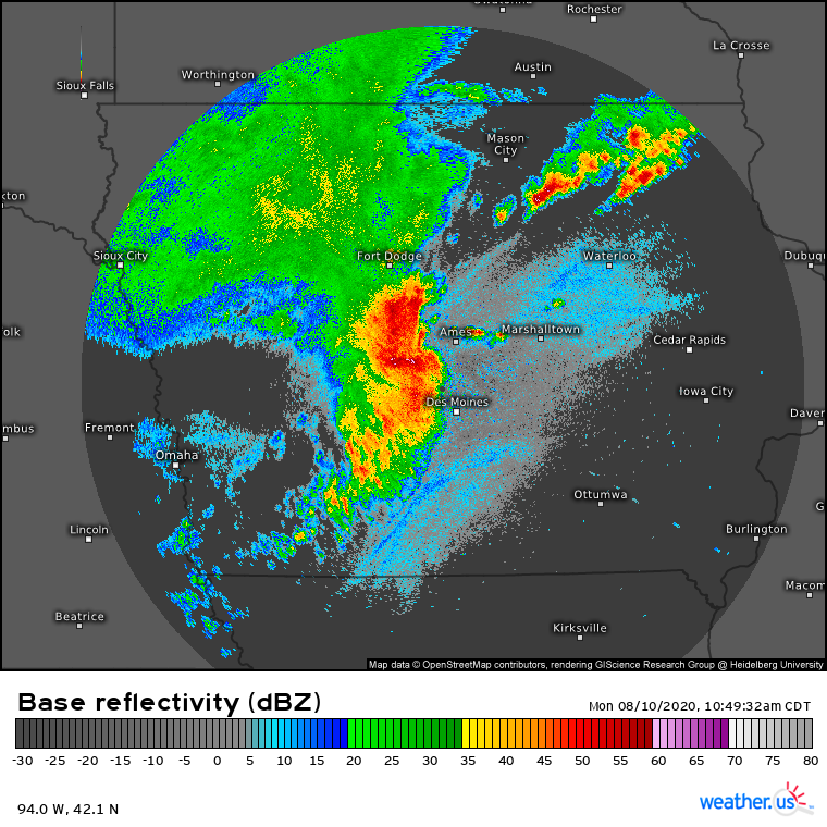
By mid-morning, the dense jet of cold air had become established aloft, and the bow echo accelerated to the east, moving into the pool of extreme surface-based instability over Iowa. Severe wind reports began rolling in as the MCS crossed into the state, with the rapid speed and descending RIJ coinciding with increasingly explosive updraft growth. By 11am, a line of incredibly intense storms had exploded in a solid band of constantly redeveloping convection along the nose of the cold pool and associated rear inflow jet, with the swath of wind damage increasingly including gusts to 85mph that destroyed property and blew trees into powerlines.
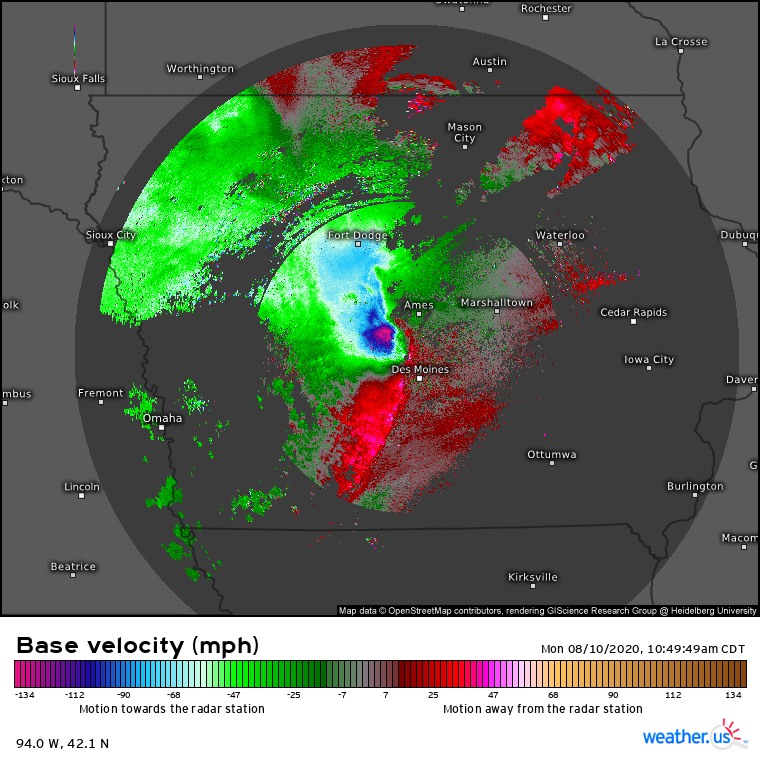
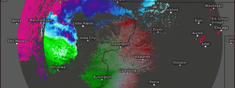
At this point, radar velocity returns exceeding 110mph only a few hundred feet above ground, evidence the inflow jet had become established close enough to the surface to cause extraordinary damage.
Clearly displaying an astonishing degree of organization and shear equilibrium, the inflow jet, now flirting with the surface, continued to intensify as the front of storms fanned out into an increasingly classic bow echo. The storms ripped through Des Moines, with more than 130,000 losing power as trees, roofs, and infrastructure were shredded.
Had the MCS slammed into a wall of stability then and there, obliterating the updrafts; if outflow speed exceeded storm motion, forcing the bow echo to dissolve into disorganized showers, it would have gone down as one of the more powerful derechos in modern meteorology. But neither of those things happened.
Instead, a pool of CAPE exceeding 4500 j/kg extended to the Illinois border, and ventilating shear continued the downstream propagation of convection along what was now a world-class RIJ. As the bow echo continued east, the descending wind actively continued to strengthen.
The next city in the path of the storms was Marshalltown. Here, winds to 99mph damaged thousands of structures with an intensity unseen outside of tornadoes, plowing through power lines, sending tens of thousands of cubic yards of debris into the streets, and snapping a substantial proportion of trees.
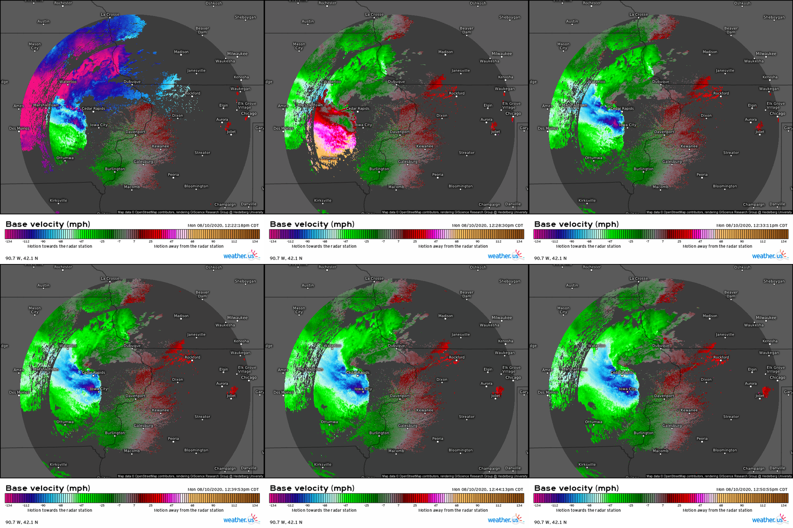
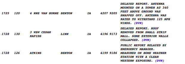
Unbelievably, the incredibly organized complex continued to intensify. By 12:30 that afternoon, as the compact bow approached Cedar Rapids and Iowa City, a rear inflow jet at the junction of incredible equilibrium and explosive atmospheric energy began causing damage likely exceeding any known sea level straight-line convective wind event. Winds gusting between 120 and 130 mph (!!) knocked over radio towers, ripped roofs off buildings, and plunged Cedar Rapids into a state of destruction akin to a county-sized EF2 tornado. The city itself saw 98% power loss, with almost 100,000 in the area still powerless a week later.
Finally, though, the MCS began to plateau in intensity as it hit about the roof of what the atmosphere can support. Still, though, 100+ mph wind gusts were reported well into Illinois as the bow echo continued to race east into the early afternoon, destroying radio towers and decimating trees. Swaths of wind exceeding 80mph caused widespread destruction in Iowa City and Davenport, though none as severe as Cedar Rapids. Increasingly prevalent too were imbedded tornadoes, which spun up by the dozen as portions of the line accelerated ahead of others. In total, 25 were reported in a narrow swath from central Iowa to lake Michigan.
As the bow continued deeper into Illinois, catastrophic winds continued. By 4pm, the MCS was knocking on Chicago’s door, with scattered winds that still exceeded 85mph that knocked over trees throughout the metro area. However, the bow was beginning to lose the much discussed equilibrium with the outflow boundary that had allowed it to develop such a high-end RIJ, and winds continued to weaken accordingly. Hurricane force wind gusts continued locally to the Indiana border, and severe wind petered out that night over Ohio.
Clearly, a convective event of historic proportions had struck Iowa and north Illinois that day. Easily classified as a derecho, thousands upon thousands of destroyed and damaged properties alongside millions of shredded trees and power lines forced parts of Iowa into a state of disrepair that lasted weeks. Across the state, farmers less than a month away from harvest were facing mangled dryers, crushed farm equipment, and flattened corn. The total costs exceeded 11 billion dollars, making it by far the most expensive non-tornadic convection event in modern American history.
The cost of the June 2012 derecho, which I had considered the unbeatable bellwether of convective wind events, was tripled.
That derecho had struck the Chicago, Columbus, Washington DC, and Baltimore metro areas. This one had hit several cities, too, but with combined populations a meager fraction of the 2012 event. But in raw power, this windstorm was different, and likely unprecedented.
I love studying weather records. I think it helps me identify which events could impact society to a historical degree. Sometimes, though, the incomprehensible happens, and I am blindsided. That’s what I learned one year ago today, on August 10th, 2020.

