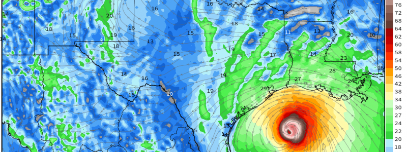
Laura Likely To Threaten The Upper Texas Coastline As A Major Hurricane Tomorrow Night
Hello everyone!
Laura has now emerged into the Gulf of Mexico as a strong tropical storm and is taking full advantage of the favorable environment for intensification. The storm is expected to become a hurricane today as it tracks WNW north of the Yucatan Peninsula. Intensification will continue tomorrow as the storm moves closer to Texas. By the time Laura arrives near Houston tomorrow night, it will most likely be a major hurricane (at least Category Three with winds of 115 mph). Track forecasts by the NHC and most model guidance have continued to drift slightly towards the west as questions about how exactly Cuba would interact with the storm get answered. Based on satellite imagery, hurricane hunter data, and the latest ensemble guidance, I continue to think that the storm is most likely to head for the Houston/Galveston area rather than the TX/LA border region. That said, this opinion is just mine and to the extent that my forecast differs from that of the NHC (by perhaps 40 or 50 miles as of their 5 AM advisory), please please please make crucial decisions based on their information.
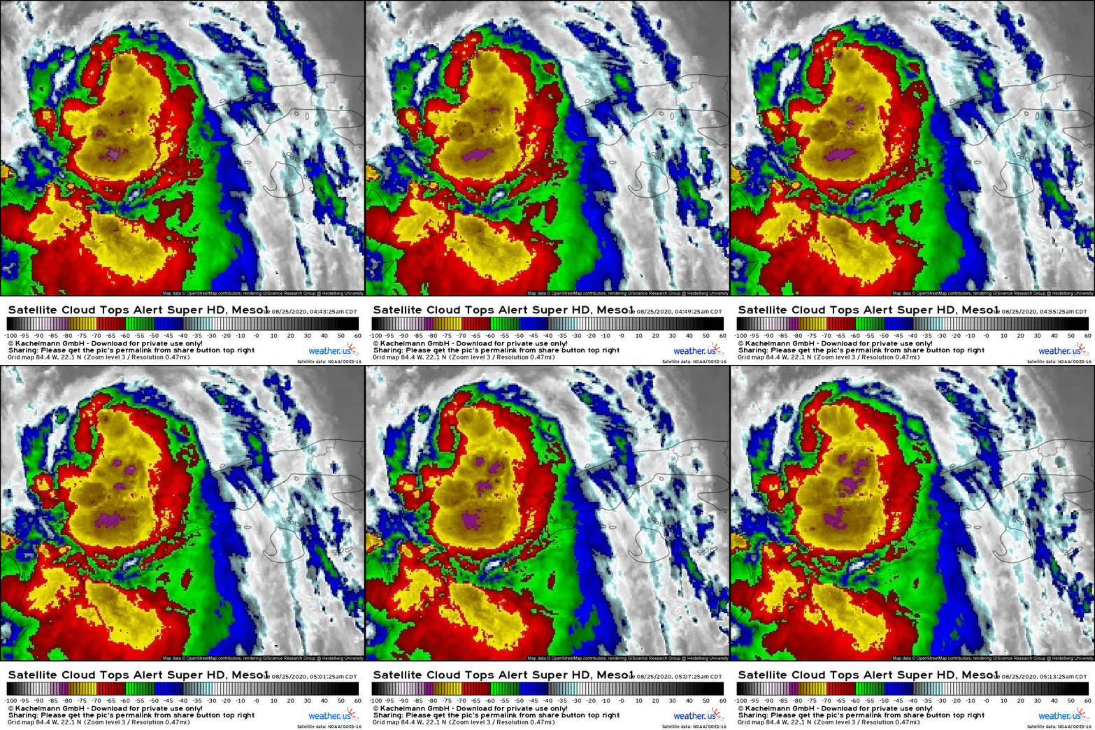 Morning satellite imagery shows a fairly healthy Laura well-positioned to intensify today. Most of the storm’s convective activity is still located near or south of the center due to some light northerly wind shear. That shear should relax today, and given the rest of the environment (little dry air, warm waters, etc.) is so favorable, I suspect that Laura will be able to push thunderstorm activity north of the center without much trouble by this afternoon or tonight. The fact that we’re already seeing extremely intense thunderstorm activity (cloud tops below -80C) pinwheeling north/northwest around the center this morning suggests that Laura is well on its way to shrugging off this shear.
Is there anything that might hold Laura back in the next couple days? The ongoing northerly shear and possible random disruptions to the cyclone’s inner core are probably our best hopes, though they are slim. One idea I’ve gotten many questions about is that there might be a pocket of cooler water left over from Hurricane Marco that would slow Laura down. Is that possible?
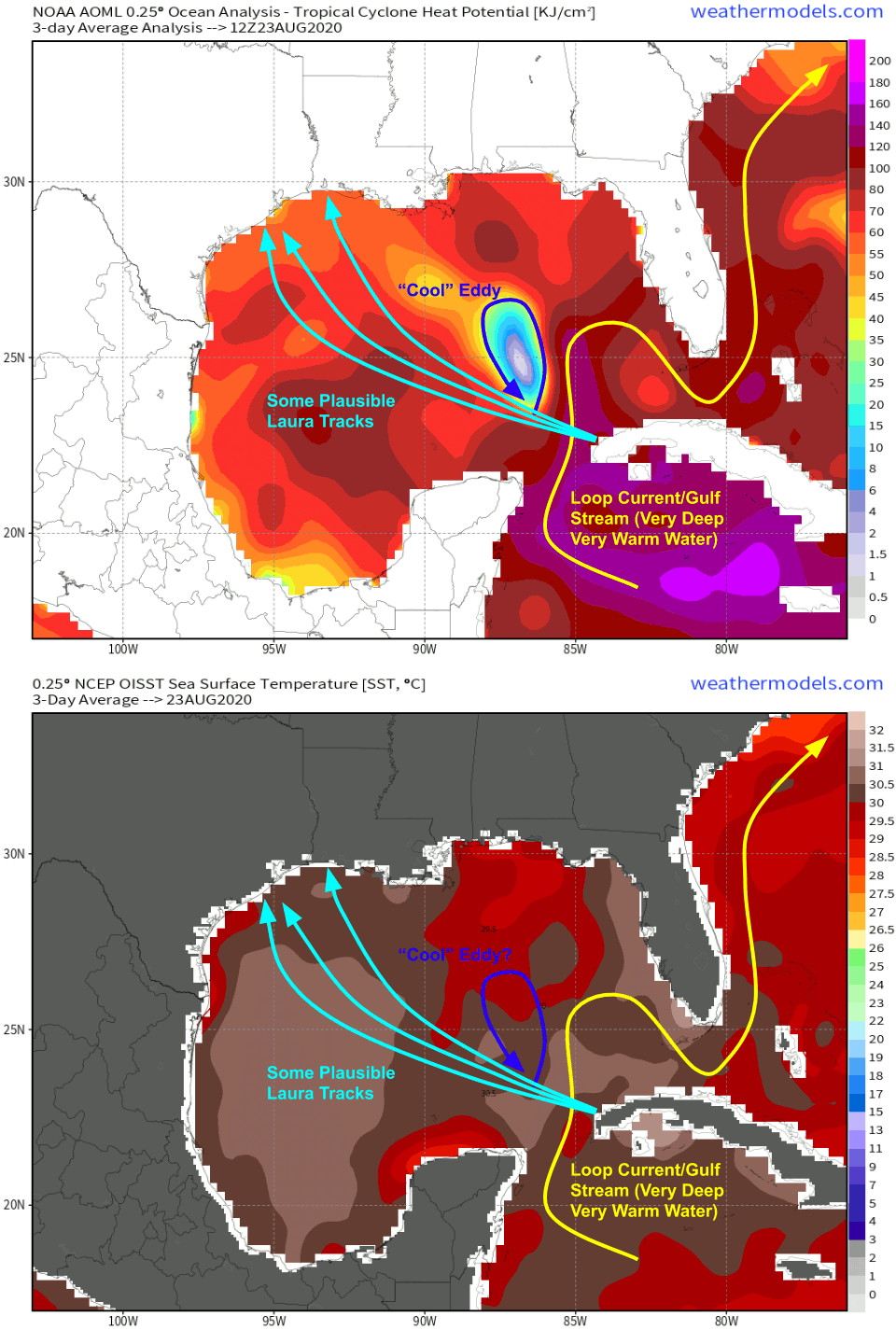 This pocket of cool water does indeed show up in Ocean Heat Content (OHC) analyses, but not on Sea Surface Temperature (SST) plots. Why might that be? Well this isn’t actually a cool wake from Marco. It’s a cool eddy in the loop current. How do we know? If this pocket was Marco-induced, it would show up on sea surface temperature analyses because the cooling from hurricanes occurs at the top of the ocean. The OHC analysis measures the total amount of heat in the entire ocean column. So the cool water we’re seeing in that analysis is below the surface. Why is that important? For a fast-moving cyclone like Laura, sea surface temperatures are much more important than the total ocean column heat. That’s because the storm only has time to “feel” what the very top of the ocean is up to. My the time it has mixed the ocean enough to draw cooler water (or warmer water) up from below, it has already moved onto a new area. So all that to say, this cold eddy may shave a few miles per hour off Laura’s intensity tonight, but otherwise the storm will barely realize it’s there. That’s also partially because the center will track along the very southernmost edge of that eddy, and will be moving perpendicular to the eddy’s N-S axis. If the storm were moving more slowly right up the core of the eddy, it would have more of an effect.
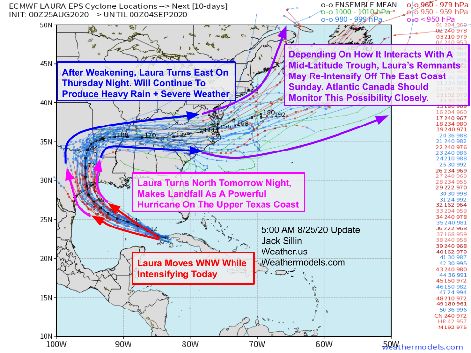 From a meteorological perspective, Laura’s forecast is pretty much locked in at this point. There’s the question of exactly where on the TX coast the storm makes landfall, and exactly how strong it will be at that time, but the margin of error there is starting to get much smaller. Of course these small-scale uncertainties are important for those in the path. But unfortunately, they are mostly governed by random or pseudo-random processes (inner core dynamics, distribution of convection, trochoidal wobbles, etc.). We can watch these wobbles in track and intensity happen, but we can’t really predict them ahead of time.
So in the second part of this blog, I’ll paint a broad-brush of possible/likely impacts and timing with the recognition that precision forecasts (+/- 5 mph winds or +/- 1″ of rain or +/- 1 foot of storm surge, +/- 1 hour in timing etc.) for any given location is hard to come by.
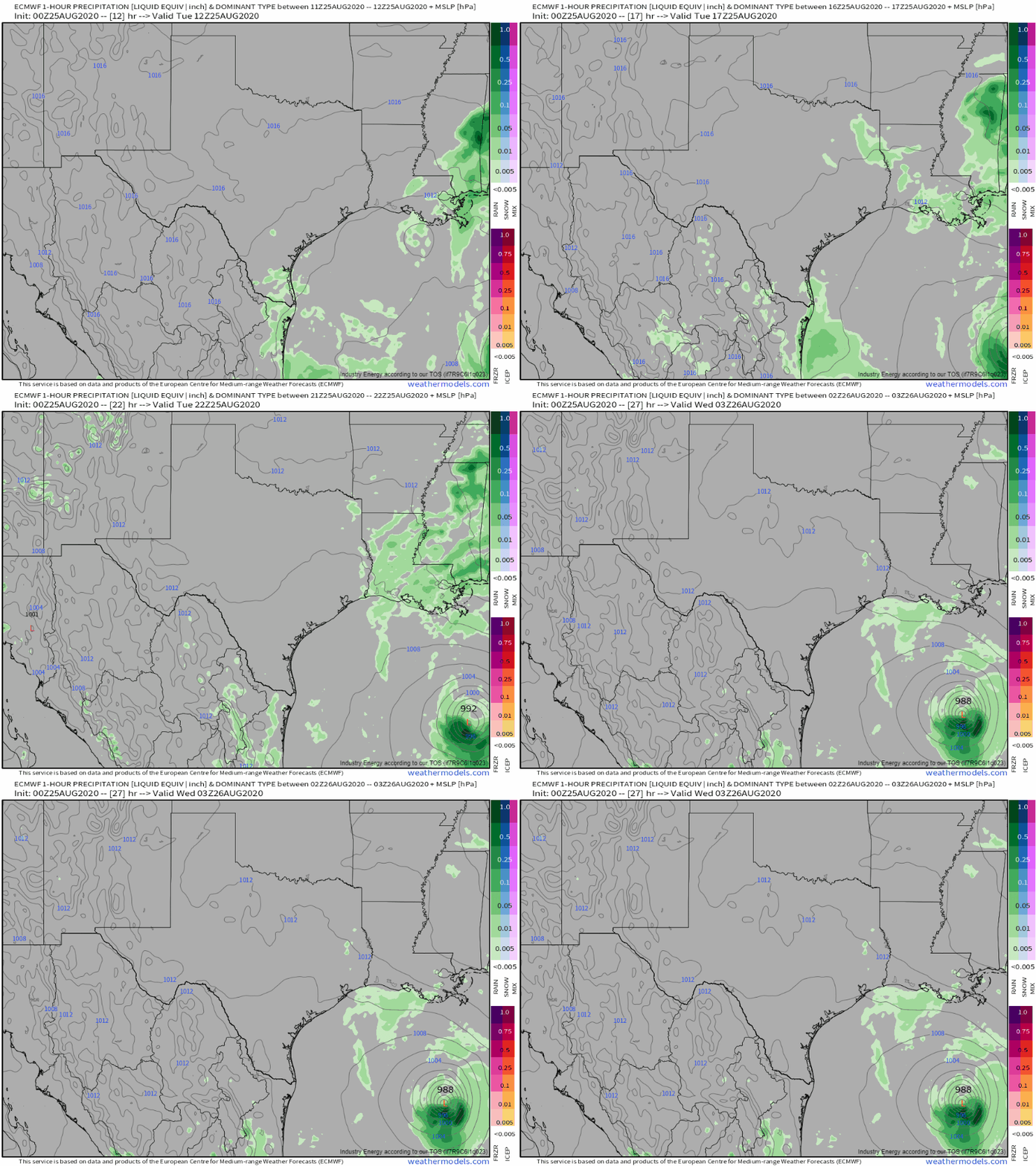 Conditions look good across the Houston and SE TX area today. Use this time to prepare for a major hurricane impact! You should have a hurricane plan ready to go and implement in accordance with advice from state and local officials. Please heed their advice when considering possible evacuations, shelter options, etc.! Farther east, the remnants of Marco will bring some showers and storms to parts of Louisiana this afternoon which may make preparations a bit more difficult. The first rain bands from Laura will approach the coastline late tonight and early tomorrow morning, bringing breezy conditions, squalls, and possible severe weather (tornadoes).
Stronger winds (TS-force) arrive on the coast tomorrow afternoon. All remaining preparations should be complete by this time.
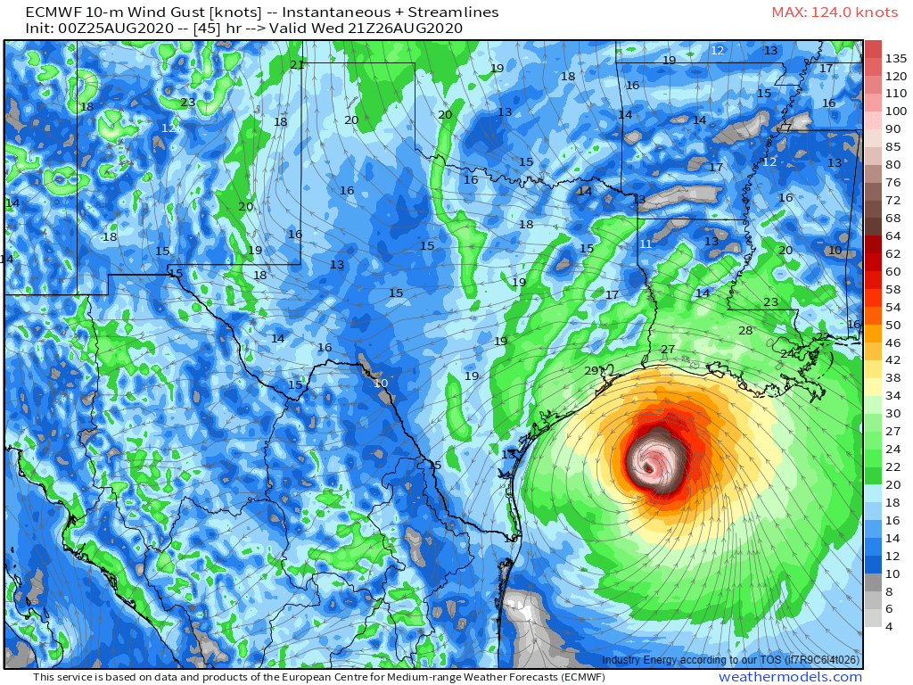
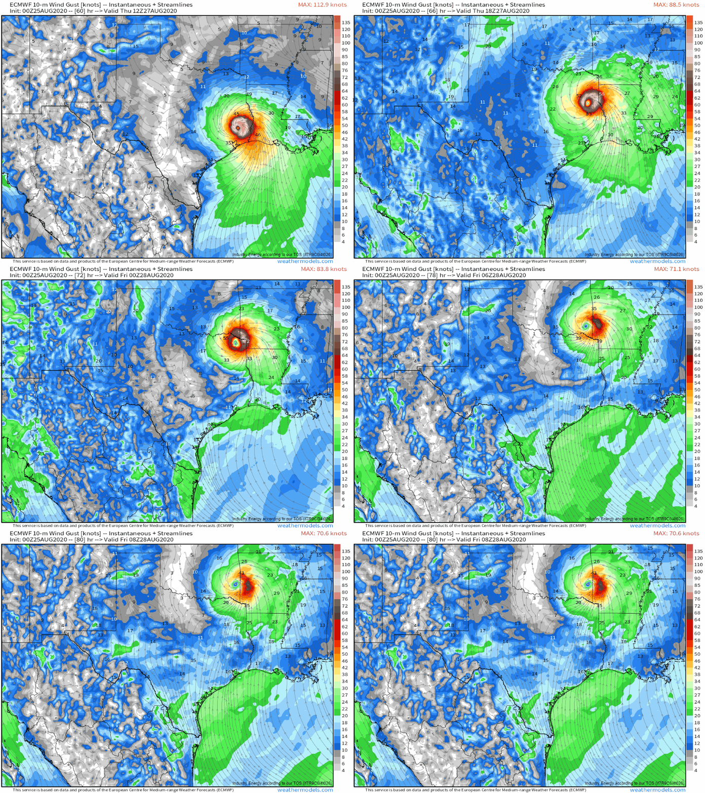
 Laura’s core will make landfall late tomorrow night or early Thursday morning, likely somewhere on the Upper Texas coast near or just east of Huston, and most likely as a major hurricane with maximum sustained winds in excess of 115 mph. As you can tell from this forecast map, the region experiencing these extremely strong winds will be relatively small. That’s why I’d suggest focusing more on the impacts expected in your area rather than whatever category the storm ends up being at landfall.
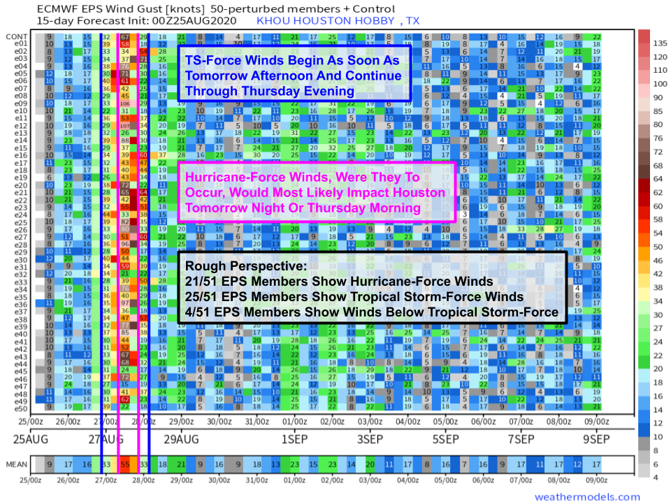 Also remember that the winds you experience at your location will depend strongly on those small/random wobbles in track and fluctuations in intensity we discussed earlier. This is best outlined by comparing wind forecasts for Houston from all 51 EPS ensemble members. Remember from the spaghetti plot above that the EPS mean takes Laura right over Houston, so its odds of strong winds (according to the ensemble system, which I happen to think probably does a pretty good job representing the range of possible outcomes but the NHC in their expert opinion considers to be a tad too far west) should be among the highest of any location. Even so, only slightly less than half of EPS members show hurricane-force winds at KHOU. That represents the set of members taking Laura right over or just west of Houston. If Laura wobbles even a little east, the city will end up in the less-windy western half of the storm, and will see strong TS-force winds which would still be impactful, but not as destructive as hurricane-force winds.
Remember that this is just one suite of model guidance and its range of possible outcomes may or may not do an accurate job accurately representing the true uncertainty in the forecast. That said, I think that its suggestion of hurricane-force winds vs TS-force winds being essentially a toss-up for Houston is probably not far off. That’s why we’re telling folks in this area to prepare for a major hurricane impact. If the track wobbles a little bit and you end up with “only” TS-force winds, consider it a welcome stroke of luck for 2020.
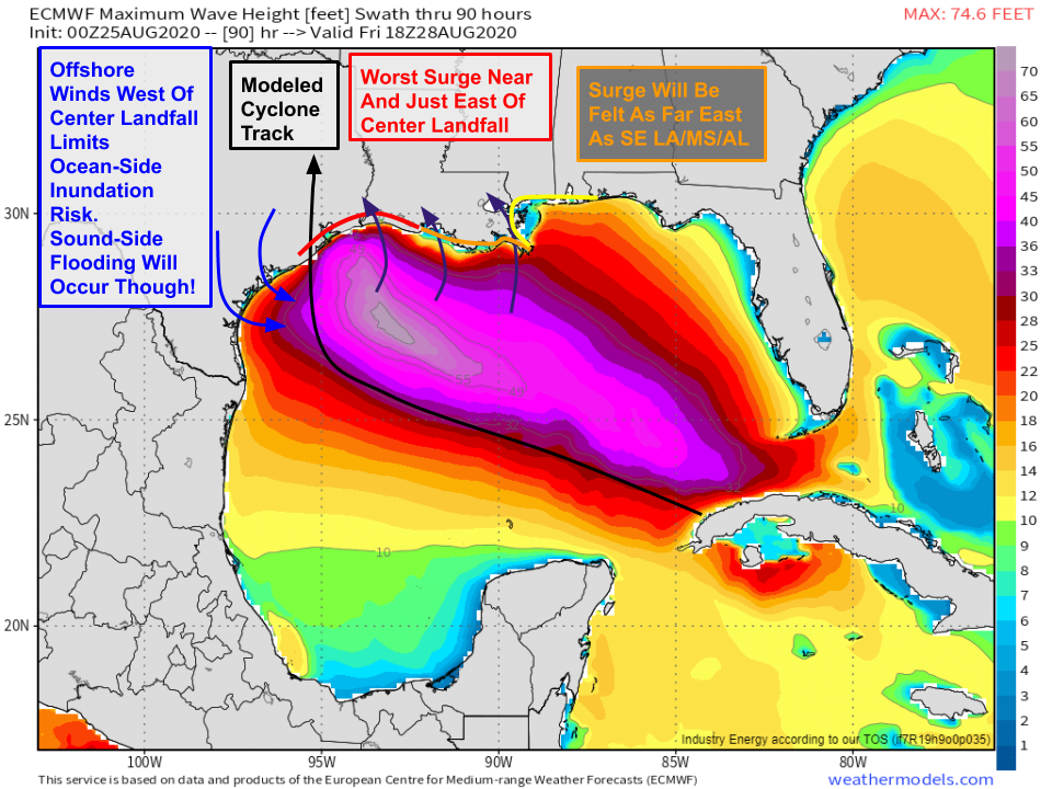
As Laura comes ashore, we’ll also have to worry about storm surge impacts. This map shows the maximum wave height forecast from the ECMWF. While this is not a perfect proxy for storm surge, it does show us where the ocean will be most substantially perturbed by Laura’s winds. The most significant surge will be found along and east of the center’s track, wherever exactly that ends up being. Strong onshore winds extending well east of the center will push surge impacts well east of wherever Laura ends up making landfall. Parts of Louisiana, Mississippi, and Alabama could see several feet of storm surge from Laura despite being hundreds of miles from the strongest winds. West of the center, the storm’s counter-clockwise circulation will limit ocean-side flooding but increase the threat for sound-side flooding in the barrier islands of the middle TX coast.
 Laura will also be producing heavy rainfall and associated freshwater flooding concerns. Thankfully the storm will be moving inland relatively quickly, so long-lasting extreme rainfall will not be an issue. Near the core, expect 6-10″ of rain in a relatively short time. This will cause urban/small-stream flooding and some responses on the larger rivers, but should generally limit the threat of major river flooding.
Laura heads north through eastern Texas, southeastern Oklahoma, and northwestern Arkansas on Thursday. Because it will move inland rather quickly, it will still be capable of producing strong winds even relatively far from the coast. Folks along and just east of the track should be prepared for power outages even hundreds of miles from the coastline.
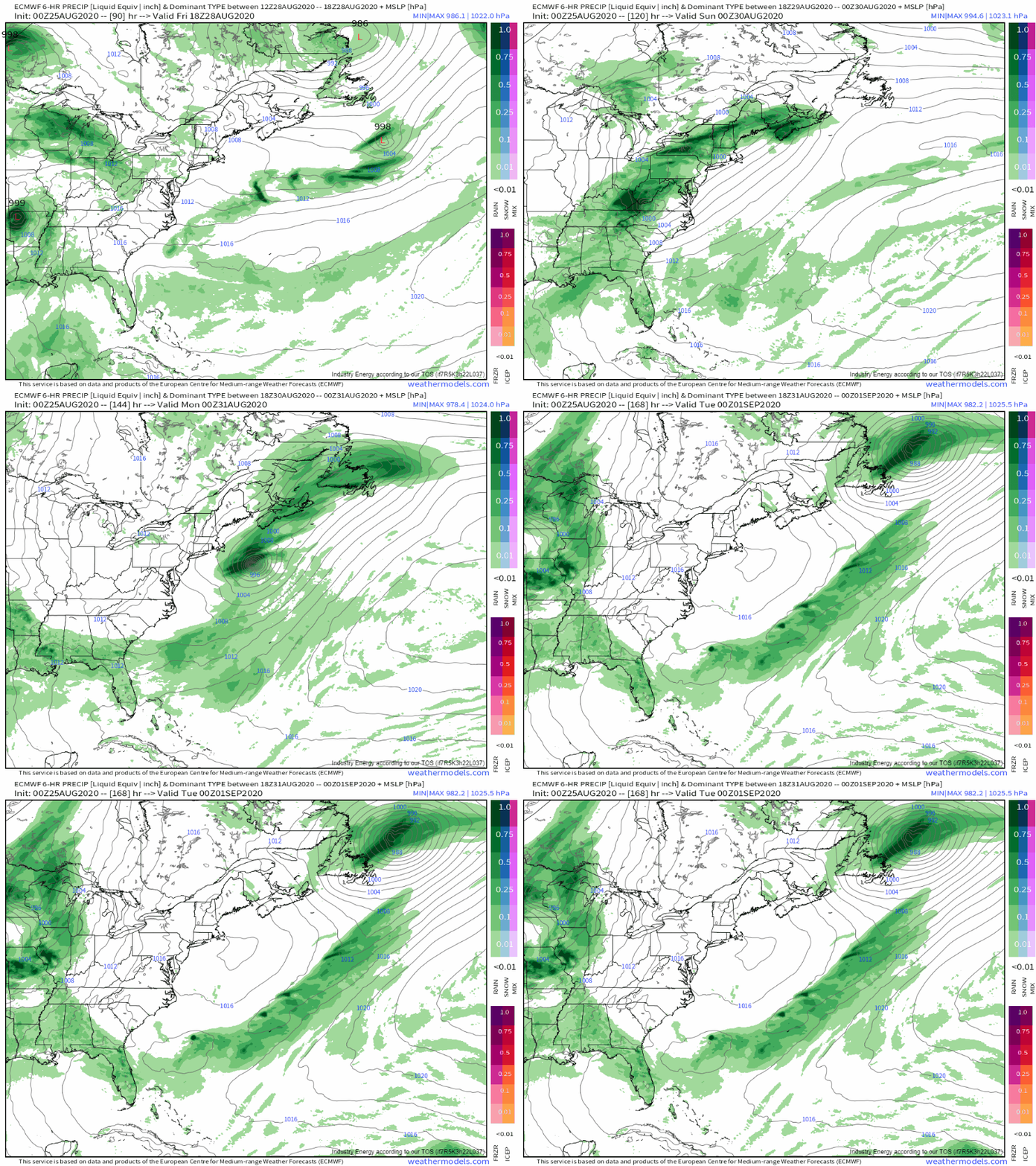
Heavy rain, gusty winds, and the threat for severe weather will spread into the OH/TN Valley region and the Mid Atlantic this weekend as Laura interacts with an approaching cold front. Atlantic Canada will have to watch for potential re-intensification of the storm as it moves over the northern part of the Gulf Stream and interacts with the jet stream. At that point, I don’t think the system would be considered tropical, but that will be up for NHC to decide at the time. Either way, strong winds and heavy rain may impact Nova Scotia and Newfoundland early next week.
5:30 PM EDT/4:30 PM CDT livestream broadcasts for Laura will continue today. Tune in for the latest info and to ask me any questions you may have about the storm.
-Jack


Way cool! Some very valid points! I appreciate you writing this post and the rest of the website is also really good.