Tropical Storm Laura Moving Over Hispaniola This Morning, Likely To Make Landfall On The Northwestern Gulf Coast As A Hurricane On Wednesday Or Thursday
Hello everyone!
Laura and Marco both remain strong tropical storms this morning as they move towards the US. Marco appears to be attempting to intensify this morning, and is likely to become a hurricane before arriving in Louisiana tomorrow. A full discussion of Marco’s forecast both from a meteorological perspective and from an impacts-focused perspective can be found in yesterday evening’s blog post. So far, I’m leaning more towards the stronger solution given satellite trends this morning, though it’s important to note that the system still has time to weaken before landfall if shear and dry air pick up a bit. Given that yesterday’s discussion of Marco remains current, this post will focus on Laura. After days of very high uncertainty regarding how Laura would interact with Hispaniola, we’re now seeing that interaction play out this morning. That means that we’re starting to get a better handle on how the system will behave over the next few days as it moves into the Gulf of Mexico.
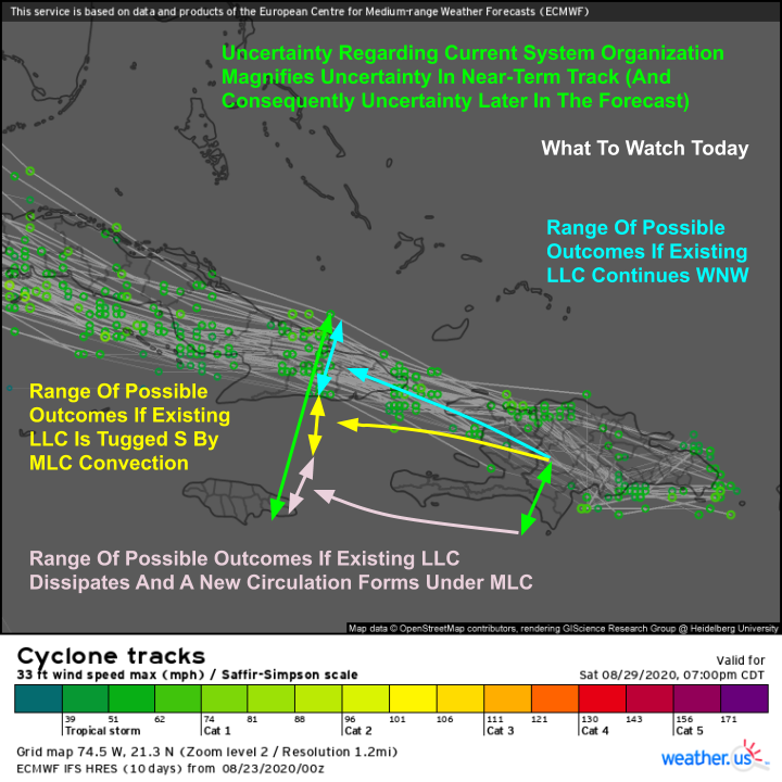
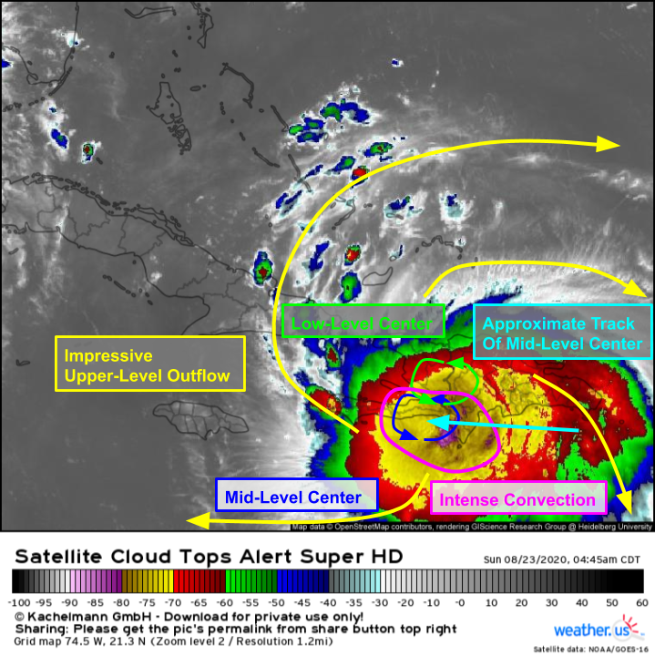 For a tropical cyclone in very close proximity to Hispaniola, Laura looks extremely healthy on satellite imagery this morning. The storm has been producing intense thunderstorms with cloud tops below -80C since yesterday and its upper-level outflow has improved dramatically since then. Hurricane Hunter data and surface observations show that the system’s low-level center is still displaced a bit from its mid-level center. How exactly these two circulations become aligned is a bit of a mystery, and will have significant ramifications for the forecast over the next couple days. I see three possible outcomes for center alignment: the existing LLC remains dominant and the MLC comes north to meet it (or they remain misaligned for a while), the existing LLC remains dominant but gets dragged south to meet the MLC south of Cuba, or the existing LLC dissipates and a new circulation forms under the MLC south of Hispaniola.
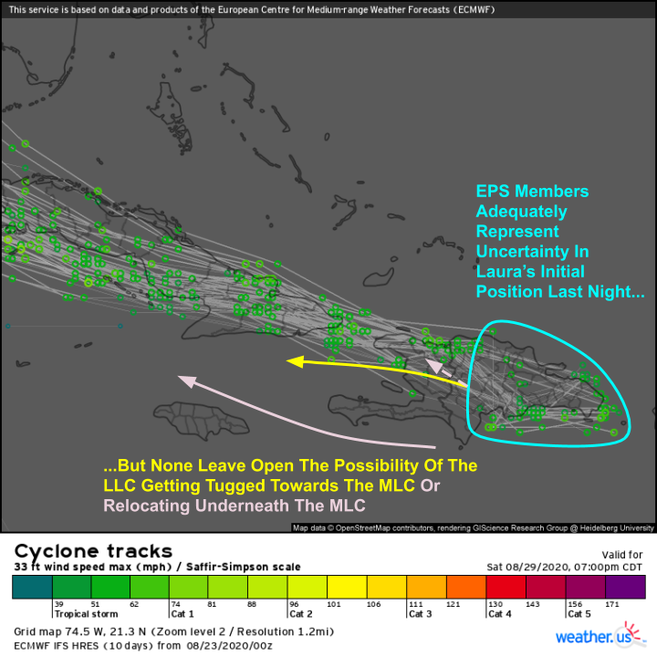
Last night’s EPS guidance did a good job representing the uncertainty in Laura’s initial position yesterday evening but I think is too confident in the existing LLC remaining dominant and continuing to track WNW (scenario 1). Based on hurricane hunter data showing strong southerly winds along the south coast of Hispaniola, I don’t think the last scenario of center relocation is particularly likely. There’s just too much angular momentum built up at this point, though as some of that momentum is dissipated over the mountains of Hispaniola, it can’t entirely be ruled out yet. After looking at more and more observational data this morning, I’m starting to think scenario two is most likely. That involves the LLC taking a jog to the west after leaving the western coastline of Haiti later this morning to meet up with the MLC. Why is that likely to occur?
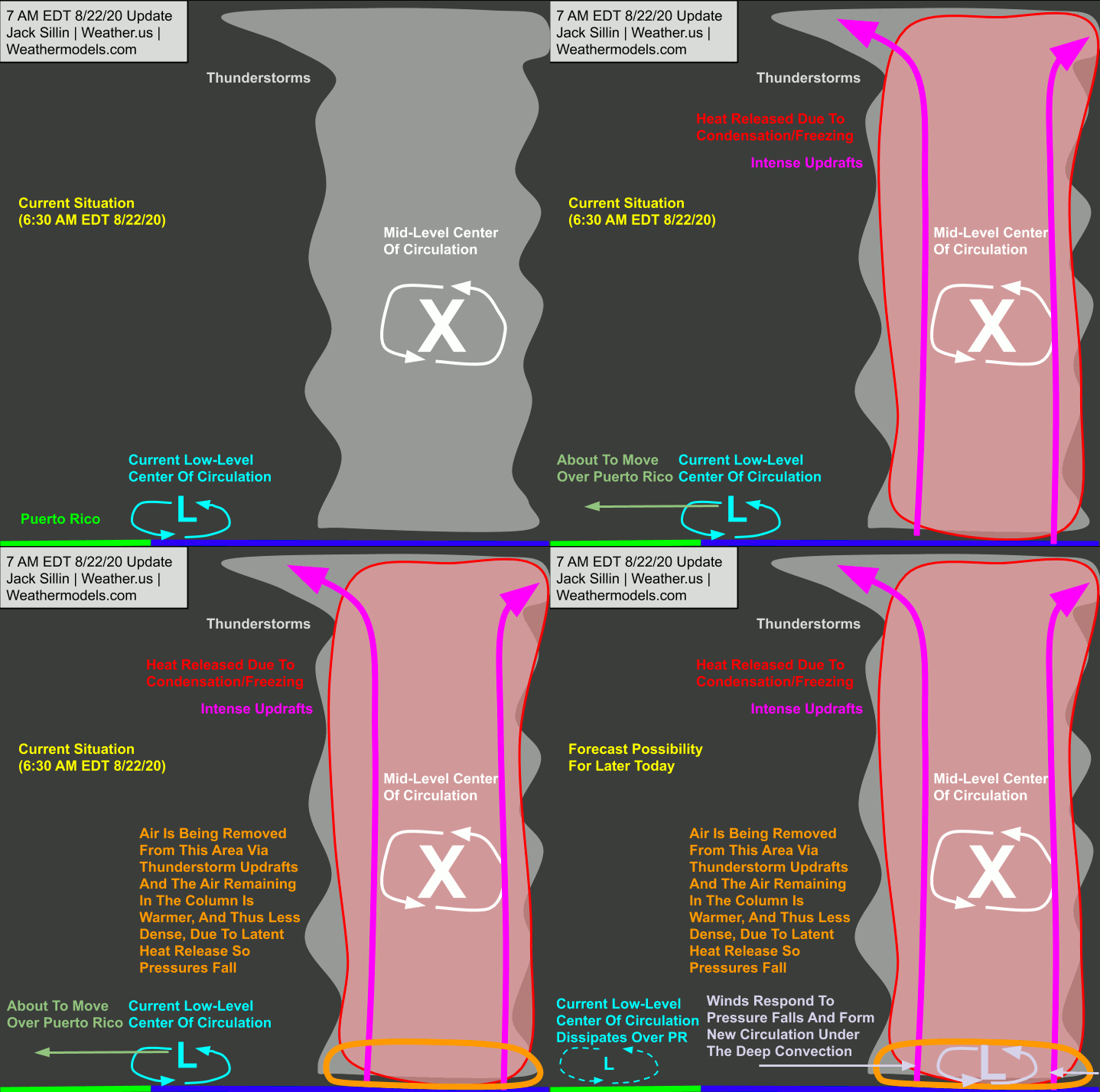 Recall from yesterday’s update that persistent deep convection promotes surface pressure falls through diabatic heating (release of latent heat from condensation/freezing) and upper-level divergence associated with upper-level thunderstorm outflow. If the intense convection we’re observing south of Hispaniola persist today, I have a hard time seeing the low-level center remaining misaligned given the lack of wind shear. As a quick note, this animation is to highlight how thunderstorm activity promotes surface pressure falls and was reused from yesterday’s update discussing a possible center relocation near Puerto Rico. It contains some outdated information about a “current” center of circulation about to move over Puerto Rico. The system is now well east of Puerto Rico and will not cause further impacts on the island.
So why is the exact process by which the LLC and MLC become aligned so important? Small wobbles in Laura’s track today will determine the extent to which the storm will interact with Cuba today/tonight/tomorrow morning. Ensemble guidance suggests that scenario one (existing LLC keeps moving WNW) would produce substantial land interaction with Cuba. Any wobble to the south would keep Laura’s center farther away from the high mountains of SE Cuba. A center relocation would put the system much farther south, though remember that’s probably an outlier scenario based on current information.
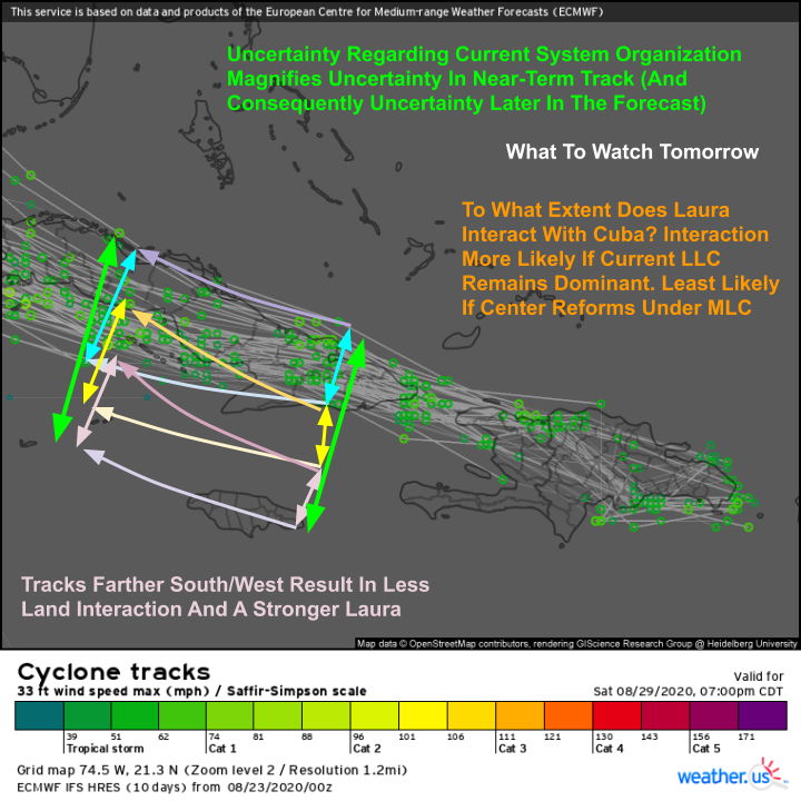 By tomorrow, the storm will either be moving right along the spine of Cuba or just south of its southern coastline. Again, slight wobbles here will make a big difference for the system’s intensity. The environment will be very favorable for intensification if Laura remains over water. If the storm moves inland, some weakening is possible. Right now, I’m starting to lean towards the “yellow” envelope of solutions (not currently represented in ensemble guidance but supported by some deterministic guidance like the UKMET) which would take the center right along the southern coastline of Cuba and possibly even a little farther SW over the NW Caribbean Sea. If this were to happen, Laura could reach hurricane status as soon as tomorrow.
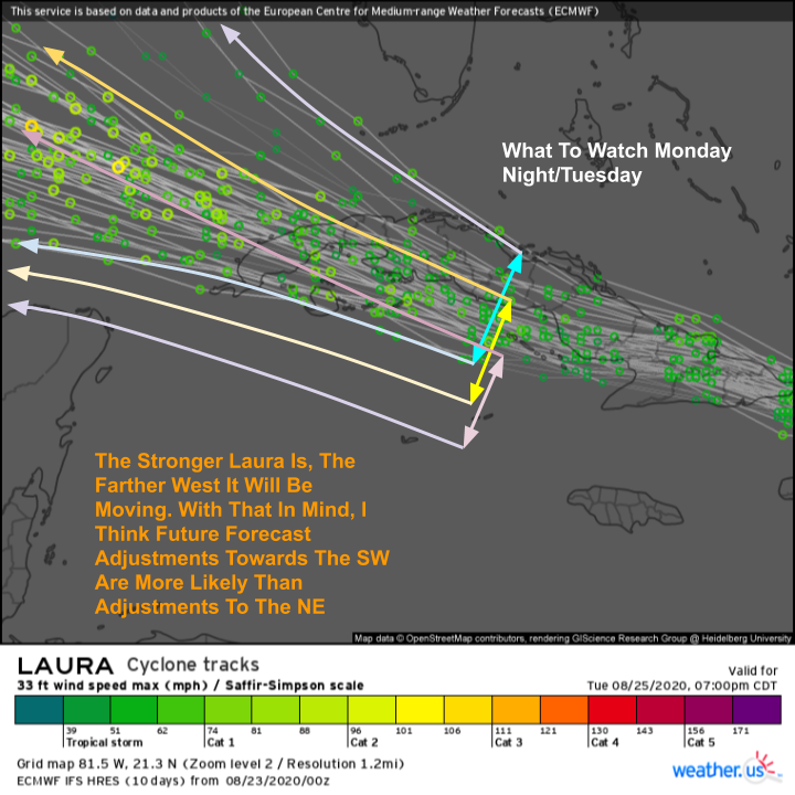 By tomorrow night, Laura will be wrapping up interaction with Cuba and en route to the Gulf of Mexico. At this point, ensemble spread in track solutions begins to widen as there will be considerable dependence of the storm’s track on its intensity, which of course will depend on how it interacts with Cuba. What we can say with high confidence at the moment is that a stronger Laura will track farther towards the west.
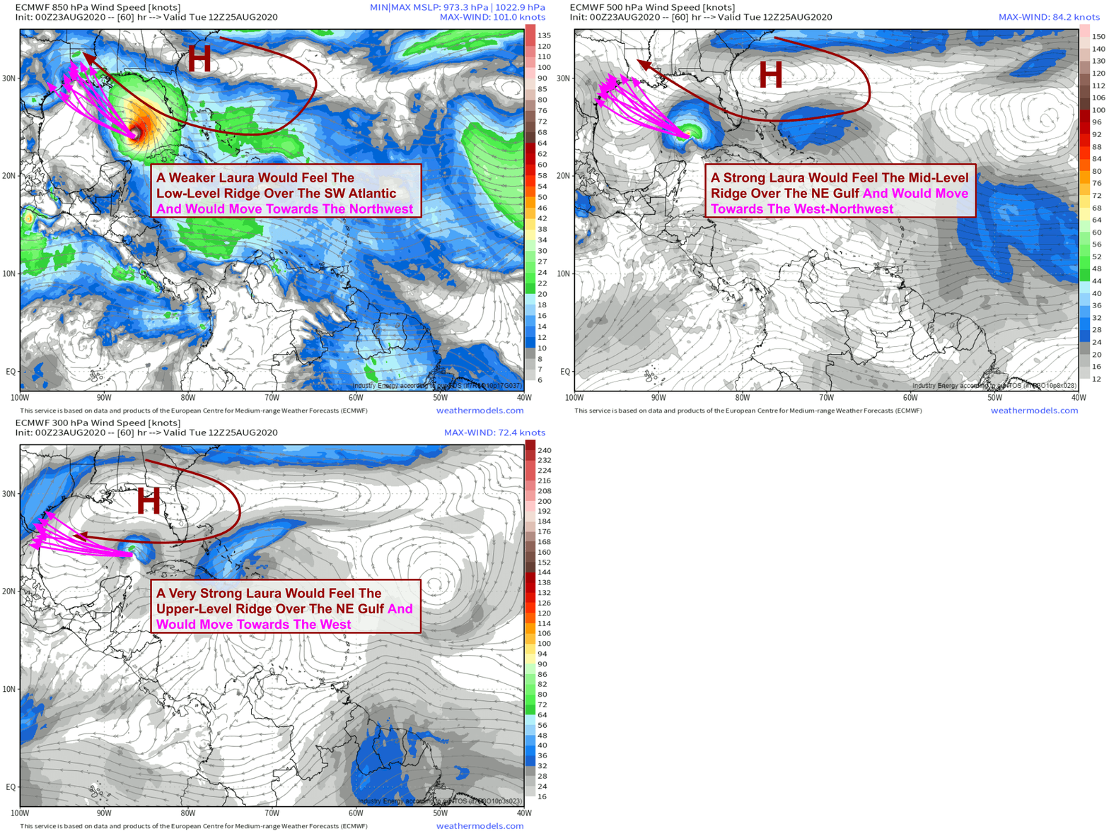 Why would a stronger storm go farther west? The answer lies in the environmental winds in the vicinity of Laura as it moves through the Gulf of Mexico. In the upper levels of the atmosphere, environmental winds are almost due easterly. That means that a strong storm would tend to move farther west. A weaker storm wouldn’t be able to “feel” those easterly winds aloft so it would be steered more by southeasterly winds in the lower atmosphere, resulting in a track farther northwest.
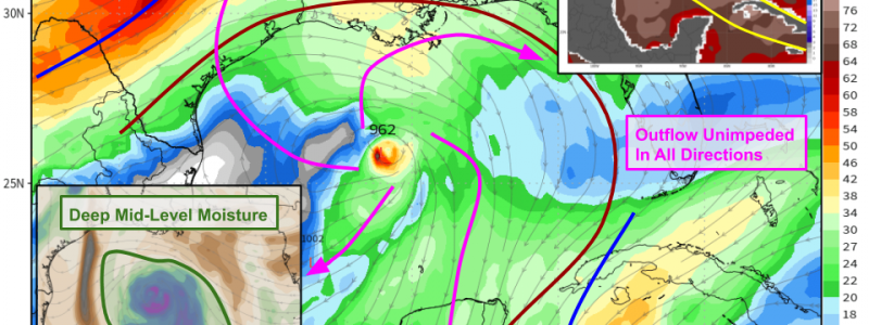
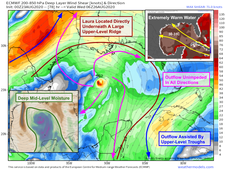 Once in the Gulf of Mexico, the sky is pretty much the limit for Laura’s intensity. Aside from organizational struggles resulting from land-induced circulation disruptions, there is pretty much nothing holding the system back on Tuesday/Tuesday night. Laura will be located directly under a strong upper-level ridge spanning the entire Gulf of Mexico. The nearest wind shear of note is several hundred miles northwest and southeast of the core in Texas and near Cuba. Somewhat paradoxically, this wind shear will actually help Laura by giving its outflow a boost. Remember that strong wind shear is only detrimental to a storm if located right near the core. Strong southerly winds over Texas and strong northerly winds over the Caribbean will push air away from the storm in the upper-levels, leaving plenty of room for air rising through the storm’s updrafts. Mid-level moisture forecasts show Laura embedded within a deep plume of moisture and little if any dry air in sight across the Gulf of Mexico (perhaps a little bit to the NW of the center?). Without any wind shear, Laura shouldn’t struggle too much with this dry air (if it has a strong circulation). Finally, ocean temperatures in the Gulf of Mexico are among the warmest in the world, clocking in at 30-31C. Remember we need SSTs >26C for tropical cyclones and >28C for strong hurricanes. Anything above 30C is pure rocket fuel.
All that to say that I’m quite bullish on Laura’s intensity in the Gulf of Mexico assuming it maintains a coherent circulation after interacting with Hispaniola and Cuba. Model guidance is fairly confident that Laura will be a major hurricane when it makes landfall in TX or LA on Wednesday. I think this is perfectly reasonable given the environment. Residents in TX and LA should be watching forecasts for Laura extremely closely and should begin preparing for hurricane impacts this week. This is especially true for folks in Louisiana who will be impacted by Marco tomorrow. Laura will arrive just 36-48 hours after Marco so there won’t be much if any time to prepare between the storms along the LA coastline.
I’ll have more updates all day on twitter @WeatherdotUS and @JackSillin and will do another livestream event at 5:30 PM EDT to discuss the latest on both Laura and Marco.
-Jack


Hey, Jack. Odds are about zero that you’d know me. But I’m greatly impressed by your article. You’ve done a tremendous job explaining and describing complex factors. Like steering, influences, shear interaction; and also with really well-thought graphics! Woot. Great work, I gave you a shout out on a couple wx sites. Keep on keepin’ on, I’ll be reading along. And stay safe, everybody. 2020 is absolutely the worst four-letter word, lol.
Thank you for reading and for sharing the post with others who might be interested! It’s much appreciated. I’m glad you find these discussions useful.