TS Marco Expected To Make Landfall In Louisiana On Monday As A Hurricane
Hello everyone!
Tropical storms Laura and Marco continue their approach to the Gulf of Mexico this evening though each are facing obstacles to further intensification. This morning’s update focused on Laura so this evening’s update will be focused on Marco which is now moving into the far southern Gulf of Mexico. Since the last update discussing Marco in detail yesterday afternoon, the system has built a small inner core and has accelerated drastically to the north-northwest. This has resulted in a track both ahead of schedule and farther east than expected. As a result, the system will face stronger headwinds (both literally and figuratively) as it approaches the Gulf Coast.
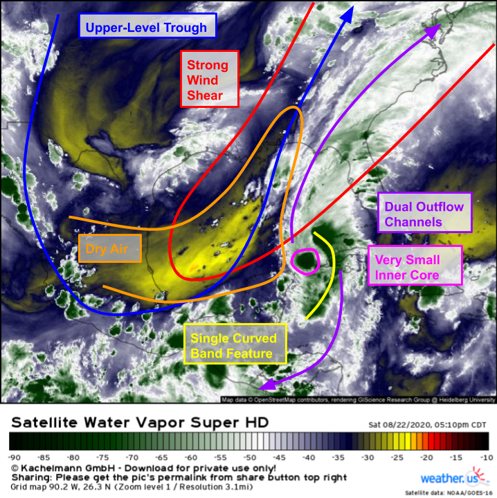 Here’s a look at Marco placed within its larger environmental context via WV satellite imagery. The system’s core is extremely small, perhaps only 50 or 100 miles across, and it is attempting to maintain a single curved band to the east of its center. This structure is favorable for rapid fluctuations in intensity both upward and downward. We saw quick intensification this morning which paused a bit this afternoon. Intensification may pick up again tonight/tomorrow, or the system may quickly weaken at any point. There are two forces pushing Marco towards increased intensity: warm water and excellent jet-level venting of warm outflow both north and south away from the core. These impulses towards strengthening are offset by dry air entrainment and southwesterly wind shear associated with the upper-level trough over the western Gulf of Mexico.
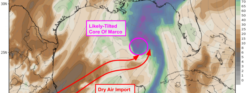
 This ECMWF forecast for mid-level relative humidity tomorrow afternoon shows a clear path for dry air associated with that trough to infiltrate Marco’s core. That dry air will be brought into the system by the SW winds we’ve been talking about. Without the shear, the storm would be able to fend off the dry air by mixing it out and creating its own envelope of moisture-rich air. Similarly, if there weren’t any dry air to worry about, the storm could probably fend off the shear by maintaining deep convection over its center. However, when the storm has to deal with both at once, it has a much harder time remaining intact.
With that in mind, while I thought there was significant upside risk for Marco’s intensity when it was down in the Caribbean, I think there is somewhat significant downside risk for Marco’s intensity in the Gulf of Mexico. That should not change what actions you take to prepare for the storm if you live along the Gulf Coast. One reason is that obviously the storm could (and more likely than not will) make landfall as a hurricane and you should be prepared for that possibility even if it’s not 100% certain. The second reason is a bit unique to this situation: even if Marco fizzles out before arriving in Louisiana, Laura is barely 48 hours behind. So even if Marco looks like it’s struggling tomorrow, prepare like it’s going to arrive as a hurricane and you’ll be ready for Laura on Wednesday.
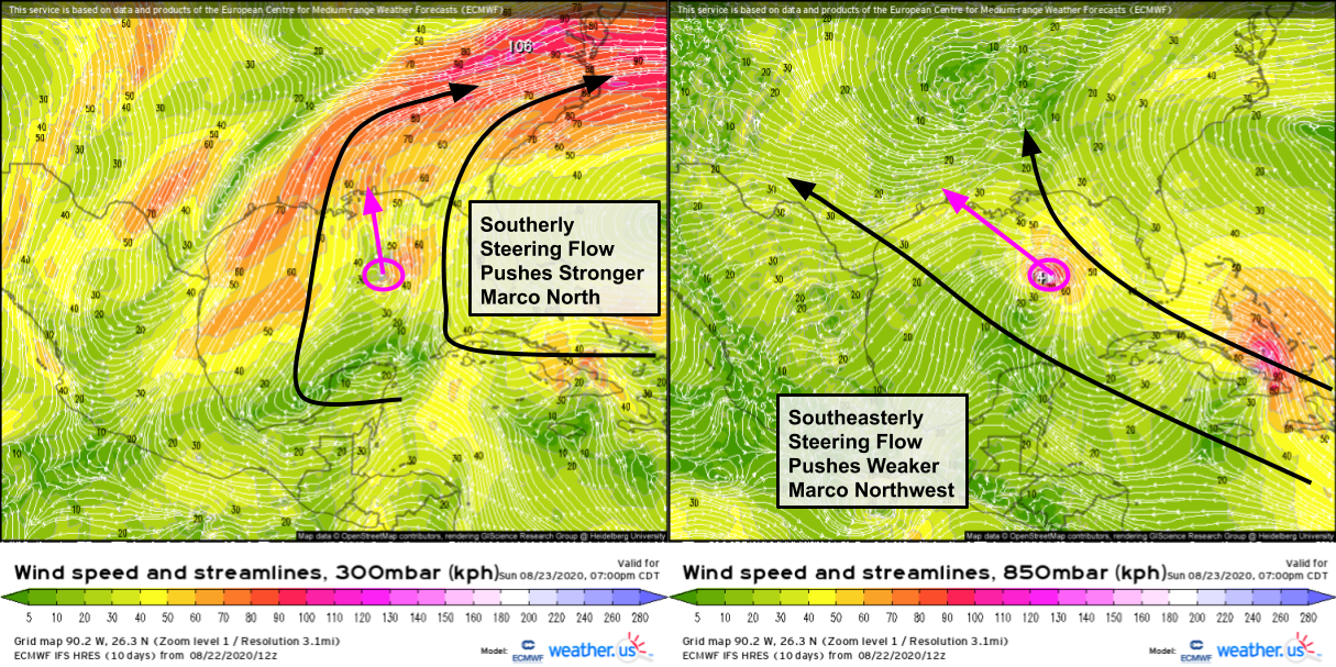
Marco’s track will be determined in large part by its intensity tonight and tomorrow. A comparison of wind forecasts for the upper atmosphere (300mb) which would steer a stronger storm with wind forecasts for the lower atmosphere (850mb) which would steer a weaker system shows that the stronger Marco gets, the more it will track north rather than northwest. If it were to intensify into a hurricane, that means landfall in SE Louisiana or the panhandles of MS/AL. If it were to remain a moderate/strong tropical storm, that means landfall in west/central Louisiana. If it were to weaken into a weak tropical storm or tropical depression, that means landfall farther west in southeastern Texas would be on the table.
So what might Marco look like when it gets to Louisiana on Monday? Let’s take a look using 850mb wind forecasts (in kph!) to avoid too much focus on various model surface friction algorithms and the temptation to see a number over your town and think that forecast is a done deal.
First and foremost, it will be small. The storm is small now and it won’t have time to grow significantly before arriving on land. So a stronger scenario would look something like the ECMWF forecast shown here. A very narrow swath of SE Louisiana would see the potential for hurricane-force winds while a much wider swath of the state would experience tropical storm force gusts. New Orleans honestly could go either way (TS-force or hurricane-force winds) depending on how exactly the storm wobbles.
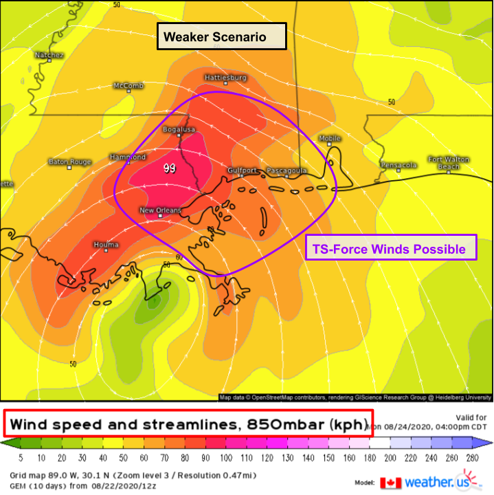 A weaker scenario would look more like this forecast by the Canadian model which expects tropical storm-force winds over southern MS and adjacent parts of SE LA but no hurricane-force winds even where the center makes landfall. The model shows a similar landfall point as the stronger ECMWF forecast because it shows weakening only right as the storm approaches the shore. Either way, as the system weakens due to land interaction, it will turn to the west and should end up dissipating near the TX/LA border by Tuesday/Wednesday.
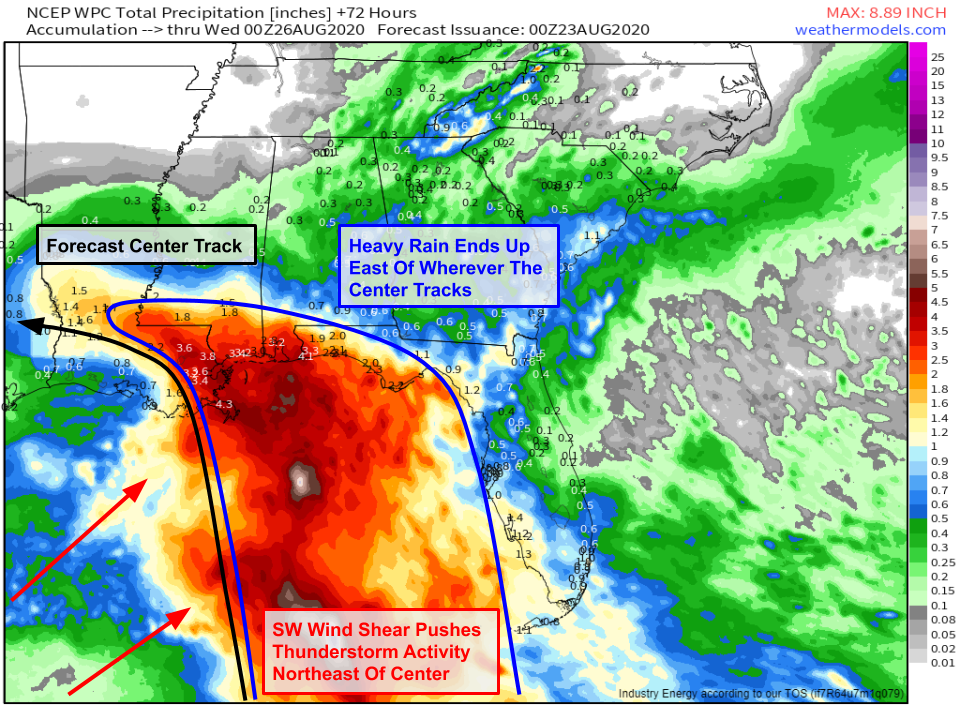 As far as rainfall goes, the forecast shown here from the WPC shows heavy rainfall concentrated east of the storm’s center. This makes sense given the southwesterly wind shear we’ve been discussing. When a tropical cyclone’s thunderstorm activity gets pushed off to one side of the system by wind shear, the heavy rain and strong winds go with it. Thankfully from a flooding perspective, Marco will be relatively fast-moving. rainfall totals east of the center in LA/MS/AL should be roughly 3-6″ with locally higher totals possible. That will put water in the usual low-lying spots but shouldn’t cause major widespread issues.
It’s also important to note that as the storm comes onshore, it will produce several feet of storm surge mostly to the east of its point of landfall. Much like the system’s rain, this surge will cause issues in the usual spots and outside the levee system but should not be extreme enough to cause widespread problems. Please familiarize yourself with your location’s risk of storm surge if you haven’t already and make sure you’re taking precautionary actions appropriate to your area.
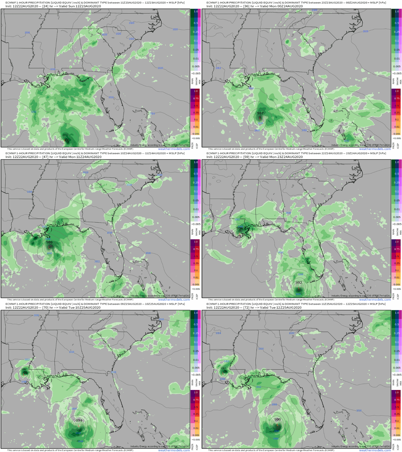 To close out this post, here’s a loop of the ECMWF hourly forecast showing the system fluctuating in intensity as it approaches the Louisiana coastline before weakening and turning west once onshore. Behind it is Laura which will be the subject of blog discussions tomorrow.
-Jack
