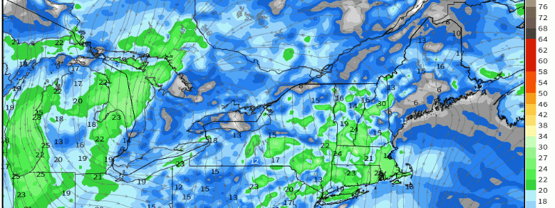
Isaias Trying To Reorganize East Of Florida, Still Expected To Bring Heavy Rain And Gusty Winds To Much Of The East Coast
Hello everyone!
The past 24-36 hours have been a period of watching and waiting for Isaias to either succumb to the dry air and shear we’ve seen plaguing it over the past few days or start to rebuild its inner core. After it looked like the system might fizzle out entirely yesterday morning (it completely lacked deep thunderstorm activity for several hours after passing over Andros Island in the Bahamas), Isaias has been firing some impressively intense convection as it moves slowly north off Florida’s East Coast. As a result of staying a bit stronger than guidance expected, the storm has avoided making landfall in Florida. The storm is now set to begin its turn to the northeast ahead of an advancing upper-level trough over the Central US. This post will take an updated look at the storm’s forecast for the remainder of its journey up the Eastern Seaboard over the first part of the upcoming week.
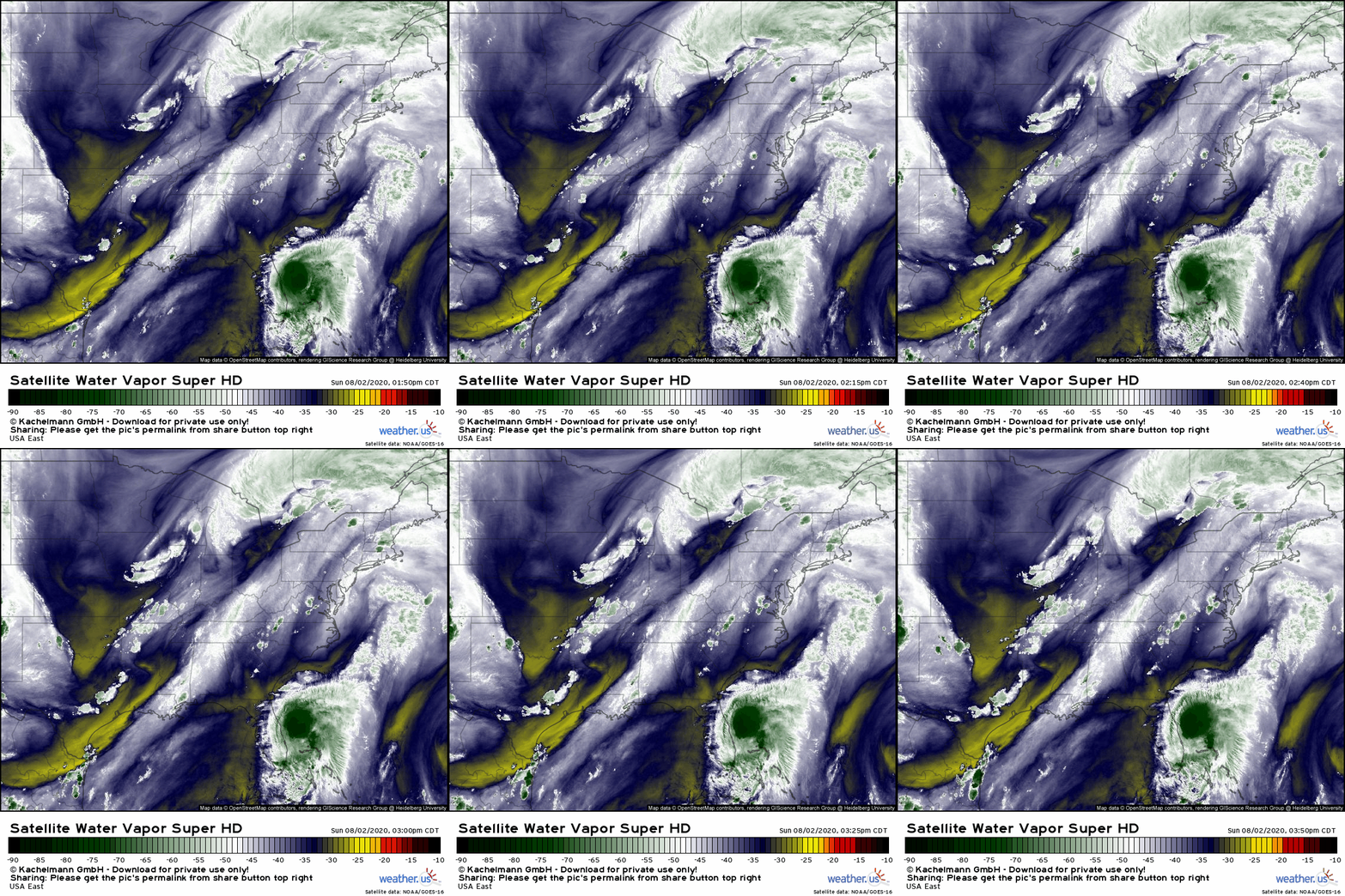 The aforementioned trough is clearly visible on GOES-East WV imagery this evening. You can see the northwesterly flow behind the trough axis over the Plains and the southwesterly flow ahead of the trough axis extending from the western Gulf of Mexico up the Appalachians. Isaias is just a few hours from starting to “feel” that southwesterly flow and adjust its course towards the north-northeast rather than its current north-northwest heading. As the storm makes this turn, it won’t “feel” nearly as much wind shear. Remember that shear interrupts tropical cyclones by pushing thunderstorm activity away from the center. When the “shear” is pushing the thunderstorms to the northeast at 20kts tomorrow, and the center is also moving to the northeast at 20kts tomorrow, the thunderstorms will remain oriented properly relative to the center. So the storm will be effectively feeling very little shear.
 The waters between the east coast of Florida and the Carolina coast are quite warm and will absolutely be supportive of strengthening. Remember that tropical cyclones need sea surface temperatures of roughly 26C to thrive. Anything above 27-28C is supportive of a major hurricane (if all other environmental factors align). Water temps in the path of Isaias are currently running a little above 29C. So there will be plenty of fuel for Isaias to strengthen if it can get its inner core in line.
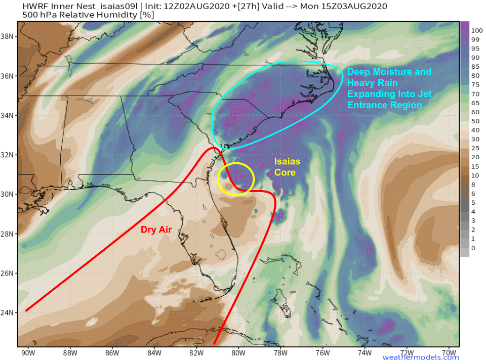 Forecasts from the high-resolution HWRF model suggest that even as the shear environment improves surrounding Isaias tomorrow morning, and as it moves over very warm water, it will remain constrained by dry air to its south/southwest. As has been the case all weekend, if the cyclone can close off an inner core, it will be able to fight off this dry air fairly well. If not, it will continue to struggle. At the moment, given the storm’s history and the environment through which it’s moving, I’m leaning in favor of a weaker open core with Isaias. I’d put the odds of a Carolina landfall roughly at its current intensity (+/- 5 mph) at about 80%. However, there is a small (but definitely nonzero!) chance that the storm will be able to close off an inner core once the shear relaxes a bit. In that case, it would have about 12 hours to quickly strengthen before landfall in southern NC or northern SC. I’d set the upper limit of this scenario at 100 mph if everything goes perfectly for Isaias. Again, it’s not what’s likely to happen, but it’s a possibility you should be thinking about and prepared for if you’re on the coast in northeastern SC or southern NC.
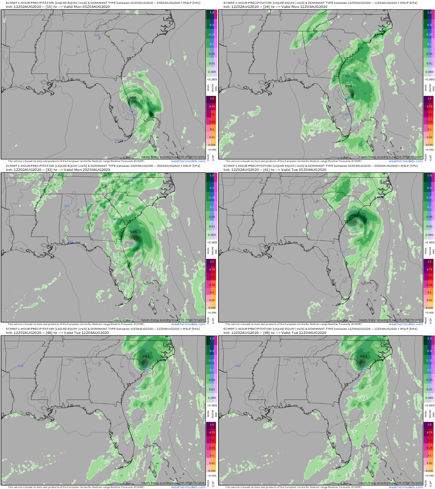 The ECMWF is hinting at this higher-end scenario with landfall as a category 1 hurricane in far NE SC early Tuesday morning. The official NHC forecast is expecting landfall as a 70 mph tropical storm, though hurricane watches are posted for portions of SC and NC where hurricane force winds remain a distinct possibility. With that said, I’d urge you to resist the temptation to become invested in figuring out whether this will make landfall as a hurricane or a tropical storm. It’s honestly a coin flip at this point between 70 mph TS and 75-80 mph hurricane. Odds are you won’t find yourself in the very small part of the storm (NE eyewall) producing these winds, and odds are that even if you are, you won’t notice a difference between 70 mph winds and 75 mph winds. Prepare for some tree damage and power outages, secure loose items in your yard that could become projectiles if winds pick up, and follow any other instructions given by local officials.
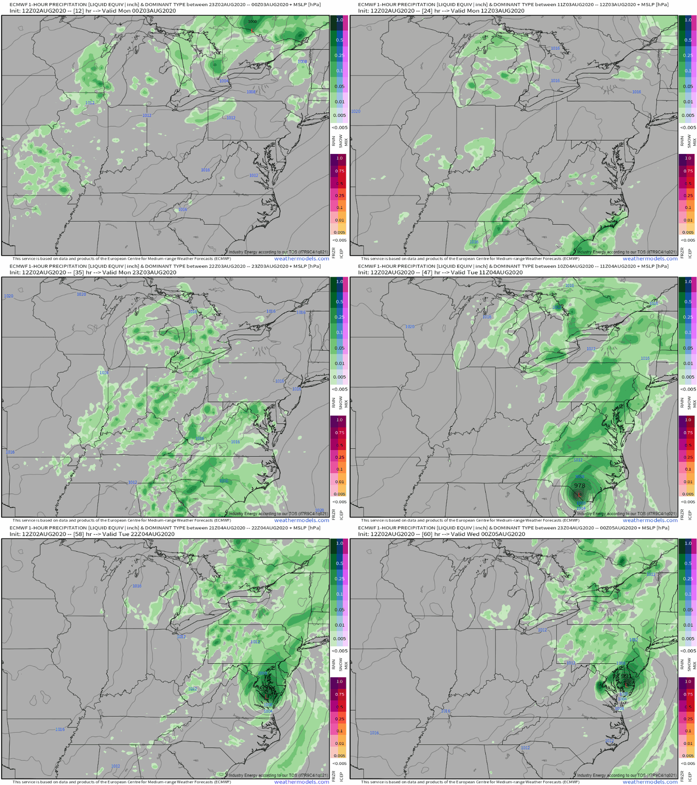 Regardless of what the core of Isaias is doing (that only really matters if you’re in its relatively narrow path from near the NC/SC state line up towards Chesapeake Bay), heavy rain will break out over North and South Carolina by tomorrow morning. The rain will continue in these as the storm passes through on Tuesday, and will rapidly spread up the coast as the jet streak we’ve been discussing for several days gets set up. Rain will fall quite heavily even in places that are hundreds of miles from the storm’s center. Flash flooding impacts will arrive first, followed by responses on larger streams and rivers.
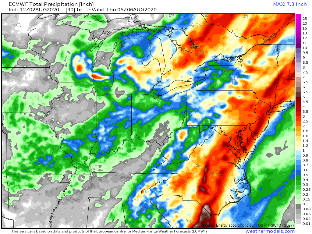 The heavy rain forecast remains entirely unchanged from previous days, despite the uncertainty regarding the intensity and precise track of the storm’s core. A widespread swath of 2-5″ of rain will fall from coastal SC up into western NC then up the coastal plain (east of the Appalachians) all the way to Maine. Within that swath, there will inevitably be towns that pick up considerably more rain (up to 8-10″) due to randomly-placed favorable convective interactions. If your area is susceptible to flooding in heavy rain events, you should be prepared for high water.
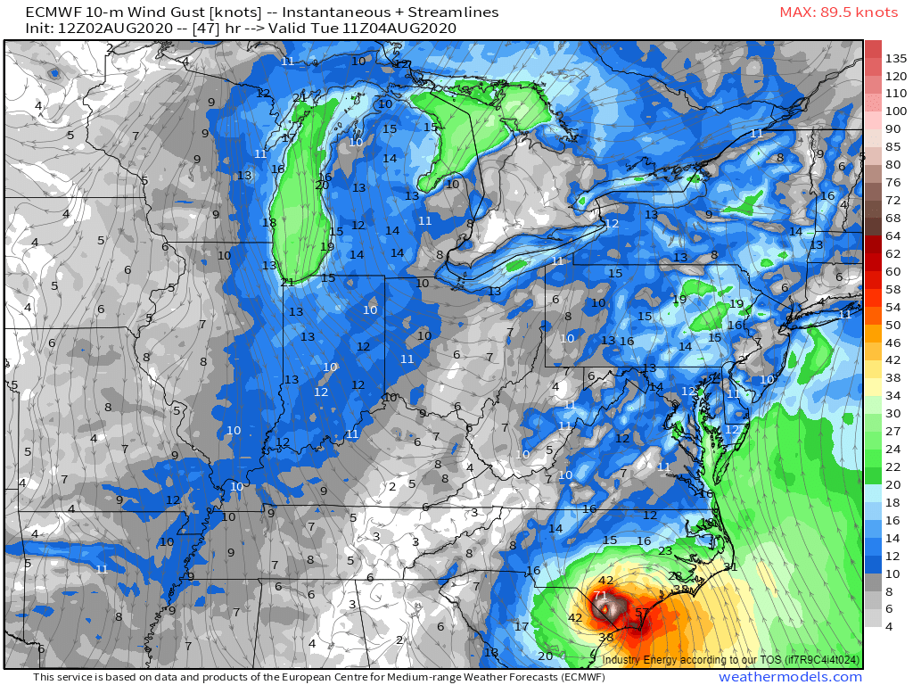 As the storm comes ashore, regardless of the maximum wind speed in the eyewall, onshore winds will pick up to the east of the center. This means that much of southern NC including the Outer Banks and the Pamlico Sound area will have to worry about storm surge. Current NHC forecast guidance expects a peak surge of 2-4 feet in this region. If your area is especially prone to surge flooding, now would be a good time to think about what preparations you need to complete in the next 24 hours to keep you, your family, and your property safe.
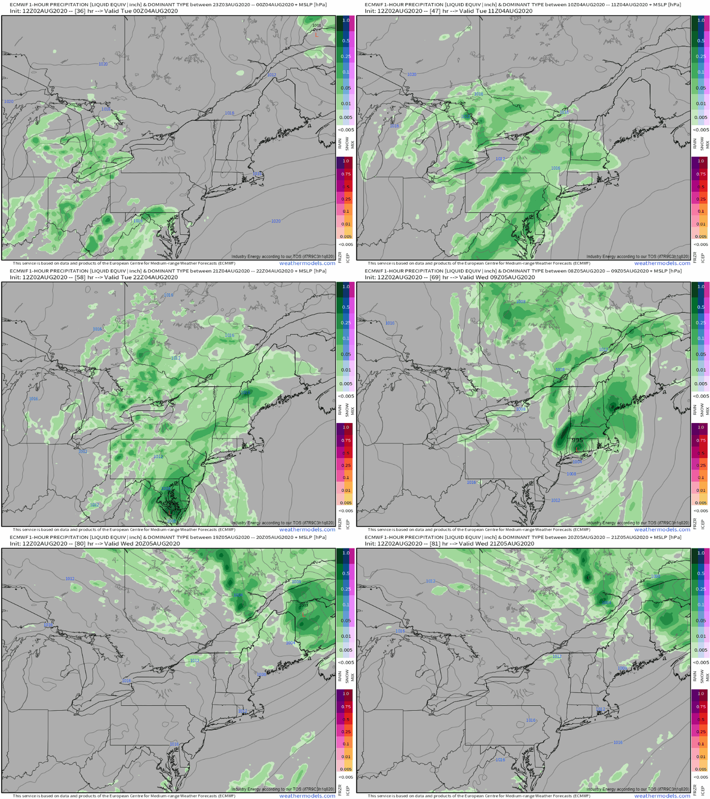 Isaias will rapidly accelerate northeast on Tuesday, moving through the northern Mid Atlantic and towards southern New England by Wednesday morning. Rain will fall heavily at times even well ahead of the storm’s center. Rainfall totals in this area will be similar to those forecast farther south: a general 2-5″ with localized totals exceeding 8″.
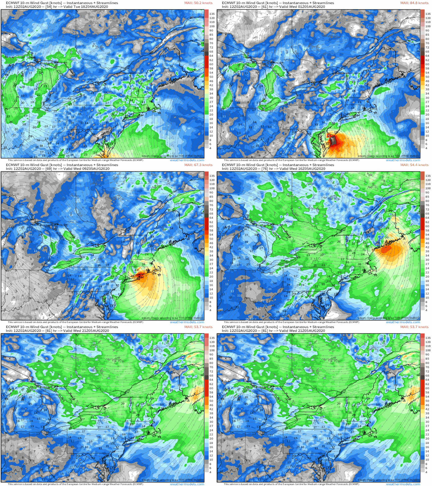 The storm’s gusty winds will be focused along the coastline east of the center’s track. As Isaias moves northeast, mostly over land, it will lose its source of fuel: warm water. Usually, tropical cyclones fall apart rapidly after they move inland. The boost Isaias will enjoy from the upward motion in the right-entrance region of the jet streak responsible for all the rain will keep its winds up a bit longer than they might otherwise be if the storm was moving inland without that support. Beach towns from the Delmarva to Cape Cod should be prepared for 50-65 mph gusts that could cause some tree damage and power interruptions. Just inland and along the northern New England coastline (ME/NH), gusts will be a bit lower (40-55 mph) but still capable of isolated tree/power issues. If you’re west of the storm’s track (west of I-95 for the sake of broad-brush outlines), you won’t have to worry about winds. Heavy rain will be focused to the west of the track, especially as the system moves into New England. In fact, most of Cape Cod will likely wind up with less than an inch of rain from Isaias!
By Wednesday afternoon, Isaias will be little more than a fading cluster of showers over Canada. What’s next in the tropical Atlantic you ask? Tomorrow’s weekly tropical weather discussion video will focus on the next disturbance to watch, 94L, as well as when to expect a break in TC activity, and when we could start to get a lot busier.
-Jack


