Isaias Still Struggling With Dry Air And Shear This Morning, Heavy Rain Remains The Primary Threat For The East Coast
Hello everyone!
Hurricane Isaias continues moving slowly northwest this morning. The latest advisory from the National Hurricane Center indicates that the storm’s maximum sustained winds are now up to 85 mph while its minimum central pressure is down to 988mb. This represents just a bit of strengthening since yesterday. That’s impressive given the hostile environment the system has been fending off in terms of both dry air and wind shear. This post will take a look at both the storm’s forecast meteorologically-speaking as well as tweaks to the impact forecast presented last night. The main messages remain more or less unchanged since that last update: Isaias will recurve up the East Coast as a slowly-weakening system with the primary threat being widespread very heavy rain.
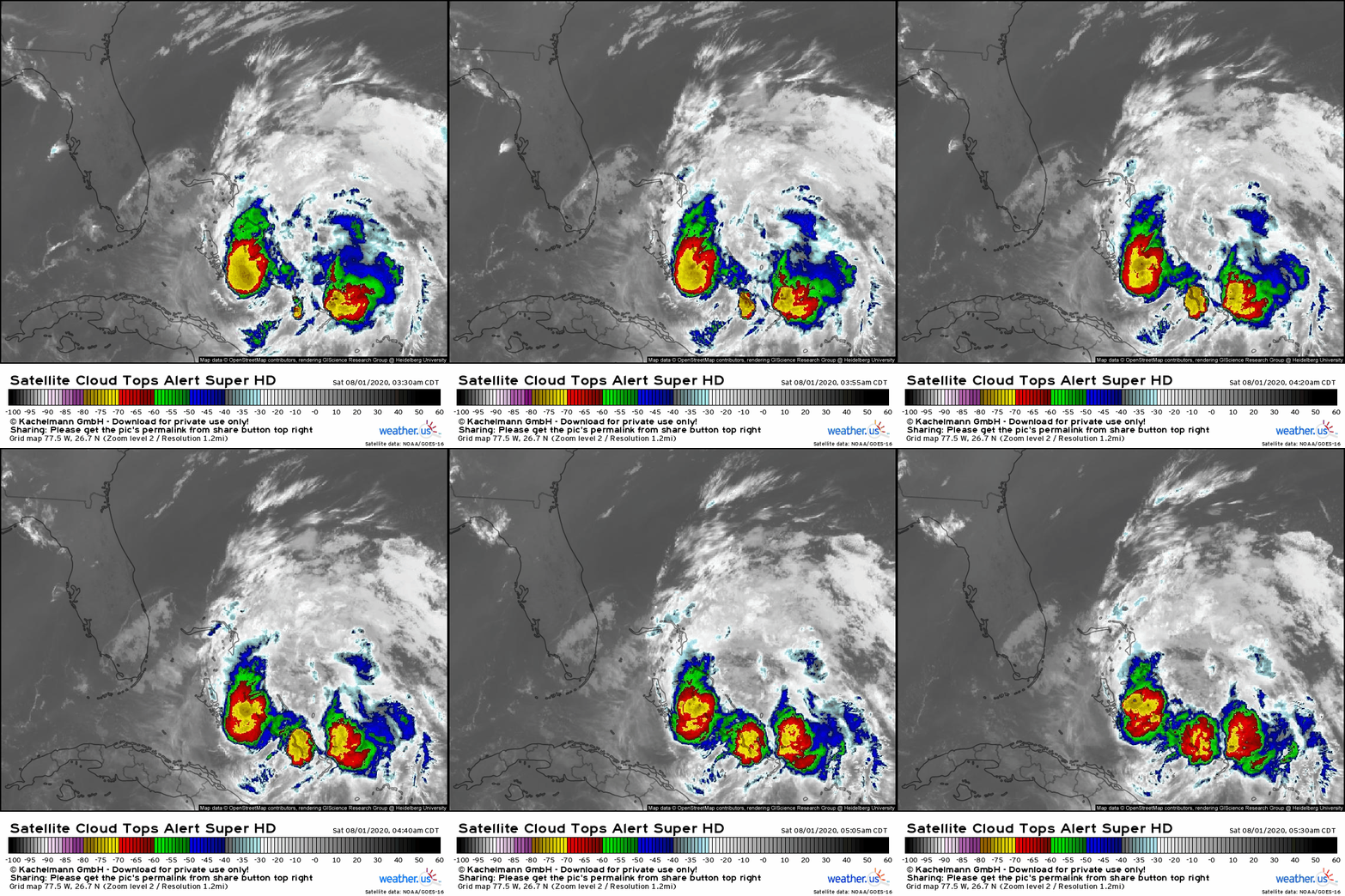 Isaias hardly looks spectacular on satellite imagery this morning. The storm has been able to maintain deep convection near its center, but the strongest updrafts remain northeast of the center. Additionally, convective activity outside the CDO (Central Dense Overcast- the region of intense storms surrounding the center) has been fairly limited, even on the eastern side of the storm where conditions are generally more favorable for favorable for thunderstorm development. Tracking the movement of cirrus clouds surrounding the storm indicates that it is building a nice outflow channel to the north/northeast as well as to the south. That said, the impact of the westerly/southwesterly wind shear remains clearly evident this morning. The storm’s western side is devoid of any convective activity, and there are no cirrus clouds racing out to the west of the storm’s center.
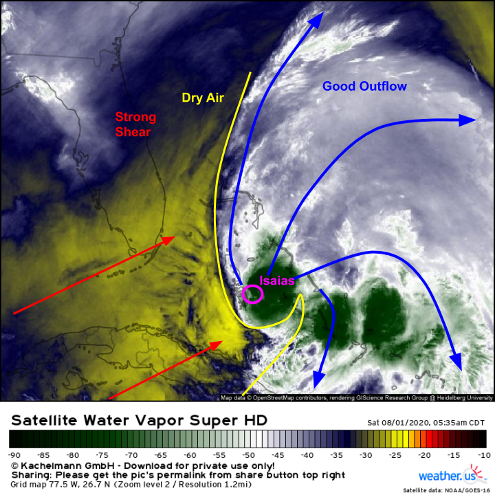 Water vapor imagery is helpful in putting a finer point on the storm’s structure and environment. Here we see the center of Isaias located at the far western edge of the storm’s favorable (ish) envelope. Strong WSW wind shear is pushing dry air into the center, and restricting the western extent of that favorable envelope. The storm has so far mostly been fighting the dry air and shear to a draw. The storm would like to wrap its convection all the way around the center and expand that favorable envelope back to the west so it can intensify. The shear would like to push the storm’s thunderstorm activity so far to the northeast that the circulation elongates to the point where it falls apart. So far, neither has happened, and the storm has remained more or less in a steady state. One last note is the northward expansion of that “good outflow/favorable moisture” plume. On longer satellite loops (too big to embed here, but you can see them at weather.us), you can see this plume reaching up to the north-northwest over the last 12 hours. This is a sign that the process of funneling tropical moisture northward has begun. For folks in eastern Florida and perhaps parts of eastern North Carolina, the core of Isaias will be the most impactful storm. For everyone else, all eyes are on that plume of tropical moisture and the persistent heavy rain bands it will support.
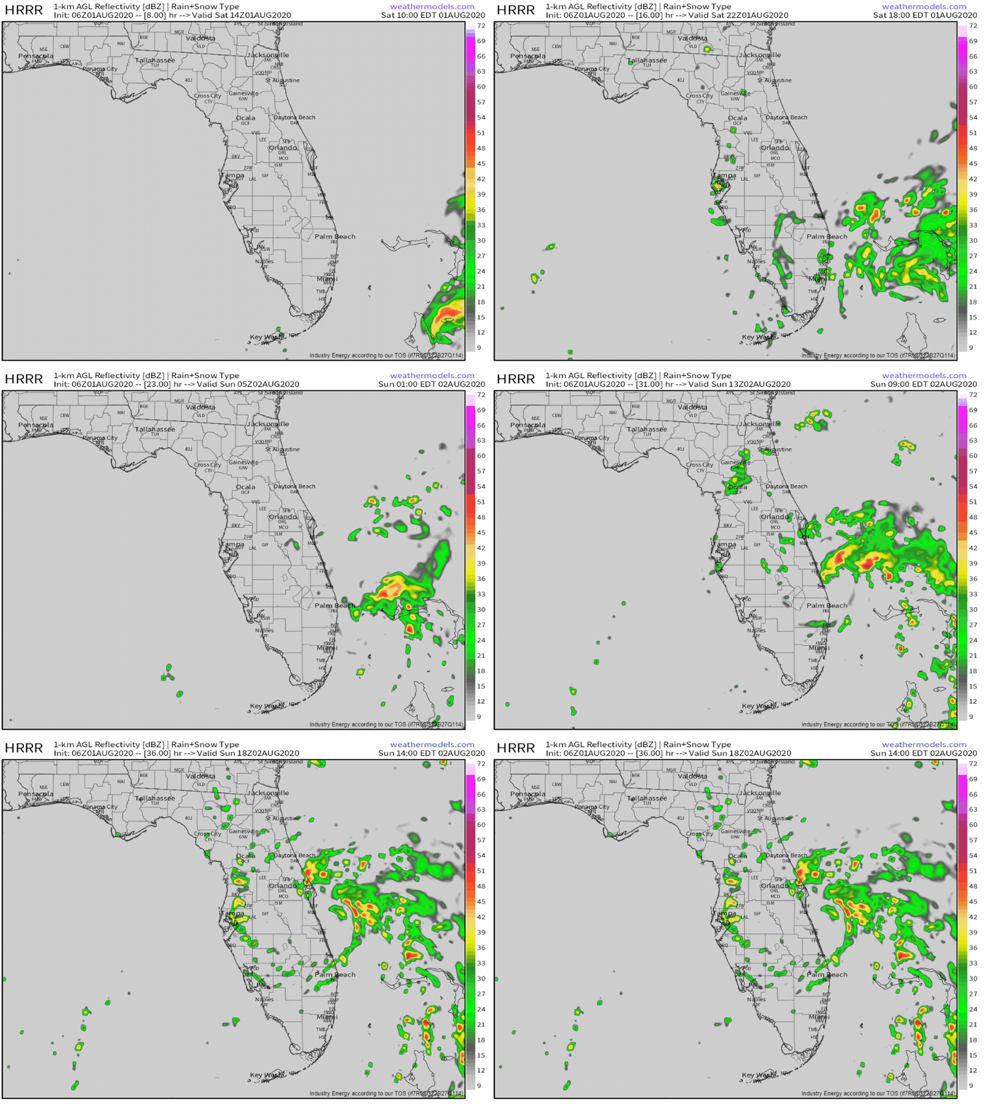 Impacts from Isaias will arrive in Florida later today as the storm moves in the general direction of West Palm Beach. The HRRR’s simulated radar forecast might not be the best way to show impacts from the system’s core (depending on the extent to which the core is able to remain intact in the face of the dry air/shear) but I think it’s picking up on the outer bands fairly well. Squalls from Isaias will arrive in Florida later this morning and will impact the entire state (save perhaps for far western areas) as the storm moves north tonight and tomorrow. Squalls will bring brief bursts of heavy rain and gusty winds along with the potential for a tornado.
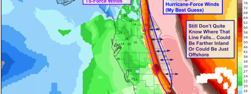
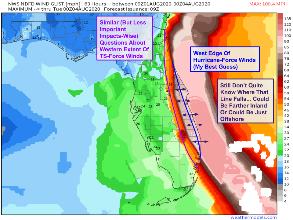 The most severe impacts to Florida from Isaias are expected along the state’s eastern coastline which will be closest to the core of the storm. Last night’s NWS forecast update brough the western edge of expected hurricane-force wind gusts farther inland. I’m not sure I fully agree with that as most guidance that showed Isaias making landfall in Florida had it much weaker than it is now. So far, the storm seems to be holding onto some semblance of an inner core and as a result will tend to move a bit farther east than model guidance from yesterday anticipated. So I’m still sticking with the idea yesterday that if you’re within say 10 or 15 miles of the coastline in the Hurricane-Warned area, you should be prepped for hurricane-force winds. Otherwise, TS-force winds are much more likely. The exact western extent of hurricane-force winds will of course depend on the exact wobbles of the storm’s eyewall (and the existence of such an eyewall). It’s entirely possible that the storm falls apart between now and when it arrives in Florida and is only capable of bringing TS-force winds to the coastline. It’s also possible that the storm wobbles farther east and hurricane-force winds remain offshore.
Based on overnight trends both in forecast guidance and the storm’s evolution as observed by satellite imagery, I don’t think Isaias will move very far inland over Florida (if it does so at all). As a result, the storm has the opportunity to retain some of its inner-core if it can continue fending off the dry air and shear plaguing it this morning.
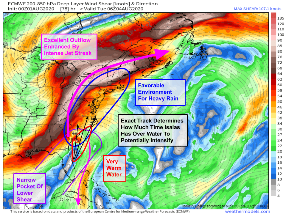
This slight eastward nudge to the track opens the door for some more significant wind/surge impacts in the Carolinas if the storm doesn’t succumb to the shear and surge over the next couple days. After passing Cape Canaveral, Isaias will be turned to the north and northeast by an approaching trough over the Mississippi River. Depending on how soon that turn happens and exactly what path the storm takes between Florida and the Carolinas, it could have up to 18-24 hours over the extremely warm waters of the Gulf Stream to intensify before making landfall. Of course to take advantage of these warm waters, the storm would need some sort of inner core and it would need a brief respite from dry air and shear.
While there will still be dry air to the west of the storm, shear will be quickly decreasing as the storm turns and accelerates northeast. This is mostly because storms feel shear relative to their forward motion. Right now, Isaias is moving NW into a wall of W/SW winds. So it’s feeling a lot more shear than if it were moving ESE. Remember that shear disrupts a hurricane by moving its thunderstorm activity to the wrong side of the storm. If the center is moving in the same direction as the shear, this can’t happen. For example, on Monday night, southwesterly shear will attempt to push Isaias’ thunderstorm activity to the northeast of the center. But the center will also be racing northeast, chasing after the “displaced” storms! So relative to the center, the storms won’t really be displaced much. Finally, the storm will be in the hallowed right jet entrance region we’ve been talking about being so key for heavy rain. The reason the right entrance region is so helpful for producing heavy rain is that it promotes northward moisture transport as well as upward motion. So thunderstorms developing near the center of Isaias will get a boost from this non-tropical upward motion in addition to the upward motion associated with the cyclone itself.
All that to say that if (big if!) Isaias can hold onto part of its inner core over the next 48 hours, ends up sliding just east of Florida rather than heading inland, and tracks a little farther east than current guidance shows, it could have a brief window to reintensify before arriving in the Carolinas. Whether or not this happens is important for residents along the NC and SC coast (and perhaps Cape Cod) but for everyone else, it will do nothing to change the forecast for the most impactful part of Isaias’ journey up the East Coast which will be the heavy rain produced by its interaction with that jet streak.
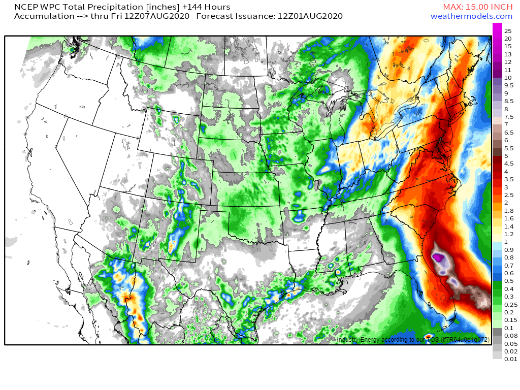 Here’s the latest rainfall forecast from the WPC’s mix of model guidance and human forecaster input. The swath of heavy rain attributable to Isaias extending from Florida to Maine is clearly evident. Within that area, most spots will pick up a solid 2-5″ of rain with isolated towns pushing well above that. Downsloping northwest of the Appalachians will mark the northwestern edge of the heavier rainfall swath. If your area is prone to flooding in very heavy rain events, you should start to think about preparing for high water.
I’ll be doing a livestream update on our @WeatherdotUS periscope channel this afternoon at 4 PM EDT to discuss the latest updates to the storm’s forecast. Tune in to get the latest info and ask any questions you might have about the storm as it moves up the East Coast over the next several days. I’ll have more updates on twitter before then: @WeatherdotUS and @JackSillin.
-Jack
