92L Becomes PTC 9 East Of Barbados, Likely To Become Isaias Tonight Or Tomorrow
Hello everyone!
The system we’ve been watching in the deep tropical Atlantic, known as 92L, has now been dubbed Potential Tropical Cyclone (PTC) 9 by the NHC. The potential tropical cyclone designation means that the system has not yet met the relevant criteria to become a tropical cyclone, but is likely to do so in the future, and will bring impacts commensurate with those associated with a tropical cyclone to land areas. This allows for the issuance of tropical-cyclone-related watch/warning products before the system is officially deemed a tropical cyclone. The forecast for 92L has been the subject of much discussion here, on twitter, and in the wider meteorological community in recent days. This post will present the latest forecast information as of this afternoon while still keeping in mind that there are many uncertainties in this system’s forecast that have yet to be resolved.
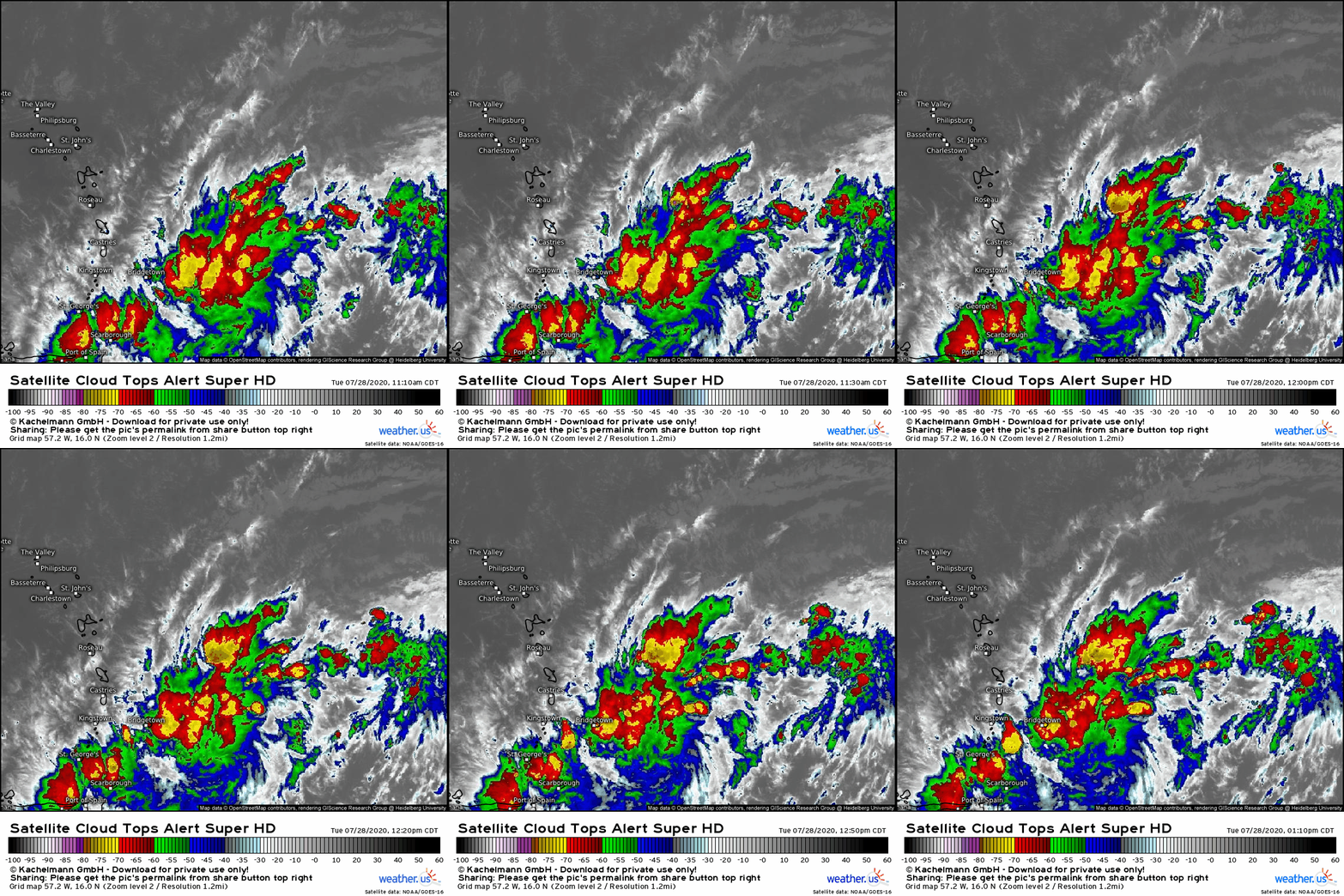 We’ll start, as per usual, with a look at the system on satellite imagery. Convective activity associated with the system has drastically increased since yesterday, as was expected once it entered a region where sea surface temperatures were considerably warmer. Instead of a few showers that had cloud tops near -50 or -60C, we now have widespread thunderstorms with cloud temps between -70 and -80C. That is a huge improvement for the system as it tries to establish a coherent center of circulation by releasing latent heat into the atmosphere by way of this convection. That latent heat release is ultimately the engine that drives the pressure falls and winds we associated with tropical cyclones. Also noted on satellite imagery this afternoon is unimpeded cirrus outflow both to the north and south of the storm’s incipient center, located a bit ENE of Barbados. This is evidence of an upper-level anticyclone developing above the storm which helps with ventilation of air away from the storm center in the upper-levels. This ventilation process “makes room” for more air to rise through the atmosphere into this region from the lower atmosphere, and is consequently an important process for supporting tropical cyclone development. It’s also evidence that the system is not dealing with any wind-shear related issues which means it will be easier for consolidation of thunderstorm activity to occur.
So what’s next for PTC 9? That’s the million dollar question isn’t it. We’re quickly approaching what I highlighted on Sunday as “inflection point one” where the storm would either head north or south of (or perhaps right over) the Greater Antilles. This morning, I was tempted to think that the southern track was more likely because thunderstorm activity was consolidating around the southwestern portion of the system’s trough axis. If the center formed farther southwest, it would stand to reason that the system as a whole would be more likely to track farther south. That said, I think the development of the center farther southwest along the trough axis is also helping the system develop more quickly because it’s located over warmer waters and in a more favorable position relative to shear and dry air (mostly north of the system). I alluded in Sunday’s update to the dependence of PTC 9’s track on its intensity, especially over the next couple days. Let’s take a closer look at why exactly that’s the case.
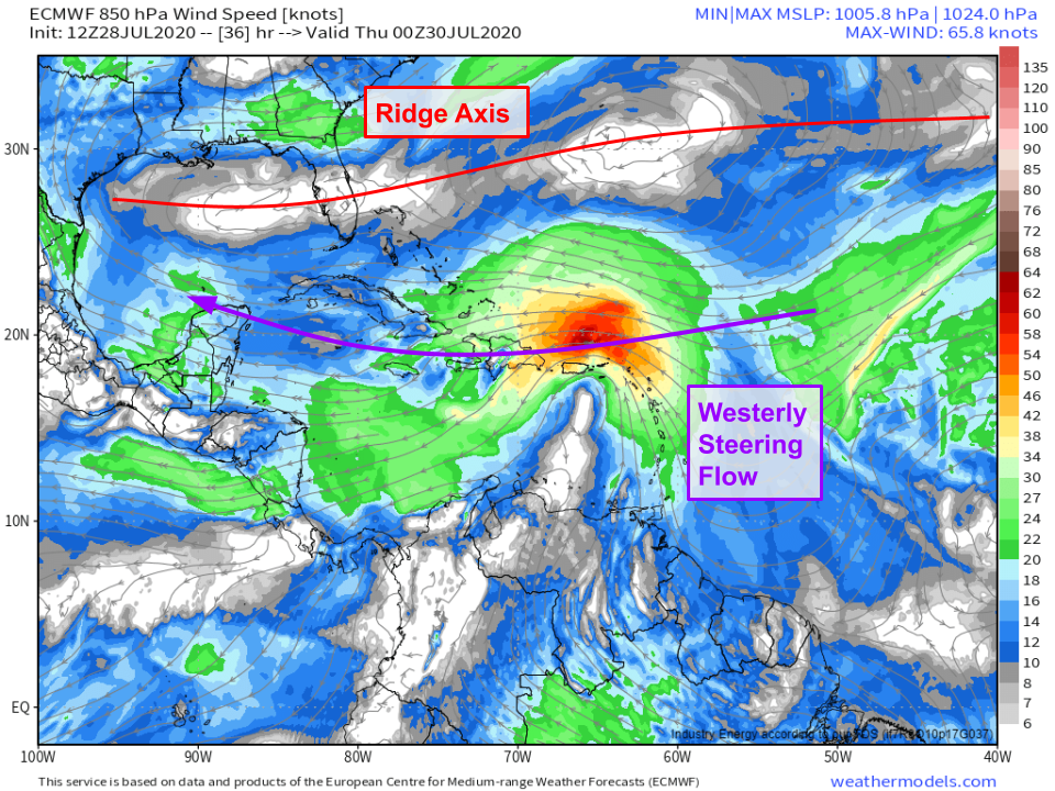
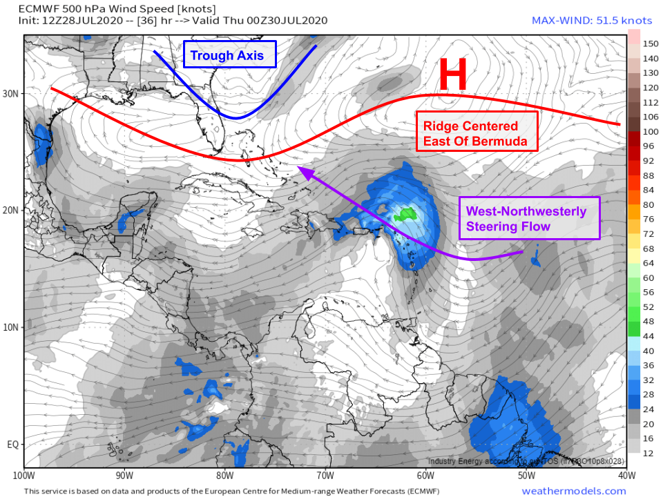
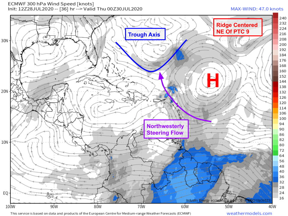
The key idea to understand when exploring this relationship between intensity and track is that stronger cyclones “feel” steering features higher in the atmosphere. By analyzing what steering features exist at various levels within the atmosphere, we can get a pretty good idea of where a weak storm might track relative to a strong storm.
A weak system will feel steering currents around 850mb fairly strongly. In the case of PTC 9 tomorrow, the 850mb layer is steering the storm almost due west towards Hispaniola. This is because in this layer, the ridge primarily responsible for steering the storm is located mostly west-east and is centered due north of the storm (near Bermuda). So if PTC 9 remains weak over the next 36 hours (tropical wave or TS/weak TD), it would likely slide due west into Hispaniola. This solution would cut down on the potential for significant US impacts, though the wave would still be a risk for development in the Gulf of Mexico after it emerges from Cuba in a few days. For what it’s worth, today’s run of the ECMWF is depicting this solution with tropical cyclone development from PTC 9 not occurring until the system arrives in the Gulf of Mexico in roughly a week.
If the storm were a little stronger (medium/strong TS or perhaps weak hurricane), it would “feel” steering features in the 500mb layer. This means a track a bit more to the west-northwest. Note that the ridge is centered farther east (now ESE of Bermuda rather than due S) and a trough axis (“weakness” in the ridge that tropical cyclones like to head towards) over the Bahamas. This is what I’d consider to be the most likely solution. It is also what the NHC is showing in its official forecast. This track would take PTC 9 near or over Puerto Rico and the far western edge of Hispaniola before moving into the southeastern Bahamas. If this track were to occur, even a small wobble (driven by smaller-scale processes that are essentially impossible to predict) would bring the storm onshore in Hispaniola, severely disrupting its circulation.
If the storm were to intensify much more than expected (into a hurricane), it would be steered by the 300mb layer. I don’t think this is likely, or even really plausible, but I show it to illustrate the general trend that as you head higher into the atmosphere, the steering ridge center shifts farther southeast and thus the steering flow has a progressively stronger southerly component (steering the storm more towards the north).
Setting aside for now the possibility that PTC 9 continues moving west through Hispaniola/Cuba as a tropical wave or weak tropical depression/storm, we’ll investigate what might be waiting for the system in the southwestern Atlantic (should it make it that far). This isn’t because I find the possibility of the southern/weaker track less likely, but more because it’s clearer what would happen in that scenario (much lower odds of substantial US impacts, at least within the next week).
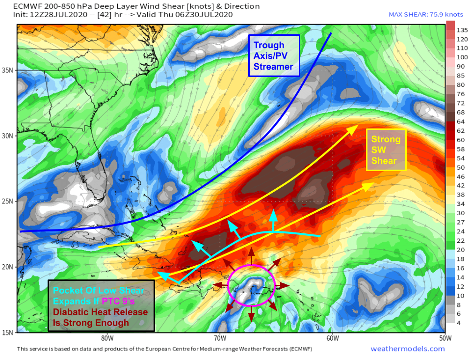
If PTC 9 were to dodge landfall in the Dominican Republic, its next hurdle would be a wall of southwesterly wind shear on the southeastern flank of a potential vorticity streamer (PVS) extending from Bermuda down towards Cancun. If PTC 9 is relatively weak (moderate/strong TS, remember now we’ve moved our reference frame because if the storm is north of Hispaniola, it’s already a moderate/strong TS), it is likely to be more or less shredded by this wind shear. The remnant wave might redevelop later, but the storm would be toast at least for a little while. However, stronger storms (hurricanes) have a defense mechanism for situations like this. A hurricane can create its own little envelope of lower shear by releasing tremendous amounts of heat and moisture into the upper atmosphere. Remember from Sunday’s blog and yesterday’s video that PV streamers are regions of cool/dry air in the upper-levels. A hurricane can blast right through one of these features by clearing a path for itself using its own upper-level outflow. At the moment, I think PTC 9 could do this if it really starts rapidly intensifying over the next 12-18 hours. I do not think this is the most likely outcome. As of right now, the model guidance favoring such an outcome includes the parallel GFS v16 (new version currently being tested) and the HWRF. I’m not well-versed in how the new GFS handles tropical cyclones, but the HWRF does have a tendency to overdo a system’s rapid intensification (such as it did by consistently forecasting rapid intensification of Gonzalo into a major hurricane when it actually dissipated).
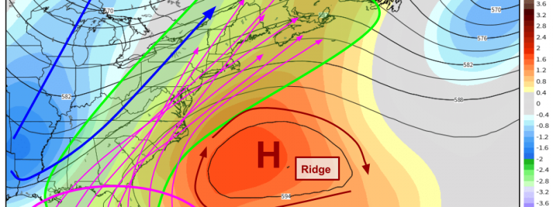
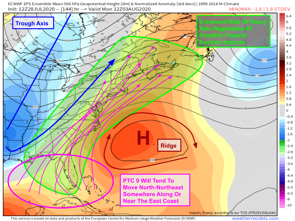 Regardless of how strong PTC 9 is when it arrives in the SW Atlantic – Bahamas – Florida – Eastern Gulf of Mexico region, the synoptic pattern over eastern North America by the end of the weekend will send the system north/northeast up the East Coast. This might be as a tropical storm with modest rain and wind, it might be as a disturbance with locally heavy rains and nothing else, or it might be a stronger system with more impacts. I think this is an unusual situation where forecast confidence (in the track at least) increases later in the forecast period. Regardless of whether the system is over the Gulf or over the Bahamas, by Monday it will be headed north-northeast. Of course it’s way too early to figure out exactly where it’s headed, but that will be the general trajectory so long as this synoptic pattern exists with a strong ridge near Bermuda to block the storm from recurving out to sea.
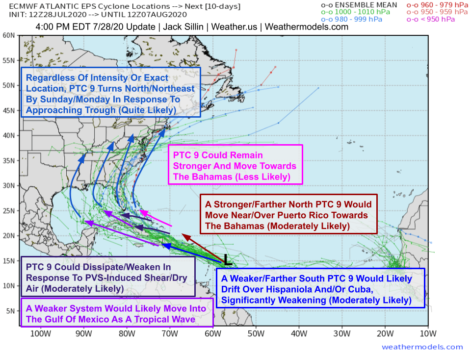
Here’s what all that looks like in the format that seems to have helped folks make sense of uncertainty in tropical cyclone forecasts. The 12z EPS envelope shifted quite a bit to the south, with very few if any members taking the system north of Hispaniola. I’m not fully convinced this is off the table yet, pending convective trends in the near term which could set PTC 9 on a path towards quicker intensification and a track more northwesterly than west-northwesterly.
More updates to come over the next few days as the forecast becomes clearer. At the moment, I’d advise folks in Florida to begin following forecasts closely and start thinking about what preparations they might need to make later this week if it becomes likely that a tropical storm is headed their way. At the moment, I think the odds of PTC 9 becoming a major hurricane threat to Florida or other parts of the US is nonzero but relatively small. We’ll of course keep an eye out in case that changes.
-Jack
