Invest 98L To Bring Heavy Rain To Parts of the East Coast Tomorrow and Saturday
Hello everyone!
While we still don’t have any powerful hurricanes to watch in the Atlantic, a disturbance off the North Carolina coastline (dubbed 98L by the National Hurricane Center) will bring heavy rain to parts of the East Coast as it moves north over the next couple days. This blog post will discuss this system’s odds of development and its expected impacts. For a broader look at the tropical Atlantic this week, please refer to Monday’s tropical weather discussion video.
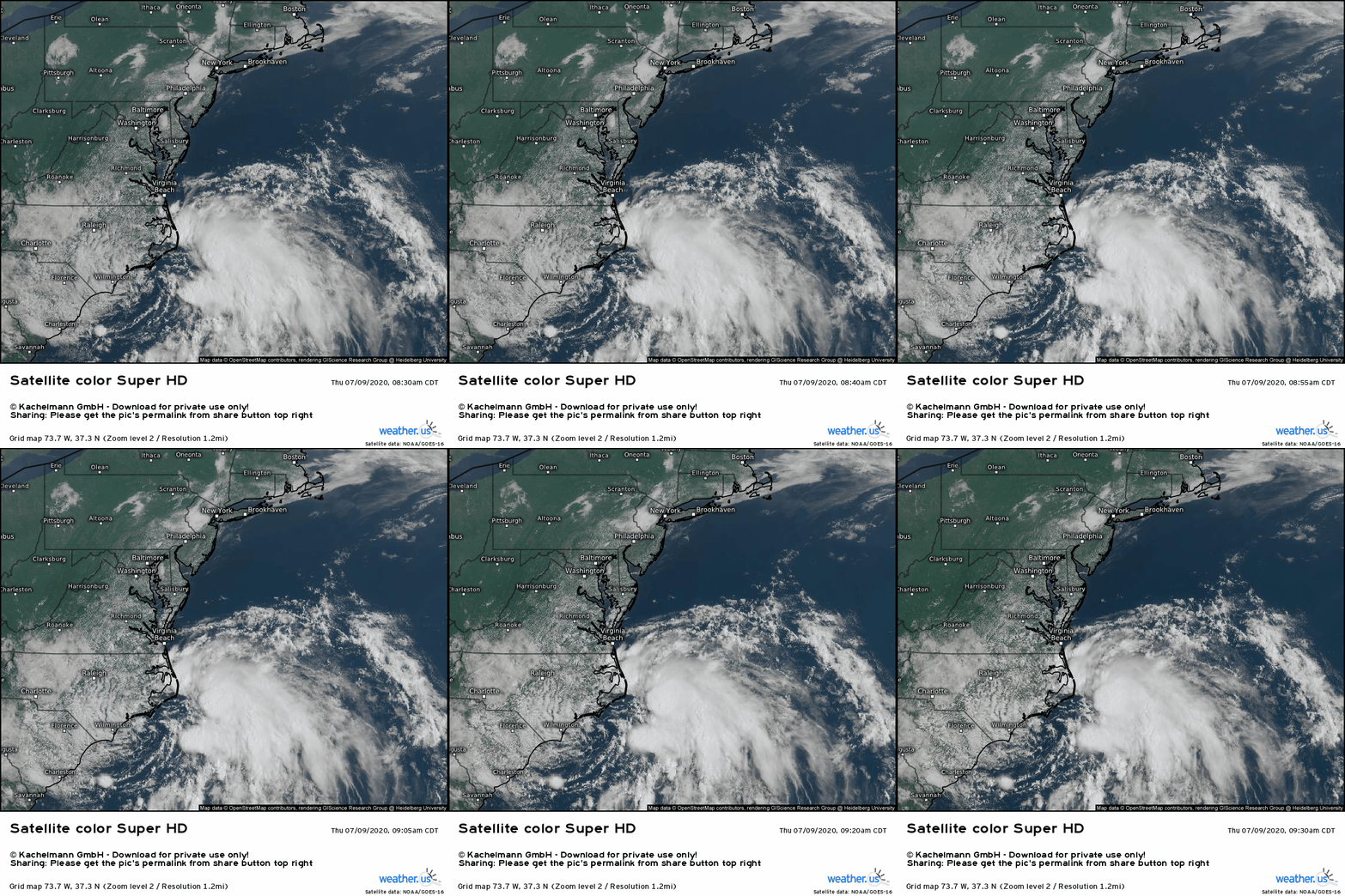
Satellite imagery of the system shows a low-level center of circulation located just east of Wilmington NC. The shower and thunderstorm activity associated with the system meanwhile is displaced well east of that low-level center. Until the low-level center and the shower/thunderstorm activity end up in the same place, this system is unlikely to be deemed a tropical cyclone by the NHC. The most likely pathway for such a rendezvous would be for the low-level center to relocate underneath the thunderstorm cluster. This could happen because inside the thunderstorms, air is rapidly rising and latent heat is being released into the atmosphere as water vapor condenses. The net result of both of these processes is a reduction in the surface pressure beneath the thunderstorms. If these storms remain strong enough and persist for the rest of today and tonight, we could very well see a center relocation by tomorrow morning.
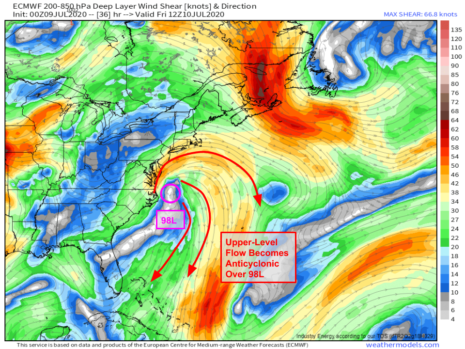
This process will also be aided by a reduction in wind shear over the system. Currently, strong westerly winds aloft are pushing shower and thunderstorm activity east of the center (this explains the pattern we see on satellite imagery this morning).
By tomorrow morning, that westerly shear will have given way to a more favorable shear configuration for tropical cyclone intensification as winds spiral away from 98L in a clockwise pattern. This “upper-level anticyclone” will help thunderstorms continue to develop as 98L moves north-northeast.
As far as the system’s track goes, the forecast is fairly straightforward. Winds through most of the atmosphere will be coming from the southwest over the East Coast tomorrow between an incoming trough over the Great Lakes and a subtropical ridge southeast of Bermuda. A small extension of that ridge over the Gulf of Maine will kick 98L a little more towards the north than northeast. The storm will head for Long Island by Friday night and will be dissipating over Quebec by Saturday afternoon.
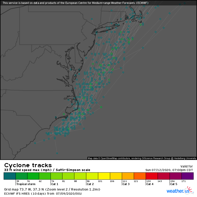
EPS cyclone tracks confirm the relative certainty regarding the track forecast for 98L. The only question remaining is exactly where the system’s center comes ashore in southern New England. This will determine which towns will see the heaviest rain (3″+ instead of 1-2″) but otherwise it’s a moot point. Because 98L doesn’t have much time to develop and will be moving over relatively cool waters starting tonight, it won’t have much wind associated with its center. A few beach towns may gust to 40-50 mph but aside from widely scattered power outages, there won’t be much in the way of impacts associated with this system’s winds.
WPC precipitation forecasts (intentionally broad-brushed to not try to pinpoint individual thunderstorm cells) show a widespread 1-3″ rain event incoming from the Delmarva through eastern PA/NY into New England. This region has been relatively dry so far this spring/summer and this will be a welcome soaking. A few small streams will rise to near bankful but no major flooding issues are expected. Localized spots with poor drainage will likely be briefly full of water as the heavier rain swings through Friday night, so be careful in the typical low-lying urban spots if you’re out and about.
98L will dissipate over Canada by Sunday, though it’s hot and humid airmass will remain firmly in place across the East Coast heading into next week.
-Jack


