Tropical Cyclones 101: Anatomy Of A Hurricane
Hello everyone!
The 2020 Atlantic Hurricane Season is now officially underway (as of June 1st) which means that it’s a great time to brush up on your knowledge of tropical cyclones. The more familiar you are with these systems and how they work, the better prepared you’ll be to follow along with forecast discussions when a tropical cyclone approaches the coastline. This is the fourth in a several-part series (“Tropical Cyclones 101”) aimed at bringing everyone up to speed on what tropical cyclones are, how they work, and how you should prepare for their impacts. This post will discuss the anatomy of a mature (fully-formed) hurricane.
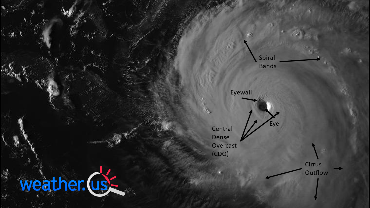
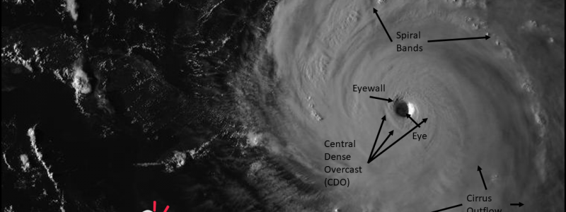
This satellite image shows a classic example of a mature hurricane. The vast majority of strong (category 3+) storms will look very similar to this, and they will all have some variation of the features highlighted here. The most obvious feature of course is the storm’s clear eye. Almost all hurricanes (except a few category one storms) have eyes. The more circular and well-defined the eye is, the stronger the hurricane. Why is there a patch of clear skies at the center of a raging hurricane? We know that air in the eye descends, but it’s a little less clear exactly why. One of the more plausible ideas is that an atmospheric pileup of sorts occurs near the top of the eyewall where air is rapidly rising. Too much air is trying to occupy too small of a space near the top of the atmosphere in this region, so some of it must depart. Most of this departure occurs horizontally and is known as the storm’s outflow. You can see this process by watching the wispy cirrus clouds fan out away from the storm’s center in a generally clockwise (anticyclonic) pattern. However, this horizontal outflow is not enough to resolve our atmospheric pileup, and some of the air then sinks back towards the surface, warming and drying as it does so (hence the calm eye).
Surrounding the eye is the storm’s eyewall, which is the most intense innermost ring of thunderstorms. This is where the storm’s strongest winds are found. In a strong storm, the eyewall is a completely closed-off ring of thunderstorms, but in weaker storms, the eyewall may be partially open. The eyewall marks the inner boundary of the storm’s Central Dense Overcast (CDO) which is a region of dense convection (thunderstorm activity) that surrounds the storm’s core. This part of the storm isn’t quite as intense as the eyewall, but still packs ferocious winds and torrential rain. Outside the CDO is the fringes of the storm which take the form of spiral bands. These are long and narrow bands of thunderstorms may pack briefly strong winds, but lack the sustained ferocity of the storm’s inner core. The bigger threats from spiral bands (also referred to as spiral bands) are heavy rain and tornadoes.
Of course every hurricane is unique and no two storms will look or behave exactly alike. However, if you look at satellite images and other observations of strong hurricanes, you’ll see each of these features appear over and over again. For the purposes of illustrating these features, I used satellite imagery from a Category 5 storm because it provided the most “textbook” example of each feature. Less-powerful storms are often less-well organized, so if you go looking for an eye/eyewall in a category one storm, you may be disappointed not to find it easily on satellite imagery. Sometimes the eye and eyewall do exist, but are only visible on radar imagery because the sinking motion in the eye isn’t strong enough to break a hole in the CDO. I’ll take a closer look at the anatomy of these weaker storms later in this series.
-Jack
