Tropical Cyclones 101: What Exactly Is A Tropical Cyclone?
Hello everyone!
The 2020 Atlantic Hurricane Season is now officially underway (as of June 1st) which means that it’s a great time to brush up on your knowledge of tropical cyclones. The more familiar you are with these systems and how they work, the better prepared you’ll be to follow along with forecast discussions when a tropical cyclone approaches the coastline. This is the first in a several-part series (“Tropical Cyclones 101”) aimed at bringing everyone up to speed on what tropical cyclones are, how they work, and how you should prepare for their impacts. In this post, I’ll discuss what makes tropical cyclones different from other types of storms.
A tropical cyclone is officially defined as a warm-core, non-frontal cyclone originating over tropical or subtropical waters which derives its energy from organized deep convection and has a closed surface wind circulation around a well-defined center. That definition is packed with a lot of jargon, so let’s take a closer look at each criteria, starting with “warm core”.
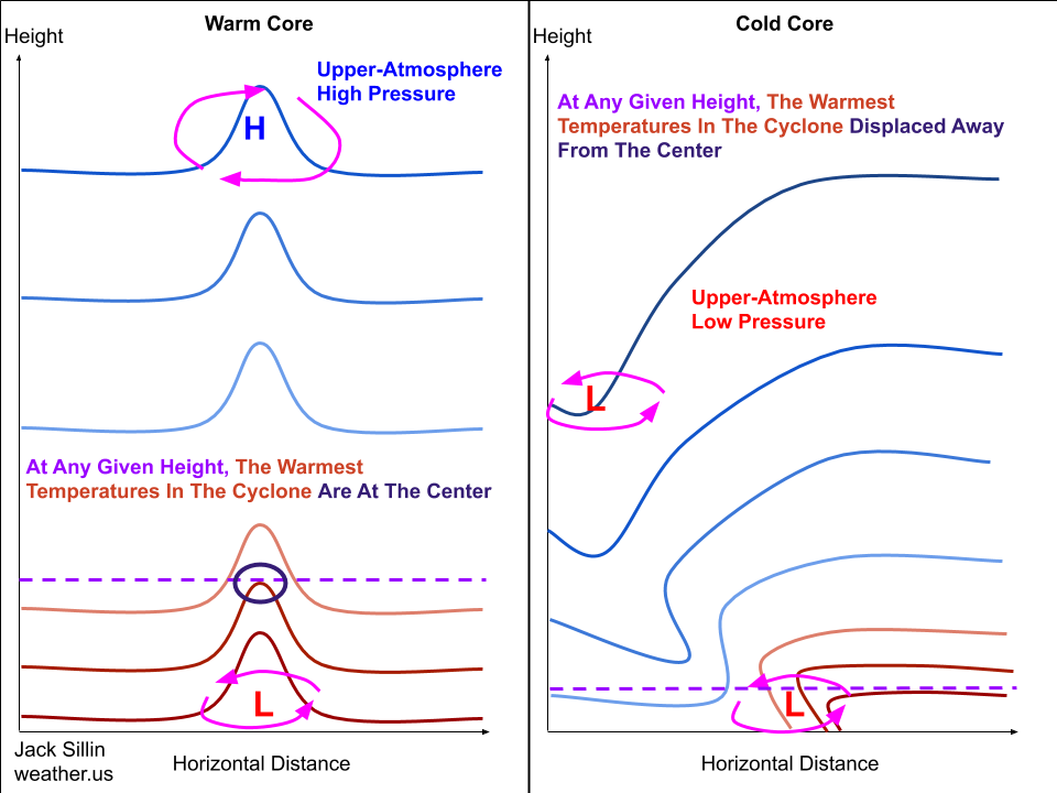 A cyclone is considered warm core if the storm’s center represents a local temperature maximum. In other words, if you were to measure the temperature at many points throughout the storm and found that your warmest readings occurred near the storm’s center, you’d be dealing with a warm-core cyclone. The schematic cross-section on the left illustrates such a system. Interestingly, a warm-core cyclone is not associated with low pressure near the top of the troposphere (the lowest layer of the Earth’s atmosphere where most of the weather that affects us occurs). The warm air near the storm’s center actually supports an upper-level high pressure system that’s located atop the lower-atmosphere cyclone. This upper-level anticyclone (just another way of saying “high pressure”) turns out to be a crucial part of the engine that keeps tropical cyclones running (I’ll discuss this process in more detail in later parts of this series).
Now that we know how a warm-core cyclone is different from a cold-core cyclone, lets examine the next part of the definition of a tropical cyclone: “non-frontal”.
 A storm is deemed non-frontal if it has no fronts associated with its circulation. As you might recall, a front is a boundary between two airmasses where surface pressure reaches a local minimum and the temperature gradient reaches a local maximum. Non-tropical cyclones (like Nor’easters for example) are fueled by clashing airmasses, which mean they have fronts associated with them. These fronts mean that the pressure and temperature gradients associated with a frontal cyclone are asymmetric about the storm’s center. If you head northwest from an extratropical low, you’ll typically find a much more rapid increase in pressure than if you head east or northeast (along the warm front). This is not the case for tropical cyclones, which must have temperature and pressure gradients symmetric about the storm’s center. That means that no matter which way you head from the storm’s center, you should find (roughly) the same pressure and temperature gradient. Why is this definition important? Sometimes extremely strong extratropical cyclones can actually become warm-core cyclones when a portion of the warm air southeast of the storm gets cut off from the rest of the warm sector. These “warm-seclusion” cyclones can be extremely impactful, but they are not tropical cyclones. Thus we need the “non-frontal” definition to make sure we’re not including those systems as tropical cyclones.
The next part of the definition (“originating over tropical or subtropical waters”) is actually the loosest criteria applied to tropical cyclones, depending on how you define what it means to “originate”. Most of the disturbances that are “seeds” for tropical cyclone development actually begin life over land, either as clusters of thunderstorms over western/central Africa or frontal boundaries sinking south from the North American continent. In fact, there have been a few rare cases where the National Hurricane Center (NHC) has named storms while they were still technically centered over far western Africa. Either way, to be a tropical cyclone, a storm must spend the vast majority of its life over tropical or subtropical waters (any ocean/bay/sea with water temperatures above 26C).
The next part of the definition (“which derives its energy from organized deep convection”) says that to be a tropical cyclone, a system must be powered by organized thunderstorm activity. We know from basic physics that energy can neither be created nor destroyed, but only transformed from one form to another. To get the kinetic energy (wind) we associate with cyclones, we need some source of potential energy from which to draw. For extratropical cyclones, this source of energy is the thermal gradient between warm and cold airmasses. For tropical cyclones, this source of energy is the release of latent heat associated with the condensation that occurs inside thunderstorms. As water vapor condenses in the thunderstorm updrafts, latent heat is released, which warms the air temperature (this is why tropical cyclones are warm-core systems). This warm air wants to rise (hence its place in the updraft of strong thunderstorms) until it reaches the tropopause, at which point it races away from the storm’s center (remember there’s a high pressure center in the upper-levels, around which air circulates clockwise while diverging away from the center of the high). This leaves a deficit of air (low-pressure area) near the bottom of the atmosphere where the storm’s center is, which is the driving force behind the winds observed with tropical cyclones.
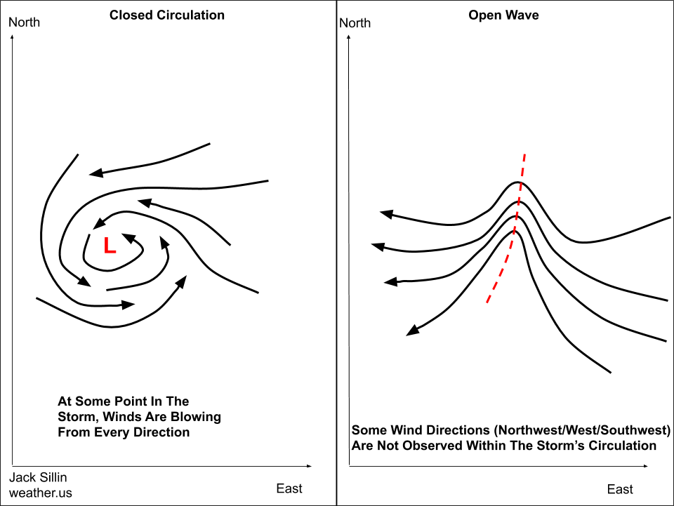
Finally, to be a tropical cyclone, a system must have a closed center of circulation.
That means that you need to be able to go to at least one place in the storm and find the winds blowing from every direction. You need to be able to find an easterly wind somewhere (usually this is quite easy since tropical cyclones often develop within the easterly Trade Winds), a northerly wind somewhere, a southerly wind somewhere, and a westerly wind somewhere (usually this is quite hard to find in developing TC’s because the circulation needs to become strong enough to reverse the trade winds). If any of those wind directions is lacking, the storm is referred to as an “open wave” or axis of shifting winds that has not yet closed off a circulation.
Once all the above criteria are met, the system counts as a tropical cyclone. It’s at this point that we can give it a designation and, if applicable, a name. I’ll cover the classification and naming scheme for tropical cyclones in my next TC 101 post.
-Jack
