Another Round of Significant Severe Weather is Likely Across the Deep South Tomorrow
Hello everyone!
Another outbreak of significant severe weather is in the forecast for parts of the Deep South tomorrow as low pressure develops in the Red River valley along the Texas/Oklahoma border. Ahead of that low, southerly winds will push warm moist air into the region from the Gulf of Mexico while strengthening winds aloft lead to increased wind shear. The combination of instability supported by that warm/moist Gulf air, the wind shear supported by strong winds aloft, and forcing along the system’s warm and cold fronts will make tomorrow another dangerous day for severe weather with impacts from all severe hazards (hail/wind/tornadoes) likely. This post will explore the threat from this system and will take a closer look at both what to expect and some of the meteorology that explains why.
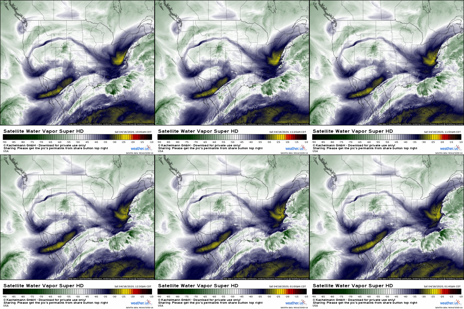
GOES-East satellite imagery from this afternoon shows a few features that will be key to tomorrow’s forecast. First, note the upper level disturbance moving through southern California. This is the disturbance that will be responsible for the formation of the low that will set the stage for severe storms. Rising motion ahead of that trough is already slowly beginning to drive pressure falls over northern Texas which is beginning the process of northward moisture advection farther southeast. A warm frontal boundary has begun to take shape at the leading edge of that deeper moisture and is producing some shower and thunderstorm activity in southern Louisiana and southeastern Texas this afternoon. The final ingredient easily visible on WV imagery is a plume of dry air moving northeast off the Mexican desert. That mid-level warm/dry airmass will help storms develop robust updrafts and prevent too many storms from forming at once during the late morning hours.
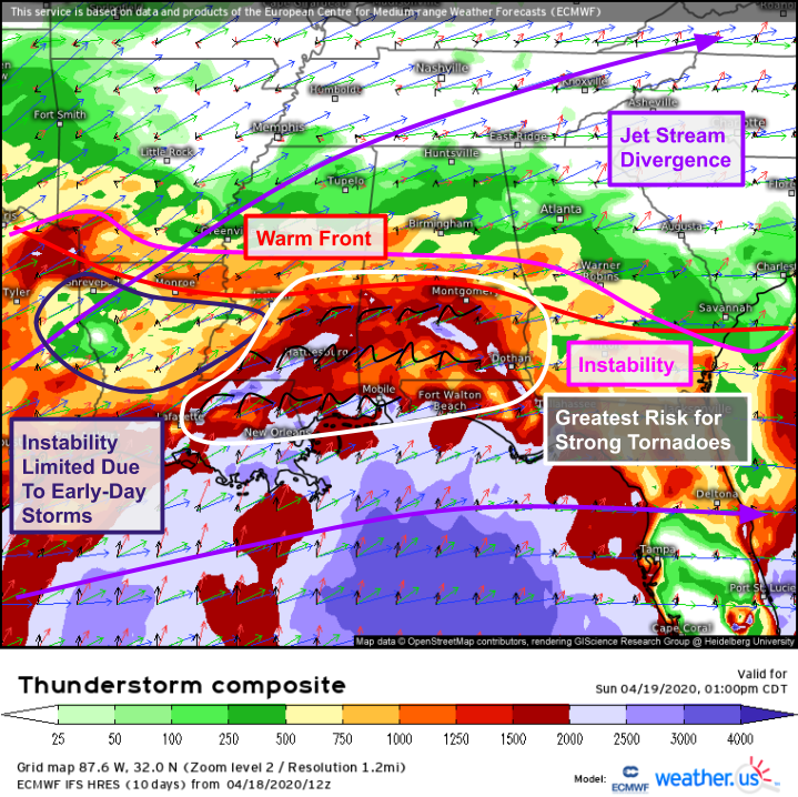
Here’s a look at ECMWF Thunderstorm Composite guidance for tomorrow afternoon. Instability should be no problem especially over southern parts of Mississippi and Alabama as well as eastern Louisiana and far western parts of the Florida panhandle. CAPE values >500 J/kg (supportive for marginal severe weather given sufficient shear and lifting) are forecast as far north as the Greenville MS – Birmingham AL – Atlanta GA corridor. Shear isn’t crazy impressive but should be robust enough to get the job done. It should be noted that shear profiles are more supportive of supercells over southern parts of the risk area (generally highlighted in white) while linear modes are favored farther north. One wild card will be the extent to which thunderstorm activity in progress during the morning hours (leftover from tonight’s storms in Texas) will limit available instability in northern Louisiana. If these storms are weaker than expected, or more limited in coverage, northern Louisiana could also be looking at significant severe weather. At the moment, it’s hard to say which outcome is more likely as the storms in question are just starting to pop up near Houston.
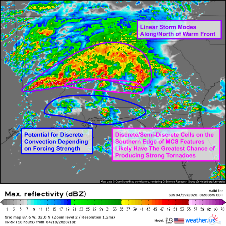
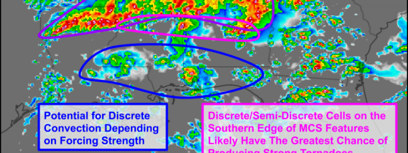
HRRR simulated radar guidance valid a bit later in the afternoon adds confidence to the forecast outlined above using the thunderstorm composite data. Most of northern LA/MS/AL/GA will experience tomorrow’s severe weather in the form of repeated rounds of linear storms. The biggest threats in this region will be flash flooding, damaging winds, and tornadoes embedded within the line. Farther south, storm modes have a better chance of being discrete or semi-discrete. Any supercells that form along the I-20 corridor in MS or adjacent parts of AL could produce strong tornadoes in addition to damaging winds and large hail. The same could be said for parts of eastern LA/western FL and the panhandles of MS/AL in between. However, confidence in storm initiation in this region is lower as there’s no obvious forcing mechanism to get air parcels moving upward.
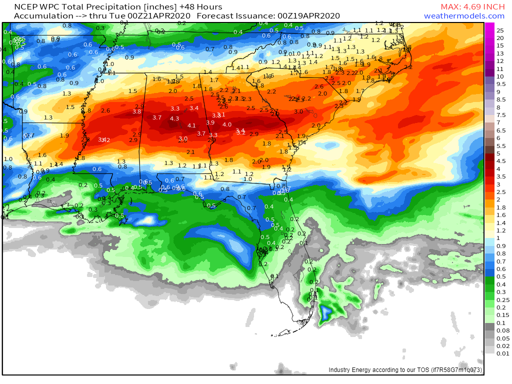
In addition to the severe weather, this event will pose a significant flooding threat as rounds of storms drop heavy rain over the same places repeatedly. The Southeast has been experiencing above-average precipitation for the past several months so soils are already primed for flooding. If you live in an area prone to flooding, make sure you’re prepared for high water.
The severe weather threat will shift towards the GA/SC coast tomorrow morning where damaging winds and embedded tornadoes are expected.
-Jack
