Powerful Storm Developing Off The East Coast Will Remain Far Enough East To Spare Major Impacts
Hello everyone!
A powerful ocean storm is developing off the North Carolina coastline this morning. With strong “blocking” over SE Canada, this would usually mean that a powerful and impactful nor’easter was imminent. However, this system will slide just far enough east to spare the East Coast major impacts. That said, some heavy rain, gusty winds, and coastal flooding is still expected especially on Cape Cod and the islands off Massachusetts. This post will take a quick look at this system’s expected impacts and some of the meteorological processes working to produce such a powerful storm.
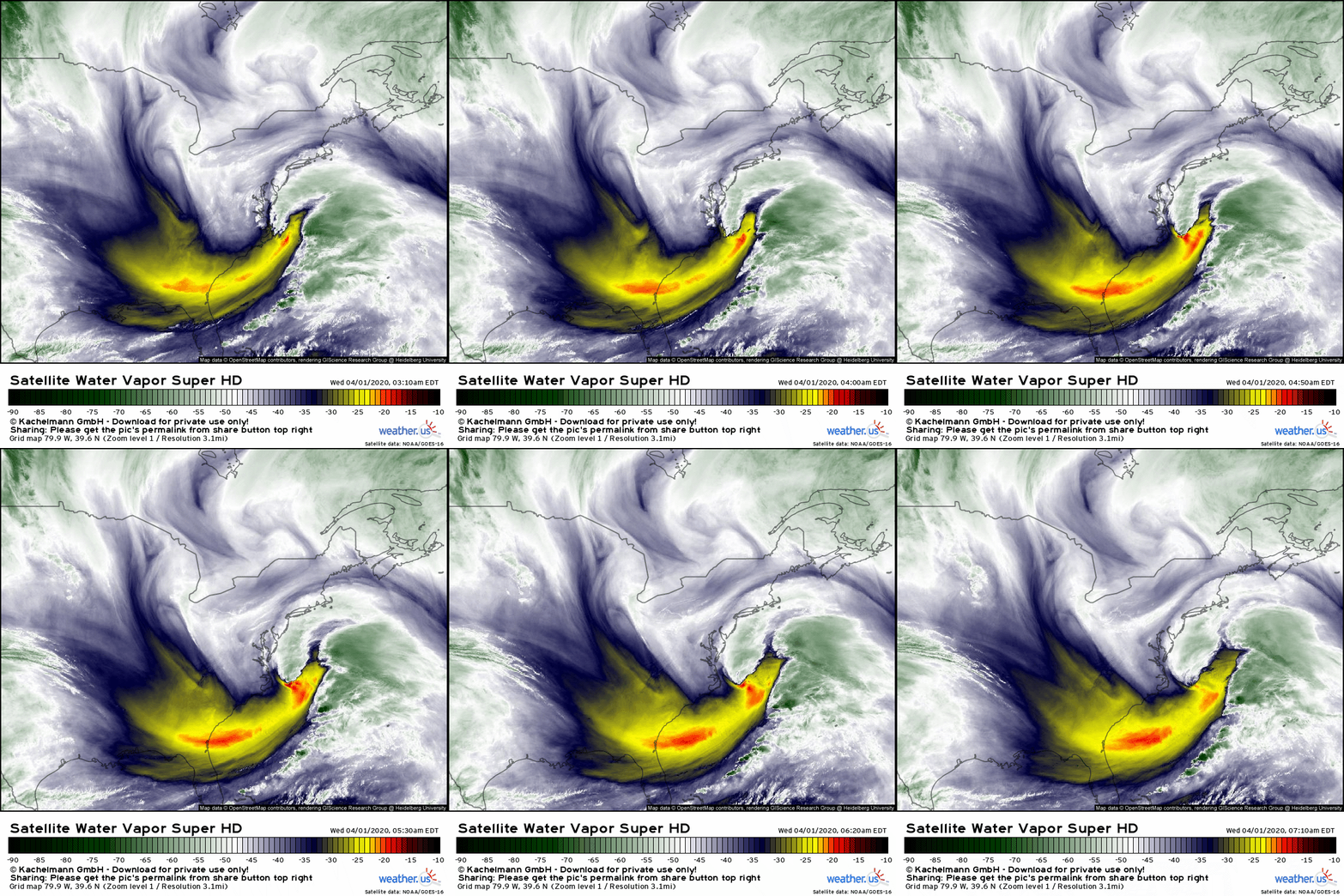
GOES-East WV satellite imagery shows a classic developing mid-latitude cyclone just east of the Outer Banks. Note the system’s well-defined dry slot just west of its plume of moisture (complete with thunderstorm activity) and just south/east of the area of strong uplift just NW of the storm’s center. Also note the southeasterly flow ahead of the storm over Canada and Maine. This is the “blocking” that will eventually stop the storm’s eastward movement and force it back to the northwest.
ECMWF 500mb vorticity forecasts for this evening highlight the mid/upper level pattern that WV imagery hinted at. Note the large blocking high just NE of Newfoundland. That feature will prevent the storm from taking the typical exit ramp into the Canadian Maritimes. Instead, it will remain embedded within a large upper level gyre centered over New York. Both features will guide the storm to the north and eventually northwest later tonight and tomorrow.
The storm will eventually complete a full cyclonic loop southeast of Cape Cod. The storm’s center will remain hundreds of miles offshore even at its point of closest approach which will spare coastal regions from the storm’s strongest winds and heaviest rain. That said, this will be a large storm so you’ll notice its presence even if its center is relatively far from your location.
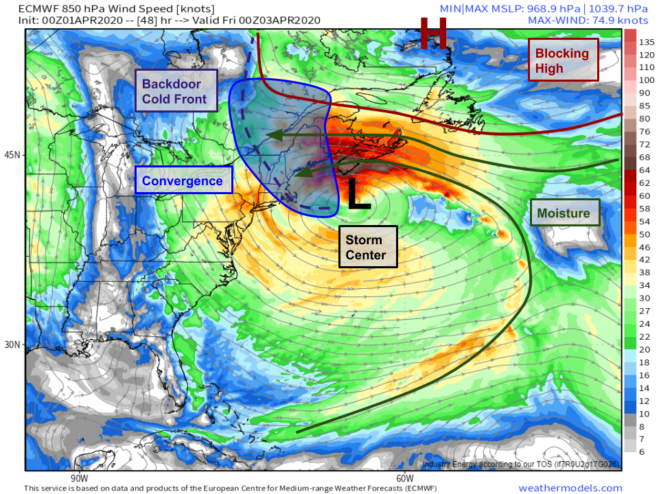
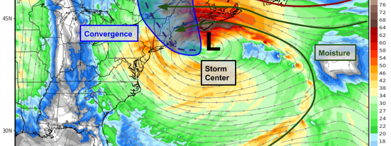
ECMWF forecasts for winds at ~5000ft tomorrow evening highlight the system’s huge wind field (from the Bahamas to Newfoundland and from the Central Atlantic to the Great Lakes) and expansive moisture taps both from the tropical/subtropical Atlantic and from higher latitude parts of the ocean. All this moisture will be funneled west by strong easterly winds between the storm and the blocking high. When that air moves NW of the low’s center, it slows down and a pileup of sorts ensues. That pileup (convergence) forces upward motion. Combine the upward motion with moisture and you get precipitation.
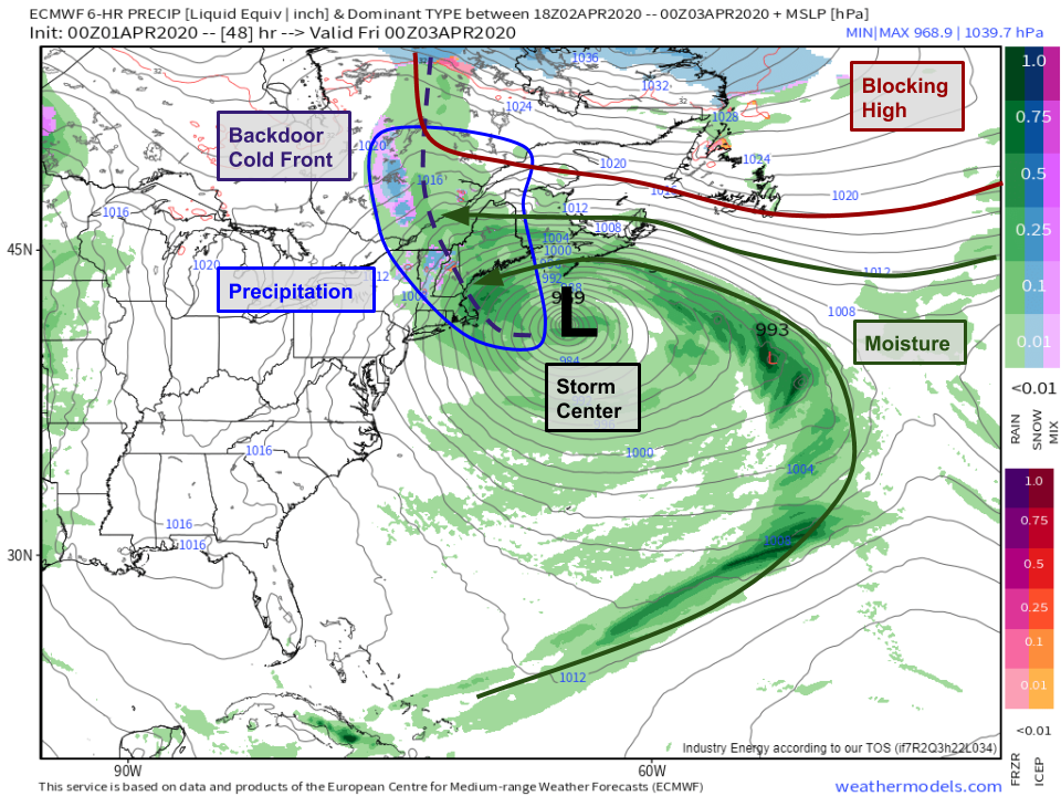
Plotting the same features from 5,000ft on the surface pressure/precipitation forecast for the same time tomorrow evening confirms our inference that a band of precipitation will form along the axis of the backdoor cold front moving from NE to SW around the back side of the storm south of Nova Scotia. Because the air behind this cold front is streaming in from the Atlantic, it will be chilly but not quite chilly enough for snow. Most of New England will enjoy a wind-blown rain with temps in the upper 30s or low 40s. The exception will be in the higher terrain of the White and Green mountains where several inches of snow will fall.
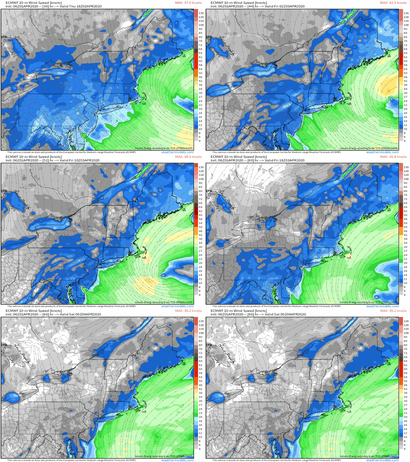
As far as surface winds go, this storm won’t produce any prolific gusts. It’s too big and too far offshore. That said, breezy N/NE winds will persist for quite a while especially in coastal areas as the storm does its loop offshore. The strongest winds will be found on Cape Cod where sustained breezes of 35-40 mph and gusts up to 50 mph are possible. While scattered outages are possible, this will mostly be a nuisance system.
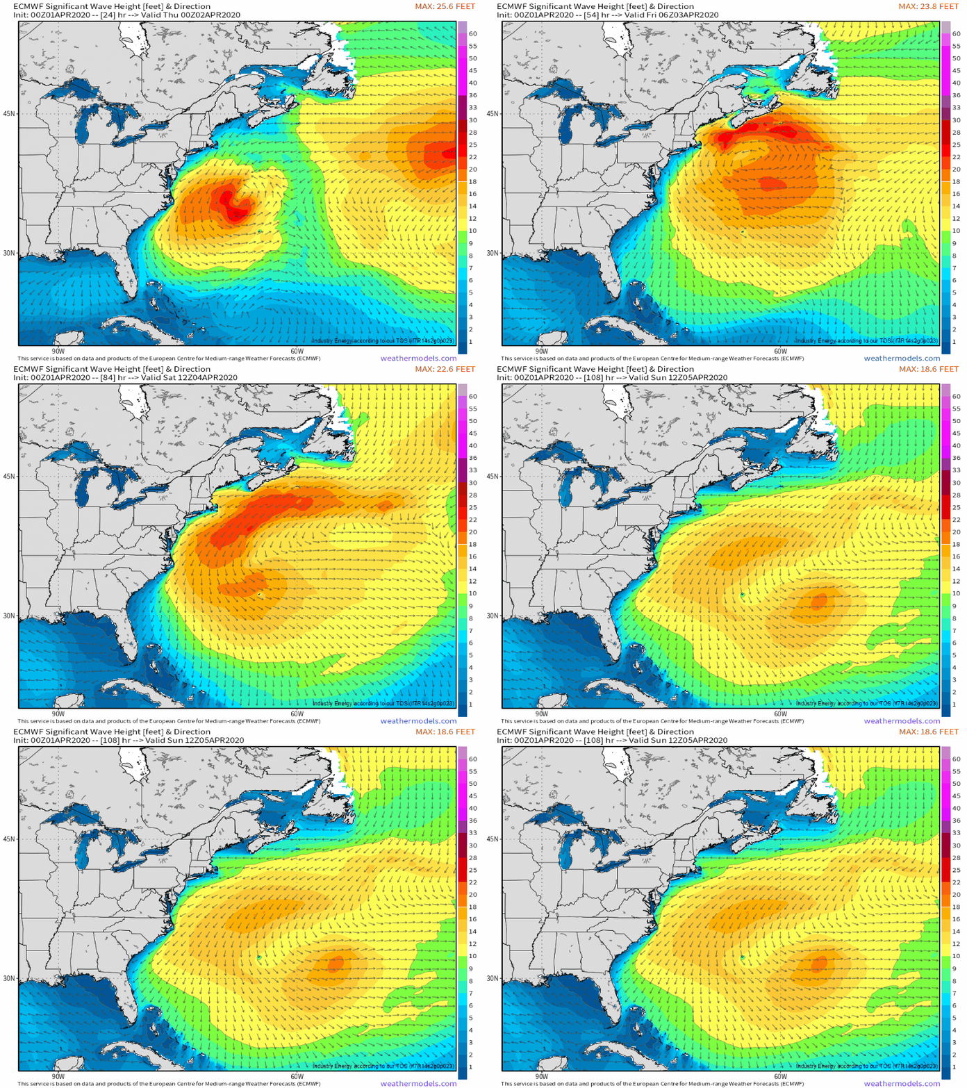
While precipitation and winds will be annoying but not destructive, the waves and storm surge kicked up by days of east/northeast flow could cause some problems for the typically vulnerable parts of Cape Cod. ECMWF significant wave forecasts show rough seas >10ft persisting for several days after the storm departs to the southeast. With the potential for flooding at several high tide cycles, coastal residents should prepare for high water in the usual spots. That said, no major coastal flooding issues are expected.
Wind, rain, and coastal flooding will lessen on Friday and Saturday as the storm completes its loop and departs towards Bermuda.
-Jack
