Significant Severe Weather Appears Likely Across Parts of Northern Illinois Tomorrow
Hello everyone!
Yesterday, I took a look at the emergence of a pattern over the Plains that was likely to be favorable for severe thunderstorms during the second half of this week. Sure enough, storms developed as expected across parts of Kansas and Missouri late last night and dropped some marginally severe hail before dissipating as they moved east. More storms are expected today from Texas all the way up to Ohio. Overall, the forecast for today’s storms still looks pretty good. As discussed in yesterday’s blog, the focal point for severe weather will shift into the Mississippi Valley. Over the past 24 hours, it’s become clear that the storms expected to develop tomorrow are likely to end up being much stronger than I would’ve thought yesterday. This post will focus on the forecast for those storms expected to develop tomorrow.
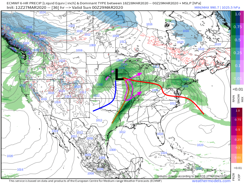
As a quick refresher, here’s the general pattern tomorrow evening as forecast by the ECMWF model. A mature mid-latitude cyclone will be located over Iowa with a cold front extending S/SW of the cyclone into the Southern Plains and a pre-frontal trough extending S/SSE of the cyclone through Missouri into Arkansas/NE Texas. The system’s warm front will be draped over far northern Illinois/Indiana/Ohio. Storms will develop along the pre-frontal trough in Missouri tomorrow afternoon and will rapidly move NE into an environment characterized by warm temperatures and ample moisture.
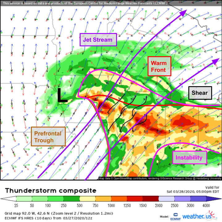
We can take a much closer look at that environment with the ECMWF’s Thunderstorm Composite forecast (click here for a tutorial video discussing the Thunderstorm Composite). The pre-frontal trough of interest marks the western boundary of the region where ample instability is present. This region is located under very strong southwesterly flow aloft. As a result, there will be extremely strong shear available for storms to tap once they develop.
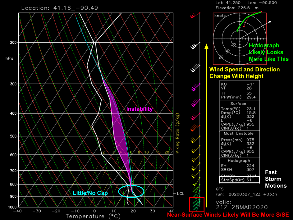
A sounding plotted using GFS data forecast for Central Illinois lets us take an even closer look at tomorrow’s environment. Starting with the primary thermodynamic information, we can see that there’s little/no cap in place to prevent storms from developing. There’s also plenty of instability through a deep layer of the atmosphere. Looking at the wind information, we can see that wind speeds increase rapidly with height from a mere 20kts at the surface to 155kts near the top of the troposphere. While the GFS isn’t explicitly forecasting much in the way of changing wind directions, the model likely isn’t picking up on some smaller-scale features that are likely to push surface winds a bit more towards the south/southeast. As a result, the model is likely underforecasting shear by a bit. Because winds in the mid/upper atmosphere are so intense, storms will be moving extremely quickly. Our best guess is that storms will move around 60kts which comes out to around 70 mph. That means that if a warning is issued for your area, you may not have that much time before the storm is overhead!
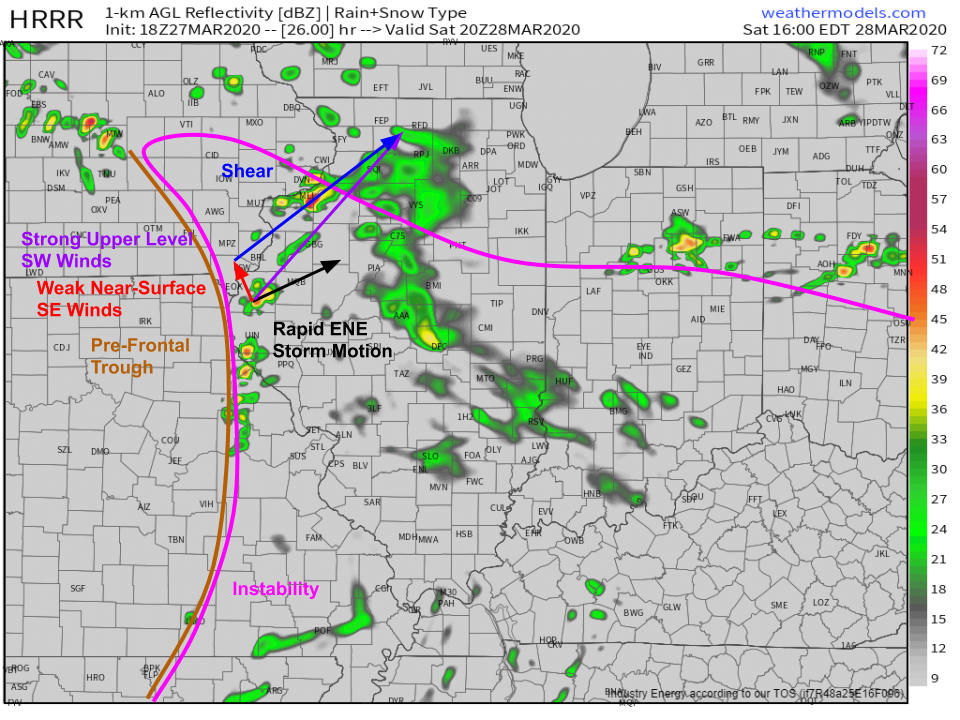
Here’s a look at the HRRR’s forecast for simulated radar imagery tomorrow afternoon. The model is expecting several discrete or semi-discrete cells to form along or just ahead of the boundary by 3 PM CDT. Overlaying some of the wind information we gained from the sounding and the Thunderstorm Composite map, we can see that a storm that pops up along the boundary will rapidly move ENE into the open warm sector, a region of warm temperatures and ample moisture that’s quite conducive to maintaining severe thunderstorms. In that area (ahead of the pre-frontal trough and behind the warm front), surface winds will be relatively weak and out of the S/SE while upper level winds will be screaming out of the SW. The resulting shear will support rapidly rotating supercells, should storms be able to remain discrete.
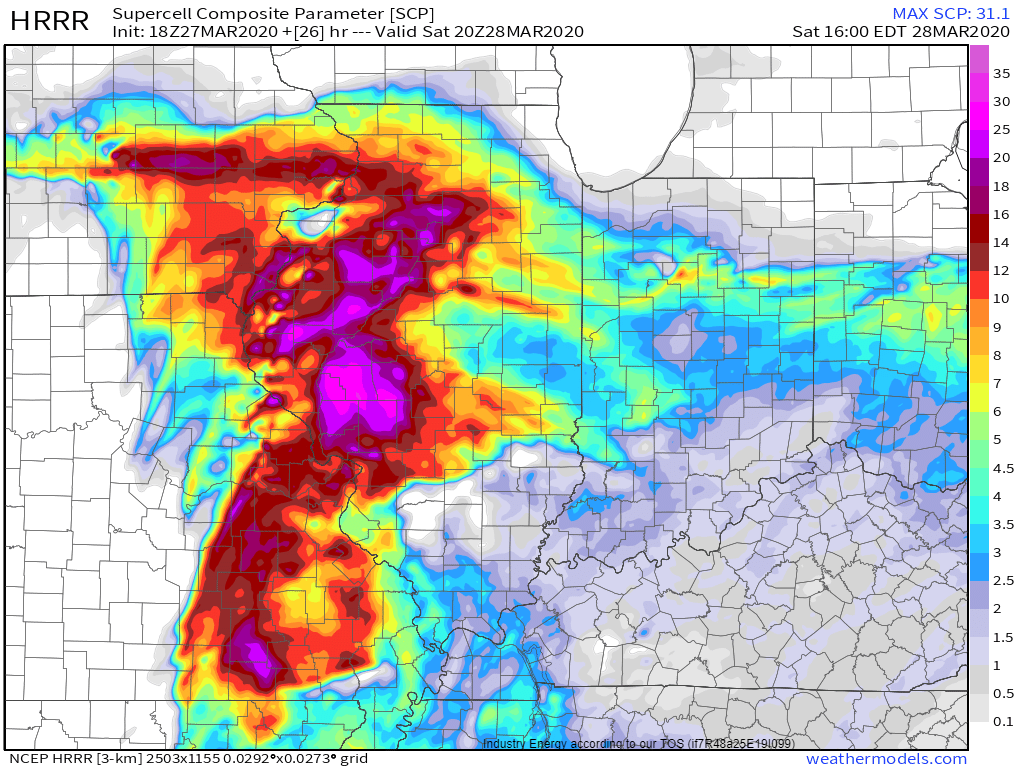
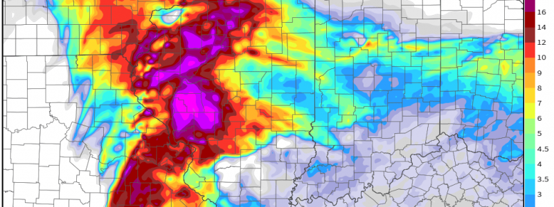
Because of the deep instability, ample moisture, and raucous shear, it’s no surprise that model forecasts for a parameter intended to be a proxy for supercell favorability are nearly maxed out over western Illinois tomorrow afternoon.
While the environment in this region is more than supportive for supercells, none will form if storms quickly aggregate into a linear structure. This is what I expected to happen yesterday. However, upon closer examination and with the benefit of some updated information, that now appears unlikely at least for a few hours late tomorrow afternoon. Why the change? My rationale for expecting a line of storms was that the boundary on which storms were initiating would be a fast-moving cold front which means that after a storm popped up along the boundary, it would remain near the boundary as both features cruised northeast. During this time, more storms would pop up and they’d quickly merge into a line.
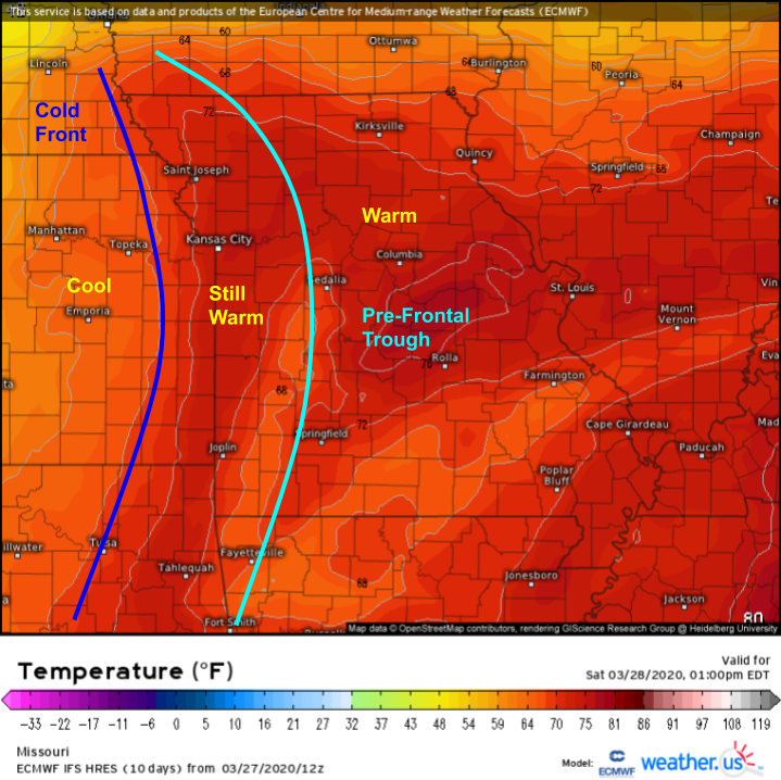 It’s now clear that the boundary of interest isn’t technically a cold front. The system does have a cold front, but it’s lagging about 50-75 miles behind this pre-frontal trough. After looking a bit closer, it’s clear that the deep moisture needed to support severe thunderstorm development is only present ahead of this pre-frontal trough which means that storms won’t be forming along the cold front, but instead along this trough.
Why is that distinction so important? Cold fronts are good at pushing tons of air upward very quickly. This leads to widespread thunderstorm development and the rapid coalescence of individual cells into linear structures. However, the pre-frontal trough isn’t nearly as good at pushing air upwards. This means that fewer storms will develop along the boundary, and thus each storm will have a bit more breathing room. This, along with the rapid storm motions (so cells can outrun the boundary where other storms might be forming) and the extreme shear will favor discrete storm modes for at least a brief window tomorrow afternoon. Eventually, the fact that mid-level winds are nearly parallel to the boundary will lead to storm interactions and mergers.
While storms are discrete, they will be capable of producing strong long-track tornadoes as well as damaging straight-line winds and large hail. Once storms begin merging, the threat will shift a bit more towards damaging straight-line winds though tornadoes and large hail can’t be ruled out even as storms race into Michigan and Indiana later in the evening.
Here’s a short animation showing the HRRR’s forecast for simulated radar imagery through the duration of the event tomorrow. While the model won’t be able to predict exactly where storm cells will track ahead of time, it does do a pretty good job showing the overall evolution of the event from initiation as discrete cells to eventual cell clumps associated with merging supercells.
Severe storms are also expected farther south in Kentucky/Tennessee/Mississippi but because shear won’t be quite as strong in that area, the overall risk for destructive storms is somewhat lower.
-Jack
