Severe Storms and Flash Flooding Expected In Parts of the Southeast Today
Hello everyone!
Today’s main weather story will be strong/severe thunderstorms expected to develop across parts of the Southeast. These storms will produce all available hazards including tornadoes, damaging winds, hail, lightning, and flooding rain. This post will outline where/when to expect storms and some of the meteorological dynamics supporting the severe weather.
As per usual, GOES-East WV imagery is the place to start this morning. A disturbance aloft is clearly evident over Kansas and surface observations suggest that its attendant surface low is located over Oklahoma. A large swath of mid-level dry air is present to the south side of this disturbance as well as strong winds aloft associated with an upper-level jet streak. As low-level moisture is pushed north from the Gulf of Mexico under this mid-level dry air and upper-level jet streak, the stage will be set for severe thunderstorm development.
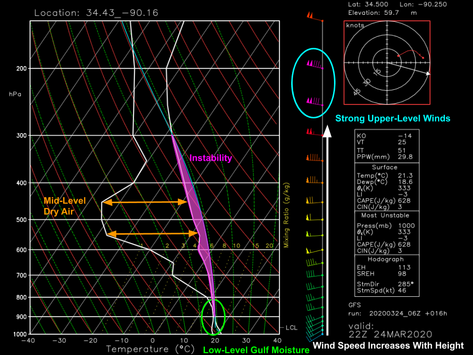
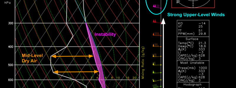
This forecast sounding from the GFS model is valid for a point in northern Mississippi at 4 PM CDT. The strong upper-level winds and mid-level dry air we saw on the WV imagery clearly show up in forecast model soundings and will contribute to enhancing the severe weather threat. The sounding also shows low-level moisture from the Gulf of Mexico which will help parcels forced to rise from near the ground maintain a temperature warmer than the environment due to the release of latent heat as water vapor is condensed into liquid droplets and eventually ice crystals. The area on the Skew-T/Log-P diagram between the parcel trajectory (light blue) and the environmental temperature (right-hand white line) represents the parcel’s instability (CAPE). While this instability profile isn’t prolific by any means, it will be sufficient to support severe thunderstorms given the strong unidirectional shear (winds increase in speed from ~15kts at the surface to ~135kts at around 40,000 feet).
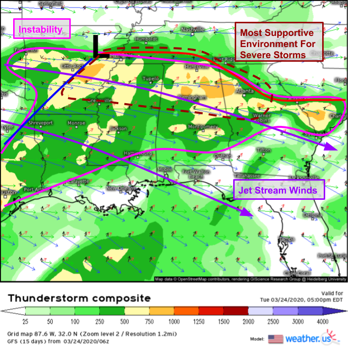
Here’s a look at the Thunderstorm Composite forecast product (tutorial here) for the same time as the sounding discussed above. The corridor of instability >500 J/kg is clearly visible from eastern AR through northern MS/AL into NW GA. We’ve already covered the jet stream cruising through this area at around 30-40,000 feet. Now we can focus on how the winds are changing speed/direction with height (the shear). Note that just south of the warm front (near Tupelo for example, where the sounding was taken), the wind speed changes drastically with height (the sounding showed this clearly) but the wind direction only changes a little bit (from SW at the surface to W in the mid levels to WSW in the upper levels). Also note that these winds are roughly parallel to the warm front (marked in bright red) which will be responsible for storm initiation today. As a result, I’d expect storms near the warm front to be of a messy linear/multicell mode with damaging winds and large hail being the primary threats.
Farther south between Greenville MS and Birmingham AL, notice that the change in wind direction becomes a bit larger (~90 degrees instead of ~45 degrees). This is right at the southern edge of the stronger instability and will be the region most conducive to supercell development if storms can initiate in the open warm sector (away from any fronts). Any supercells that develop here will be capable of producing damaging winds, large hail, and tornadoes.
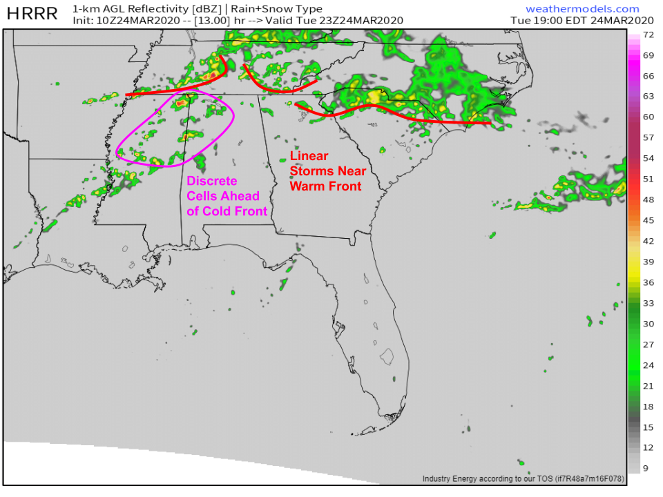
Here’s a snapshot of the HRRR’s forecast for simulated radar this evening at 6 PM CDT. While the model can’t nail the development of specific cells on a town-by-town basis (though it gives the illusion of this precision), it does a good job confirming the overall distribution of storms inferred in our analysis above. Along the warm front in TN/NE GA/N SC/S NC, storms will clump together in linear structures producing damaging winds and some hail. Farther south in MS/AL, storms will be more discrete and capable of becoming supercellular. Should any supercells develop, tornadoes would be possible in addition to strong winds and hail.
In addition to the wind/hail/tornado threats posed by these storms, we’ll also have to think about flash flooding as storms repeatedly “train” over the same areas.
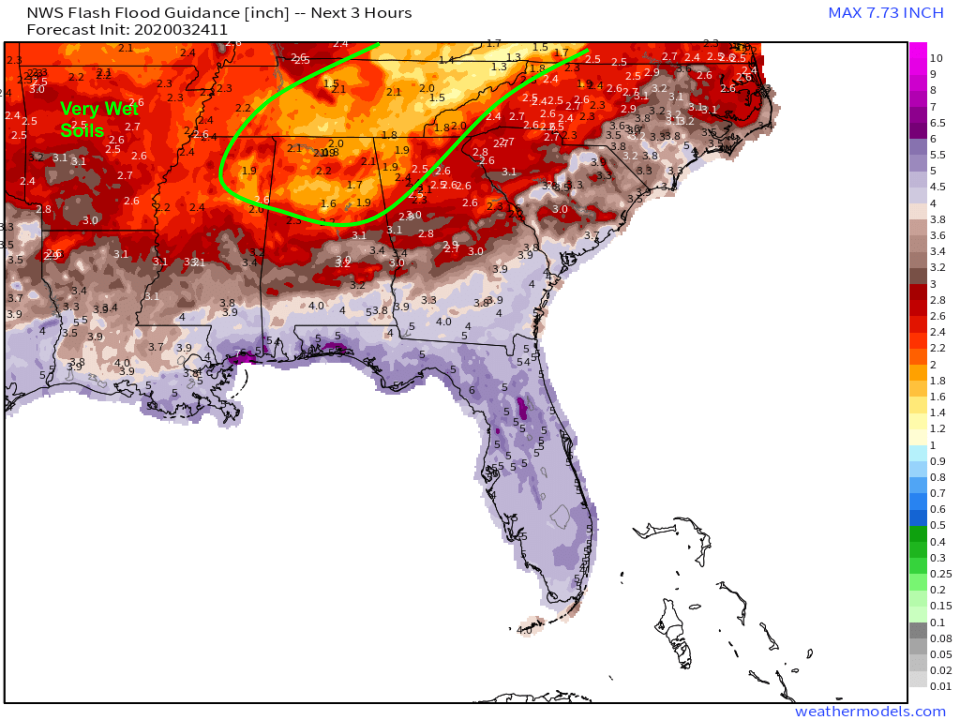
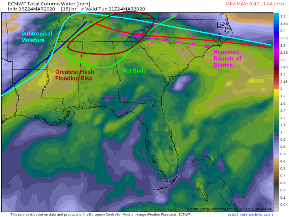
Flash flood guidance suggests that much of northern AL and adjacent parts of NW GA/eastern TN only need 1.5-2″ of rain over the course of 3 hours to produce flash flooding. That’s because there’s been so much rain in this region over the past few months that soils are already near saturation. Any additional rain that falls can’t be absorbed into the ground, and it has no choice but to run off into rivers/streams.
Plotting that area of wet soils over the ECMWF’s forecast for moisture this afternoon and the approximate location of the warm front clearly points to an area conducive for flash flooding this evening (highlighted in dark red on the map above). This area is already near saturation and it will be subject to repeated rounds of heavy rain as storms move along the warm front. In fact, heavy rain is already falling in this area as the first round of storms moves through and flash flood warnings are already in effect for parts of northern AL.
Flash flooding and severe weather will subside later tonight as instability wanes and the system moves east.
-Jack

