Severe Storms Expected In The Southern Plains This Week As Spring Begins
Hello everyone!
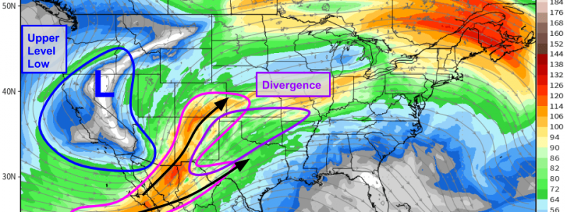
In a welcome (for some anyway) sign of the changing seasons, severe thunderstorms will develop in the southern Plains each afternoon this week ahead of an upper level low currently drifting through California. This post will take a quick look at the overall pattern through the end of the week including which areas are most at-risk for severe storms and what the main threats might be.
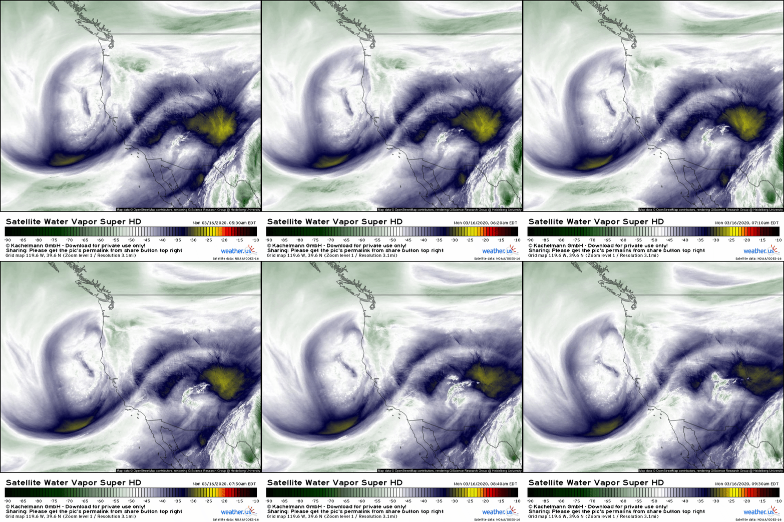
This upper level low swirling west/northwest of San Francisco will be responsible for creating an overall large-scale environment favorable for severe weather in the Plains this week. On the loop above, you can see a plume of Pacific moisture advancing into the southern Rockies and another plume of moisture closer to the Gulf of Mexico in Texas/NE Mexico. If you watch carefully, you’ll notice that winds over California are out of the south while winds over the Southern Rockies are out of the southwest. This divergence aloft helps to support upward motion which is needed to support thunderstorm development.
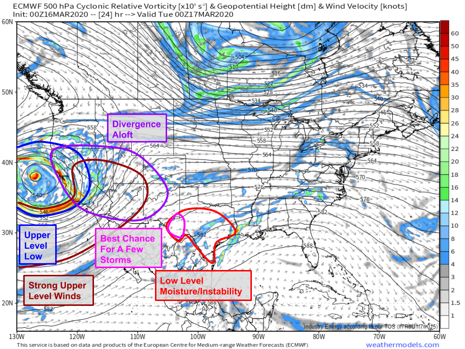
Not many storms are expected today as the upper level low and its upward motion/strong upper level winds (important for wind shear) remain too far west over the Pacific Ocean. Low level moisture, and the instability it supports, will remain confined to Texas. The best chance for a few storms will be on the far western edge of this low level moisture pool. Storms that are able to form here could produce some strong winds and large hail. At the moment it looks like there won’t be quite enough shear or low level moisture for tornadoes, though it’s unwise to totally rule one out.
Tomorrow, the upper level low will shift slightly southeast. However, a disturbance will zip around the base of the low and head northeast into the Plains around sunset. That disturbance will bring with it a little taste of the upward motion/upper level divergence/stronger upper level winds associated with the upper level low. Additionally, as surface high pressure settles into the western Atlantic, moisture from the Gulf of Mexico will continue to advance into the Plains. As a result, conditions will be favorable for severe thunderstorm development across a wider swath of western Texas and adjacent parts of far western Oklahoma.
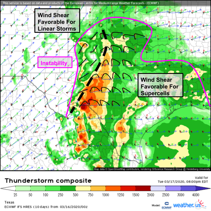
The ECMWF’s thunderstorm composite map gives us a more precise look at the ingredients necessary for severe thunderstorm formation. Instability on Tuesday will be more widespread than today, but it also likely won’t be quite as potent. CAPE values between 500 and 1000 J/kg are right on the lower edge of being supportive for severe thunderstorm development, especially without a strong frontal boundary to force rising motion. Upward motion tomorrow will be provided by a dryline. It’s tough to get strong upward motion along a dryline, so expect storms to be relatively isolated at least initially. I’ve put a thick dashed line on the map which roughly separates the area where shear is set up favorably for linear storm modes from the area where shear is more favorable for supercells. It’s not quite clear just how many supercells will be able to form given the lack of deep instability and upward motion, but those that do manage to pop up will be capable of producing damaging winds and large hail. A tornado or two is also possible especially east of that dashed line on the map above.
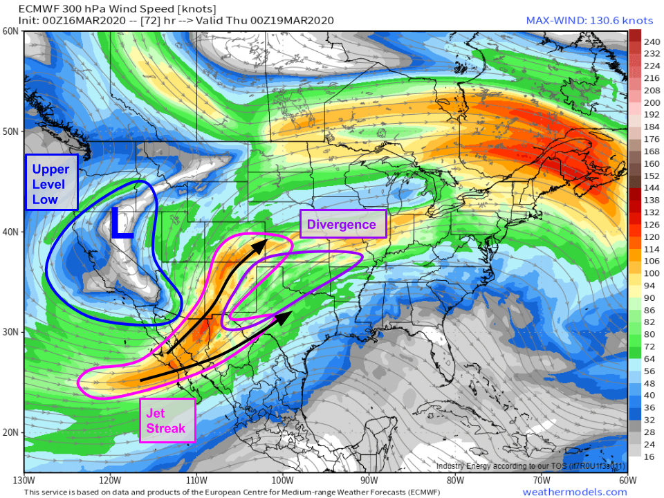
Coverage and intensity of storms looks to substantially increase on Wednesday as the upper level low begins moving into the Rockies. This will place the Plains squarely in the most optimal spot for upper level divergence which means that the dryline will get a much-needed boost as it tries to drag moist air near the surface high enough for it to rise freely to the tropopause.
The ECMWF’s thunderstorm composite forecast shows much greater instability and much higher shear on Wednesday in response to the upper level low moving east. As a result, while similar areas will be impacted by storms (mostly western Texas, parts of SW OK too), severe weather will be more intense and more widespread. At the moment, both supercells and some linear structures are possible though there’s still too much uncertainty to try to pin down where each type of storm (and associated hazards) are most likely. Damaging winds, tornadoes, and large hail are all possible with these storms.
The upper level low will fall apart as it moves east on Thursday, but it will still be supportive of some thunderstorms in parts of Oklahoma, Kansas, and Missouri. It still remains to be seen just how unstable the air in this region will be after Wednesday’s storms, and thus the magnitude of the severe threat remains unknown. Little to no storms are expected on Friday as the upper level low fades into a weak disturbance which will be racing into eastern Canada.
-Jack
