Severe Storms Possible in Parts of the Mid Atlantic Today
Hello everyone!
Unseasonably warm temperatures across much of the Eastern Seaboard combined with an approaching cold front and strong upper level trough will provide a favorable environment for severe thunderstorms across parts of the Mid Atlantic today. A major severe weather outbreak is not expected, but as we saw earlier this month, these low-topped squall lines can produce some substantial damage if everything lines up right. This post will take a closer look at the forecast for this afternoon’s storms.
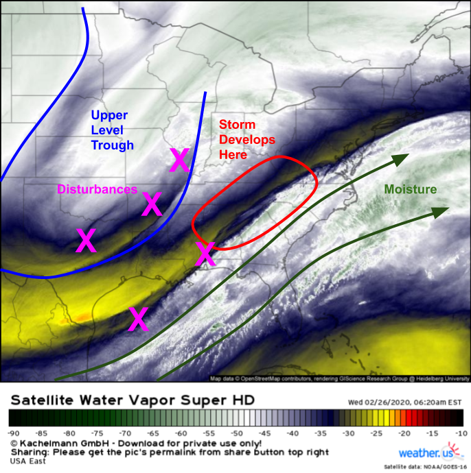
GOES-East WV imagery does a good job highlighting today’s setup on a large scale. An upper level trough is clearly evident over the Central US with several strong disturbances along the trough’s southeastern flank. A deep plume of subtropical moisture is noted southeast of these disturbances. As the trough moves east and its associated disturbances begin to merge later today, we’ll see the rapid development of our storm begin over the southern Appalachians. As the storm develops, it will lift that plume of moisture northward, setting the stage for severe storms this afternoon/evening.
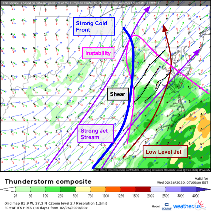
A look at the ECMWF’s Thunderstorm Composite forecast for this evening shows a classic high shear/low CAPE environment across the Mid Atlantic. Strong dynamics associated with the intensifying storm will strengthen winds through the low/mid levels while the jet stream roars near the top of the atmosphere. While moisture advection and falling mid level temperatures will enable some instability to develop by this afternoon, widespread cloudcover in the area of interest will preclude much daytime heating, thus limiting just how unstable the atmosphere can become.
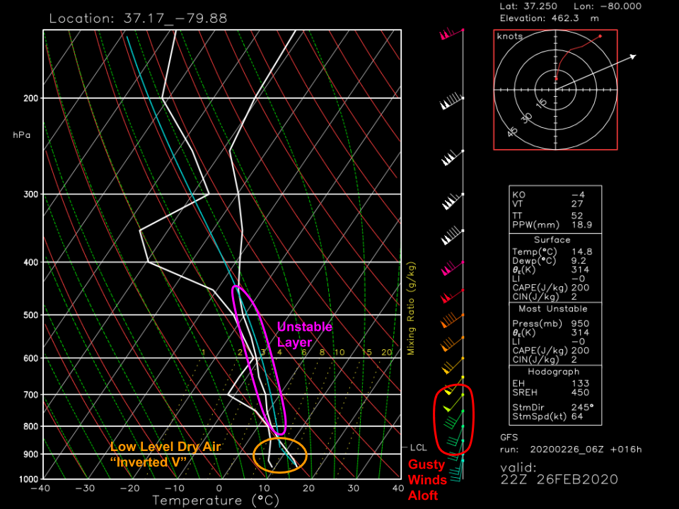
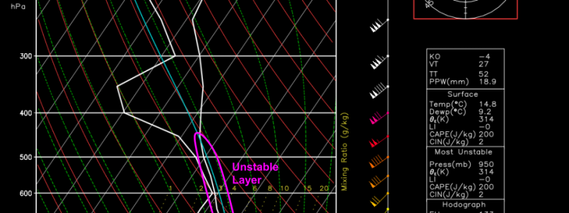
This can be visualized another way by looking at forecast soundings for points ahead of the line (this one selected in western VA near Roanoke). Note that there is a layer of unstable air from ~850mb to ~450mb, but the rising parcel is never that much warmer than its surroundings (blue line is close to white line). This will put a cap on just how intense today’s storms can become. That said, a classic “inverted-V” signature is noted in the lowest levels as the temperature and dew point separate. This means that there’s room for evaporation in the low levels as rain falls out of the thunderstorm clouds. This evaporation cools the air via latent heat processes, making rain-cooled air negatively buoyant and accelerate towards the ground. This acceleration towards the ground, combined with gusty winds aloft that can get mixed down to the surface will fuel the damaging wind threat this afternoon. While a brief tornado is possible due to mesovorticies embedded within the line, damaging winds will be the main threat today.
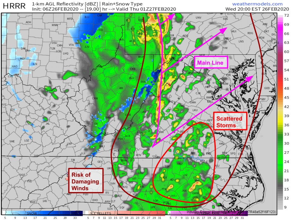
Simulated radar imagery from the HRRR does a pretty good job guesstimating what the situation will look like this evening. Expect the main squall line to be focused from southern PA through northern/central VA while more scattered storms develop farther south in southern VA/northern NC. Any storm today could produce damaging winds given the dynamics discussed above, but the squall line will be able to produce the strongest and most-widespread winds. Storms will slowly weaken as they move east during the overnight hours.
-Jack
