Snow Likely In North Carolina on Thursday
Hello everyone!
As the week of wet weather in the Southeast continues, it appears as though one of the disturbances that will bring a round of heavy rain to parts of MS/AL/GA/SC will also bring a (brief) round of moderate to heavy snow to North Carolina. This disturbance will be fast-moving so significant accumulations aren’t expected, but even an inch or two can cause problems in parts of the country that don’t often experience accumulating snow.
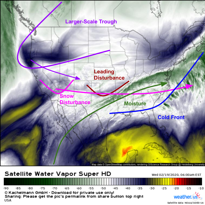
GOES-East WV imagery, as per usual, does a great job highlighting how the ingredients necessary for snow will line up over NC on Friday. A cold front has crossed the region and is now stalling out over the Gulf Coast. Northerly winds behind that front will bring cold air south from Canada, opening up the possibility for frozen precipitation. Moisture necessary for precipitation is streaming northeast from the subtropical Eastern Pacific while disturbances capable of producing upward motion are moving quickly east ahead of a larger trough digging into the Rockies.
The leading disturbance produced a round of precipitation that’s now exiting the Carolinas as I write this around 7 AM Wednesday. Subfreezing air didn’t have enough time to make it into this round of precip, so it fell as rain. By the time the second disturbance, currently located over the Desert Southwest, arrives tomorrow, that colder air should at least be “close enough” for some snow, even though it won’t be deeply entrenched.
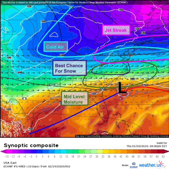
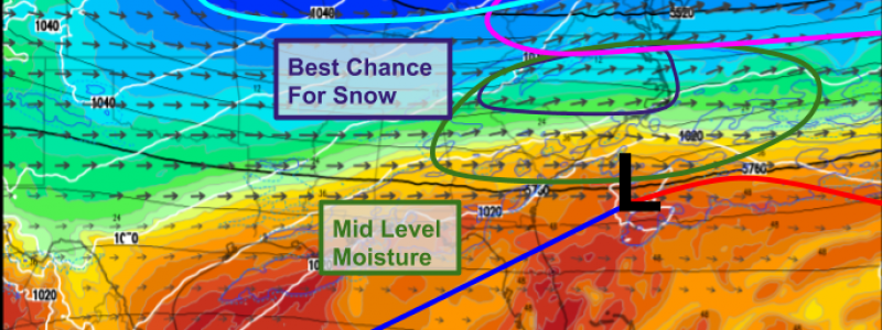
Here’s a look at the forecast for each of those ingredients valid tomorrow at 4 PM. True cold air will remain locked north of the Ohio River and Mason-Dixon line, but “cold enough” air will seep into North Carolina by the time forcing for ascent associated with the upper-level disturbance mentioned above arrives. This disturbance will be assisted by upward motion associated with a jet streak located over the northern Mid Atlantic, and will be able to tap into some of that Pacific moisture seen on visible satellite imagery this morning. The net result will be atmospheric conditions favorable for a period of snow tomorrow afternoon/evening.
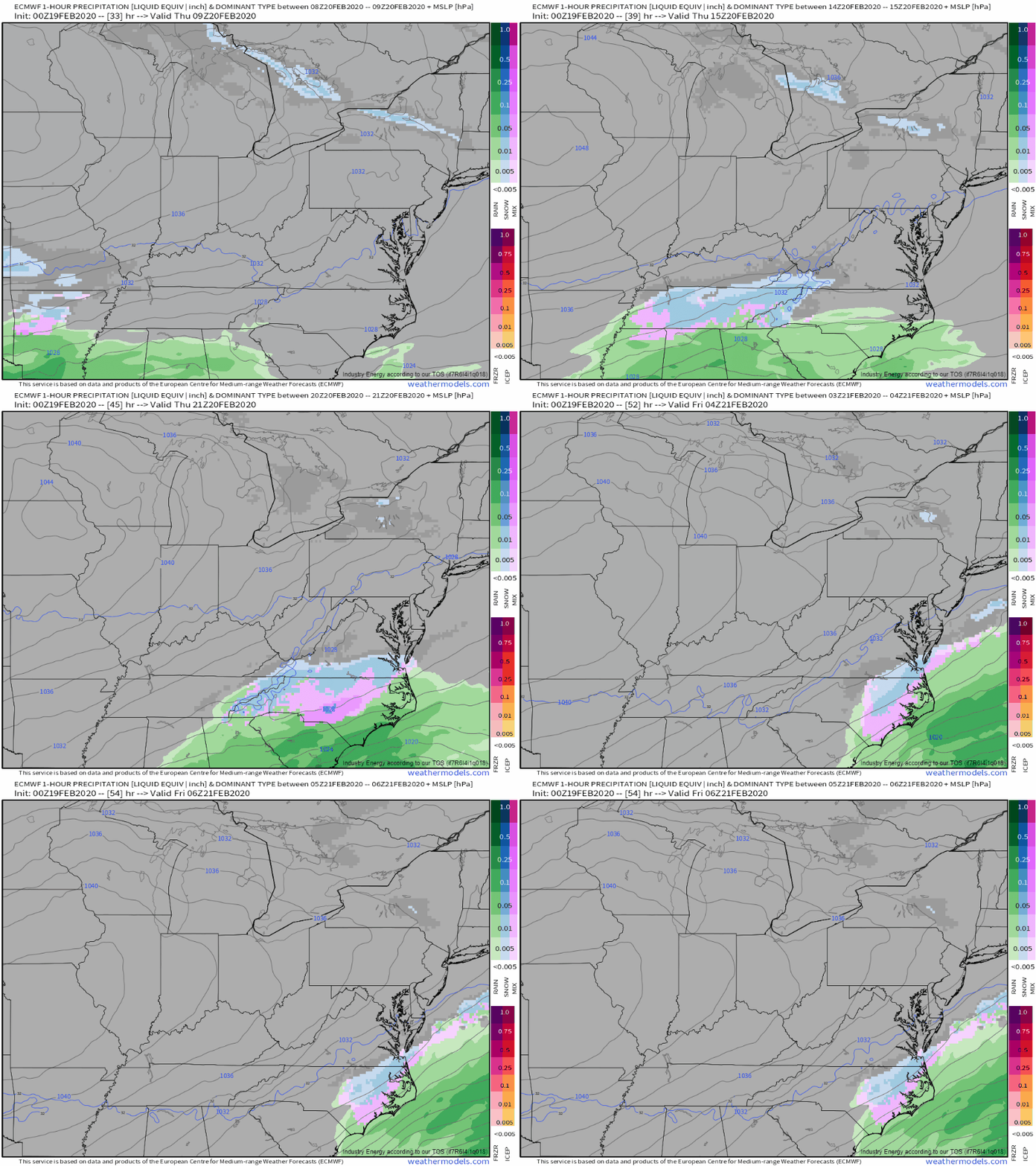
Here’s how the ECMWF model expects the system to evolve hour-by-hour tomorrow. Snow will initially break out over southern Missouri before quickly moving east through Kentucky into North Carolina and southern Virginia. Given how zonal (west->east) winds in the upper levels are, this disturbance will be fast-moving and the northern extent of precipitation will be relatively limited.
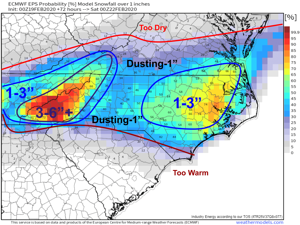
How much snow is expected to fall? I think EPS guidance has a pretty good handle on this system and its forecast for the probability that snow accumulations exceed 1″ is shown above. Of course the mountainous terrain of far western NC and far eastern TN has the best shot of substantial accumulations from this storm. It’ll be much harder to get snow to “stick” in the lower elevations, especially given that temperatures will be around or a little above freezing. The exception to this general expectation will be found over eastern NC where a period of heavier snow might be able to drop a quick 1-2″. Overall, I think this is a relatively low-impact storm but if you’re headed out and about over eastern NC tomorrow evening, be prepared for a few potentially slick spots on the roads.
-Jack
