Several Days Of Active Severe Weather Expected This Week Across The South
Hello everyone!
After a fairly quiet weekend, the next system to watch for regionally significant weather is now developing over the Plains. While heavy snow is falling in parts of the Rockies today, it’ll take about a day for this system to get its act together and start bringing impactful weather to lower-lying areas farther east. With that in mind, the ingredients won’t come together for organized severe thunderstorm activity today. However, tomorrow will mark the beginning of a three-day severe weather event across the Deep South as this system moves steadily east.
GOES-East WV imagery this morning does a good job highlighting the key features we’ll be tracking over the next few days. As per usual, we have two disturbances to watch over the next few days. The southern disturbance, currently located near the Baja California peninsula, will mostly disintegrate as it moves northeast across the Mexican mountains today. That disturbance will be the one to watch for severe thunderstorm development as it moves through eastern TX/LA/AR tomorrow. The northern disturbance will end up being the seed for the primary storm’s development which will occur Thursday over the Southeast.
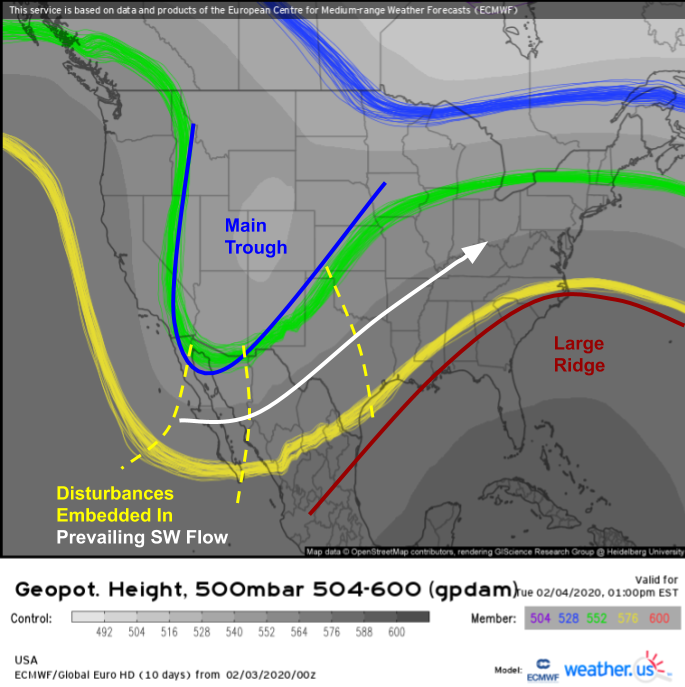
Here’s the ECMWF EPS spaghetti forecast for 500mb heights tomorrow afternoon. Our main disturbance will be drifting slowly through the Rockies, not too far from where it is now. Similarly, the large ridge off the Southeast will remain more or less stuck in place this week. The features to watch for severe thunderstorm formation are the disturbances embedded within broad southwesterly flow from Baja California into the Ohio Valley. The leading disturbance will be responsible for Tuesday’s severe threat, the second disturbance will emerge during the early morning hours on Wednesday, and the third disturbance will be responsible for Wednesday’s severe threat.
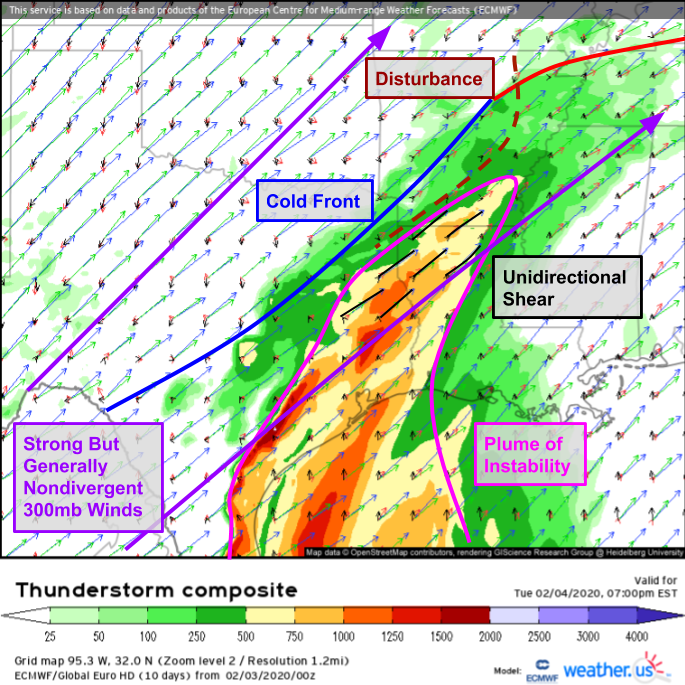
Here’s a look at tomorrow’s severe weather setup as forecast by the ECMWF and visualized by the Thunderstorm Composite product. A plume of weak instability is forecast from eastern TX through southern AR ahead of a fairly weak cold front. While wind shear profiles are favorable for severe thunderstorms, there’s plenty of uncertainty regarding just how much instability will be available.
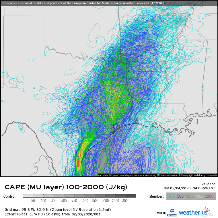
This EPS spaghetti plot showing each member’s forecast for various CAPE thresholds highlights the uncertainty present in the instability forecast across our area of interest. While >1000 J/kg of CAPE seems like a good bet across eastern TX, the range of possible outcomes for southern AR and NW LA is anywhere between 100 J/kg (not supportive of severe storms) and 1000 J/kg (supportive of severe storms). What’s responsible for this uncertainty? It’s not yet clear how much sunshine will develop in this area tomorrow morning after a round of showers moves through during the morning. If those showers move out quickly and sunshine is able to develop during the midday hours, more instability will develop. If the showers linger a bit longer, the air will remain cooler and thus more stable.
I’m also not impressed by the forcing mechanisms available for storm development tomorrow. The cold front won’t have much southeastward momentum by the time it reaches TX/OK, the disturbance currently drifting over the Baja peninsula will be reduced to a nearly-indistinguishable blip in the flow, and the jet-level winds show barely any divergence. If the atmosphere fails to produce a single thunderstorm capable of taking advantage of the environment tomorrow, I wouldn’t be all that surprised.
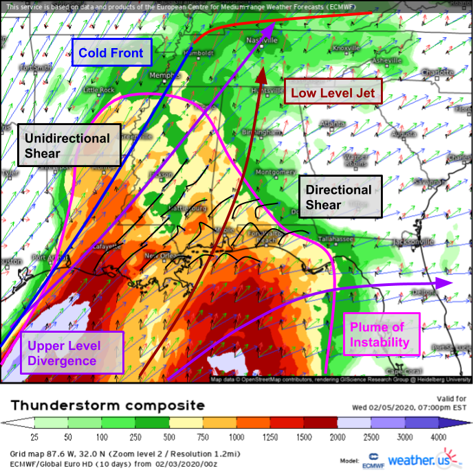
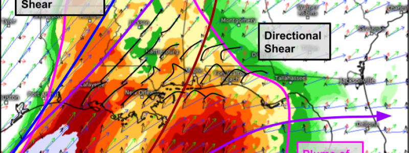
On Wednesday, the atmosphere will be much more favorably set up for severe weather. A strengthening low level jet will help bring warm/moist/unstable air north from the Gulf of Mexico while the ejection of the main trough out of the Rockies will help get the cold front moving and air parcels rising. Shear profiles will vary a bit across the area of interest on Wednesday with unidirectional shear over LA/MS favoring the development of a squall line while shear profiles that include more directional variability exists farther east across SW AL and the FL Panhandle. If storms were able to develop in these areas, a more discrete mode might be possible for a few hours before the cold front eventually sweeps through the area. Damaging winds and embedded tornadoes will be the primary threat with all storms.
By Thursday, additional energy will be added to the system as a series of disturbances drop into the main trough over the Mississippi Valley. The addition of colder air on the NW side of the storm will strengthen the thermal gradient (horizontal change in temperature) which in turn will strengthen the wind field. The net result will be much more kinetic (wind) energy available for thunderstorms to tap into.
Here’s what the setup on Thursday looks like. A strong low level jet will develop in response to a strong upper level jet streak running from Detroit to Nova Scotia. That LLJ will carry unstable air north, setting the stage for storms to develop as our cold front continues marching east. This setup strongly favors the development of a squall line with damaging winds and embedded tornadoes. The availability (or lack thereof) of instability will determine where exactly the northern edge of the severe risk is, but I think a low-topped line of storms capable of damaging winds is possible as far north as VA/MD.
I’ll have another post tomorrow or Wednesday AM that focuses more on the Thursday severe threat once its details become a bit more clear.
-Jack

