An Updated Look at the Prospects for an East Coast Storm This Weekend
Hello everyone!
Over the past several days, we’ve been watching the possibility of a coastal storm off the East Coast at some point this weekend. This post will further refine the thoughts presented in previous blogs, both on Saturday afternoon and Monday morning. As is usually the case with a system like this, the forecast is far from certain at this stage in the game. That said, the forecast is slowly but steadily becoming a little clearer as new information becomes available.
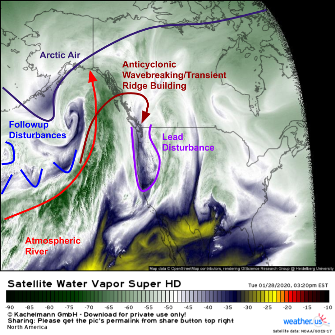
Here’s a look at the pattern across North America and adjacent parts of the Northeast Pacific this evening. The lead disturbance we’ve been following across the Pacific for the past several days has now moved onshore in the Pacific Northwest and is slowly drifting south into California/Nevada. An extremely powerful storm has formed south of Alaska and will barrel into the state this evening. Ahead of that storm, a long plume of tropical moisture is moving northward. This warm air advection will result in the building of a ridge of high pressure over the West Coast tomorrow. However, this ridge will quickly become oriented more NE/SW instead of N/S in response to the continued presence of a strong zonal jet over the Pacific.
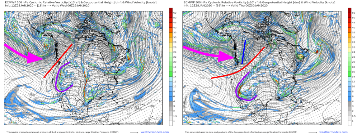
Here’s a look at ECMWF forecasts of 500mb vorticity tonight (left) and tomorrow evening (right). Notice how quickly the ridge over the West Coast gets knocked on its side by the incoming jet and a disturbance on its leading edge. While the Alaskan cyclone has a decent shot at disrupting the persistent zonal (west-east) flow pattern, the Pacific jet won’t be going down without a fight. Any longer-term effects this storm (and whatever happens out in the Atlantic this weekend) has on the pattern as a whole will take a while to materialize.
This quick pushing over of the West Coast ridge is one reason a powerful storm off the East Coast will be hard to come by this weekend, though it certainly doesn’t look impossible at this point.
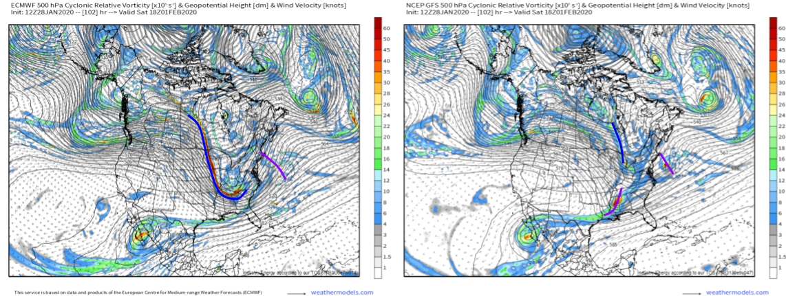
Interestingly, today’s 12z runs of the ECMWF (left) and GFS (right) both failed to produce a storm that brought major impacts to the East Coast, but for vastly different reasons. The ECMWF shows a very strong secondary disturbance dropping way south into Tennessee. If the lead disturbance were in the NC/SC area at this time, it would be game on for a major (if fast-moving) storm. However, the model shows that lead disturbance southeast of Cape Cod. The GFS manages to split the lead disturbance into two segments while keeping the northern/secondary disturbance extremely weak and confined to Ontario. If both scenarios don’t produce a storm, why do we care about their differences? If the ECMWF has a better handle on the situation, we’re a 4-8 hour timing error on the lead shortwave away from a major storm. If the GFS ends up being more accurate, there’s basically no way we can get a major storm even if the timing ends up shuffled around a bit.
At this point, faced with a large and meaningful discrepancy between the leading global models, our best bet is to turn to ensembles.
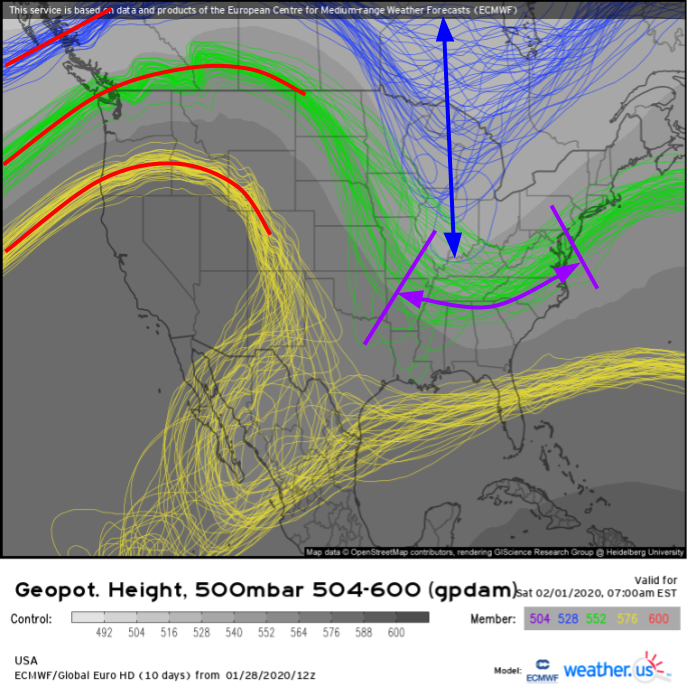
A quick glance at EPS spaghetti guidance for 500mb heights on Saturday morning shows a wide range of possible outcomes regarding the timing and placement of our various disturbances over the East Coast. Generally, the lead disturbance will show up in the green contours (highlighting individual ensemble member forecasts for the 552dam geopotential height contour) while the northern/secondary disturbance will show up in the blue contours (highlighting individual ensemble member forecasts for the 528dam geopotential height contour). The fact that guidance doesn’t have a clear idea whether the northern disturbance will be a strong closed low over MI/WI/IL/IN or a weak open wave over northern ON is fairly remarkable. Uncertainty regarding the position and strength of the southern stream system is nearly as bad with the range of possible outcomes currently spanning from Delaware to Arkansas.
This begs the question: what’s causing all this model confusion?
Let’s start with the northern stream.
We want to know why the ECMWF is forecasting a strong/digging northern stream disturbance while the GFS is forecasting a weak/sliding disturbance. After quite a bit of analysis, I think the key to this part of the forecast lies northeast of Hawaii on Thursday afternoon/evening.
An upper level low will be located northeast of Hawaii on Thursday, as forecast by both models. The key difference is that the ECMWF shows a widespread area of strong thunderstorm activity in this low’s warm sector, while the GFS is expecting relatively modest thunderstorm activity focused right along the system’s cold front. What on earth does this have to do with the storm off the East Coast next weekend?
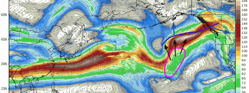
Thunderstorms release a tremendous amount of heat energy into the upper atmosphere. If enough thunderstorm activity is able to persist for a long enough time, that release of heat energy can be sufficient to alter the structure of the jet stream. The ECMWF model’s forecast for upper level (jet stream) winds highlights this beautifully.
The region where thunderstorms would be ongoing is circled in pink. Outflow from those thunderstorms (black) leads to a strengthening and northward expansion of a jet streak south of Alaska (dark blue line). As the western part of this jet streak bulges northward, pushed by the thunderstorm outflow, the eastern part of the jet streak begins digging south into British Columbia. What goes up must come down, even in meteorology!
It just so happens that the disturbance embedded within the eastern part of the aforementioned jet streak is the northern disturbance of interest to those along the East Coast. The more it digs, the better our storm chances become (provided that the southern/lead disturbance cooperates).
So which outcome is more likely? While the ECMWF sometimes is overeager with convection, I have a whole lot more faith in its ability to resolve convective features than I do in the GFS. While satellite imagery on Thursday will hold the true key, my money is on the more amplified solution at the moment based on my knowledge of each model’s shortcomings/biases.
Now that we know a little bit more about what might be responsible for the uncertainty associated with the northern stream system, let’s take a look at the southern stream.
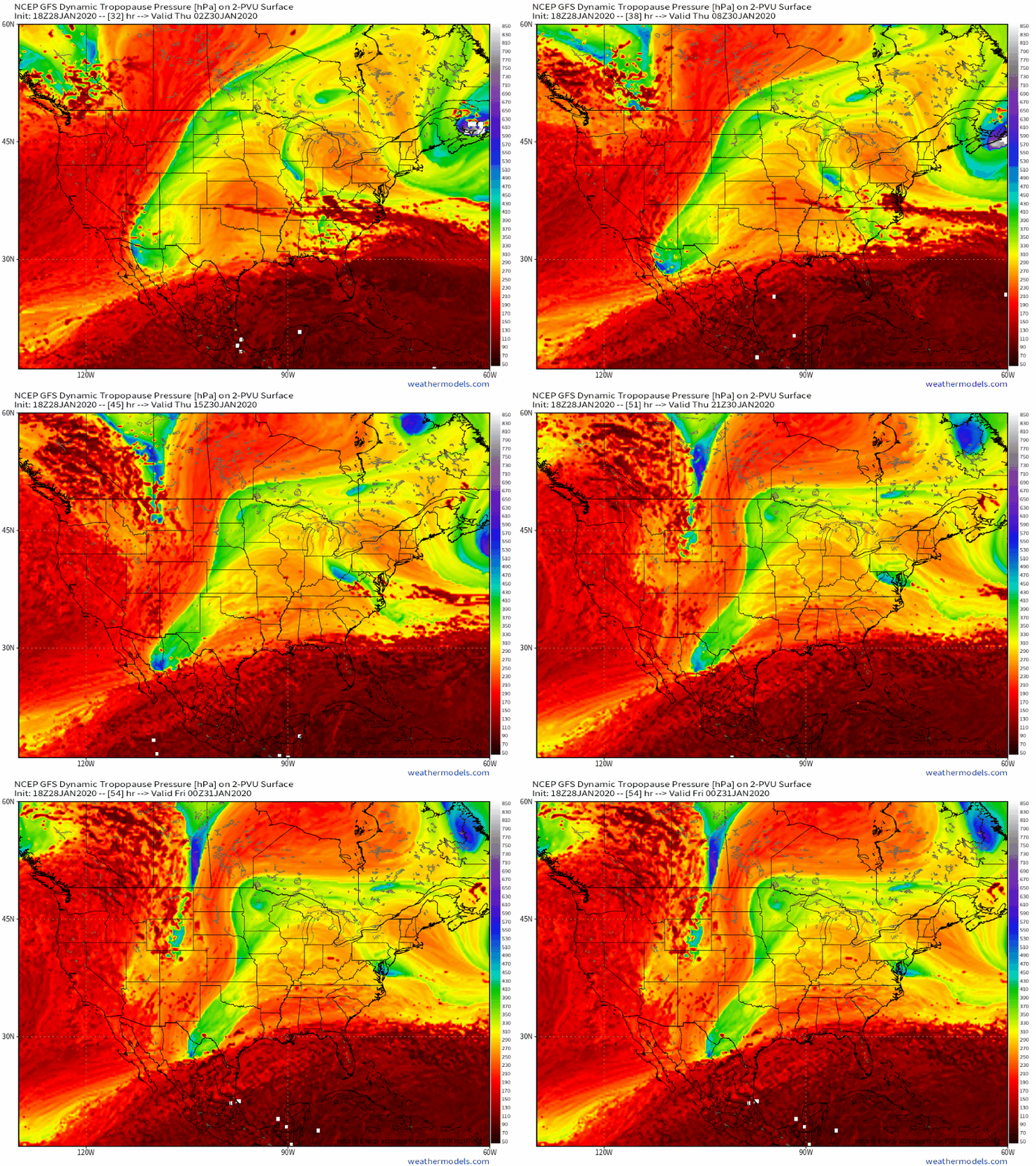
I think the central question surrounding the lead disturbance is how long it dawdles over the mountains of northern Mexico. That phase of its lifecycle is shown here, as depicted by the GFS. The increased friction associated with mountains such as the Rockies is a big stumbling block for model guidance, and I suspect this is among the more important sources of uncertainty regarding the lead disturbance now that it’s onshore.
Unlike the northern stream disturbance where known model biases (associated with issues surrounding the depiction of convection) can be corrected for, thus leaving more room for human correction, I’m not aware of systemic biases for features like this. I know several years ago, the ECMWF in particular struggled with shortwave troughs ejecting out of the Desert Southwest, but I’m not sure to what extent this issue has been fixed in subsequent updates. As annoying as it is, I’m inclined to adopt a “wait and see” approach for the lead disturbance.
So after quite a bit of detailed analysis, what progress have we made towards evaluating the potential for stormy weather along the East Coast next weekend? We’ve identified the likely culprit behind much of the uncertainty associated with the northern stream disturbance’s future track/intensity, and selected a ‘most likely’ outcome based on applicable known model biases. As a result, we’re favoring a more amplified track of the northern stream shortwave which is a necessary but not sufficient condition for the development of a major storm. As far as the southern stream is concerned, we’re still not quite sure how the system will interact with the mountains of northern Mexico which means we’re still not quite sure if a faster (no storm) or slower (storm) solution is more likely.
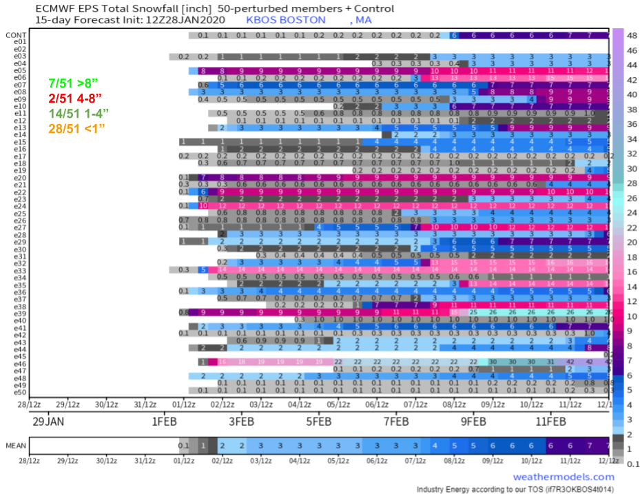
I’ll end this post with a look at one of the graphics we’ve been using to keep track of changing forecasts associated with this storm over the past several days: the EPS individual member snowfall matrix for Boston MA. Interestingly, this afternoon’s ensembles have shifted a bit more in favor of a significant snowfall event or a minimal snowfall event as opposed to something in the more moderate range. Of course the most likely outcome remains the no-impact <1″ scenario.
I think these probabilities make sense in the context of the above analysis. With a stronger/farther south secondary disturbance, the door remains open for a big snowstorm but given how tough it’ll be to get the southern stream disturbance in the right place at the right time, that’s still an outlier scenario. More likely, a weaker storm forms in response to the lead shortwave which will be too fast to get a boost from the secondary disturbance until it’s too late for the US East Coast. In that case, light snow would fall in Boston and adjacent parts of New England.
I’ll keep updating this forecast as more information becomes available over the next few days.
-Jack
