Weak Storm to Bring Rain and Snow to the Northeast This Weekend
Hello everyone!
A weak storm currently moving through the Mississippi River valley will move east over the next couple days before redeveloping off the Mid Atlantic coast this weekend. Light snow is ongoing across parts of the Midwest this morning, and will continue into tomorrow, but this first part of the storm will have relatively minimal impacts. With that in mind, I’ll focus on the coastal redevelopment in this post, as it has the potential to bring heavier snow to interior parts of the Northeast, while coastal areas deal with some gusty winds and potential flooding.
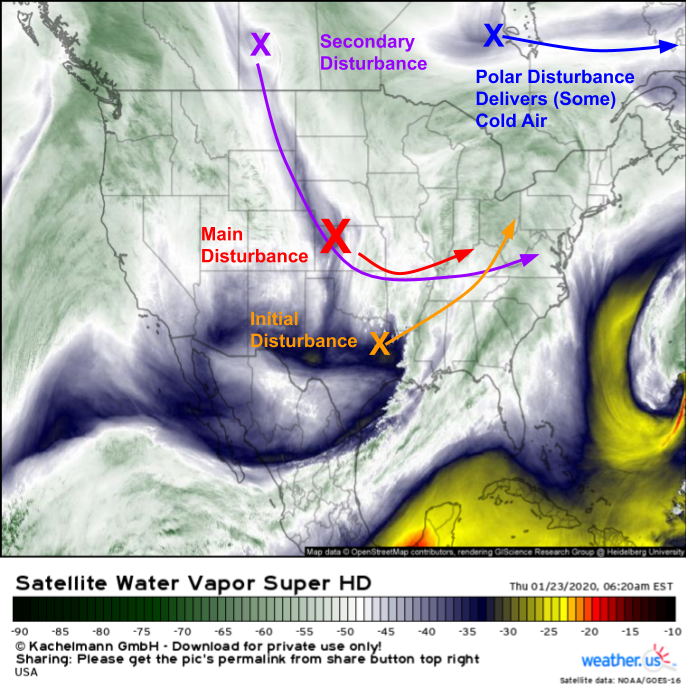
Morning WV satellite imagery from GOES-East shows four upper level disturbances that will work together to bring the upcoming storm together. First, we have a polar disturbance moving east near James Bay. That disturbance will push a cold front through northern New England tonight, setting the stage for wintry precipitation when the main system arrives this weekend. Farther south, two disturbances are noted across the Plains with the first moving through NE Texas and the second diving SE through Nebraska/Kansas. These two disturbances will merge over the Ohio Valley tomorrow afternoon. The surface low associated with this disturbance will also be moving into the Ohio Valley tomorrow afternoon, which means the system will be “vertically stacked”. Once you vertically stack extratropical systems like this one, they lose access to their energy source and begin dissipating. This process will begin later in the day tomorrow as the third disturbance, currently located in Saskatchewan, races SE then E towards the Mid Atlantic.
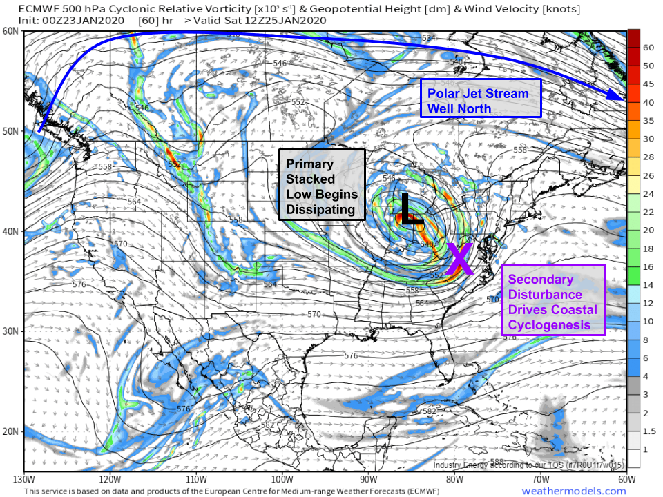
ECMWF 500mb vorticity forecasts for Saturday morning show the closed low beginning to weaken over northern Indiana while that secondary disturbance moves into NC/VA and drives coastal cyclogenesis. Confidence in this process occurring is quite high, though there’s still some uncertainty regarding exactly where that coastal low forms, where it tracks, and how quickly it strengthens. It’s also important to note that the polar branch of the jet stream is displaced well north into Canada. The polar jet separates generally mild mid-latitude air from cold polar/arctic air. We’re firmly on the milder side of that transition zone, which is going to make it hard for snow to fall outside higher elevation areas. Map via weathermodels.com.
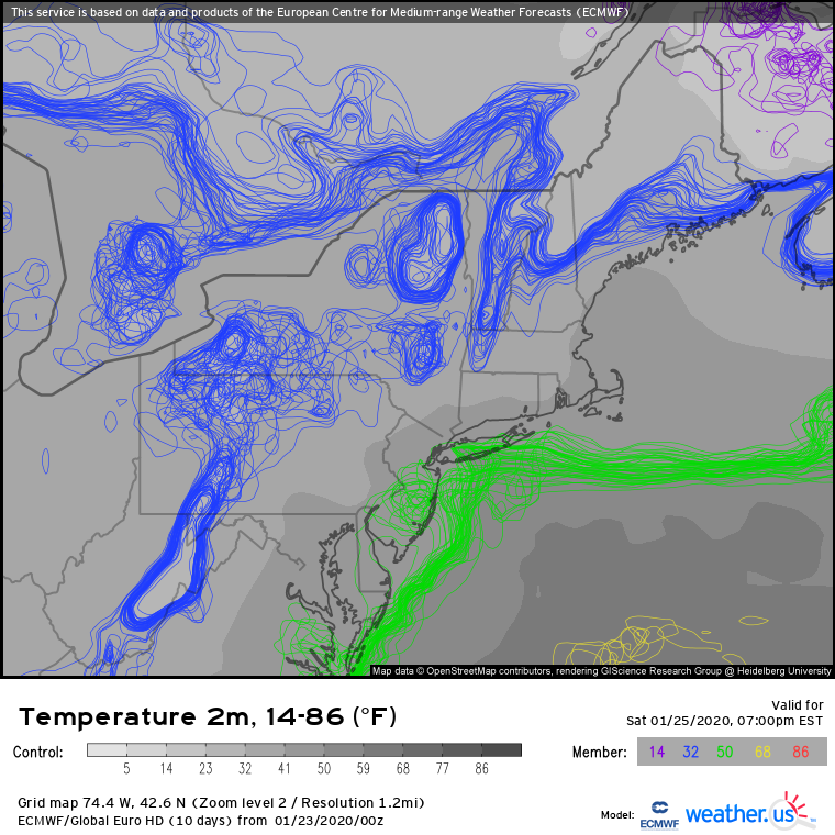
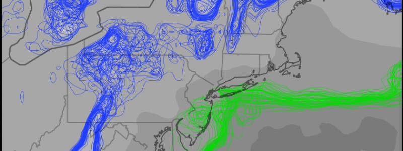
EPS 2m temperature spaghetti forecasts confirm that you’ll need to head to the Catskills, Adirondacks, Greens, Berkshires, Whites, or the mountains of interior Maine to get below 32F while the heavier precipitation falls Saturday evening. There is still some spread among the members, particularly in northern PA, the southern tier of NY, and the CT valley (note in these locations, the spaghetti lines are more jumbled than the orderly lines in WV or offshore). This spread indicates uncertainty related to just how quickly the coastal low can develop and where it might track. A stronger/farther east low would offer colder solutions for the aforementioned uncertain areas, while a weaker/farther west low would be warmer. Note that even the coldest members keep the I-95 corridor above freezing. Therefore, we can safely dismiss any ideas of snow in the big cities.
While snow won’t be a concern along the coastal plain, rain could fall heavily enough to cause some flooding problems. EPS precipitable water spaghetti forecasts show high confidence in a plume of subtropical moisture surging into the Northeast on Saturday afternoon ahead of the developing coastal low. This moisture, combined with the lift associated with the secondary upper level disturbance and developing surface low, will support a band of heavy rain. How strong that band ends up being is still a bit uncertain (remember we aren’t quite sure yet how strong the coastal low will be), but if it ends up on the stronger side, some urban/small stream flooding would be possible in the NYC/SNE area.
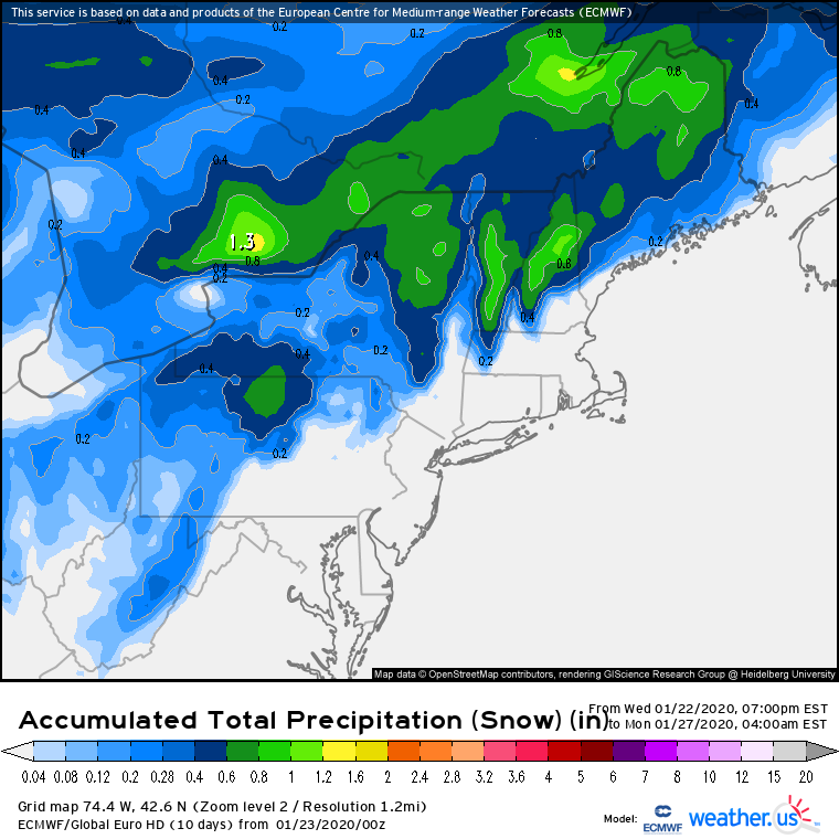
Here’s the ECMWF’s forecast for how much liquid-equivalent precipitation will fall as snow during the upcoming event. Given the lack of cold air, it’s unsurprising that the best chance for >6″ totals (green shadings) will be found in the Adirondacks, Greens, and Whites. I think the model might be a bit optimistic about how much snow falls in N PA, but even if that much liquid did fall as snow, the ratios there would be significantly lower such that .6″ of liquid equivalent falling as snow might only produce 3-4″ of accumulation. For more on how this whole “liquid equivalent” map works, check out this tutorial video.
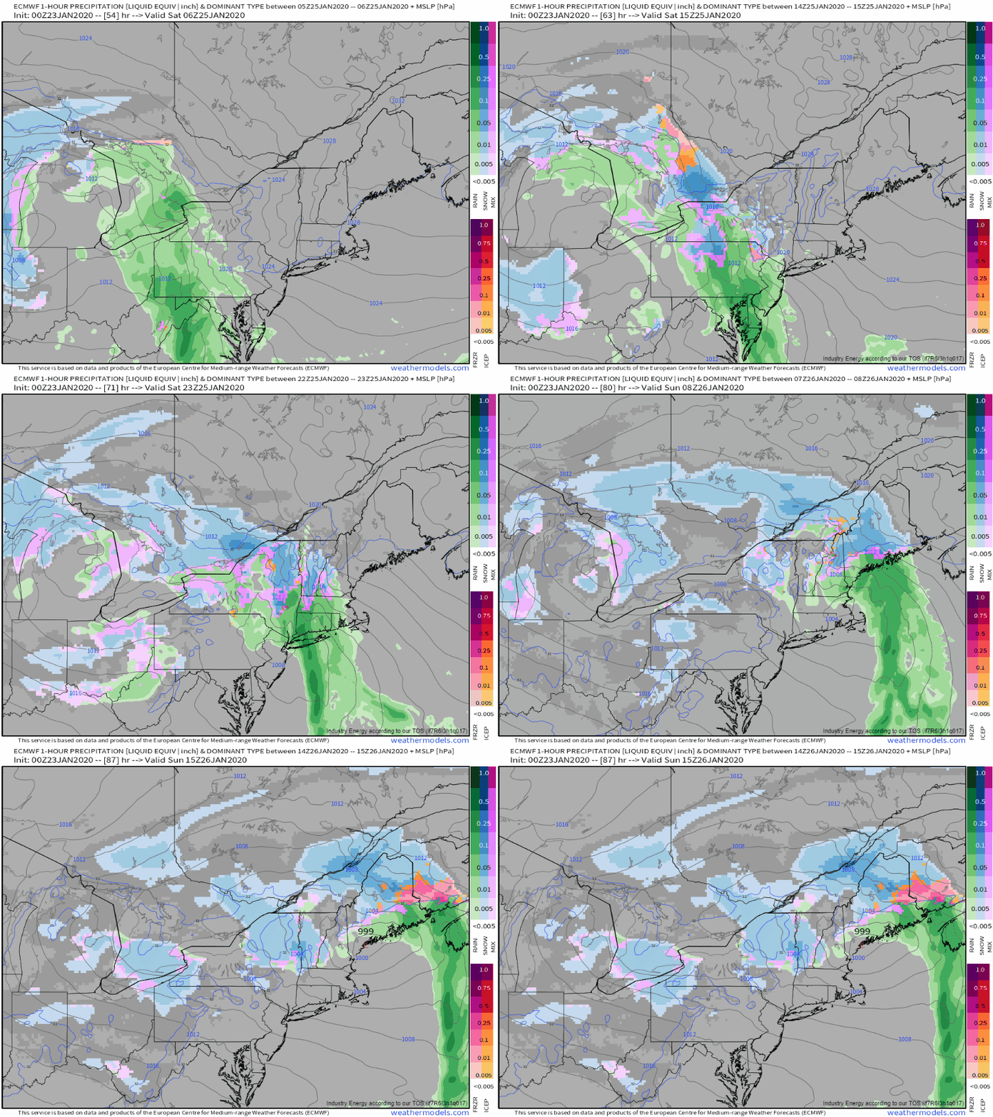
I’ll wrap this post up with an animation of the ECMWF’s hourly precipitation type/surface pressure forecast for the upcoming storm. You can clearly pick out the snow in interior areas and the band of heavy rain marching up the I-95 corridor as discussed above. You might also notice that this system’s precipitation field appears to be a bit more scattered than most storms. That’s simply because without any involvement from the polar jet stream, this storm only has so much energy to work with. The energy that is available will end up focused in that narrow band of heavier precipitation associated with the coastal low, but that low won’t deepen quickly enough to produce an expansive precipitation shield. GIF via weathermodels.com.
Overall this system doesn’t look to bring major impacts, though travel could be tricky for a brief time as that band of heavier precip swings through.
Follow us @WeatherdotUS and me at @JackSillin on twitter for more frequent updates as the storm gets closer.
-Jack
