Unusual Cold Snap Impacting Florida This Morning
Hello everyone!
An unusually strong cold snap is underway across the state of Florida this morning as a deep upper level trough passes over the state. This post will take a quick look at the meteorological conditions that have allowed temperatures to drop below freezing across the northern half of the state and below 40 as far south as Miami. I’ll also try to put the cold snap in some historical context and take a look at the forecast to see how long the cold will stick around.
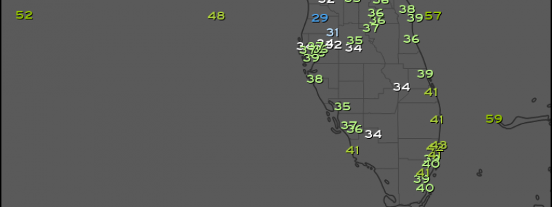
Observed temperatures as of 6 AM EST show just how cold it’s gotten across the entire state of Florida. Subfreezing temps have nearly made it to Tampa while temps barely above freezing (supportive of frost) have been observed as far south as the area just inland from Naples FL. Temps in the 30’s have made it all the way to Miami! So why is it so cold?
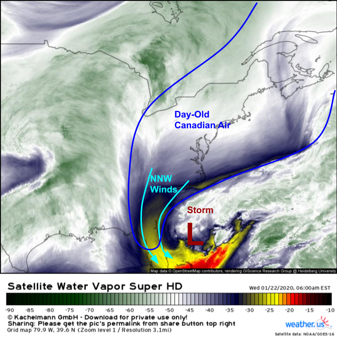
The Canadian airmass over the East Coast this morning is actually far from impressive. It’s been sitting over the East Coast for the past couple days (hence “day-old”) which means that it’s been modified and thus has lost some of its original cold. However, an upper level disturbance that moved off the coast of FL yesterday has prompted the rapid development of a strong offshore storm which shows up clearly on GOES-East WV imagery this morning. Unusually strong NNW winds behind that storm have been able to push Canadian air much farther south than it can usually make it if only being pushed by a high pressure system over the Plains (the usual pattern that brings cold air to Florida). That storm is the reason that an otherwise-unimpressive Canadian airmass is able to bring such cold temps to Florida.
Now that we know what’s causing the cold, how does this event fit into the state’s climatology? It’s fairly typical for subfreezing temps to make brief appearances in the northern part of the state, but usually Miami and surrounding parts of SE FL don’t get to experience those cold airmasses.
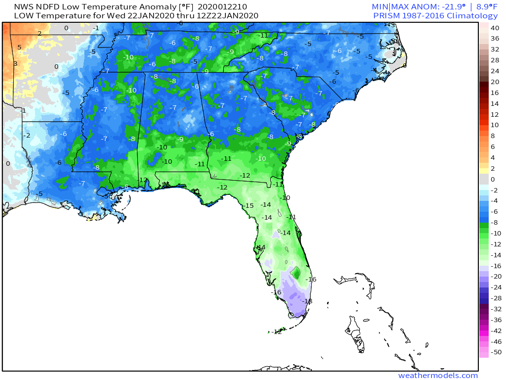
Forecast anomalies for this morning’s low temperature highlight the climatological pattern I mentioned above. Note that low temps over the Southeast (MS/AL/GA/SC/etc.) are below normal, but only by 5-10F. This airmass is “seasonably cool” for that region, which means that you typically expect a few of these each year. It’s on the chillier side of “normal”, but far from unusual. This is also the case for the Florida Panhandle, though the anomalies are a bit larger there. Once you get south of Orlando however, you’ll notice anomaly values starting to get into the 15-20F range. For an area with so little climate variability (due to proximity to so much water), a 15-20F temperature anomaly is a big deal! Map via weathermodels.com.
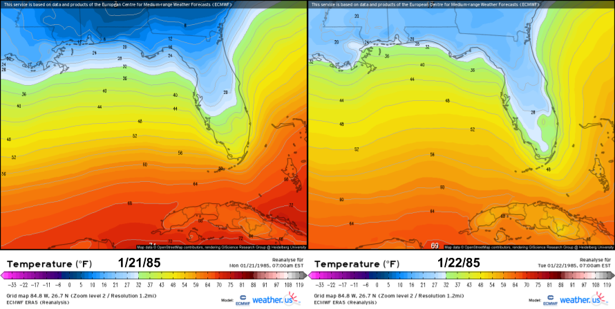
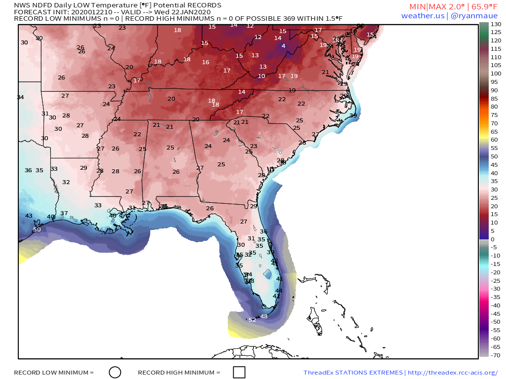 That said, not a single station in the Southeast or Florida is expected to set or nearly set a new daily record low temperature. While this cold air outbreak is impressive, it has nothing on the January 21-22, 1985 event! Map via weathermodels.com.
The 1985 event brought single digit temps to the Panhandle of Florida while subfreezing air made it all the way to Miami (the airport recorded a low temperature of 30F!). Farther north, the cold was even more impressive. Much of northern Georgia and Alabama fell below 0 along with wide swaths of NC and VA. There were profound impacts from this event including school closings, record electricity demand, and a flurry of fires caused by the improper use of space heaters (you can read more about the 1985 event and its impacts here).
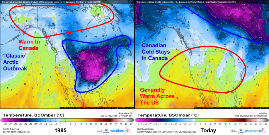
Meteorologically speaking, the 1985 event was quite different than the one we’re experiencing now.
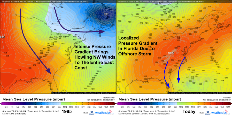
In fact, even a cursory comparison of the large-scale pattern today to the large-scale pattern in 1985 shows that the two events are almost completely opposite. In 1985, we had a classic Arctic outbreak with warm air up in Canada, and some of the coldest air in the entire Northern Hemisphere located over Kentucky and Ohio. Today, the Arctic air is bottled up where it belongs- in the Arctic. Meanwhile, fairly warm air is present in the lower atmosphere across the US. However, if you look closely enough on today’s map, you’ll see a small appendage of cold air extending southwestward from Newfoundland down towards Cape Hatteras. That’s the “day old” Canadian airmass I talked about above.
At first glance, the surface maps for the two events look pretty different too. In 1985, we had an intense storm over the Gulf of Saint Lawrence and a massive area of Arctic high pressure crawling down the Plains. Today, we have our stale Canadian high over the Mid Atlantic with a weak storm off the Bahamas. However, a closer comparison reveals isobars packed fairly tight over Florida with higher pressure to the north and lower pressure to the south/southeast. The pressure gradient today is actually fairly similar to that in 1985 if you only count Florida in your analysis. As a result, we’ve been able to push unusually cold air into Florida even though prevailing conditions across the Eastern US more generally are fairly mild.
Weather maps from the 1985 event are available on the ERA5 reanalysis page at weather.us.
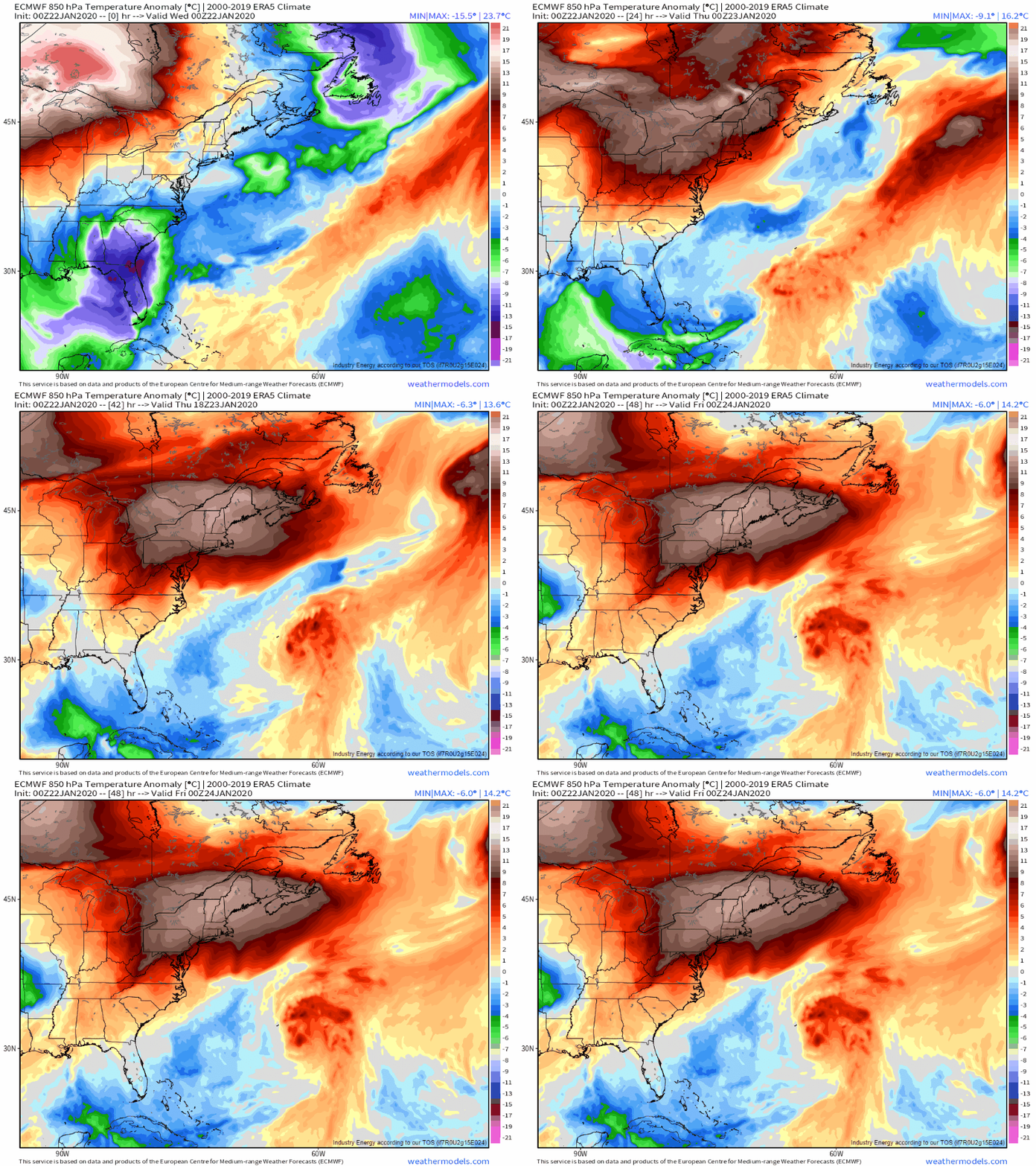
How long will the cold last? ECMWF forecasts of low level temperature anomalies suggest that the answer is ‘not very long’. The offshore storm currently pushing that cold air into Florida will move towards Bermuda tonight/tomorrow, and without a continuous supply of new cold air from the north, the airmass will quickly warm up over the Gulf of Mexico and adjacent parts of the SW Atlantic. Enjoy the cold air while it lasts, Floridians! GIF via weathermodels.com.
Unsurprisingly, near-freezing temperatures in Florida (particularly southern Florida) bring a different suite of impacts than most other parts of the country.
Yesterday, the NWS office in Miami issued a forecast warning residents to be aware of the potential for falling iguanas. Apparently, the cold-blooded animals become lethargic when it gets too cold (below ~40F) and can fall from their perches in trees as a result.
This morning, NHC forecaster Eric Blake provided ground-truth verification of the falling iguana forecast.
With that in mind, bundle up and keep an eye to the trees if you’re headed out in Florida today!
-Jack

