Next Major Storm Set To Develop Across The Plains On Friday
Hello everyone!
After a quiet start to the new year, the next major storm system to impact a wide swath of the country is set to develop across the Plains on Friday. This post will provide an overview of this storm including why it’s expected to track where it will, how strong it might be, and some of the general impacts we’ll be watching for. Detailed analysis of specific impacts (severe weather, heavy snow, flash flooding, etc.) will most likely be posted tomorrow evening.
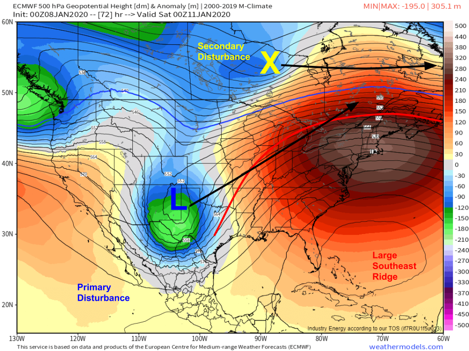
Here’s the general pattern forecast for Friday afternoon by the ECMWF model, which is supported by other available model guidance and an analysis of the pattern based on WV satellite imagery. A strong upper level disturbance currently over the Rockies will emerge onto the Plains over Texas on Friday evening. Strong upper level divergence ahead of this disturbance will support the development of a surface low over Oklahoma during this time. Strong warm air advection ahead of this system combined with other hemispheric-scale forcing will result in the development of an extremely strong ridge anchored over the southeastern US/southwestern Atlantic. This ridge will force the Texas disturbance to track through the Central Mississippi Valley before moving into the Great Lakes. A second disturbance is noted across Ontario, and will work to chip away at the northern periphery of the ridge as it slides east into Quebec. This disturbance will be important to the forecast for Northern New England, but otherwise is of little consequence to the storm’s overall evolution. Map via weathermodels.com.
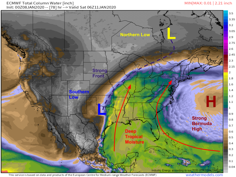
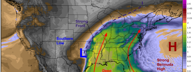
The most unusual aspect of this storm will be the amount of moisture it will be able to tap into as it moves from Texas to Michigan this weekend. Strong south/southwesterly flow through a deep layer of the atmosphere from will be supported by an unseasonably strong Bermuda High will push tropical moisture from the Caribbean and Gulf of Mexico well north into the Ohio Valley. As a result, there will be plenty of heavy precipitation associated with this storm including heavy snow and mixed precip where temps are cold enough. Map via weathermodels.com.
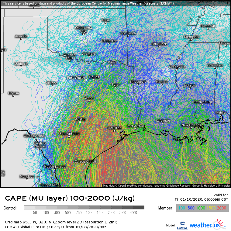
That tropical moisture will also help set the stage for severe weather on the southeastern side of the storm. EPS members are in remarkable agreement that a plume of unstable air with CAPE >1500 J/kg will develop in eastern Texas on Friday evening as the storm develops in Oklahoma. As the storm’s cold front moves east and forces that unstable air to rise, storms will develop and are likely to become quite strong given the available energy, both thermodynamically (shown above) and kinematically as strong winds throughout the column produce abundant wind shear. Severe storms are also likely across parts of the Southeast on Saturday. Both severe weather setups will be discussed in more detail tomorrow evening.
As far as the colder side of the storm goes, this doesn’t look to be a prolific producer of heavy snow thanks to the general lack of cold air across the US this week. A stripe of light to moderate snow is expected to the northwest of the storm’s track, with the best chance for substantial accumulations >3″ over the Great Lakes from eastern Wisconsin into the northern part of Michigan. Perhaps more significant will be the stripe of icy mixed precipitation that falls along the southeastern periphery of the snow highlighted above. As with the severe weather, a more detailed discussion of the ice/mixed precip threat will come tomorrow night. Map via weathermodels.com.
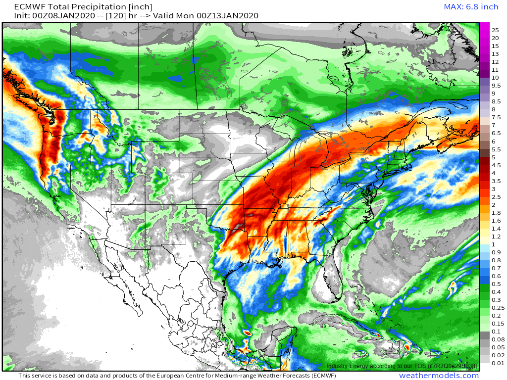
It will also be good to keep an eye on the potential for flooding given the amount of moisture available to this system. ECMWF precipitation forecasts show a large area of rainfall totals in the 2-4″ range, which shouldn’t be enough for major river flooding issues, but will trigger rapid rises on small streams. Localized flash flooding is also possible with thunderstorms that develop over NE TX/SE OK/AR on Friday, and northern MS/AL on Saturday. Map via weathermodels.com.
After developing over the southern Plains on Friday and reaching peak intensity over the Ohio Valley on Saturday, the storm will weaken as it moves through the Northeast on Sunday. Aside from some gusty showers along the cold front which may include some rumbles of thunder, the main impact in the Northeast will likely be icy mixed precipitation in the mountains of Northern New England. Any snowfall accumulations of significance will be confined to northern Maine. GIF via weathermodels.com.
You can easily follow along with forecasts for this storm in your town by going to weather.us and typing your town’s name into the search box. I’ll have more detailed discussions of specific impacts tomorrow evening.
-Jack
