Taking A Closer Look At The Potential Northeast Ice Storm Forecast To Begin Tonight
Hello everyone!
The large and complex storm system we’ve been watching for several days now is well underway across the Plains, and its impacts are quickly spreading east. I’ve written about this system’s many impacts in varying degrees of detail (roughly proportional to impact severity) in previous blogs, but it occurred to me today that the potential for a destructive ice storm across parts of western New England and upstate New York is deserving of a closer look. This post will closely examine the forecast for this area and will include a detailed discussion of why so much ice could accumulate on trees/power lines as well as what factors might be able to keep accretion down a bit.
This is a graphic I made yesterday morning, but it does a good job highlighting the overall setup including why we’re talking about freezing rain in the first place. As low pressure moves into the Great Lakes, southerly winds on the southeastern side of the storm will be pushing warm air northward towards New England. Meanwhile, strong high pressure over Quebec will be pushing cold air south, also towards New England. The higher density of cold air relative to warm air means that the cold will be in control closer to the ground while the warmth will have the upper hand aloft. When a layer of warm air is present aloft, falling snow melts into rain. If that rain falls into subfreezing air very near the surface, it can freeze on contact with cold objects on the ground including trees and power lines. This “warm over cold” setup is the basic reason why freezing rain is in the forecast for parts of NY and western New England tomorrow.
While it’s relatively easy to look at the overall setup and say that freezing rain is likely, it’s a much more challenging problem to figure out exactly where ice will accumulate and how much will end up on trees and power lines.
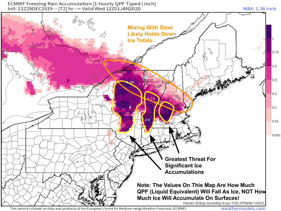
The first step to figuring out where ice will accumulate and how much might end up sticking is to take a look at how much liquid-equivalent precipitation is expected to fall as freezing rain. That’s what this “freezing rain accumulation” map shows (not how much ice will actually accumulate on any given surface!). A closer look at temperature forecasts for different levels in the atmosphere indicate that the cold air will be deep enough over central NH and central VT for some sleet to mix in along with the freezing rain. This will be especially true for lower elevations, as the cold layer won’t be deep enough to refreeze raindrops before they hit the higher terrain. Farther southwest, cold air will hang on at the surface in the Catskills, Poconos, and Berkshires while a much deeper layer of warm air moves in aloft. That means that the risk of significant freezing rain accumulations is greater in these areas relative to areas farther to the northwest.
In general, freezing rain accumulates at a rate of about 1/3″ ice per 1″ of liquid falling as freezing rain. Therefore, a rough guesstimate of ice accretion amounts can be made by multiplying the values you see on the map above by 1/3. However, that assumes “normal” accretion conditions, and a good forecast by the ECMWF model of how much QPF will fall as ice. Neither seems to be the case for this event.
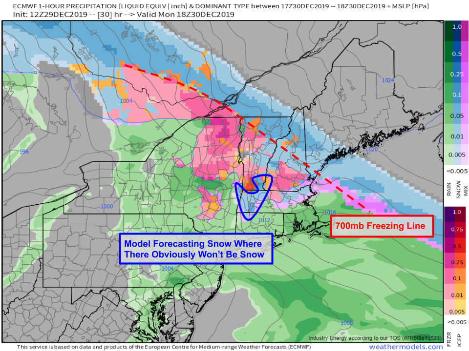
First of all, the algorithm the ECMWF model uses to determine which precipitation will fall as rain/snow/sleet/freezing rain seems to be having some trouble with this system. For example, the model is showing light snow over the Berkshires and southern Green Mountains midday on Monday while also predicting temperatures near 40 around 10,000 feet above the surface. If you loop through the precip type and temperature forecasts on weather.us or weathermodels.com, you’ll notice this issue persists for a good chunk of the day on Monday before colder air really does move in from the west, which could support a brief switch back to snow. By doing a quick double check of the model’s algorithm for physically impossible conditions (snow with a deep layer of warm air aloft), we’ve already spotted a major error that will have significant impacts on its predictions for ice accretion. It’s more likely that the vast majority of the 1.75-2″ liquid-equivalent precipitation will fall as freezing rain across the Catskills, Berkshires, and adjacent higher terrain of NW CT and southern VT. Using our 1/3:1 ice:liquid ratio rule of thumb, that puts us at a ballpark .5-.75″ of ice accretion for our areas of interest. But how might actual accretion differ from the rule of thumb?
Ice accretion is impacted by a variety of factors, but the most important are the surface air temperature, precipitation rate, and wind speed. It’s fairly clear why the air temperature would be important, but why would precipitation rate and wind speed matter? As the rain freezes on contact with the ground or objects near the ground, latent heat of fusion is released. This is because the water is going from a higher energy state (liquid) to a lower energy state (solid), and the excess energy must go somewhere (into the air). Each drop doesn’t release all that much latent heat, but the latent heat released by the billions (trillions?) of drops that fall over a whole mountain range during several hours of freezing rain is more than enough to bring the temperature up to freezing and prevent additional ice accretion. This effect can be offset if colder air is continually supplied via horizontal advection (transport horizontally from somewhere not experiencing freezing rain). That’s where the wind speed becomes important. Stronger winds help disperse the latent heat released by the freezing raindrops, and when they are blowing from a colder source region (as is forecast tomorrow), the resulting advection of colder air can keep temperatures cold enough for freezing rain despite the release of latent heat. When precipitation becomes too heavy, even strong cold air advection won’t be enough to offset the latent heat release. Therefore, lighter precipitation rates are much more conducive to ice accretion than heavier precipitation rates.
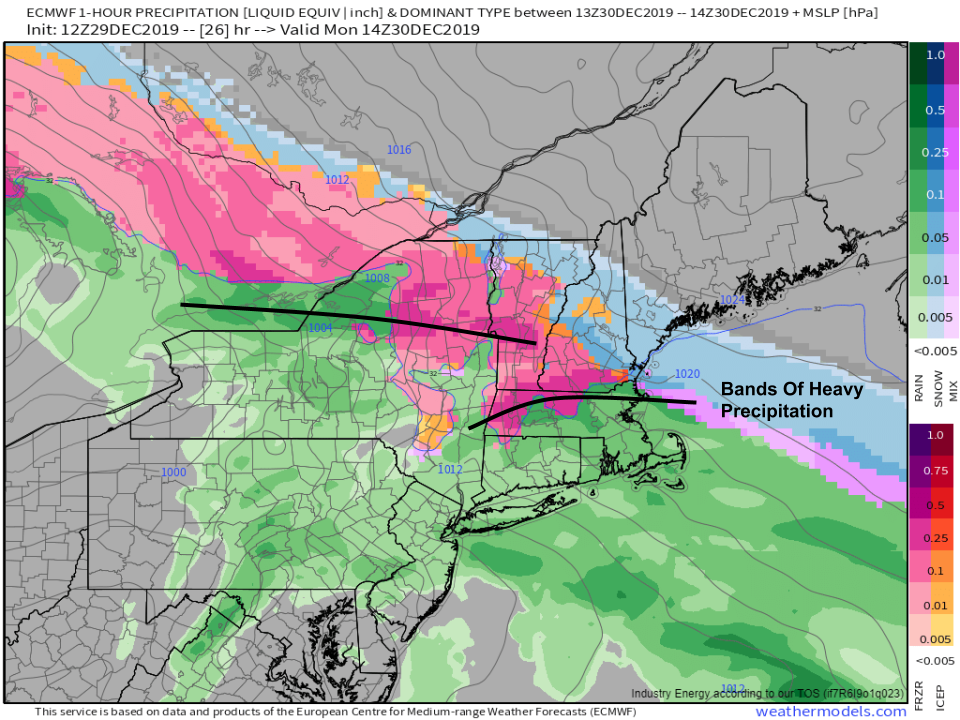
Some bands of heavier precipitation will move through on Monday morning, but overall this event looks to feature a lot of steady light/moderate precipitation as forcing for ascent north of the warm front is generally provided by isentropic uplift, and thus not all that rapid. With regards to the precipitation rate term of the informal ice accretion equation we’ve constructed, we can adjust our forecast for ice accretion a bit upward owing to the lack of sustained heavy precipitation.
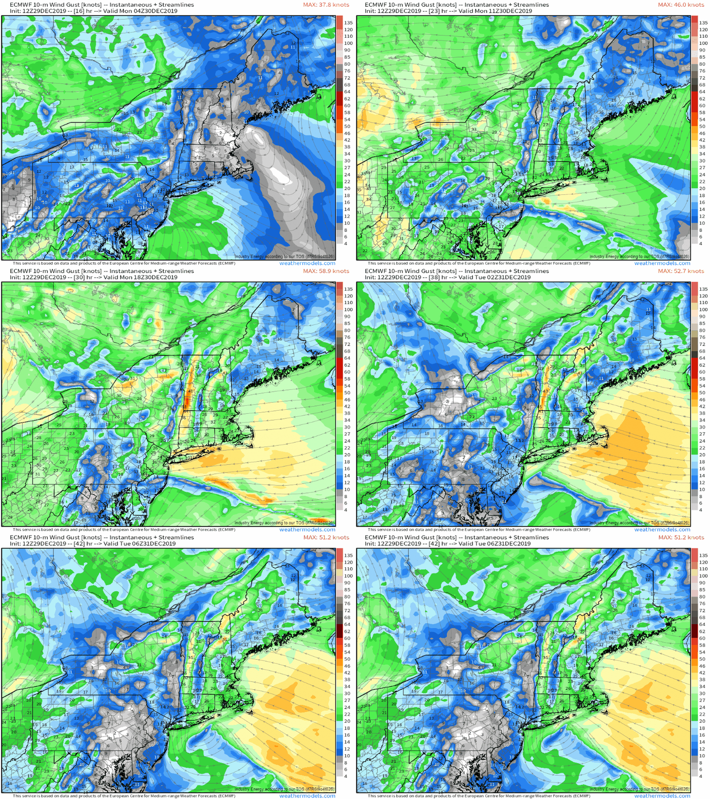
We’ll also have no shortage of cold winds as high pressure remains firmly established in southeastern Quebec and a secondary area of low pressure develops off the New Jersey coast. In the higher terrain of MA and VT, gusts over 35 mph will be common which will not only help ice accumulate more efficiently, but will also contribute to additional power outages from falling tree branches. Due to the steady ENE breeze bringing cool air into the region from Canada and helping disperse latent heat released by the freezing of raindrops on cold surfaces, another upward adjustment from the rule of thumb is in order.
One other factor that contributes to the efficiency (or lack thereof) of ice accretion is how cold surfaces are before the onset of precipitation. It’s easier for raindrops to freeze on a very cold surface than a relatively warm surface.
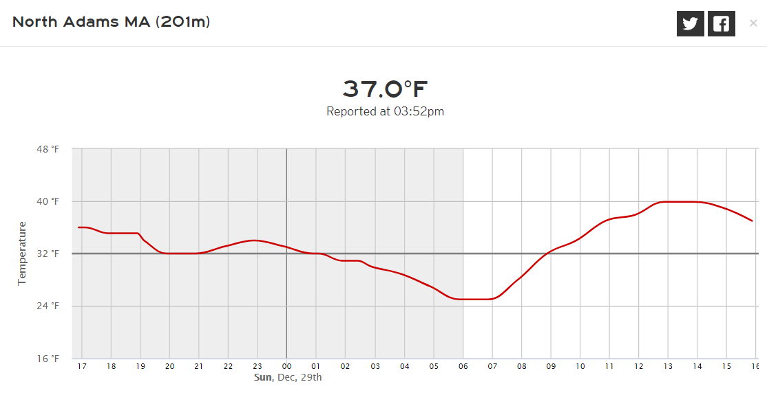
After dipping into the mid 20’s last night, most locations in the Berkshires and Catskills have spent much of today in the mid to upper 30’s under mostly sunny skies. Temps over the past few days have also been relatively warm, with highs above freezing each afternoon. The net result is that the trees and power lines we’re worried about ice accumulating on are starting off above freezing. With that in mind, it will take a little while for surfaces to cool off enough to support ice accretion which means some of the freezing rain that falls at the beginning of the event tonight and early tomorrow morning will have a very hard time accumulating. This may help counteract some of the forces discussed above that are pushing for more efficient accretion.
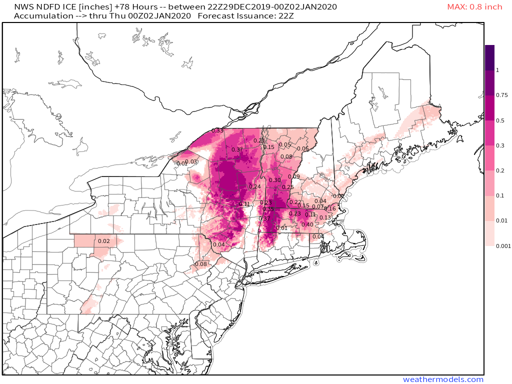
The NWS forecast produced by meteorologists who have analyzed the aforementioned data (plus much more!) looks pretty consistent with our general expectation starting with the 1/3:1 rule of thumb and adjusting a little upward in light of generally light/moderate precipitation rates and steady ENE breezes. Also note the lower amounts over central NH and central VT where sleet is expected to hold down ice totals. The “jackpot” for ice accretion from this storm looks to be found in the Berkshires and Catskills where around 3/4″ of ice is expected. Some localities may be able to approach the 1″ mark if all goes well (or poorly, depending on how much you value electricity). The Adirondacks and hills of NW CT will see around or a little over 1/2″ of ice with lighter but still substantial amounts above 1/4″ in SW NH and the Worcester hills.
Generally speaking, ice accretion in excess of 1/2″ will result in tree/power line damage, though that threshold will likely be a tad lower in this event due to the breezy ENE winds which will add additional stress to fragile branches and infrastructure. If you live in the areas highlighted above, be prepared for extended power outages!
-Jack

