Thanksgiving 2019 Travel Forecast
Hello everyone!
We’re now just a few days away from Thanksgiving, and many folks are preparing to hit the road to visit friends and family for the holiday. This post will outline where and when to expect weather-related travel disruptions for the trip to your Thanksgiving destination. I’ll have another blog in a few days to discuss the forecast for your return leg. Of course, I can’t cover every possible disruption nor can I be extremely precise in my discussion here (we have a lot of ground to cover!) but hopefully this post can serve as a “first look” to see if your plans might be impacted. If the answer is yes, I’d suggest further investigation into the forecast over at weather.us and weathermodels.com..
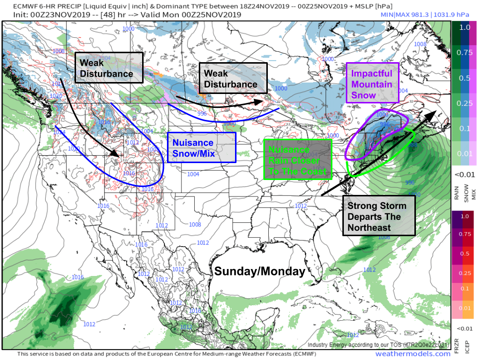
If you’re departing tomorrow or Monday, you shouldn’t run into too much trouble weather-wise. A seasonably strong storm will impact the Northeast, but with cold air in short supply, precipitation will take the form of nuisance rain for the hubs of Boston, New York City, and DC. Some delays are possible, but widespread issues are not expected. If you’re driving through the New England mountains though, watch out for snow-covered roads. Two weak disturbances will bring light snow/mixed precip to parts of the Northern Plains and Rockies, but substantial travel disruptions are not expected. Map via weathermodels.com.
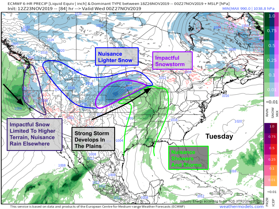
The Rockies disturbance will slide into the Plains on Tuesday, and a seasonably strong storm will develop in response. While there’s still some uncertainty regarding the system’s exact intensity and track, an impactful snowstorm is likely for parts of the Central Plains from NE Colorado through Nebraska into NW Iowa and SE South Dakota. If your travel plans take you through these areas on Tuesday, pay close attention to the forecast and be ready for substantial delays. The southern side of this storm doesn’t look too bad, and while some nuisance showers will wet the roads in the Mississippi River valley, no major impacts are expected. Farther west, a strong storm will begin developing off the California coast. This will bring heavy snow to the Sierra and Coastal mountain ranges, with rain expected closer to sea level. If you’re flying to/through the West Coast, I wouldn’t expect major impacts to your travel plans, but if you’re headed through the passes, plan on taking some extra time. Map via weathermodels.com.
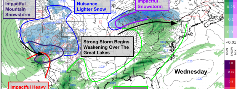
The Plains storm will begin weakening on Wednesday as it moves into the Great Lakes. Heavy snow will impact parts of SE Minnesota, Northern Wisconsin, and the UP of Michigan, and substantial travel delays are likely in these areas. As with Tuesday, the southern side of the storm looks pretty tame, and no organized heavy rain or severe weather is expected at this time. Farther west, the California storm will be in full swing on Wednesday with heavy mountain snow and lower elevation rain. There may be a substantial enough overlap of deep moisture and strong dynamical forcing (upward motion) over Southern California to promote heavy rain capable of some flash flooding and burn scar landslides. If your travel plans take you through this area, keep an eye on forecasts and be ready for substantial delays. Map via weathermodels.com.
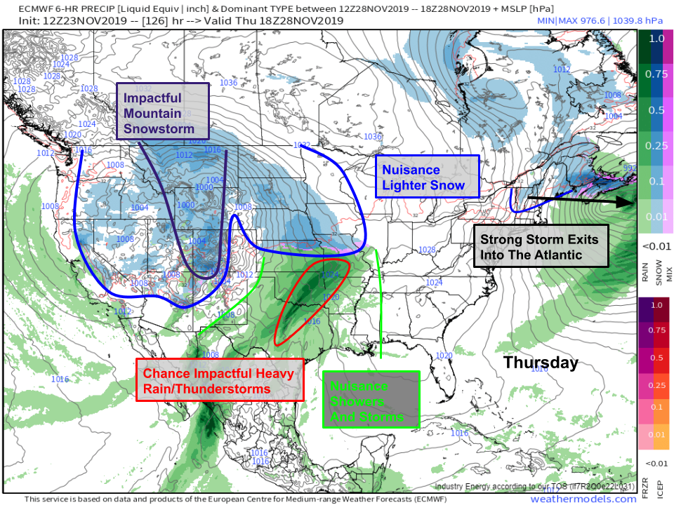
By Thursday, the Great Lakes storm will have exited into the Atlantic leaving fair but cool weather in place across the Northeast and Midwest. The California storm will be moving through the Rockies, spreading rain and snow into the Plains. The details of this storm’s evolution become a bit fuzzy by Thursday, but it’s not impossible to think that there will be enough moisture around in parts of Texas and Oklahoma to support some impactful heavy rain (minor flooding issues) and perhaps some strong thunderstorms as well. There’s more confidence in the cooler side of the storm, and light/moderate snow is likely to develop from the Dakotas down towards the Kansas/Nebraska border. Heavier snow will be possible up in the Rockies from Montana down to Colorado. If your travel plans take you into these areas, I’d advise arriving on Wednesday if possible. Farther west, rain and snow will be tapering off in California as drier air moves in from the north. Map via weathermodels.com.
As I mentioned at the beginning of this post, you can find more specific info for cities and areas of interest to you at weather.us and weathermodels.com. Overall, this Thanksgiving travel season looks to be about average as far as weather disruptions go. It’s hard to get a completely benign weather pattern for a whole week in November!
-Jack


