Tropical Disturbance To Bring Flooding Rains To Texas, Humberto Still Expected To Remain Well Offshore
Hello everyone!
We have two tropical entities to watch closely today, with a couple others on the backburner out in the middle of the tropical Atlantic. This post will focus on those that are of more immediate interest. The first system to watch is a tropical disturbance in the NW Gulf of Mexico. While it will not have enough time over warm water to develop before arriving in Texas tomorrow, it has plenty of moisture and lift to produce flooding rains as it moves ashore. The second system is Hurricane Humberto which has now turned NE off the Florida coast. The system is still expected to remain far enough offshore to prevent major impacts, but high seas and rip currents will continue to be a problem along the East Coast this week.
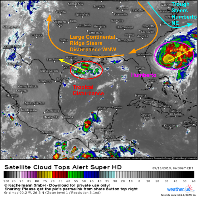
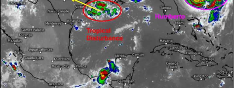
Satellite imagery of the Gulf of Mexico region shows both systems clearly this morning. Humberto is near the eastern edge of the picture, being steered ENE by a trough of low pressure over the Northeastern US. The tropical disturbance meanwhile is located ESE of Houston and is being steered WNW by a large ridge of high pressure currently bringing unseasonably hot weather to much of the Deep South. Note that while the disturbance doesn’t have a very organized satellite presentation, it does have a decent cluster of thunderstorms associated with it. That cluster of storms will be dropping some very heavy rain as it moves inland over the next few days.
Gulf of Mexico Disturbance
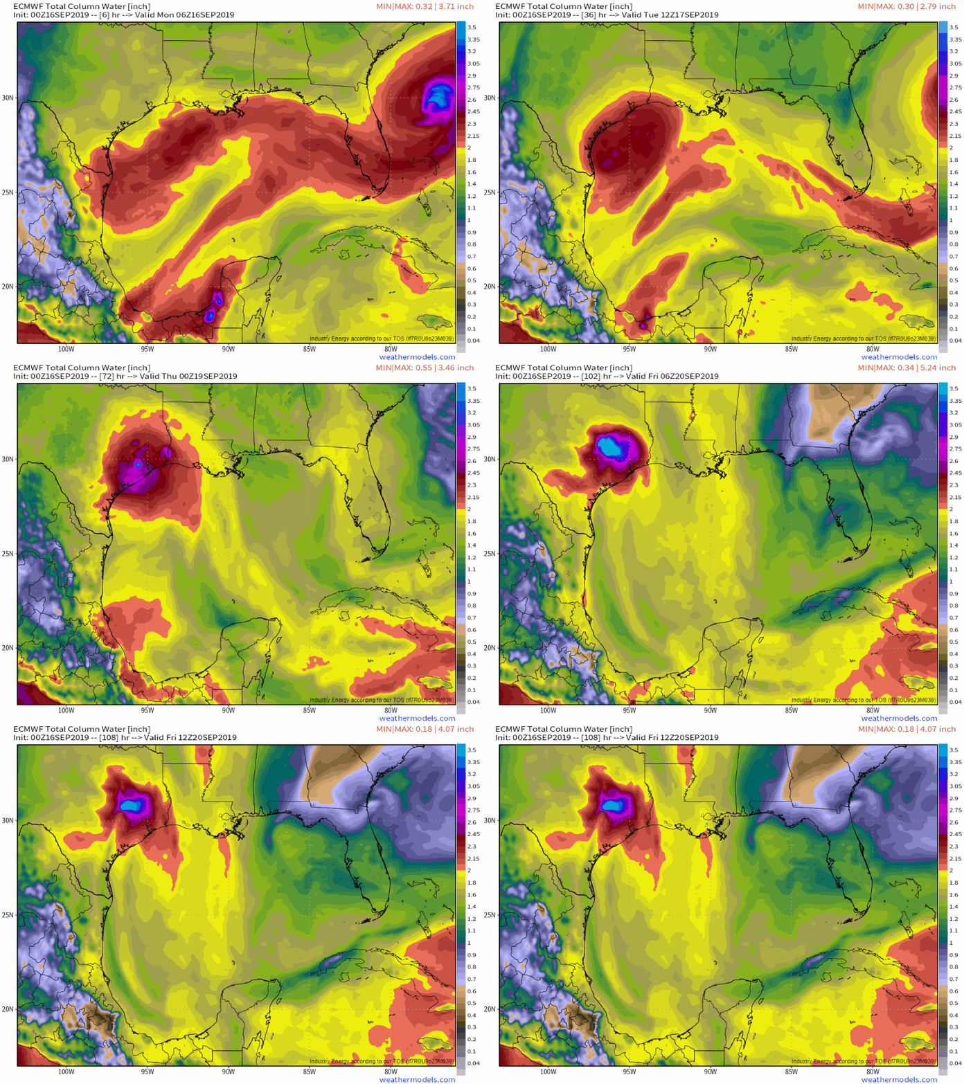
The ECMWF’s precipitable water forecast for the next couple days does a good job showing the disturbance’s pool of very moist air moving onshore. Precipitable water values above 2″ are generally supportive of very heavy rain and flash flooding (though are not a perfect predictor, as there can be flash flooding with lower PWAT values or calm weather with higher PWAT values). SE Texas will exceed that 2″ threshold by tomorrow which will mark the beginning of the more substantial flash flood threat. GIF via via weathermodels.com.
That being said, moisture in the air won’t do much in terms of flooding by itself, there needs to be a mechanism for air to rise and cool, thus letting the moisture condense into raindrops.
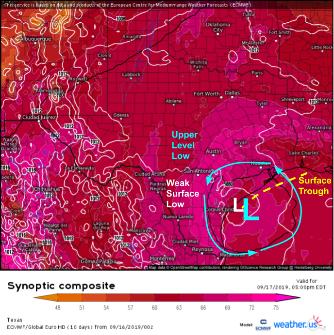
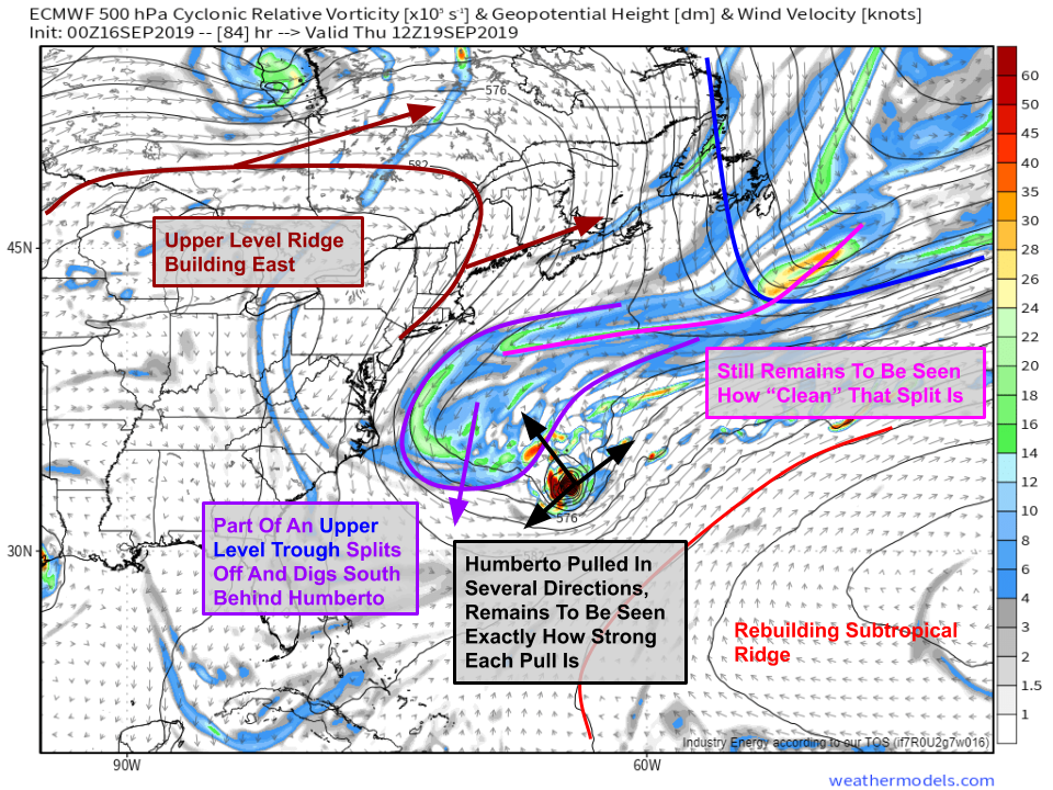
This lift will come from the combination of a weak surface low/associated trough of lower pressures extending off to the NE and an upper level low located over roughly the same area as shown by the synoptic composite map above. The upper level low will work to get air rising on the larger scale, while convergence associated with the surface trough near the coast will help focus thunderstorm activity along the coast near Houston tomorrow evening.
The result will be rain totals steadily increasing over SE Texas beginning tomorrow and extending into Wednesday. It’s far too early to establish what exact totals might be in a given town as that will depend on where exactly individual thunderstorm cells develop and track. However, residents of the Houston area should be prepared for at least several inches of rain, while also recognizing that the possibility exists for more. If your area floods during heavy rain events like this, now is a good time to be preparing for high water. GIF via weathermodels.com.
Humberto
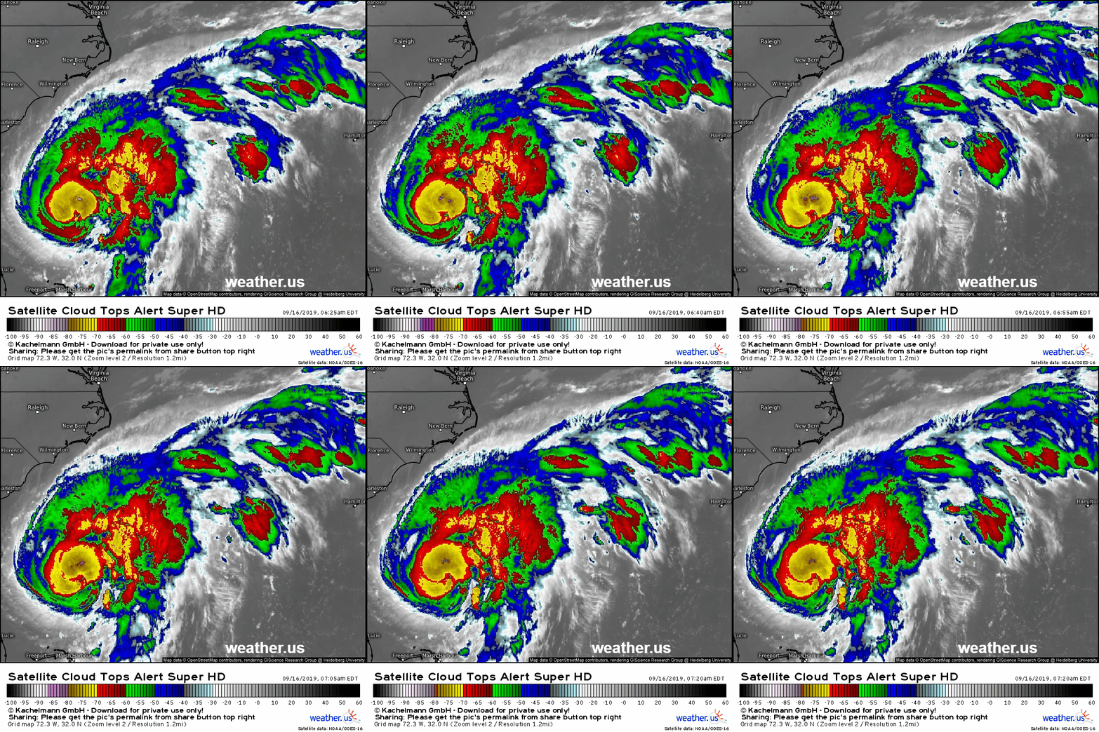
Humberto is thriving this morning, as seen by the satellite loop above. The storm has an expansive swath of cloud tops colder than -70C with a few “hot towers” or extremely intense thunderstorm cells dipping below -85C in the northern eyewall. Outflow is healthy in just about all directions and the storm will continue to be moving through a favorable environment over the next couple days. I wouldn’t be surprised to see Humberto achieve major hurricane status (Category 3, winds >=115mph) either tomorrow or Wednesday.
Here’s a look at the steering setup for Humberto on Thursday. As you can tell, it’s fairly complicated. The basic problem for forecasting Humberto’s track later this week is that we don’t know quite how fast it will be moving, nor in what direction (isn’t that helpful!). Both of these answers will be determined by how the storm interacts with a trough of low pressure splitting off from a storm currently near Newfoundland. That trough will be forced westward by an area of high pressure currently over the Central US that will be building east. Both the trough and the ridge will be trying to steer Humberto back to the west. Meanwhile, the trough farther up in the North Atlantic will be working with the subtropical ridge SE of the storm to add an easterly component to the storm’s movement. Exactly how much these two influences will cancel each other out will determine where Humberto ends up going. Map via via weathermodels.com.
With that in mind, let’s use the EPS to visualize a range of possible outcomes for Humberto.
Most of the EPS members suggest that the US ridge and the trough to the west of the system will have enough influence over Humberto to steer it north or northwest for a time later this week. However, it is very unlikely that the storm actually makes it far enough NW to hit the East Coast. Another trough swinging in from Canada will turn the storm back east this coming weekend. That said, if the storm fails to speed up later this week and that turn happens while it’s farther west, there is some chance of rain and gusty winds in Eastern NC. Again, the chance of any serious direct impacts remains low. The exception will be Bermuda which will have a close encounter with the storm Thursday or Friday. Map via weathermodels.com.
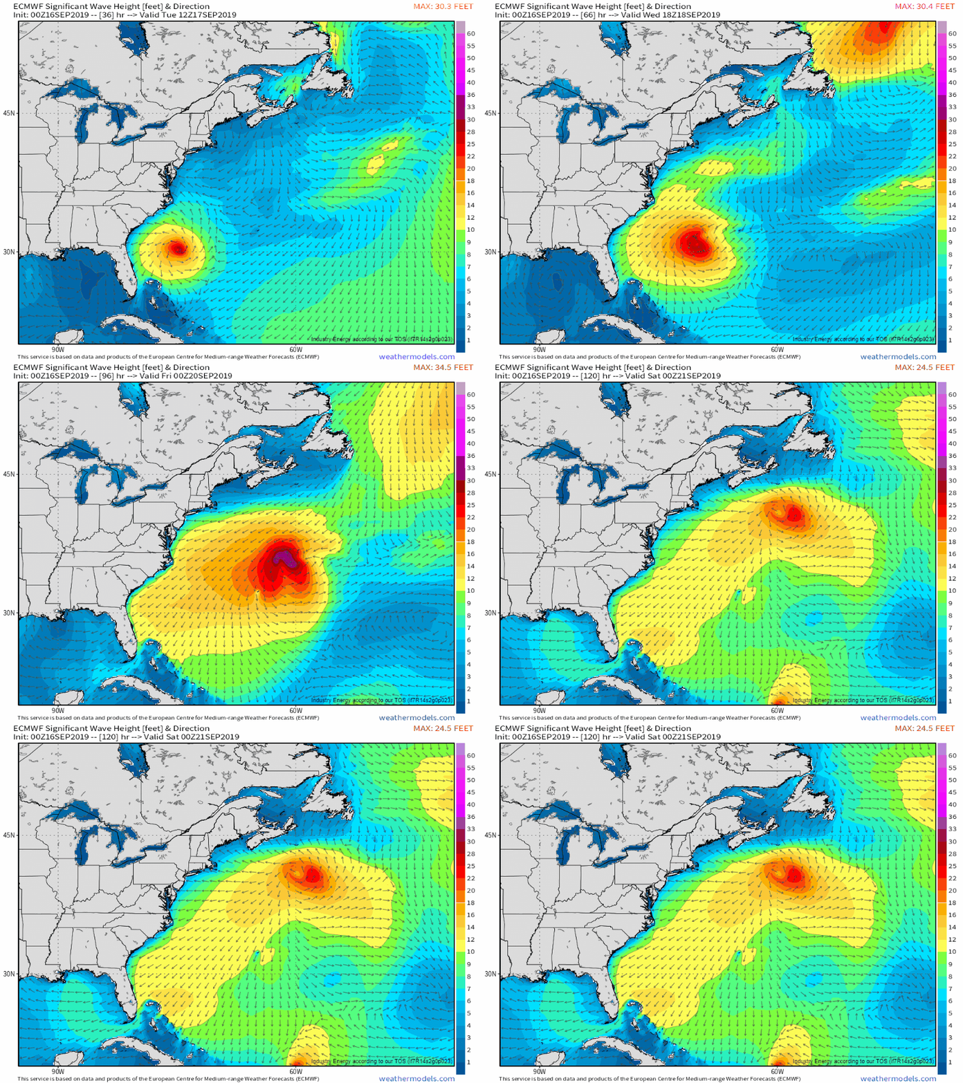
While rain and wind is unlikely to make it to the US coast, large waves from Humberto most definitely will. Powerful long-period swells from the storm will lead to very high rip current dangers from Florida all the way up into Maine this week, along with the chance for some beach erosion and minor coastal flooding. Stay out of the water unless you’re an experienced surfer, in which case have fun! GIF via weathermodels.com.
-Jack
