TS Humberto Expected To Intensify As It Moves Well East Of Florida This Weekend
Hello everyone!
The system we’ve been watching in the Bahamas over the past few days has developed into TS Humberto after closing off a center of circulation and increasing its maximum sustained winds to 40 mph. The storm is expected to gradually intensify as it moves NNW this weekend before making a sharp turn to the east on Monday. While we’ll still keep an eye out for possible shifts in track over the past few days, it looks like the storm will almost certainly remain far enough offshore that the Southeast coast won’t see much in the way of impacts. The primary goal of this post is to outline why Humberto is expected to turn to the east on Monday.
Humberto’s satellite appearance this morning is still quite lopsided with most of the shower and thunderstorm activity located to the east of the center (currently not far from Marsh Harbor, where Dorian made landfall as a Category 5 storm two weeks ago). This is due to some southwesterly shear imparted on the storm by an upper level low over the Gulf of Mexico. This shear is slowly decreasing, and the storm should be able to become more organized this weekend. You can see hints of this process on the loop above where some thunderstorm activity from the east of the center is trying to wrap around to the western side just north of Marsh Harbor.
Over the next few days, the environment is expected to become more favorable for development and the storm should steadily intensify.
Because the odds of the storm directly affecting land aside from the Bahamas today and possibly Bermuda this coming week are relatively low, I’ll focus more on the forecast track than the intensity for this update.
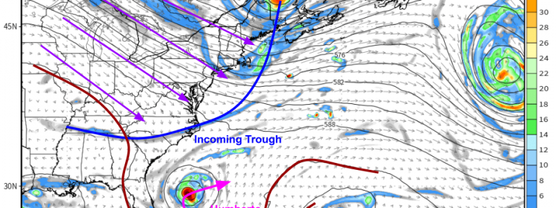
The first change to Humberto’s current NW track will come on Sunday night when a mid-level trough will break through the subtropical ridge currently steering Humberto NW. West-northwesterly flow behind that trough will turn Humberto to the east-northeast, sending it away from the Southeast coastline. There is very high confidence in this part of the forecast. Map via weathermodels.com.
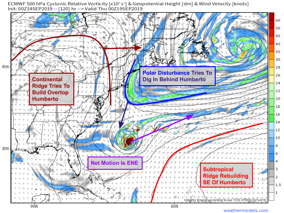
The next leg of Humberto’s journey, forecast to take place during the middle part of next week, is a little more uncertain. The storm will be moving ENE after being turned by the first trough on Sunday night. However, there will be another trough trying to dig SW behind the system Wednesday/Thursday. Meanwhile, a large continental ridge will be trying to build east into New England. As a result, winds will generally be out of the north in the mid levels during this time. Depending on exactly where the storm ends up and how strong it is, there’s some chance that another turn back to the north or northwest occurs due to the ridge building. Right now, most guidance is confident that this turn either doesn’t happen (ridge is too slow, trough grabs the storm and whisks it out to sea) or doesn’t happen enough to make a difference for the Northeast coast. That being said, the trough in question has a long way to travel down out of the Arctic Circle before arriving near the storm, and I wouldn’t be surprised if the setup shifts just enough to allow for some fringe impacts to parts of the coastline. Map via weathermodels.com.
In fact, a non-negligible number of EPS ensemble members from the latest 06z run show some sort of turn back to the N/NW later next week. At this point, there’s not nearly enough confidence in that turn to be worried if you’re in SC/NC or anywhere else in the Northeast. GIF via weathermodels.com.
I’ll keep updates on Humberto coming both here and on twitter (@WeatherdotUS and @JackSillin) over the next few days, especially if it looks like the system has a shot at impacting the coastline this week.
-Jack


