9-2-19 Major Hurricane Dorian Live Tracking Blog
Hello everyone!
This is our tracking blog for Hurricane Dorian as it moves slowly towards the Southeast US coast. This page has been updated many times over the past few days and contains observational notes on the storm as well as forecasts for those in the path. If the latest entry doesn’t discuss what you’re interested in, scroll down because if it’s impactful I’ve probably already outlined it. If you’re looking for your town’s specific forecast, you can stop scrolling here and head on over to our Forecast Ensemble tool at weather.us to see the range of possible outcomes for Dorian in your location (a tutorial video on how to use/interpret the ensemble tool can be found here).
If you’re looking for more general forecast-related discussion, please refer to this morning’s earlier post. If you have questions, send me a tweet @WeatherdotUS or @JackSillin and be sure to tune into my Periscope broadcast on the WeatherdotUS account at 7 PM EDT.
You can find the same GOES-East satellite imagery and radar imagery that I’m looking at for free at weather.us by following these links.
5:45 AM EDT 9/4/19
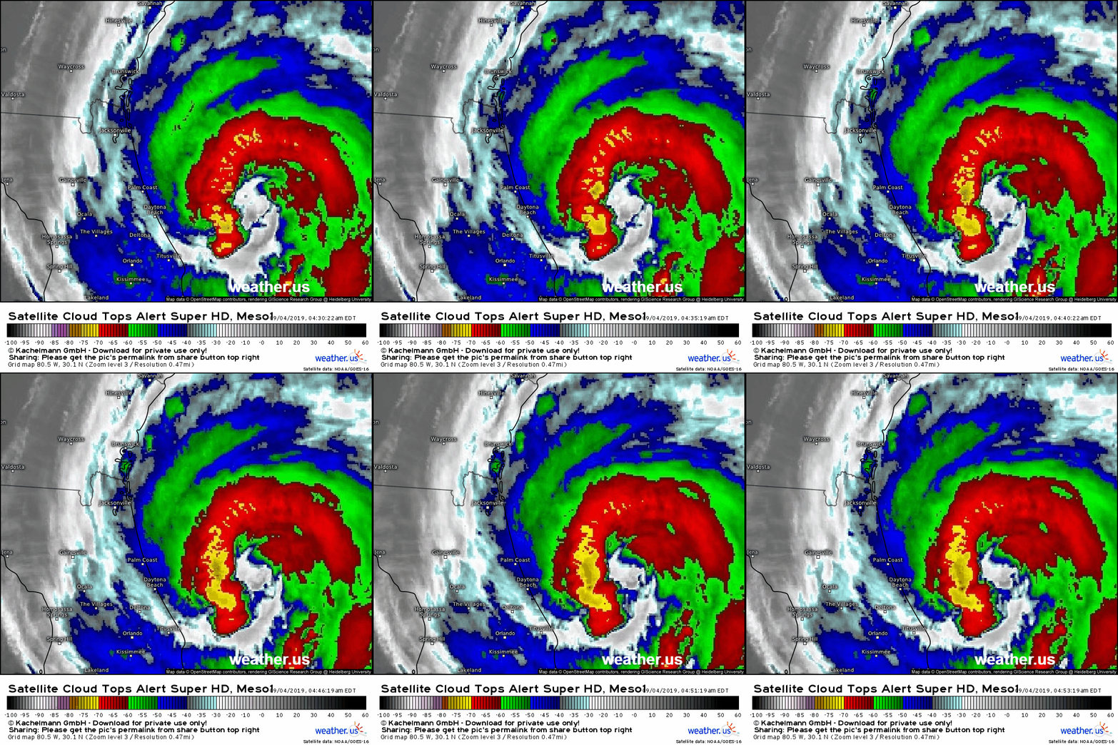
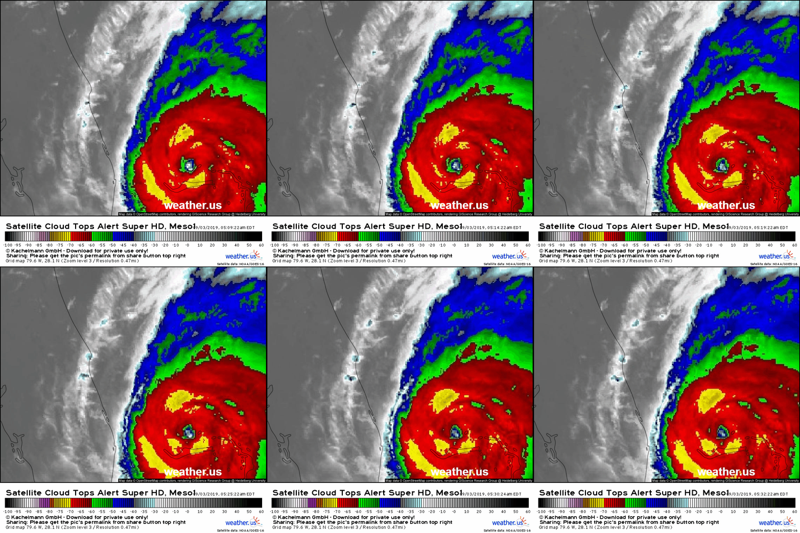
Latest GOES-East imagery this morning shows a big burst of thunderstorm activity on the western side of the system between the eye and Daytona Beach. This is a sign that the storm is trying to tap into the warm waters of the Gulf Stream and regain some of the intensity that it lost to the upwelling of recent days. The idea that this would happen has been presented in blog and periscope updates over the past few days, and the fact that we’re observing it now doesn’t change anything about the forecast for parts of the coast still in the storm’s path.
For those worried that Dorian might rapidly intensify again, let me say that it’s nearly impossible for that to happen to a very large storm such as Dorian. It takes exponentially more energy to ramp up wind speeds in the storm’s current eyewall than when it was much smaller. The reason for that is pretty intuitive: there’s a lot more mass in the storm’s inner core now than there was a week ago, which means it’s going to take a lot more force to achieve the same acceleration (Newton’s second law at work!).
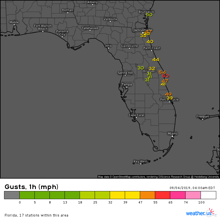
The expansion of the storm’s wind field is bringing notable impacts to Florida this morning. Despite being 85 miles from the storm’s center, Cape Canaveral is gusting to 60 mph while Jacksonville is gusting to 47 mph despite being 140 miles from the storm’s center. This has been anticipated for the past several days now, and there are no signs that the storm is expanding in a way that’s different from what we’ve been expecting.
As far as the latest forecast model guidance goes, it’s just confirming what we already have been expecting for Dorian’s forecast. Expect the current NW or NNW motion to continue through the day today before a turn to the north and northeast occurs tonight. The eye will then move NE, parallel to the coast, tomorrow while the northwestern eyewall brings hurricane force winds to the coastline. It’s basically impossible to tell whether the center of the eye will wobble onshore for an official landfall in SC, but as far as impacts go you won’t be able to tell the difference between an official landfall track and a barely offshore track.
While we were very concerned about small wobbles in track over the Bahamas and around Florida, it’s important to note that as Dorian expands, these wobbles matter less and less because the storm has a much larger target for possible tracks that would bring damaging winds onshore. Instead of needing to “thread the needle” to within 15 miles, now all the storm has to do is get somewhere within 40-50 miles and the eyewall/hurricane force winds move onshore.
What do the latest forecasts for the coast look like compared to last night? Pretty much unchanged. The odds of hurricane force winds anywhere along the coast north of Savannah Georgia continue to increase, as does the risk for damaging storm surge. The going forecast, as presented in last night’s Periscope update as well as all the blog entries you can find by scrolling down this page, remains basically unchanged. The window for making final preparations in NC will extend through today before closing tomorrow. Farther south, SC has a few more hours this morning before winds and rain increase to the point that further preparations will be difficult and/or dangerous.
Please continue consulting official NHC forecast information and heeding the advice of local officials regarding evacuations, shelters, curfews, bridge closures, use of sandbags/other resources, etc.
I will be offline most of the day today, but will have another Periscope session at 7 PM to review the latest info on the storm and answer any questions you might have.
9:00 PM EDT 9/3/19
Dorian’s large eye and disheveled overall structure continue to move north-northwest this hour. The going forecast for the Florida coast remains the exact same as presented earlier. The worst conditions are still yet to come north of Brevard County.
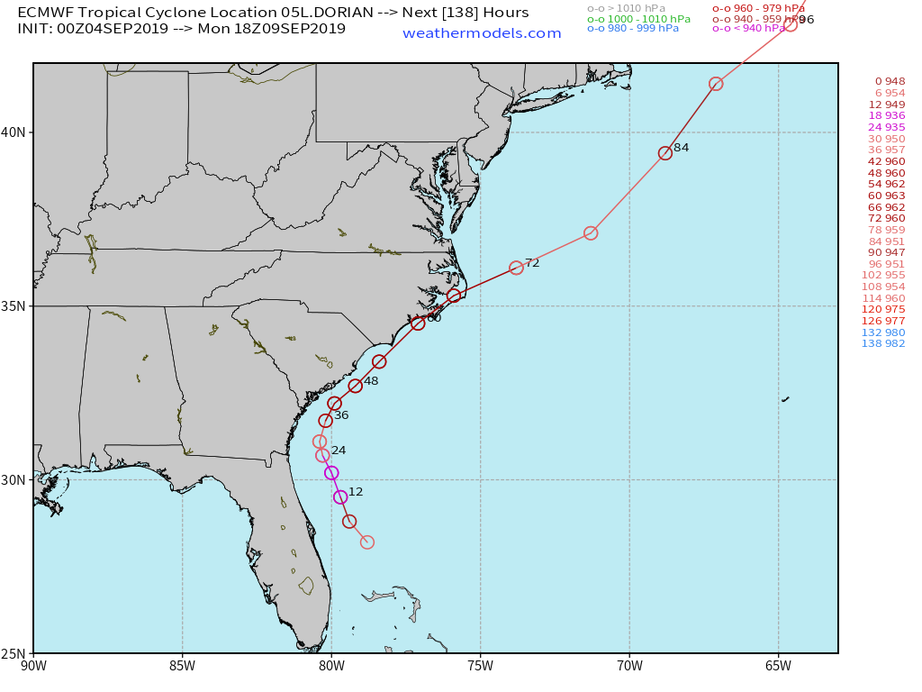
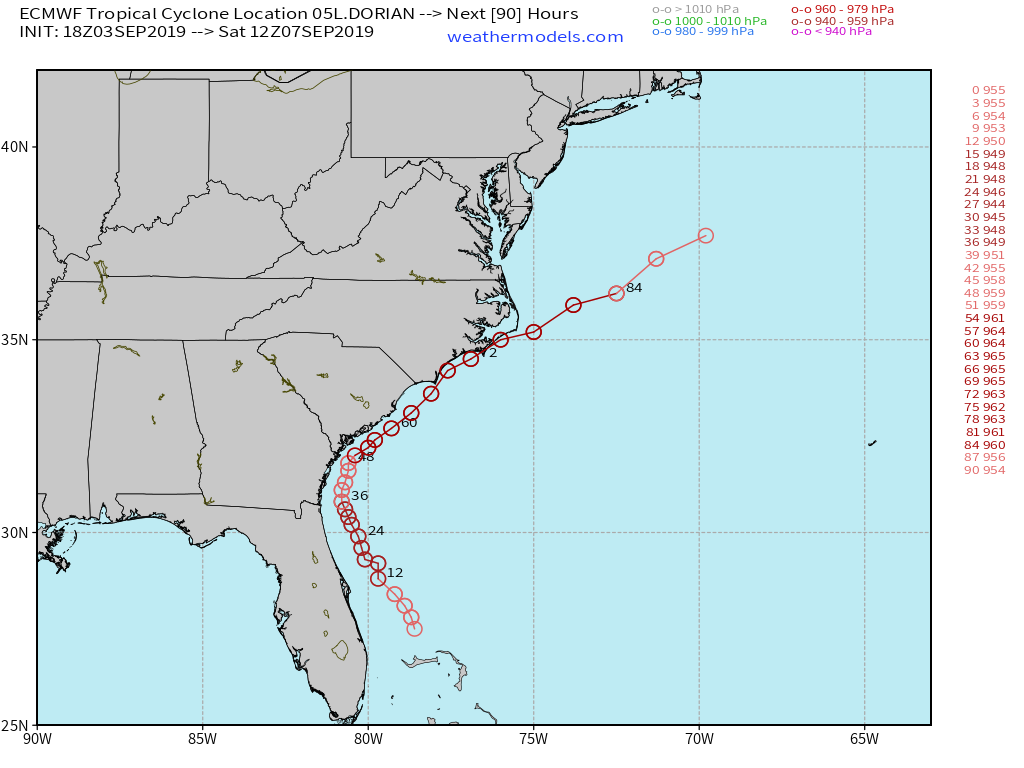
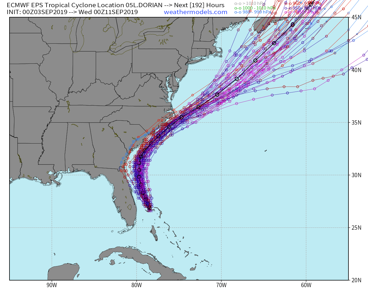
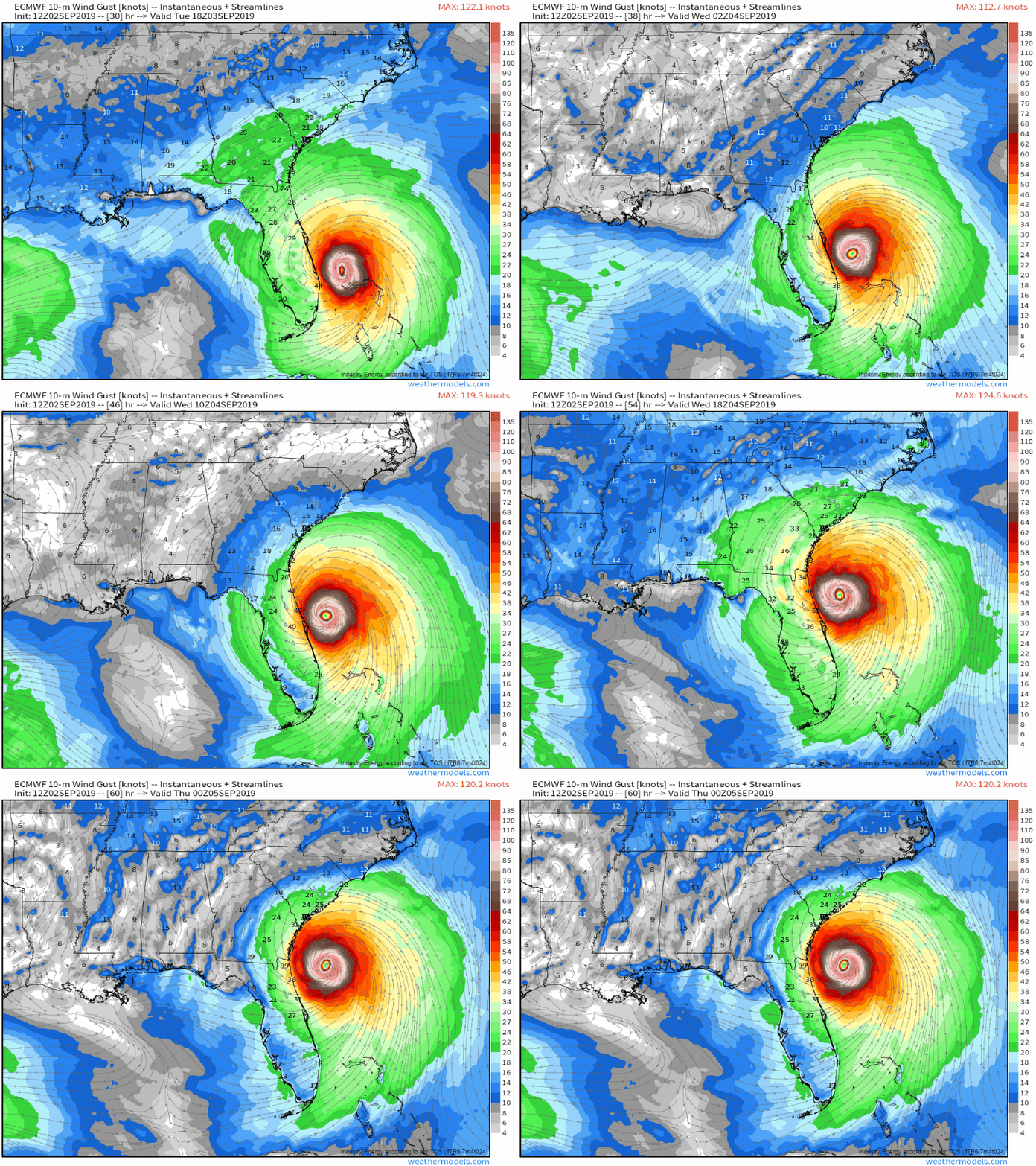
This is what the latest run of the ECMWF model shows as far as Dorian’s track goes over the next several days. It’s basically in line with the thoughts presented on the Periscope earlier (link below). If you were to really look closely, you’d see that it has nudged the track ever so slightly off to the NW especially between Georgia and South Carolina. That’s well within the range of possible outcomes outlined in the updates presented earlier this evening. If you live along the coast anywhere N of Brevard County, you need to be ready for hurricane force winds. If you live along the coast N of Savannah Georgia, you need to be ready for winds as high as 100 mph, especially if Dorian can regain some of its inner core ferocity as it passes over the Gulf Stream.
Programming Notes:
I will have another update here tomorrow morning. I will then be offline for most of the 8 AM to 5 PM EDT timeframe as alas I do still have to go to class. My next Periscope update will be tomorrow at 7 PM EDT and I will update the blog again in the evening as well.
7:00 PM EDT 9/3/19
Today’s Periscope update was done at 7 PM EDT and can be found at this link. It discusses the latest forecast for all areas impacted by the storm in light of today’s guidance and observations.
1:00 PM EDT 9/3/19
Dorian continues to feel the effects of significant cold water upwelling that has resulted from the system’s nearly stationary motion over the past 36 hours. The system is finally gaining latitude and you can tell that the center is clearly north of West Palm Beach’s latitude which corresponds roughly to the north end of Grand Bahama Island. Expect Dorian to continue on its northwestward track over the next 36 hours or so as it moves parallel to the Florida coast.
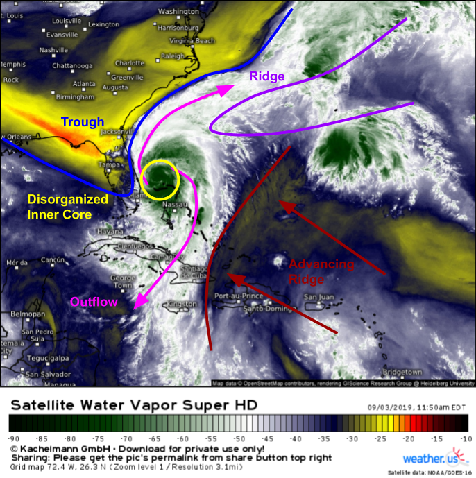
For those interested, here’s a look at WV imagery showing the current state of the features steering Dorian to the NW. A ridge of high pressure can be seen advancing towards the storm from the SE while the trough we’ve been watching so intently over the past few days drops into Florida west of the hurricane. Both features, along with the weakening of the high to the north, will continue to push Dorian NW today and tonight. As of this writing, there’s no sign of any change to the overall forecast for the storm’s impacts between Florida and North Carolina.
9:30 AM EDT 9/3/19
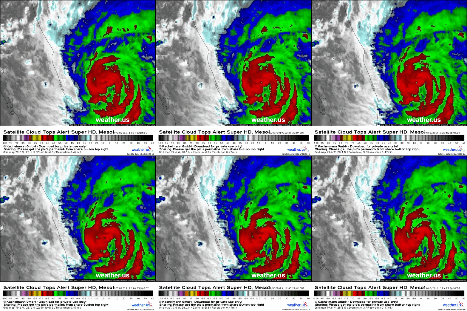
Dorian remains nearly stationary this morning just N of Grand Bahama Island. Latest satellite imagery shows that the storm’s eye has filled in with clouds, which is a sign that the cooler waters churned up by the system’s ferocious winds are limiting the amount of energy available for intense thunderstorm activity. This is good news for parts of the Bahamas still dealing with Dorian’s inner core, but it does not change the forecast for parts of the coast farther north. In fact, the current decrease in maximum wind speeds will help the overall wind field continue to expand, which means that despite the current forecast for the storm to remain off the Florida coast, the odds of strong winds making their way onshore remain high.
This loss of intensity this morning shows no signs of impacting the track forecast as the storm begins to head north, and the storm could regain some of its strength in the next 24-36 hours as it moves over warmer water.
5:45 AM EDT 9/3/19
Dorian’s satellite appearance has degraded somewhat overnight as the storm continues to churn cooler water up from below the ocean surface while it remains stationary just north of Grand Bahama Island. The eye remains well defined, but it’s not quite as warm nor as symmetric as it was when it first moved into the Bahamas. Additionally, the upper level outflow on the western side of the storm is becoming restricted as the storm begins to encounter some westerly wind shear. The storm remains completely stationary after some slow movement to the WNW yesterday. We should see the storm finally begin to move to the NW or NNW in the next few hours.
As far as the storm’s track goes, the going forecast presented over the course of several blog entries yesterday as well as on the Periscope update remains well on track. If you want all the details on why the storm is expected to track the way it is, I highly suggest reading back through this entry and those which came before it.
I will continue to update this page with new information as I see it, but I will not have enough time today to promise hourly updates. I will do another Periscope update sometime this afternoon/evening. The exact time will be announced here and on twitter @WeatherdotUS and @JackSillin before noon.
8:30 PM EDT 9/2/19
In the last hour, nothing meaningful has changed with regards to Dorian’s track, intensity, or forecast. My next update will be tomorrow morning.
7:15 PM EDT 9/2/19
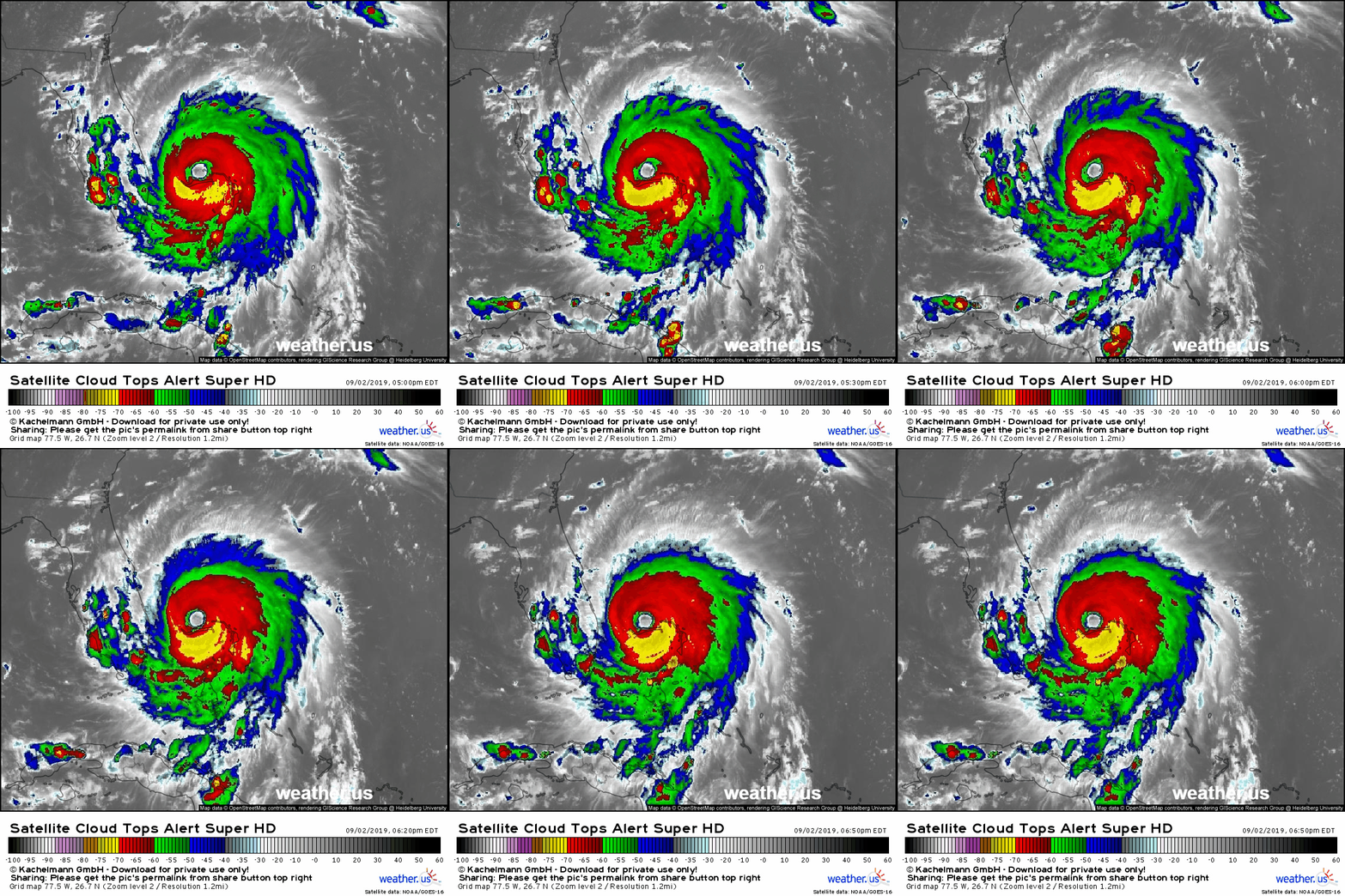
Here’s a look at Dorian on satellite imagery early this evening. After crawling WNW at 1 mph for most of the day today, the storm has officially stopped all forward motion and is considered stationary by the NHC. The satellite loop above confirms that the storm has basically ground to a halt. Its wobbling hasn’t stopped though, as you can see the storm wobble NE a bit during the first half of the loop then correct back SW during the second half. Tragically, Grand Bahama Island remains in the storm’s southern eyewall with 145+mph winds continuing to impact the island even after a full 24 hours already spent in the storm’s most intense region.
As far as updates to the track forecast go, the thoughts presented earlier in the 3 PM update and in the Periscope continue to look good. Keep in mind that the overall idea (NW movement resumes tonight, continues tomorrow parallel to FL coast, then turn NE to Cape Hatteras) remains very high confidence. Any tracking adjustments we make are a matter of 25 miles here or 30 miles there. That’s not enough to change any of your preparedness actions, it’s just a matter of trying to figure out exactly what the extent of the impact will be for the coastline. Continue to plan for the worst and hope for the best.
5:00 PM EDT 9/2/19
At 5 PM I did a live Periscope update discussing Dorian. If you missed, it, click here to watch the replay. I will do another update sometime tomorrow evening.
3:15 PM EDT 9/2/19
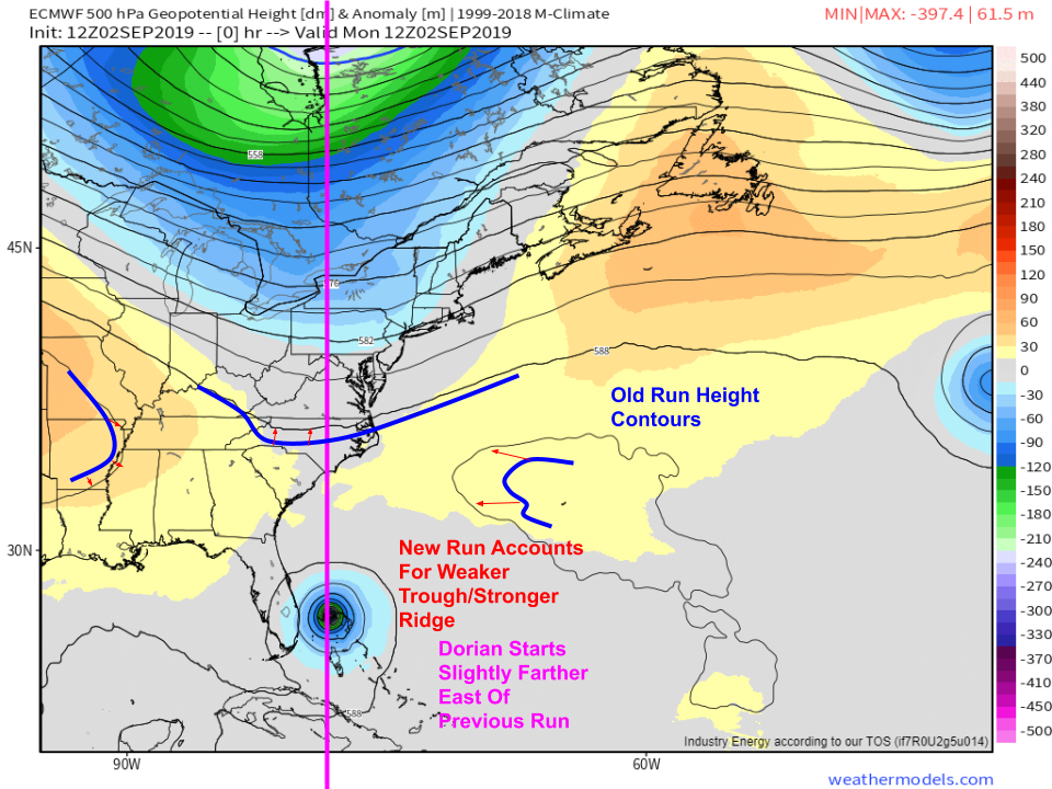
The latest ECMWF run just arrived and takes Dorian ever so slightly farther to the east vs previous forecasts. That would be good news for those along the Florida coast, but does it have any merit? This update will focus on the new model guidance and the extent to which it might be accurate.
Below is a model version of the “tracking guides” I’ve been using to watch the storm’s current movement. The pink line was drawn directly through the center of the storm where the old run had it, while the blue lines trace out various height contours of significance on the old run. By superimposing these old run snapshots on the data from the new run, we can evaluate how the forecast has changed.
The first thing to note is that the model is forecasting a stronger ridge and weaker trough in the newest run. That is consistent with observational data I’ve been presenting both here and on twitter over the past few days. However, the model also shows the storm starting out ever so slightly (20 miles at the most) farther east. That is also consistent with observations showing that the storm has spent most of the day stalled over eastern/central Grand Bahama Island as opposed to western Grand Bahama Island which was what yesterday’s ECMWF guidance was forecasting.
With that in mind, I think the ECMWF is likely onto something and Dorian might not scrape the coast quite as closely as it looked this morning/last night. It is very important to note though that this doesn’t mean there won’t be dangerous conditions in Florida. It also doesn’t mean that hurricane force winds won’t impact parts of the Florida coast. Hurricane Hunters are back out investigating the storm this afternoon, and they found that Dorian’s wind field has expanded significantly, which is exactly what we expected to happen given the Eyewall Replacement Cycle which occurred this morning.
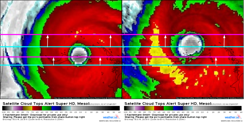
Additionally, Dorian has gained a non-negligible amount of latitude over the course of the day today. The blue lines represent the bounds of the eye (as defined earlier in this post) at 2:45 AM while the pink lines show the same eye bounds 12 hours later. Note that both the northern and southern edges of the eyewall have shifted north, though the northern edge has shifted a little bit more due to the expansion of the eye associated with the EWRC.
So what does this mean for Florida and to what extent can residents there breathe a sigh of relief?
Here’s an updated version of a map I put out earlier today looking at the range of possible track outcomes. I talked about how a slightly stronger/slightly weaker ridge would influence how sharp the turn north is. Based on observational data and the latest model guidance, it seems as though the ridge is on the stronger side, so the turn won’t be quite as dramatic as forecast earlier. However, the turn has started a little on the earlier side, which means the overall forecast track shifts slightly east (by 20-30 miles). I’ve drawn an updated track forecast line on the graph above by copying what I had outlined as the stronger ridge option and setting its initial position to be where Dorian is now to illustrate the effect on the downstream forecast.
Here’s the ECMWF’s latest wind forecast from tomorrow afternoon through Wednesday evening as Dorian moves up the Florida coast. Roughly speaking, hurricane force winds begin with the dark red shadings (>64kts). You’ll see that parts of the Space Coast are still expected to see hurricane force winds despite the slight shift in track and that the storm will be wobbling considerably as it moves up the coast. If it were to wobble enough to the west, parts of the barrier islands could sample the storm’s western eyewall with winds over 100 mph. Additionally, though the odds of hurricane force winds have decreased somewhat in places like West Palm beach, Dorian will still be a dangerous storm with heavy rain, storm surge flooding, and large battering waves able to cause problems even well away from the storm’s center.
While residents of coastal Florida have reason to be hopeful that Dorian may not be quite as devastating as it could, and still might, be, today’s trends do not suggest that the state is out of the woods, that residents of barrier islands shouldn’t evacuate if told to, or that Dorian is not a dangerous storm worth taking very seriously.
A similar message applies to Georgia. If you’re reading from North or South Carolina, know that your level of impacts will depend largely on Dorian’s next turn, to the northeast, which still may occur faster or slower than forecast. A landfall in North Carolina remains a distinct possibility even if the odds of landfall in Florida have dropped.
1:45 PM EDT 9/2/19
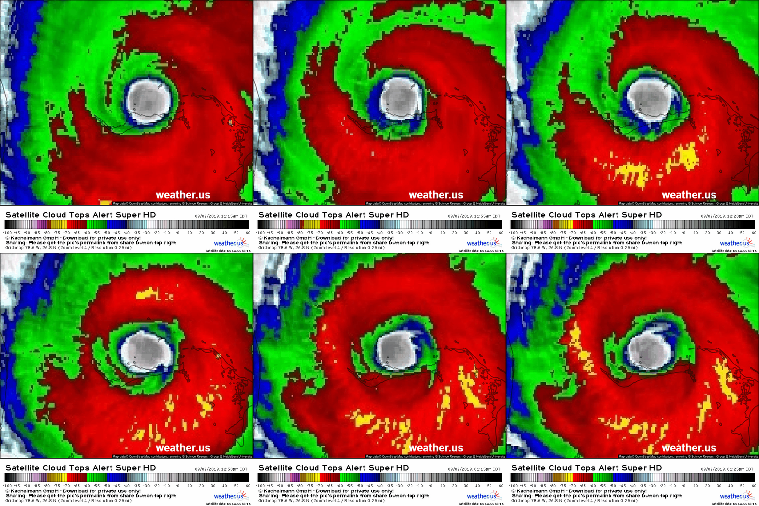
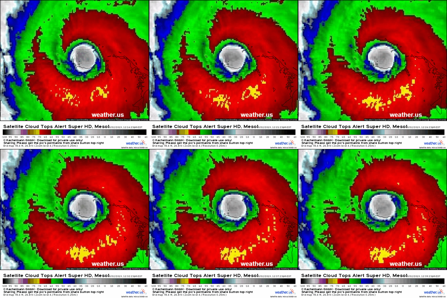
I chose a slightly longer satellite loop (at 5-min temporal resolution) for this update because it does a great job showing an important trend that has been in progress over the past 1-2 hours which is the completion of the Eyewall Replacement Cycle we observed earlier this morning. Note that the cloud top temperatures in the eyewall have cooled from -55/-60 to -60/-70 especially in the NW quadrant of the storm. Additionally, the eyewall is beginning to tighten up again as shown by the increase in convection over the southern part of the eyewall. Consequently, if I were to draw the same tracking plots that I did earlier, it would look like the storm has gained more latitude than it really has because the development of cold cloud tops over Grand Bahama Island has much more to do with recent convective development in the eyewall than a sustained tracking pattern. Since the last update, the storm has moved a mile or two west and a half a mile to a mile north, so it remains on track.
Observational data over the past hour gives no reason to alter the going forecast for track or impacts.
12:45 PM EDT 9/2/19
Here’s the latest satellite loop of Dorian as it drifts slowly WNW near Grand Bahama Island. Not much has changed in the past hour, we’ve picked up several miles of westward motion (note the small islands previously in the storm’s western eyewall are now in the eye. The storm has also picked up a tiny bit of latitude, with the small island previously in the northern eyewall now in the NE corner of the eye. Overall this is consistent with forecast expectations and I currently see no reason to change the going forecast of a track very near the Florida coast before turning NE towards North Carolina.
11:45 AM EDT 9/2/19
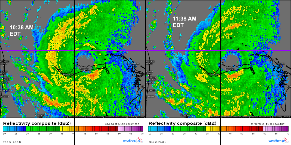
Over the last hour, Dorian hasn’t changed much. An updated look at radar imagery with a similar tracking approach to that which I used below shows hardly any movement of the storm’s eye. One trend of note has been the slightly lower reflectivity values found across the storm. This is consistent with satellite imagery showing warming cloud tops in the storm’s eyewall and adjacent banding regions. These trends point to either the effects of the EWRC that the storm recently completed, or some upwelling of cooler waters from deeper in the ocean. Either way, it’s not particularly significant as intense storms often undergo minor fluctuations in intensity. Dorian remains an extremely dangerous storm for the coasts of Florida, Georgia, South Carolina, and North Carolina.
10:45 AM EDT 9/2/19
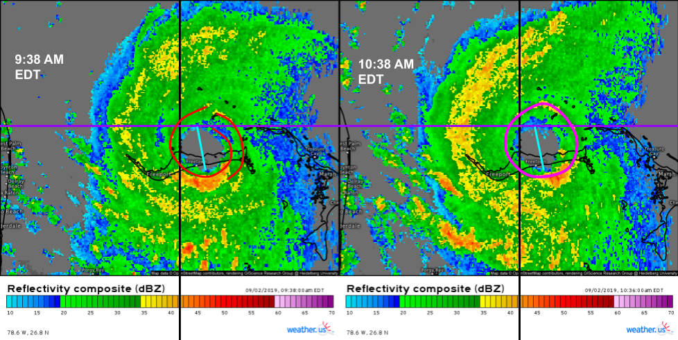
Here’s a look at how the storm has evolved over the last hour via long-range radar imagery out of Miami. I set up tracking guide lines where the northern and western edges of the eye were at 9:38 so you can compare with the 10:38 imagery. You’ll see there was around a mile of gain westward and perhaps amount the same northward. I also included a blue line which measures the diameter of the eye last hour. You’ll notice the eye has expanded a bit over this timeframe. This is consistent with the idea that the storm is working on completing an eyewall replacement cycle this morning. You can see the remnants of the concentric eyewall structure on the 9:38 image with a marked shift towards a unified eyewall in the later imagery. Based on that, I don’t think the slight gain in latitude is very meaningful when it comes to long-term tracking. Remember, the sustained turn isn’t expected to begin until tonight.
9:45 AM EDT 9/2/19
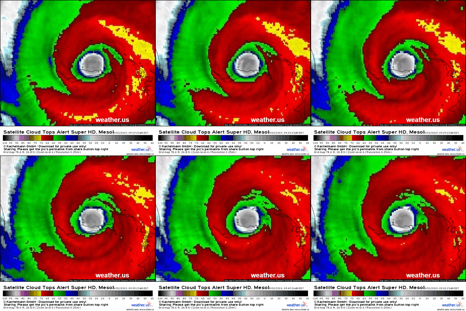
Here’s the latest GOES-East 1-min satellite animation ending at 9:42 AM EDT. Dorian’s eye is clearly visible over the east-central part of Grand Bahama Island. If you look closely enough, you’ll see the eye wobble ever so slightly to the south. Does that mean anything?
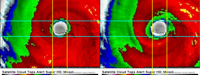
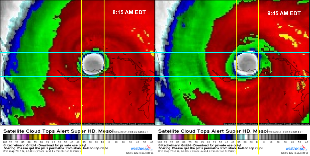
To evaluate whether an observed movement on satellite imagery is a wobble or a trend, we need to see how long it persists for. My benchmark is in the 1-2 hour range. If it lasts for under an hour, probably a wobble. If it persists for over 2 hours, it’s probably a more meaningful trend (though not always). To see if we have something of note here, let’s compare the position of the storm at 8:15 AM vs 9:45 AM.
Each yellow line represents a longitudinal bound on the eye at 8:15, which I’ve arbitrarily set to be areas where cloud top temperatures are higher than -40C. This means we won’t get too caught up in how the eyewall convection is waxing or waning as the storm’s eyewall replacement cycle gets underway. The blue lines are latitudinal bounds of the same -40C mark, also at 8:15. Both images are the exact same size and centered at the exact same place, and I’ve copied the blue and yellow lines to be in the exact same place on both images. Now, we can look at the 9:45 image to see where the eye has moved. The answer? Any movement would be very slightly to the west. This is consistent with NHC advisory information as well as the going forecast, and we can conclude that the long-awaited turn to the north has not begun yet. Does that mean anything for the forecast? No, because the turn isn’t forecast to happen until later tonight.




You have a great product in your writing….CNN/FOX/NBC don’t even come close to the great detail you describe.
Wow, the in depth info you provide is awesome. Makes understanding the complex tracking of these storms. So much more info as opposed to the networks. Thank you.