Category Five Dorian Stalls Over Grand Bahama Island, Will Begin Impacting Florida Tonight
Hello everyone!
Dorian remains an extremely intense hurricane this morning with 165 mph sustained winds and higher gusts. The storm has nearly come to a stop over Grand Bahama Island with the official NHC advisory setting the initial forward motion to 1 mph as of 5 AM. The most immediate concern from the storm is of course Grand Bahama Island where winds over 150 mph have been in progress for many hours already, and will continue for many hours to come. It’s hard to imagine just how intense conditions are on that island this morning. As we move into tonight, the storm will wobble ever so slowly to the north of the island before making its way towards the Florida Coast tomorrow.
This post will outline the updated forecast for the storm from now until it exits the Outer Banks of North Carolina on Friday night. As a quick note, I will be doing another Periscope event today at 5 PM EDT to discuss the storm, its forecast, and answer any of your questions.
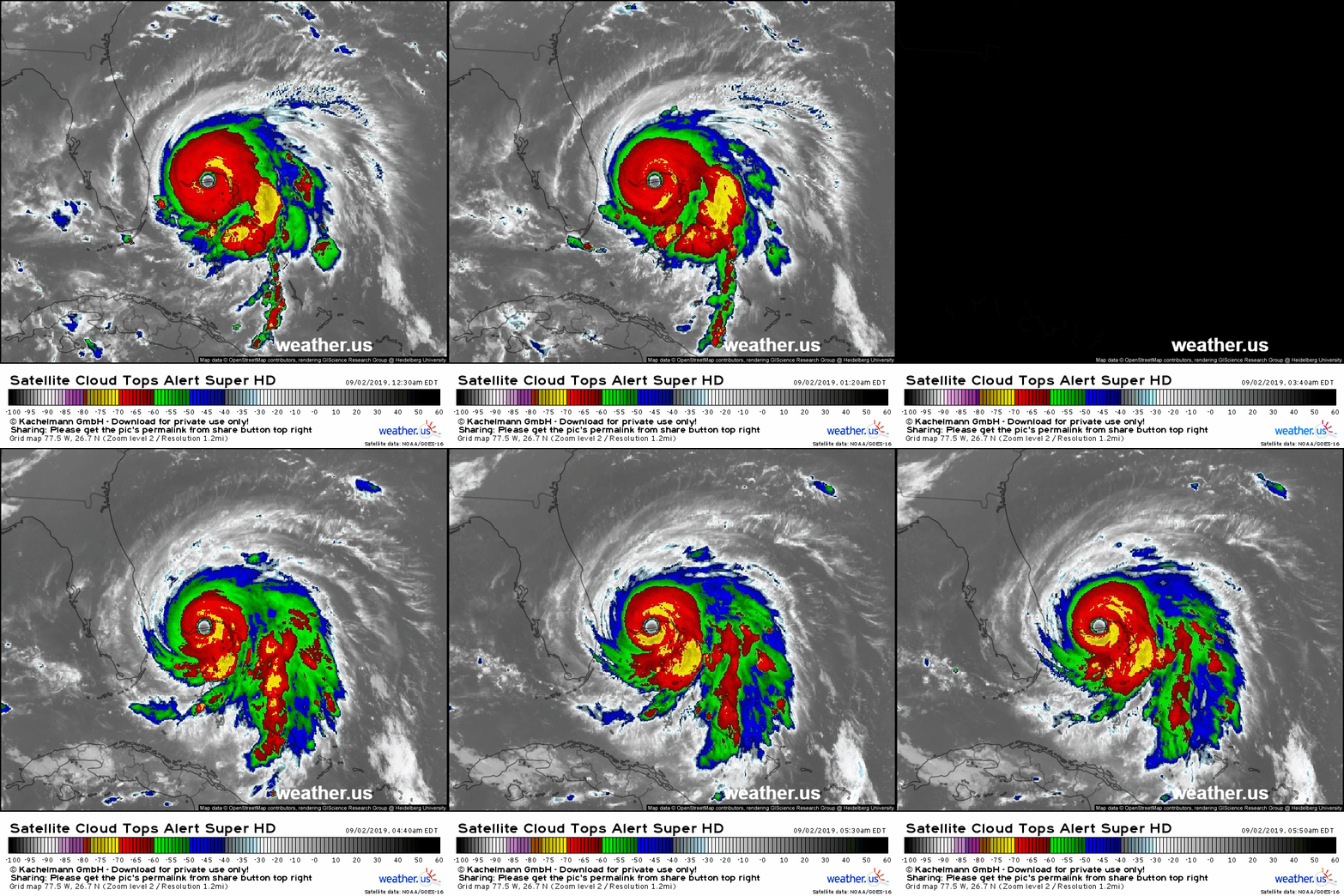
Here’s a loop of satellite imagery showing Dorian over the last 6 hours. Note that the storm has barely moved during this time, consistent with forecast expectations that it would stall right near Grand Bahama Island. The storm remains extremely healthy and powerful by just about any metric. The storms in the eyewall continue to produce very cold cloud tops, upper level outflow continues to race away from the storm in all directions, and the eye remains very warm and well defined.
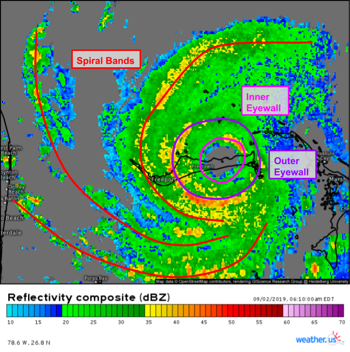
Speaking of eyewalls, radar imagery from Miami shows that Dorian will be undergoing an Eyewall Replacement Cycle (EWRC) at some point either today or tomorrow.
An EWRC happens when the configuration of storms in the eyewall (the innermost part of the storm right next to the eye) becomes unstable. At this point, a new eyewall with a larger diameter will form around the old eyewall, which will collapse. This process can be seen on the radar image above where there are two concentric circles of higher reflectivity values, indicating strong thunderstorm activity organized in two eyewalls. This cycle is somewhat analogous to an oil change for hurricanes. It’s routine maintenance important to keep them running in good shape, but the actual process of swapping the old for the new will slow things down for a few minutes. As a result, we can expect Dorian’s maximum winds to decrease slightly over the next 24-48 hours as its inner core reshuffles a bit.
The decrease in maximum wind speeds is of course good for those in the path of the eyewall (though the “weaker” 150 mph winds are still nothing to sneeze at), but there’s a side-effect of this whole process that can be very dangerous. As the winds at the very center of the storm slow down, the momentum gets spread around to a wider area. This means that the wind field expands in size, and it will be easier for strong winds to impact the coast even if the center remains a little farther offshore.
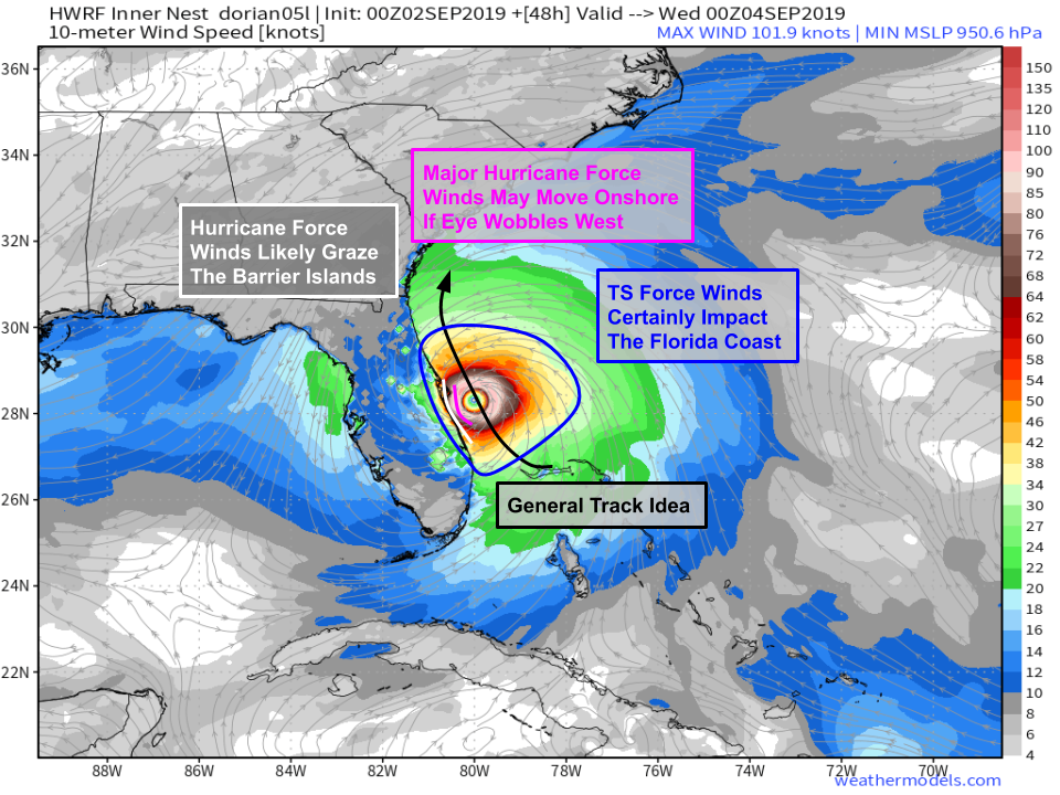
Here’s a look at how that impacts the Florida wind forecast. The storm’s center is very likely to track just offshore. That’s farther east than the forecast from back on Wednesday/Thursday, and a bit farther west than the forecast from back on Friday/Saturday. The storm’s center will likely pass between 25 and 50 miles off the coast, give or take. When the storm made landfall in the Bahamas yesterday, hurricane force winds extended only 25 miles to the west of the storm’s center. If the storm were to remain that exact size, Florida wouldn’t see hurricane force winds based on the current track forecast. However, the radius of hurricane force winds will grow as a result of the EWRC. The exact extent of that growth is still hard to tell, but any increase from the current size would bring hurricane force winds onshore even if the eyewall remained offshore. Map via weathermodels.com.
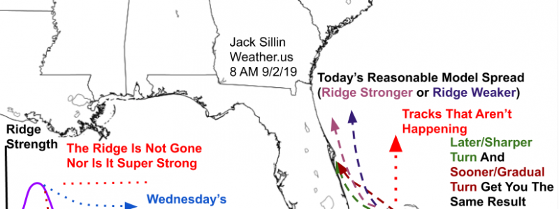
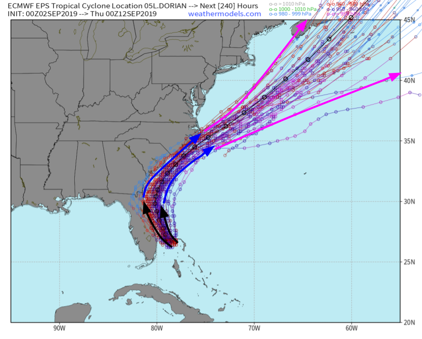
Speaking of Dorian’s exact track along the Florida coast, here’s a look at a schematic perspective of the range of possible outcomes as of this morning and how the ridge affects the track.
Many people seem to think that the west turn might not happen, or that my posts showing the ridge to be stronger than forecast over NC this morning will prevent the north turn from happening. That’s not true, the north turn will happen, it’s just a matter of extent. When I say “the ridge appears to be stronger than the models are showing,” that doesn’t mean it’s strong enough to block the turn, it just means that it’s a little stronger than the model forecasts, so I’d lean a little closer to the coast (see the pink vs dark purple arrows on the map above) than the model guidance suggests. Note that this doesn’t mean I think the storm will make landfall in Florida. That will depend on small-scale wobbles like the ones going on in the Bahamas currently.
Once the storm gets passed Florida, it will turn to the northeast in response to another upper level trough moving through the Great Lakes. This will bring the storm quite close to the coasts of GA, SC, and NC between Wednesday and Friday. Right now, the best chance of landfall is near Cape Fear in North Carolina on Friday. That being said, dangerous winds, flooding rains, and storm surge are possible anywhere between West Palm Beach Florida and Norfolk Virginia. The exact extent of those impacts (3 vs 8 feet of surge, 5 vs 15″ of rain, 50mph vs 80 mph winds etc.) will depend on exactly how close Dorian gets to your part of the coast. Unfortunately, that’s just not something we know the exact answer to at the moment. Map via weathermodels.com.
I will be doing another Periscope live event on the @WeatherdotUS account at 5 PM EDT to discuss the latest info on the storm and answer your questions.
If you haven’t already, give us a follow on twitter @WeatherdotUS and @JackSillin for more storm-related updates through the next few days. My next post here will likely be this time tomorrow morning.
-Jack



Jack never sleeps ! dude, get some snooze time in as lil’ miss dorian makes a stop in the bahamas! you’ve earned it, and we’re grateful for your diligent reporting !