Category Four Hurricane Dorian Bearing Down On The Bahamas This Morning, Southeast US Impacts Begin Tomorrow
Hello everyone!
Dorian remains an extremely dangerous Category 4 hurricane this morning as it approaches Grand Abaco Island in the Northwest Bahamas. The storm has maintained 150 mph sustained winds overnight, and could undergo some additional intensification over the next couple days. This post will outline the updated forecast for the storm between now and when it exits into the open ocean east of North Carolina on Friday.
You’ll notice if you read this post that I’m making some adjustments to model data based on my own analysis of where I think Dorian will track. I dug into my reasoning behind this adjustment in a separate post this morning, which I invite you to read if you’re curious to learn more about how storms like this are forecast.
Finally, remember that the thoughts here are mine alone and in no way are a substitute for official National Hurricane Center information. If you’re in Dorian’s path and in need of forecast info to make crucial decisions, the NHC and local officials are the place to go.
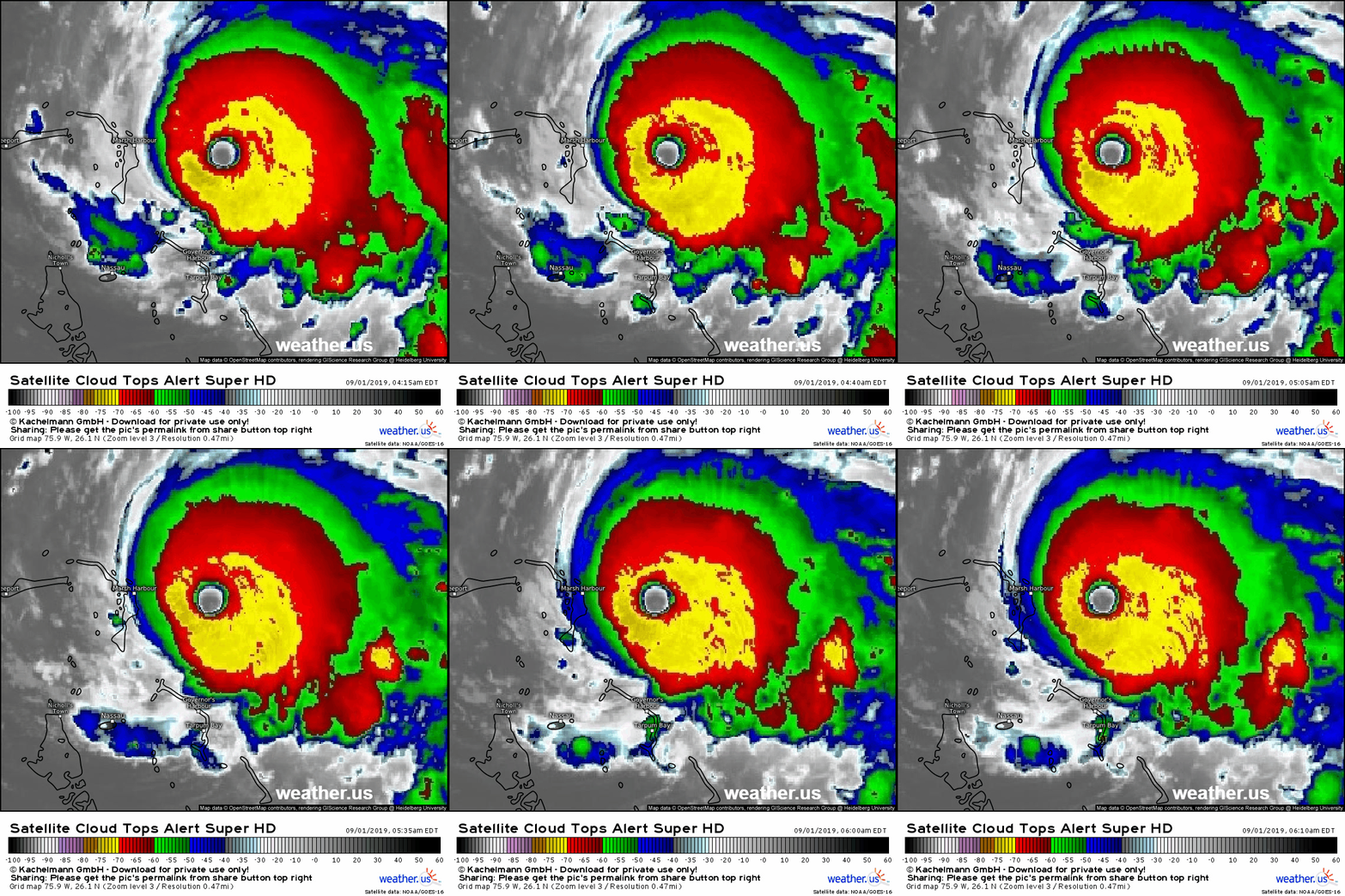
Here’s a look at the storm via satellite imagery this morning. The warm and well defined eye is clearly visible east of Marsh Harbour on Grand Abaco Island in the Bahamas. The eye is surrounded by a fairly symmetric ring of intense thunderstorms with cloud tops temperatures between -70 and -75C and if I were to zoom the loop out a bit more you’d see expansive upper level outflow especially to the east of the storm. I chose 5-minute imagery to embed here, but I highly recommend you check out the 30-second imagery of Dorian especially once the sun comes up. It’s amazing to be able to see each and every cloud in a tropical cyclone move at that temporal resolution, and it’s a great illustration of our atmosphere’s fluidity. You can make the satellite loops longer by pressing the “clock +” icon near the bottom left of the satellite map where you’ll also find a slider to adjust the animation speed.
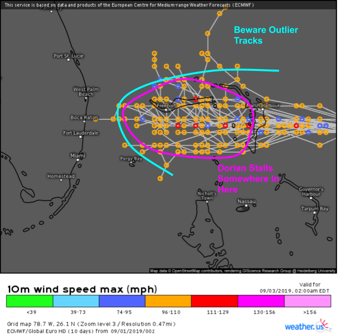
The most imminent concern regarding Dorian is its impact to the islands of the Northwest Bahamas. The storm will make landfall on Great Abaco island sometime this afternoon before moving west into the waters between Great Abaco and Grand Bahama. The storm will be moving very slowly at this point (<5 mph) meaning that these islands will experience hurricane force winds, torrential rain, and storm surge flooding for a prolonged time. If you live in these islands, the time for preparation is nearly over.
As the storm stalls out, its eyewall will remain stuck over the same places for a prolonged time. For example, the ECMWF model (shown here) predicts winds in excess of 100 mph for nearly 48 hours in Freeport, the second largest city in the Bahamas located at the west end of Grand Bahama Island. Please keep these islands in your thoughts and/or prayers over the next few days. GIF via weathermodels.com.
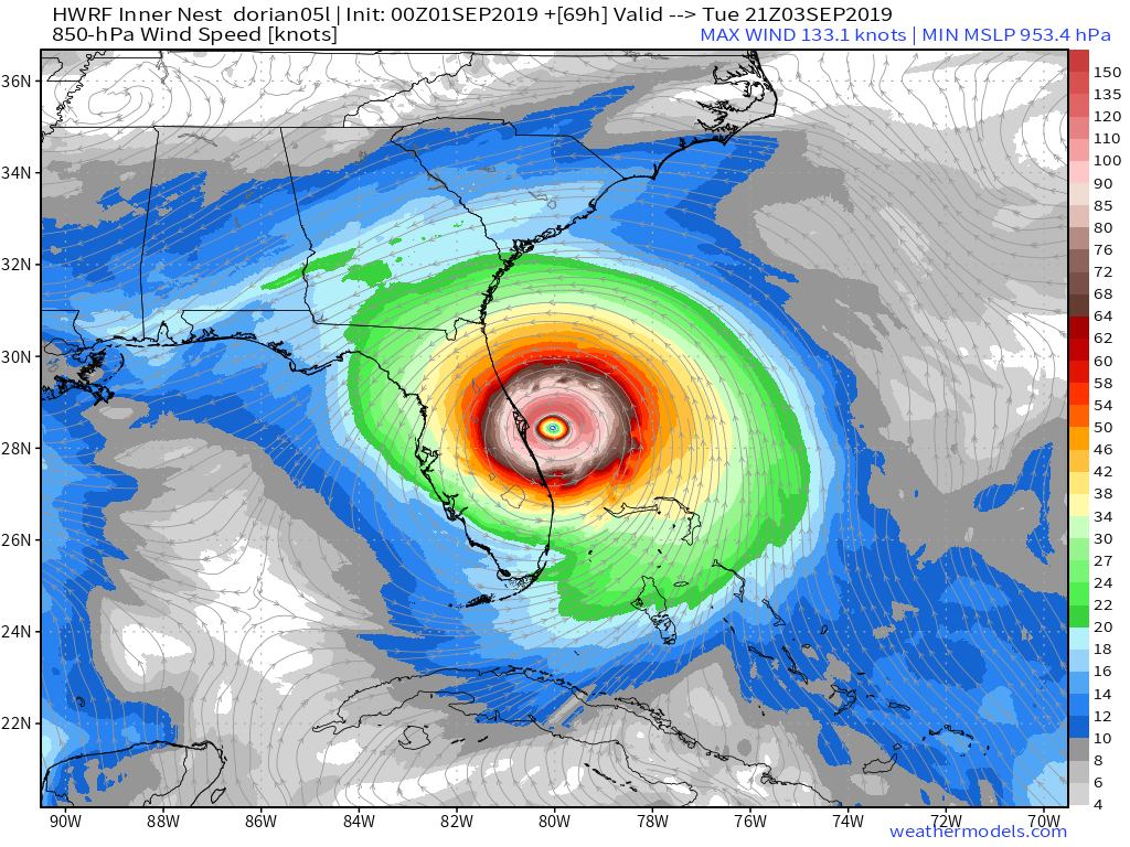
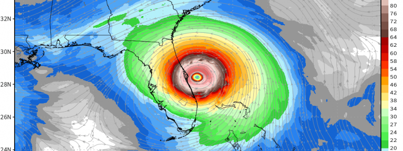
By Tuesday, all eyes will turn to Florida as Dorian begins turning north and follows the state’s east coast towards Georgia. The HWRF model shown above (note that this is the forecast for winds at 5,000 feet, not the surface) continues to support the idea that the storm will track very close to the coast, close enough that some areas likely experience the eyewall if not the eye itself. Residents of Florida’s East Coast have today and tomorrow to wrap up preparations for Dorian’s arrival. Map via weathermodels.com.
If you’re wondering where I think the system is headed, here’s my answer based on a detailed analysis of model data and upper air observations last night. I strongly believe the storm will follow a course through the western side of the guidance envelope (spread in spaghetti models shown here) before turning northeast towards NC. Whether or not the center actually makes landfall is another question, the answer to which will be determined by very small scale wobbles in track that are impossible to predict 3 hours let alone 3 days before they happen. Map via weathermodels.com.
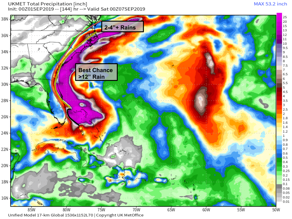
Here’s a look at how much rain Dorian could produce over parts of the Southeast. The variety of colors in the data make it somewhat hard to draw clearly visible lines, but I’ve done my best to highlight where the best chance of extremely heavy rain (12″+) is likely from the NE Florida coast through coastal parts of SC/NC and where impactful but not extreme rainfall (2-6″) is expected from parts of Eastern Florida just away from the coastline through coastal GA and southeastern SC into eastern NC). The exact rainfall observed will of course depend on the storm’s exact track. The bottom line is that if you live along the coast of Florida (north of West Palm Beach), Georgia, South Carolina, or North Carolina, you need to be ready for both a lot of wind and a lot of water. Map via weathermodels.com.
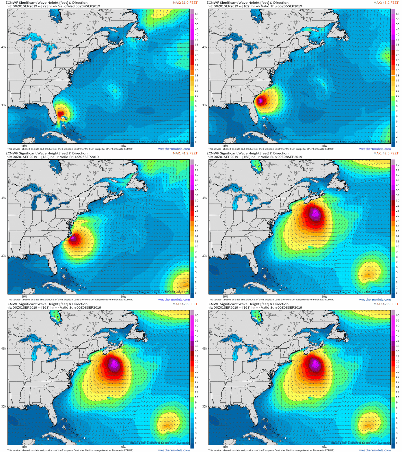
In addition to the freshwater flooding threat, Dorian will be moving plenty of ocean water towards the coast as it moves north. This will come both in the form of storm surge (not shown) and high surf (shown in the loop above). Depending on the exact track, the surge could push water levels several feet above normal high tide marks. 20-30 foot waves will add to the concern, resulting in considerable beach erosion all the way up the East Coast, even for areas unlikely to see a drop of rain from the storm. GIF via weathermodels.com.
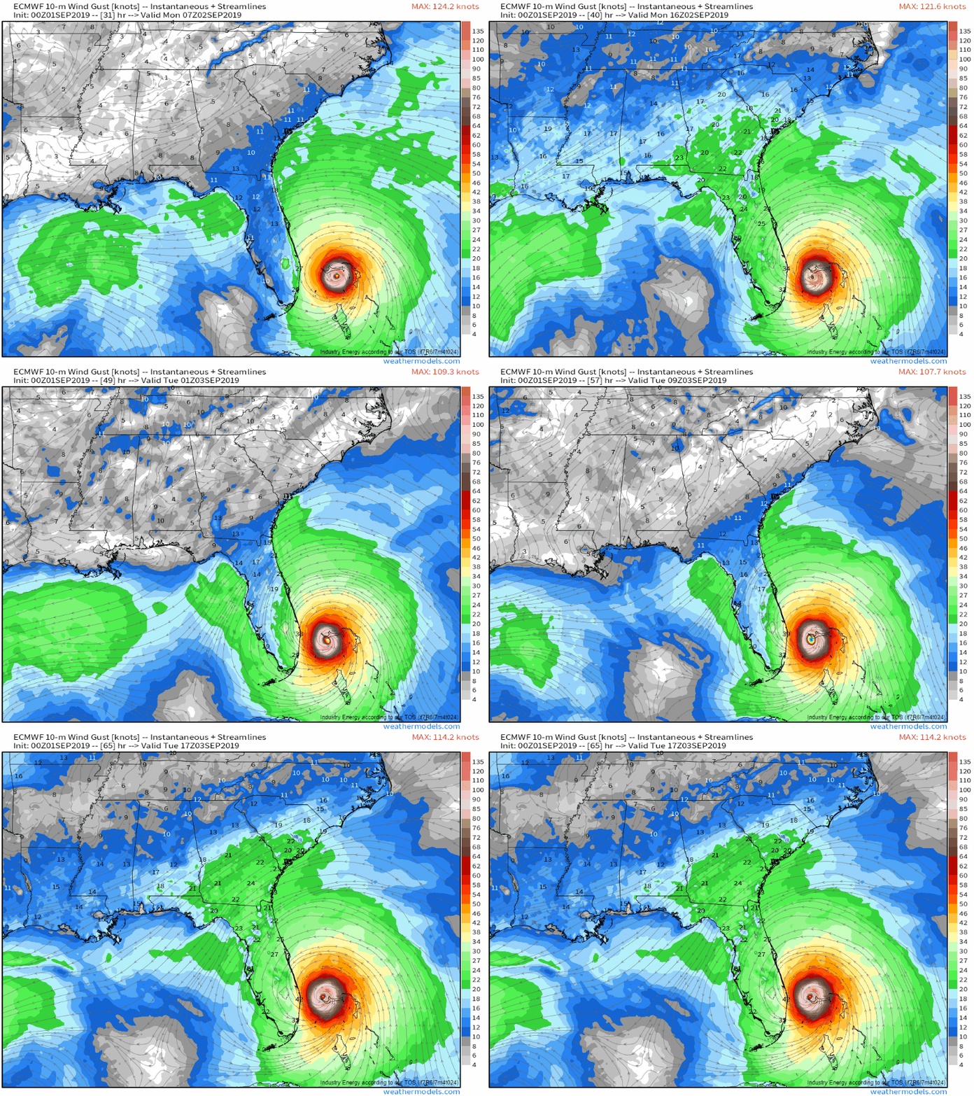
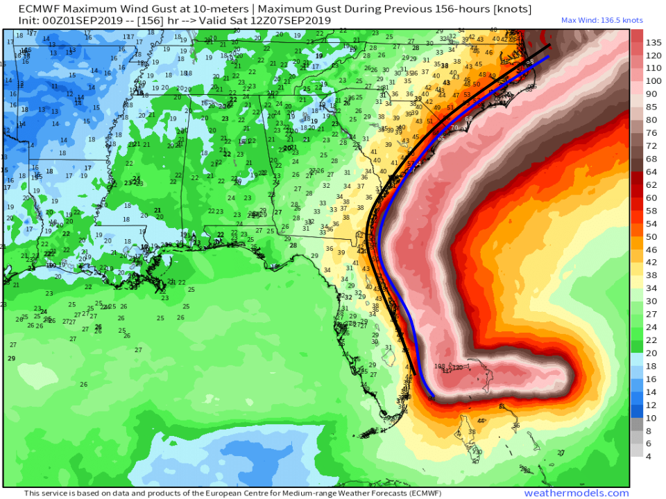
As far as winds go, the ECMWF does a decent job highlighting the swath of max winds, but keeps it too far offshore based on where the center of Dorian is likely to track. I’ve marked the model’s forecast for the western extent of hurricane force winds in blue and my rough forecast in black. Note that the difference is only 30-40 miles at most, but it only takes that small shift to make a big difference. Map via weathermodels.com.
I’ll have more updates throughout the day today on twitter @WeatherdotUS and @JackSillin. I will also be doing a Periscope from the @WeatherdotUS account at 5 PM EDT today to discuss updates to the forecast and answer any questions you may have.
In the meantime, follow along with the storm’s progress via GOES-East imagery, check the latest forecasts for the range of possible outcomes in your town via our Forecast Ensemble tool, and make sure you stay up to date with the latest official info from the NHC.
-Jack
