Checking In On The Tropics
Hello everyone!
With August now nearly half over, we’re approaching the time of year where tropical activity is expected to pick up. With that in mind, I thought it would be good to take a quick look at the state of the Tropical Atlantic to see what we might be able to expect in terms of tropical trouble (or the lack thereof) during the next few weeks.
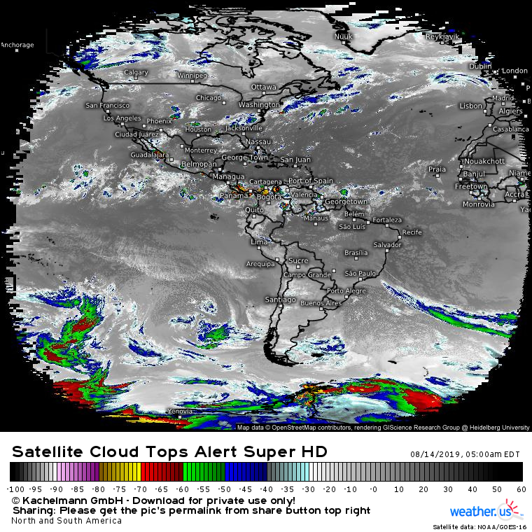
Here’s a look at this morning’s satellite picture of the Western Hemisphere, and it doesn’t take an expert to figure out that there isn’t much happening in the Tropical Atlantic. The information displayed here is the temperature of the cloud tops in a given area, with colder values corresponding to taller clouds. In the tropics, taller clouds mean bigger thunderstorms, which are the building blocks of tropical cyclones. Currently the coldest cloud top visible in the Tropical Atlantic is about -55C which suggests a weak thunderstorm.
So what’s behind the lack of activity? There are two main factors: dry air and large scale sinking air.
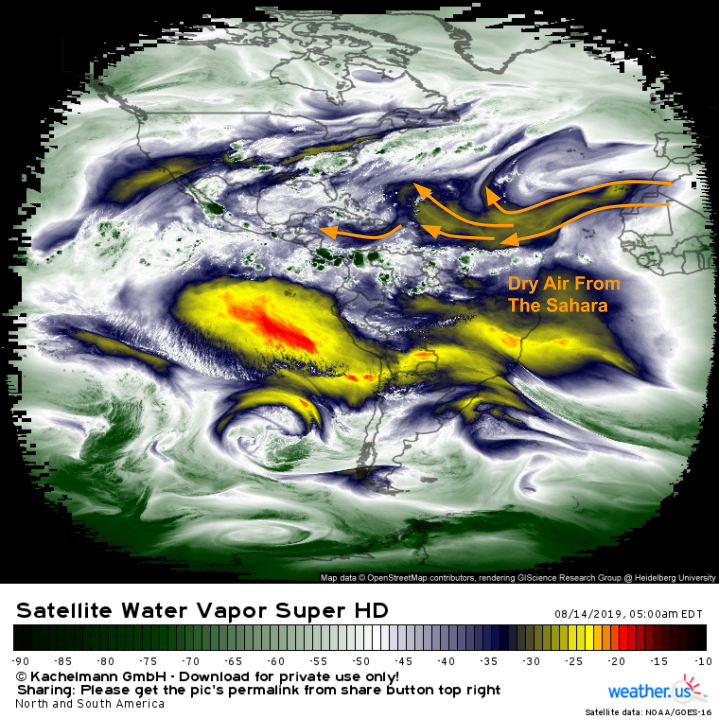
The dry air is easiest to see with a quick check of GOES-East WV imagery. A plume of dry air spreading west from the Saharan Desert is clearly visible across much of the Tropical Atlantic. This dry air gets ingested by thunderstorm clusters associated with tropical waves moving off the African continent. Some of the water droplets produced by the thunderstorms then evaporate into the drier air, resulting in a drop in temperature which makes the air heavier (remember cold air is denser than warm air). That heavy air then sinks towards the ground, as heavy things do, killing off the updraft in the process. To persist long enough to develop into a tropical cyclone, tropical waves need to be in a relatively moist environment, an environment currently elusive in the Tropical Atlantic.
Here’s a look at the ECMWF’s forecast for 500mb relative humidity which is a good proxy for the type of dry air (mid-level) that’s most impactful to tropical cyclones. At the beginning of the loop, the expansive area of dry air we outlined in the WV image above is clearly visible. By the end of the loop, the coverage of the dry air has diminished somewhat, especially in the far SE corner of the basin where the tropical waves would be emerging. This is a signal that perhaps by the day 7-10 timeframe, there might be conditions slightly more favorable for tropical activity. GIF via weathermodels.com.
In addition to the dry air, another factor contributing to the lack of tropical activity is the tendency for air to be slowly sinking across the Atlantic basin. Air needs to be rising to foster thunderstorm development, so a large-scale sinking air pattern will result in fewer thunderstorms and thus diminished tropical cyclone activity.
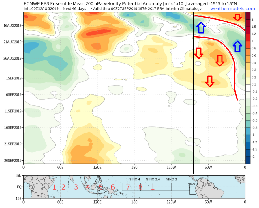
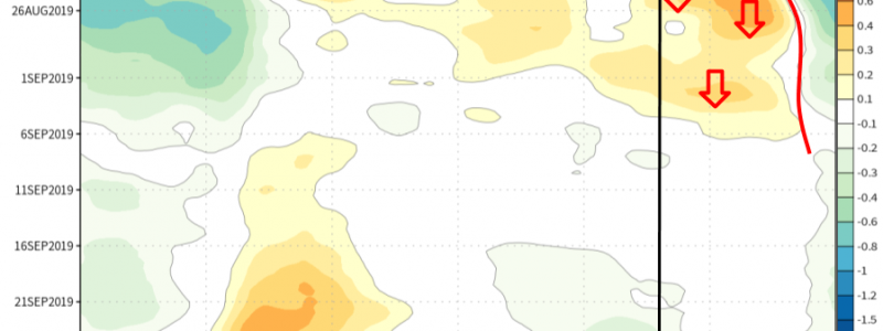
The best way to pick out large scale patterns of rising or sinking air is via Velocity Potential Anomaly Hovmoller diagrams like the one shown below. I won’t go into the vector calculus behind the physical quantity Velocity Potential (though if you’re interested, the AMS Glossary has a quick overview) but positive VP anomalies generally favor sinking air while negative VP anomalies generally favor rising air. What’s the Hovmoller thing about? A Hovmoller diagram has time increasing down the y-axis while longitude marks the x-axis. It’s a way of visualizing how the spatial distribution of something (in this case VP anomalies) in a given latitude or set of latitudes (in this case 15N to 15S) changes over time.
As you can see, at the beginning of the forecast period (that’s now), the basin is dominated by sinking motion. That explains our current lack of activity. A brief period of predominantly upward motion is expected beginning this weekend and lasting through early next week. After that, the upward motion will become more confined to Africa while the Atlantic sees sinking motion. What does all that suggest? Beginning next week, we’ll likely see an increase in tropical wave activity. I don’t think the pulse of rising motion will be either strong enough or long-lasting enough to produce a series of tropical cyclones (remember we still have all that dry air to contend with). That being said, a prolonged period of generally upward motion over Africa will help give the tropical wave train a boost, which would lead to an uptick in activity by the week 2-3 timeframe. Whether any individual wave actually gets its act together enough to develop into a tropical cyclone is another question, which we won’t be able to answer until much later. Chart via weathermodels.com.
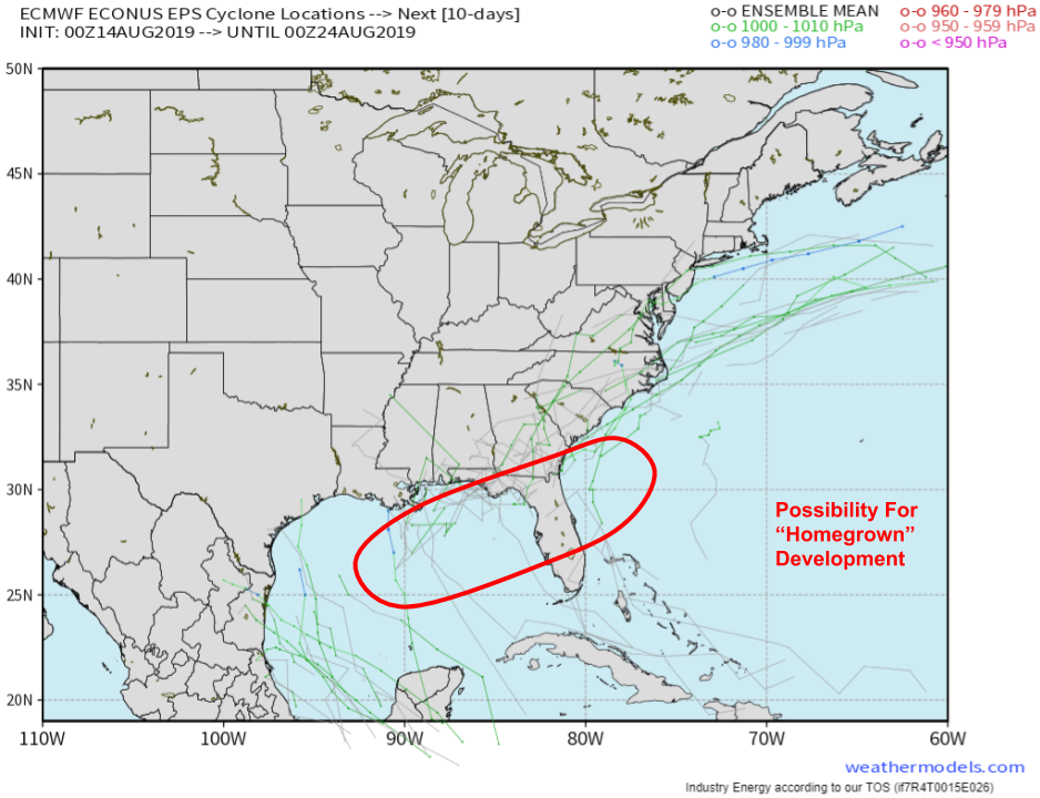
While conditions will remain generally unfavorable for tropical activity across most of the basin for the next week or two, pockets of favorable conditions can still come together closer to the US. One way a storm can develop in this area without a tropical wave is if a cold front pushes offshore then stalls. The thunderstorm activity along the cold front can move enough mass upwards to create its own low pressure area. This low will then help produce more thunderstorms, which will lower the pressures further, and so on until a tropical cyclone is born. While there are currently no specific threats of this occurring, EPS guidance hints at the possibility towards the end of the upcoming 10 day period. The most likely place for “homegrown” tropical development would be in the NE Gulf of Mexico or the far SW corner of the Atlantic Ocean just north of the Bahamas. Map via weathermodels.com.
When specific tropical threats present themselves this hurricane season, we’ll have a breakdown here as always. Until then, it’s never too early to think about your hurricane plan and stock up on any supplies needed for your emergency kit. Planning for a storm well ahead of time is important, and even if that plan doesn’t get used this hurricane season, eventually everyone’s luck will run out sometime in the future. For more info on hurricane preparedness, please consult the National Hurricane Center’s resources.
-Jack
