What Are Tropical Waves, How Do They Form, And Why Are They Important?
Hello everyone!
The US rarely gets direct impacts from tropical waves, and when that does happen it’s almost always confined to parts of southern Florida. Despite the fact that these features usually stay hundreds or thousands of miles to our south/east, their role as tropical cyclone seeds makes them very important to anyone with interests in the Eastern/Central part of the country during the summer and fall months. So what are tropical waves and how do they form?
Tropical waves are perturbations within the low/mid level easterly trade winds just north of the equator. Ahead of the wave axis, winds turn a bit more northerly (NE) and behind the wave axis, winds turn a bit more southerly (SE). This shift in direction causes convergence, and thus rising motion. If there’s enough moisture and instability, the waves will produce thunderstorm activity.
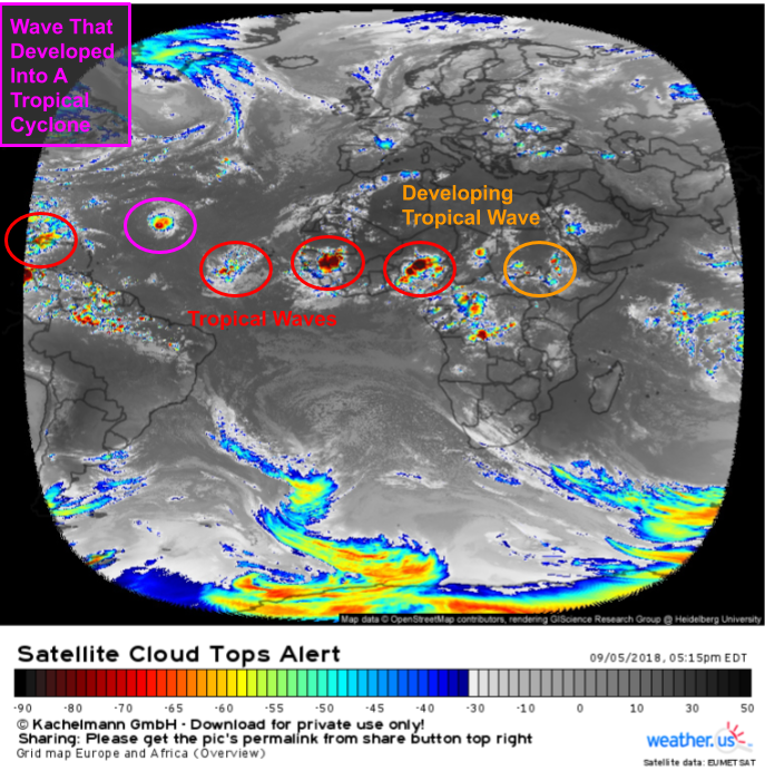
This satellite image from September 2018 shows a series of tropical waves stretching from East Africa all the way into the Western Atlantic. Four of the waves are in fairly typical form, with disorganized shower and thunderstorm activity along their SW-NE oriented axes. The wave over the Central Atlantic has developed into a tropical cyclone (Hurricane Florence) while the easternmost wave over South Sudan is just beginning to develop.
So how do tropical waves develop? The answer lies in a feature known as the African Easterly Jet.
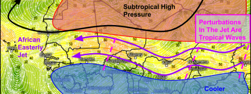
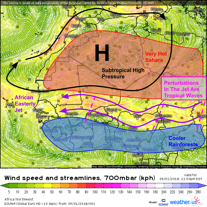
Here’s the ECMWF’s forecast for winds at about 10,000 feet a few days before the satellite image shown above. The African Easterly Jet is clearly visible as a region of brisk easterly winds along the boundary between the extremely hot Saharan desert and the relatively cooler coastal rainforests farther south. This temperature gradient is responsible for that jet, which shifts north or south with the seasons. Like any jet stream, the AEJ wobbles slightly north or south as it moves generally from east to west. These wobbles can come from interaction with the higher terrain of Eastern Africa, the development of persistent thunderstorm activity, or just the instability inherent to the boundary between two different airmasses.
Through thunderstorm activity, these wobbles eventually manifest themselves as troughs of surface low pressure embedded within the near-surface easterly trade winds, and tropical waves are born. As these waves move west off the African continent, they often lose most of their thunderstorm activity as even the tropical Atlantic waters aren’t nearly as warm as the land heated by the strong tropical sun. However, if conditions are right, that thunderstorm activity can persist over the ocean. If the storms become organized enough, the system can be classified as a tropical cyclone.
Many Atlantic tropical cyclones can trace their roots to tropical waves emerging off the African coast, though the vast majority of tropical waves never develop into tropical cyclones.
-Jack



FINALLY!…FINALLY I find the detailed explanation I’ve searched for, over the years, explaining just how an African wave is created! Thank you!
On another subject, could the moon graph the lead hurricane forecaster at the San Juan, Puerto Rico Hurricane Forecasting Office used to post on the wall each month in the late 1960’s and early 1970’s indicating periods of favored days for cyclogenesis—usually 3 days or so after a full or new moon—and which often enough worked out(not always though; could that have been a crude, raw depiction of the MJO before it was discovered??
And one more thing for now: how can I BOOKMARK that colorized, IR satellite image by EUMET of Africa so I can follow the westward progress and intensity of each wave every day? The closest to it I’ve found is a visual daylight only image with all clouds and storms colored solid red—no rainbow colors showing precip intensities!! Thanks
Hi Robert,
I’m glad you found this article helpful! To answer your questions:
1. The hypothesis that cyclogenesis is favored roughly twice each lunar cycle (every ~14 days) would reference a wave pattern too fast to be the MJO which wobbles around the world roughly once every month or two. A phenomenon similar to the MJO, known as Convectively Coupled Kelvin Waves (CCKWs) tends to move faster and might be the pattern that forecaster was keying into. However, to my knowledge, there is no known connection between CCKWs and the moon, nor do CCKWs follow a strictly 14 day period.
2. The latest version of the EU METSAT IR image I used in that post can always be found here: https://weather.us/satellite/europe-africa/top-alert-15min.html. Bookmark away! Remember though that this map isn’t showing you precipitation intensity directly, but merely cloud top temperatures (a good proxy in the tropics).
Hope this helps!
Jack
Good article, thanks.
Looks like you had a typo “Like any jet stream, the AEJ wobbles slightly north or south as it moves generally from west to east.” I think you meant from east to west for the AEJ.