Tropical Disturbance 91L To Bring Another Round Of Rain To The Southern Plains This Week
Hello everyone!
The 2019 Atlantic Hurricane Season officially kicked off yesterday, June 1st, and we’re already watching a disturbance in the southern Gulf of Mexico, dubbed 91L by the NHC, for possible development. At this point, development into a significant tropical cyclone is very unlikely, but it’s possible that the system will head for Texas as a low end tropical storm before adding even more moisture to an already-waterlogged Great Plains. This post will outline the forecast for this system over the next few days and what its impacts might be.
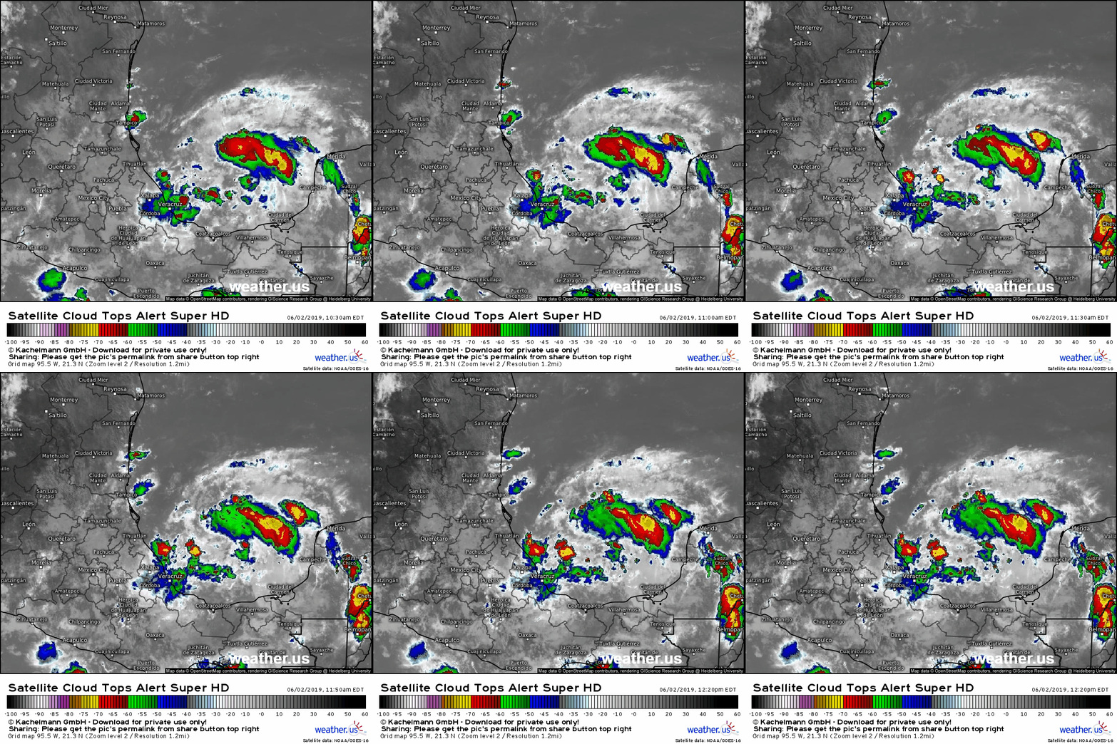
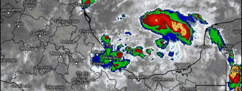
Here’s a look at the system through GOES-East’s IR lens. You can pick out some weak rotation of clouds and showers near the ‘center’ of the system located about halfway between Tampico and Campeche. The system has limited amounts of thunderstorm activity, shown by the lack of a consolidated area with cloud tops below -70C (that’s a good general benchmark for intense thunderstorms). At the moment, the lack of widespread thunderstorm activity and the lack of a well-defined center of circulation mean that this is a disorganized disturbance in no danger of rapid intensification.
In spite of the mitigating factors, the loop above does show one feature favorable for development: upper level divergence. Note the wispy cirrus cloud moving ENE to the north of the storm and SW to the south of the storm. The divergence of winds in the upper levels is one process that can encourage more rising air, and thus continued development of thunderstorms near the center of the disturbance.
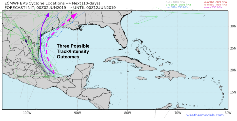
What does the future hold for 91L? EPS ‘spaghetti’ tracks via weathermodels.com show three general possibilities for its track, which will highly influence its intensity. The farther west the storm goes, the more it will interact with the mountains of Mexico, which will keep it a weak and disorganized disturbance. A track farther east would give the system more access to fuel in the form of warm water, which would help facilitate more development. Currently the consensus of available guidance points to a most likely track relatively close to the Mexican coast before the system moves onshore in far southern Texas. This would likely give the system enough time to develop into a tropical depression or weak tropical storm before landfall. If the storm moved farther east, development into a mid-grade TS would be possible. Keep in mind that no currently available forecast suggests this disturbance would develop into a hurricane, and this conclusion is supported both by climatology and environmental conditions.
For more info on ensembles, check out this tutorial video.
Because intensification into a strong cyclone is not expected, the biggest impact from 91L will be its ability to send very deep tropical moisture north into the Plains during the midweek timeframe. The above animation shows that moisture in the form of a red/pink blob indicating precipitable water values in excess of 2″. As this moisture interacts with an upper level disturbance moving in from the west, another round of heavy rain is expected for the Plains. GIF via weathermodels.com. 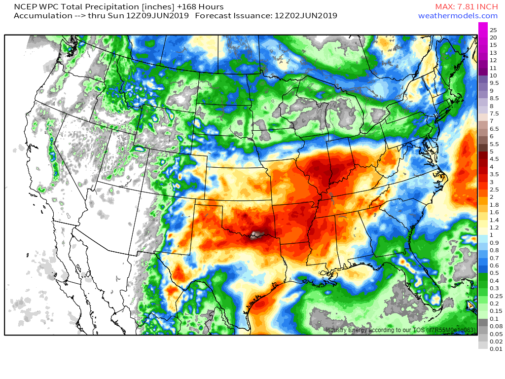
This map via weathermodels.com shows the forecast total rain for the next 7 days as 91L’s moisture meanders slowly from Texas up into the Mississippi and Ohio river valleys. Keep in mind that the ability of this particular forecast technique to account for the small-scale influences of thunderstorm activity is limited, so amounts will locally be much higher than what’s shown here. That being said, a wide swath of 2-4″ or more of rain is expected from Oklahoma through Indiana, a region that is already experiencing major flooding after weeks of heavy rain.
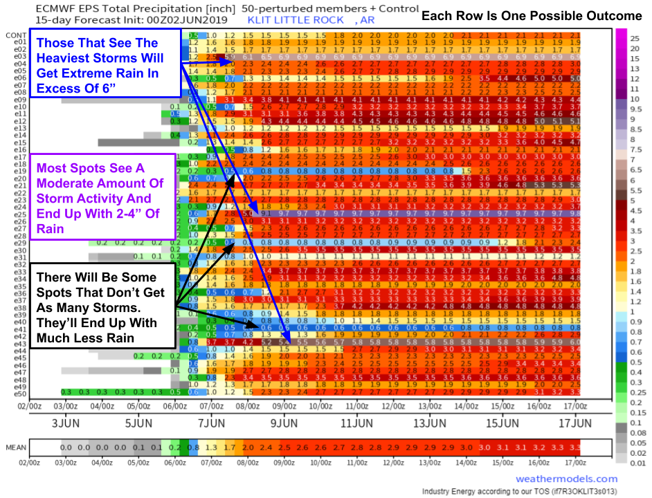
One good way of visualizing uncertainty in rainfall forecasts is with our EPS city charts tool at weathermodels.com. Each row represents the rainfall forecast from one of the 51 EPS ensemble members. No one member is particularly likely to nail the forecast, but taken together, the full suite of ensemble guidance helps to paint a picture of what possible outcomes might look like. These plots are constructed for one city at a time, in this case Little Rock AR. However, they can also be used to think about possible trends across nearby areas, especially in situations like this where rainfall totals will depend heavily on exactly how/where thunderstorms set up.
For more info on ensembles, check out this tutorial video.
In this case, we see that each ensemble member’s forecast falls roughly into one of three groups: a lot of rain (few members support), a medium amount of rain (most members support), or a very small amount of rain (few members support). For Little Rock, this means that the most likely outcome is roughly 2-4″ of rain, but the outliers signal that small scale dynamics could tip that number either much higher or much lower.
If we want to extrapolate this to a spatial forecast, we can think of each possible outcome for Little Rock as the ‘actual’ outcome for a point near Little Rock. A few points will sit under the heaviest and most persistent storms, and will end up with a lot of rain (>6″). Most points will get hit by some storm cells, but not others, and will end up with a medium amount of rain (2-4″). A few points will luck out and dodge nearly all the storms, ending up with .5-1.5″ of rain. We don’t know exactly where those points will be, but we do know that there will be considerable local variability in precipitation totals.
The bottom line here is that 91L is *not* a major tropical cyclone threat. It may develop into a weak or even moderate Tropical Storm, but neither wind nor storm surge will have a major impact. Instead, the system’s primary impact will be in the form of heavy rainfall for the Plains as the remnant moisture moves north during the middle of the week.
Give us a follow on twitter for the latest info on the storm as it evolves over the next few days: @WeatherdotUS, @RyanMaue, and @JackSillin.
-Jack
