5/16-5/18 Severe Weather Discussion (Overview)
Hello everyone!
This weekend will be a very active one for severe weather as a big upper level trough emerges out of the Rockies onto the Plains. This post will discuss the overall pattern and why it’s so favorable for severe storms. I will have separate posts for each day’s threat (today, tomorrow, Saturday, and Sunday) coming over the next few hours so keep checking back if you’re interested in more specific info. All the data I use here is accessible on weather.us and/or weathermodels.com. Click any image to be taken to its respective page on the sites.
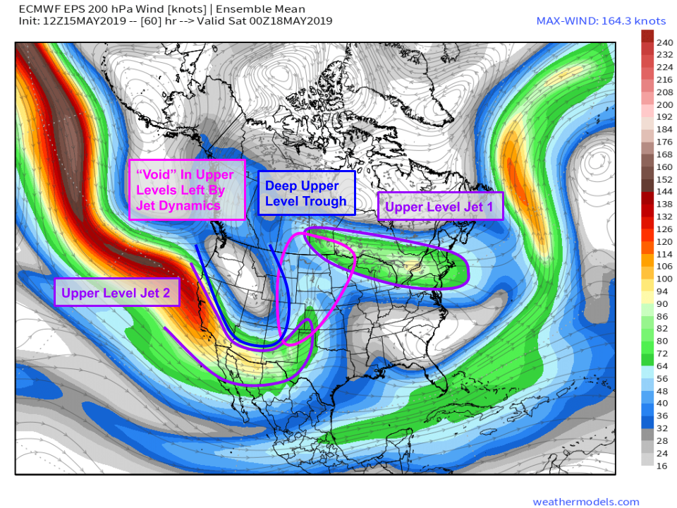
This map gives a good top-level overview as to why this weekend will feature conditions broadly favorable for severe weather. A deep trough will be located over the Rockies, with disturbances rotating around its base. Those disturbances help to spark thunderstorm activity if sufficient moisture/instability is present. Additionally, two jet streaks will be present in locations that are strategic for creating an environment favorable for severe thunderstorms. Winds will be diverging aloft over a good part of the Central/Northern Plains between these two jet streaks, which will leave a ‘void’ so to speak in the upper atmosphere. If more air is leaving an area than entering it, the pressure goes down. The atmosphere then attempts to ‘fill’ that gap, which leads to the next aspect of our discussion.
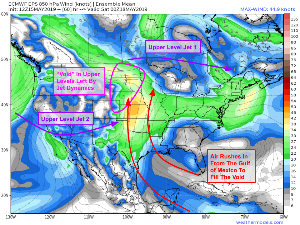
The filling of the upper level low pressure area is accomplished primarily by air rising out of the low/mid levels. If we sketch in our upper level ‘void’, we’ll see that a new ‘void’ is created in the lower levels over the Northern Plains. Indeed, if you look closely, you’ll see an area of low pressure (with counterclockwise spiraling winds) located over Nebraska in this lower level forecast valid at the same time as the map above. Remember, the atmosphere is always trying to equalize its pressure, so air needs to move horizontally now to fill this lower level ‘void’. That air will be coming from the Gulf of Mexico, and will be riding north on a strong LLJ (lower level jet). Air coming from the Gulf of Mexico carries with it abundant moisture, meaning we have another ingredient necessary for severe thunderstorm development in place.
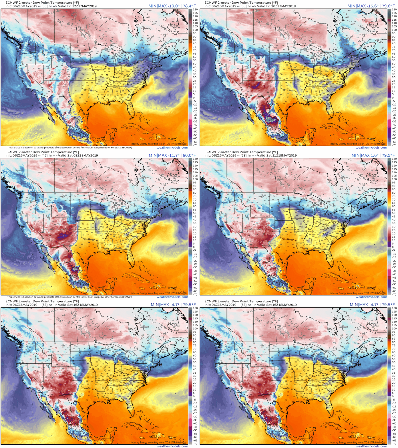
At the surface, we have numerous features that will be important to watch over the next few days. All of them show up on this dew point animation from Friday morning to Saturday midday. The most important feature will be the dryline, a very sharp moisture gradient separating dry air from the Mexican and Southwestern deserts from moist air originating in the Gulf of Mexico. Like any boundary between airmasses, the dryline promotes converging air near the surface, which results in rising motion. If sufficiently strong, this rising motion can initiate thunderstorm development. The other feature to watch will be the long warm front stretching from Nebraska wast towards the Great Lakes. This feature is dynamically much different than the dryline, but it too will feature rising motion and thus possible thunderstorm development.
Both the dryline and the warm front will be closely watched over the next few days as the approaching trough brings additional rising motion and strong upper level winds (which will increase wind shear).
-Jack


