Severe Storms Tonight Kick Off Several Days Of High-Impact Weather
Hello everyone!
An intense storm system will develop over the Plains tonight and tomorrow, featuring the full range of high-impact weather. The first aspect of the storm will be severe weather, which begins across Texas and New Mexico tonight. This post will focus on that part of the system, with later updates to outline the other impacts from blizzard conditions to strong winds to flooding rains.
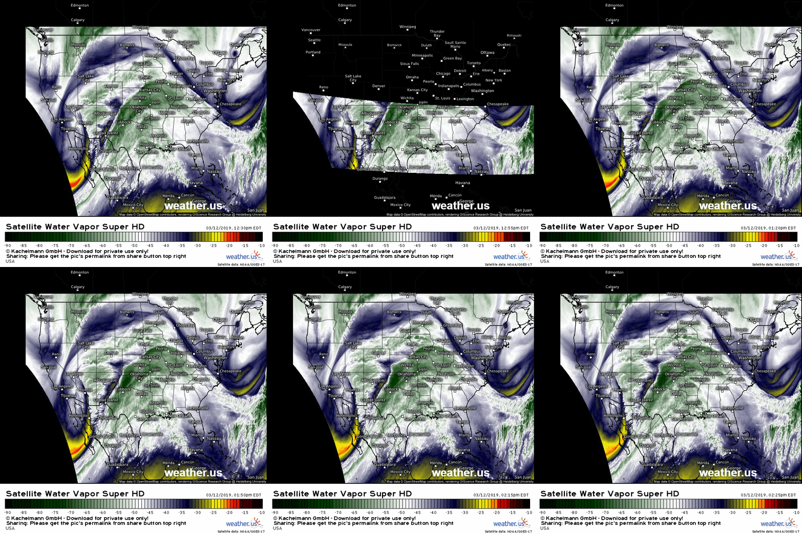
The reason we’re worried about severe weather is clearly visible on WV satellite imagery this afternoon. A deep and unusually strong upper level low pressure system is spinning over far NW Mexico, with strong upward motion visible out ahead of it. The system is also tapping a strong feed of deep tropical moisture from the Eastern Pacific, which you can see has already made it up into the Plains. As the upper level dynamics associated with this system encounter unstable Gulf of Mexico air over W TX and E NM, storms will quickly take off.
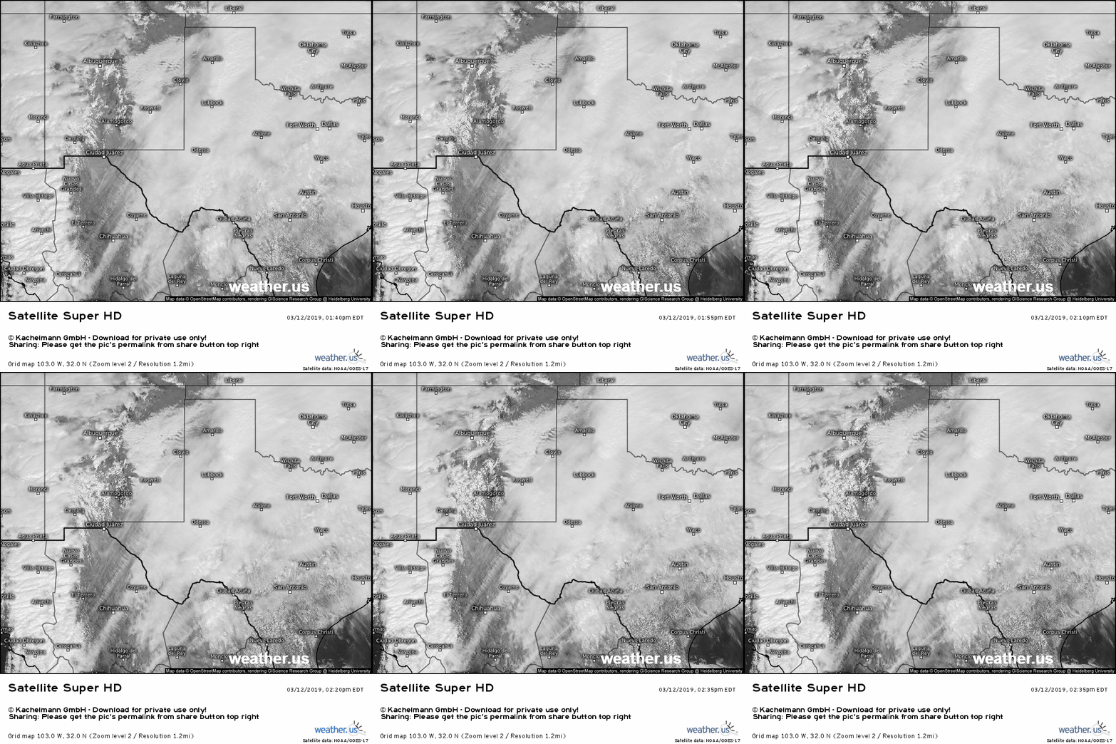
Visible satellite imagery helps to add some more detail and nuance to our understanding of the environment, showing individual areas of cloudiness and sunshine. A few important features to note here are include the area of sunny skies in Central NM, the low clouds in Eastern NM, the fast-moving low level clouds over SE Texas, and the band of striated cloud cover racing north over Mexico. What is the significance of each of these features? The sunny skies over Central NM are helping to destabilize the atmosphere by raising the surface temperature. The low clouds over E NM/W TX are holding temps down, which is preventing more robust instability from developing. Those clouds over SE Texas indicate strong low level moisture advection from the Gulf of Mexico, which may help offset some of the cooler temps in terms of instability. The last feature, those striped clouds over Mexico, indicate very strong upward motion along the cold front. Once that upward motion finds the instability, we’ll have storms!
As storms develop, here’s a look at the environment they’ll encounter, visualized by the ECMWF’s Thunderstorm Composite map. A plume of unstable air will be found just ahead of the cold front, though the exact magnitude of that instability will depend on whether those stubborn low clouds over E NM/W TX can break up in the next few hours. Shear profiles highlight the potential of the setup well. Strong SE surface winds will be located underneath a screaming southwesterly jet at 500 and 300mb (above 25,000 feet). The change in wind direction with height is notable, but the magnitude of the wind speeds involved will help to provide an extremely favorable kinematic profile for cells developing along and ahead of the cold front.
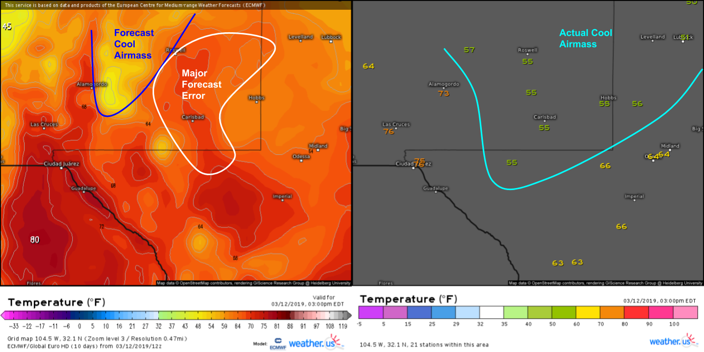
One possible inhibiting factor for severe weather will be the cooler-than-forecast surface temperatures over SE NM. The image on the right shows the ECMWF’s forecast temperatures for 1PM MDT, while the image on the left shows observed temps at the same time. Note the large area with forecast temperatures in the mid to upper 60’s while actual observations showed temps in the mid 50’s. Cooler air is much heavier, and thus less buoyant, than warm air, so storms that ingest this cold air will have a hard time intensifying. This could be overcome either by sufficient forcing for ascent (rising motion), sufficient moisture advection (moist air is less dense than dry air, so more moisture could offset some of the cooler temps), or if those low clouds break up in the next couple hours.
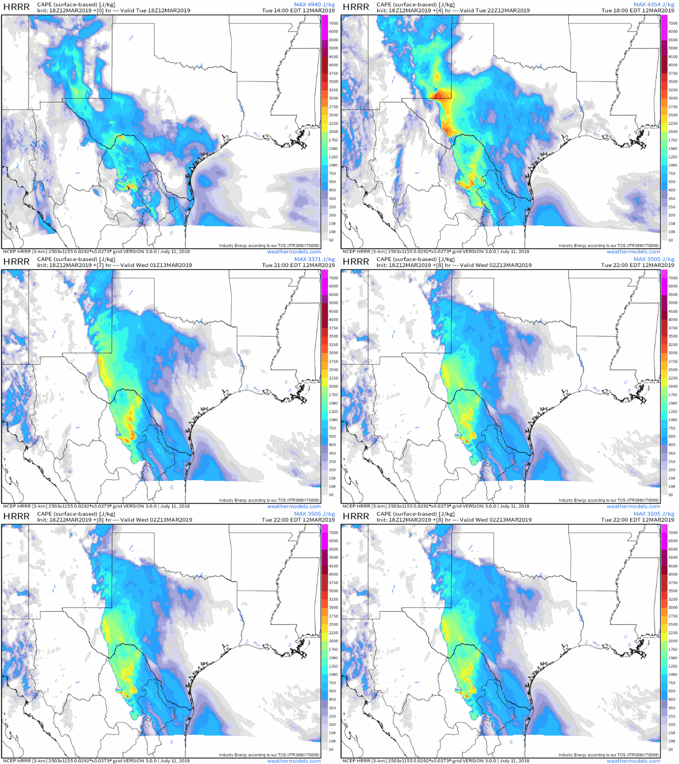
Here’s the HRRR’s near term instability forecast on the left, and it’s dew point forecast on the right. The model has figured out that low cloud cover is resulting in less instability over far SE NM currently (at the beginning of the forecast loop) but shows a quick increase in available instability over the next few hours as warmer/moister air is advected in from the Gulf of Mexico (that’s the loop on the right). Keep an eye on those temperature and dew point observations as we head into the evening, they will be the best indicators of the severe potential across SE NM, alongside satellite imagery of course. GIFs via weathermodels.com.
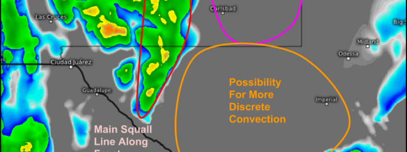
Here’s a look at what the radar might resemble by 5 PM MDT. The general thinking is that SE NM will provide an environment conducive to supercells, should the surface destabilize sufficiently. The model forecast provided has selected the area between Roswell and Hobbs to spin up a cell, but the reality is that anywhere in the pink circle has an approximately equal chance of seeing a supercell. If that cell (or two) forms, strong tornadoes, extremely large hail, and violent straight-line winds would all be expected. The environment here is supercharged with shear, so if instability is sufficient, the storms will be quite intense. Farther south, more discrete supercell development is possible in W TX, with possible impacts similar to those in NM. The timeframe might be a little later, after 5-6 PM MDT/4-5 PM CDT. Farther west, a squall line will be organizing along the front during this time with tornadoes and damaging winds being the primary threats.
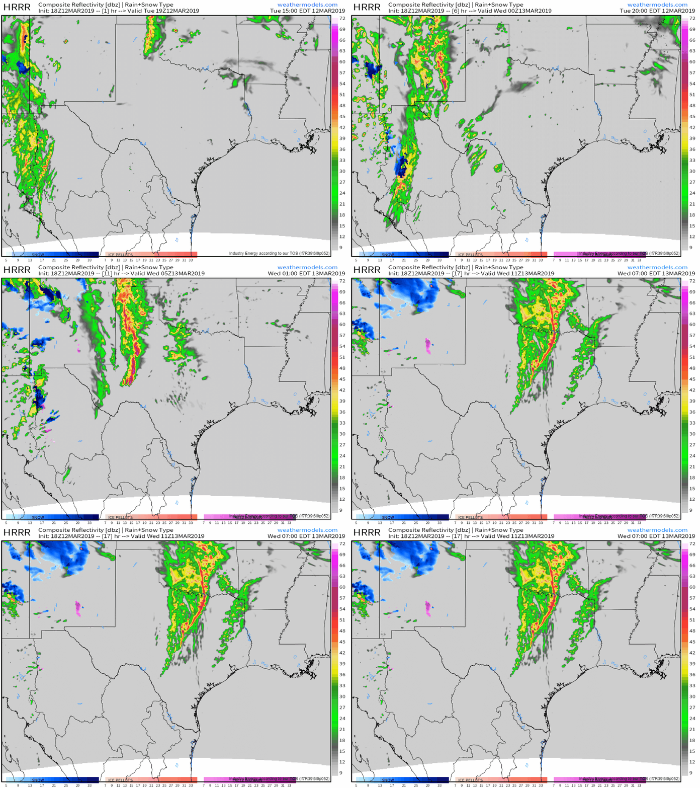
On the larger scale, here’s how the storms will evolve from initially being discrete entities this afternoon/evening, towards a more linear squall line structure later tonight. The threats from these storms will shift along with the storm mode, from strong tornadoes/large hail/damaging winds associated with the supercells towards more brief (but no less dangerous!) tornadoes and more widespread damaging winds associated with the squall line. Be sure to keep an eye on radar imagery if you’re in the path of the storms, and of course have a way to stay updated with any warnings issued by your local NWS office. GIF via weathermodels.com.
Our team will have updates on this system through the evening on twitter @WeatherdotUS, @RyanMaue, and @JackSillin.
-Jack
