Into The Icebox
Hello everyone!
Now that we’re almost entirely through the month of January, it’s time for a blast of Arctic air that’s impressive by any standards. The cold will come in two parts, the first of which is ongoing now, and the second of which will begin to arrive early this coming week. While this first round is impressive, wave two is where you’ll find the even more impressive cold. So what’s causing the deep freeze and how bitter will it actually get?
Round one has already thrown down some pretty impressive numbers this morning, as shown by our observed temperature product. Note that we archive temperature data (all our data actually!) so you can go back and compare the upcoming forecast to previous cold blasts you might remember from years past. Many parts of the Midwest east of the Red River valley saw temps below zero this morning along with enough of a breeze to make wind chills dangerous.
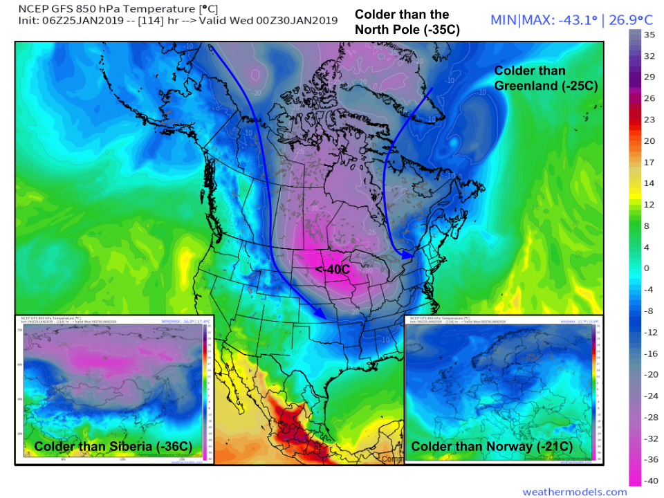
So how will round two be different? This comparison of Dynamic Tropopause maps from the GFS model highlights how the upper level setups are considerably different between the two events. This first round has the main lobe of the Tropospheric Polar Vortex (TPV) remaining well north in Hudson Bay. It’s only a small appendage that’s drifting down into the Great Lakes. By next week however, the main TPV lobe this side of the Northern Hemisphere will take up residence over Wisconsin. That means the coldest of the cold air anywhere in the Northern Hemisphere will be right over the Midwest. Don’t believe me? Let’s compare temperatures across various parts of the globe on Tuesday night. Maps via weathermodels.com.
These maps show the temperature at 850mb (around 5,000 feet) and is a preferable proxy for airmass evaluation because surface conditions can trip the models up (figuring out if a given place has bare ground/snow/ice/water/mountains etc.). Just because temps aloft are colder doesn’t mean that surface temperatures will actually be colder than somewhere else, but it is notable that the coldest airmass in the Northern Hemisphere will be located over the Upper Midwest. 5,000 foot temps are a good way to talk about the airmasses, but most of us east of the Rockies don’t live at that altitude, so what’s the forecast down at the surface? Spoiler alert: still really cold. Maps via weathermodels.com.
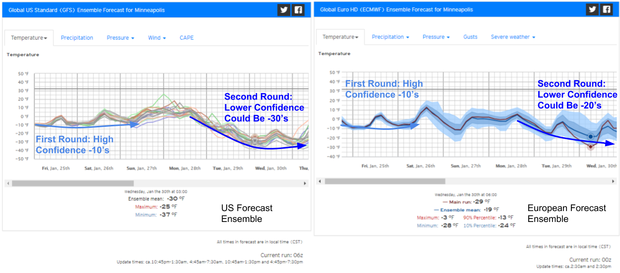
A comparison of US and European ensemble forecast system forecasts shows that some disagreement still exists regarding the extent of the second round of cold. American guidance is more bullish on temps dipping into the -30’s in places like Minneapolis (shown above), while the European preference is temps in the -20’s. Either way, it’s going to be really cold. The question is mostly whether record breaking levels are reached
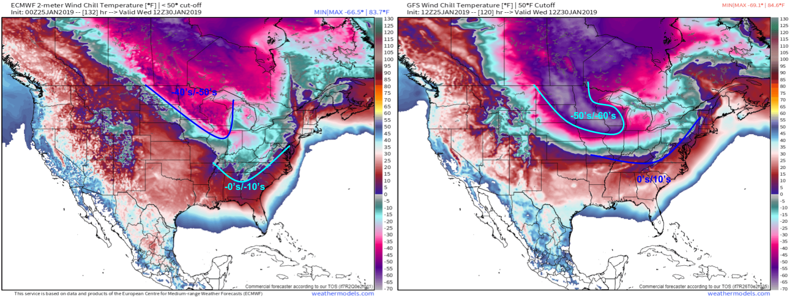
While we watch for continued refinement of temperature forecasts, the dangerous wind chill forecast is all but a lock. The uncertainty at this point revolves around whether wind chills dip into the -50’s/-60’s or “only” the -40’s. Either way, limit time spent outdoors, and be sure to cover all exposed skin if you’re planning on venturing out even if it’s just for a minute. The cold will also be felt farther to the southeast, with below zero wind chills possible as far south as Atlanta. Wind chills in the teens are possible nearly to the Gulf Coast if the Arctic airmass takes the more “nose down” approach, digging farther south as opposed to translating east. Maps via weathermodels.com.
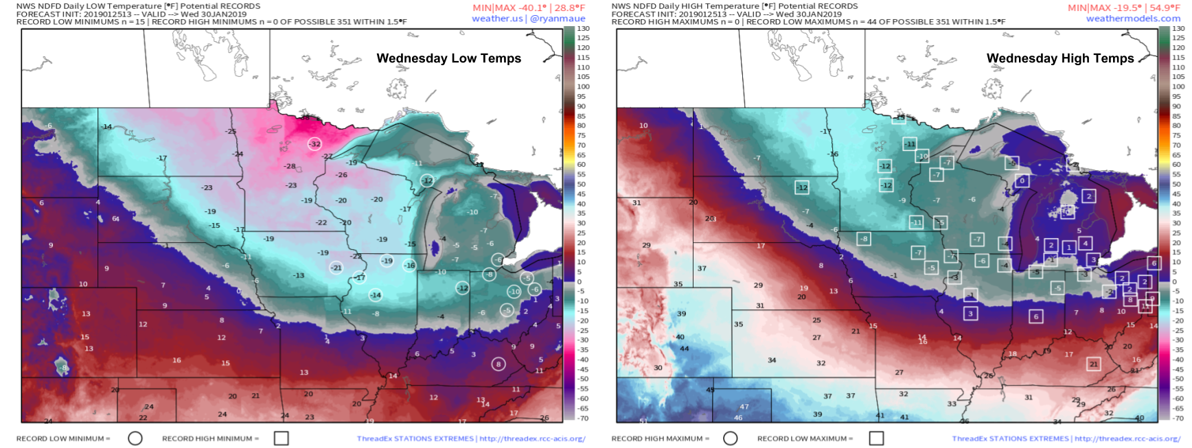
So what about the records? They’re certainly possible. Several record low minimum temps are forecast Wednesday morning, with many more record low maximum temps on Wednesday afternoon. This data is from the NWS and takes into account all available model guidance plus expertise from local meteorologists. A wide swath of record cold in the upper Midwest during what’s climatologically the coldest couple weeks of the season is really notable! Maps via weathermodels.com.
Just how cold will it be in your town? Find out by going to weather.us and typing your location into the search box. From there, you can navigate to our Forecast Ensemble and Forecast XL products which will give you a good sense of the range of possible outcomes for your town.
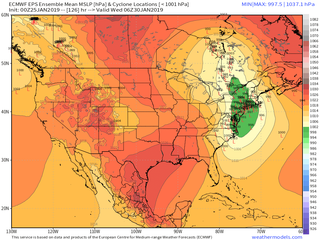
As a quick side note, a storm will likely develop on the leading edge of the Arctic air on Tuesday night. As you can see, there’s still plenty of disagreement about the system’s exact track/intensity, but at this point more rain/wind is a good bet for the I-95 corridor while heavy snow is possible farther north in the mountains. I’ll have a more detailed rundown of this system either Sunday night or Monday morning. Map via weathermodels.com.
-Jack


