Major East Coast Storm Begins Today
Hello everyone!
The major winter storm set to unfold across the East Coast over the next couple days was discussed in detail yesterday morning. Please refer to that post for a description of some of the dynamics behind this system, as well as talk about freezing rain accumulation (and why it’s so hard), jet divergence (why it causes upward motion), thermal clashing (why it’s important to the forecast), and more. This post will discuss one new overnight development that shifts the forecast around a little bit for some areas: an area of much stronger than expected thunderstorm activity over the Southern MS Valley.
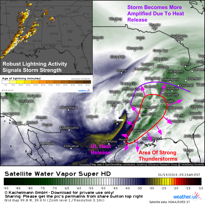
Morning WV satellite imagery and lightning analysis both clearly highlight this area of storminess stretching from SE TX through the Lower MS Valley towards Missouri. So why does that change the forecast? Those storms are releasing tons of heat into the upper atmosphere as they force water droplets to condense/freeze. If you remember yesterday we talked about latent heat and why water molecules changing from a higher energy state to a lower energy state releases heat into the surrounding air. The same process is going on here! Trillions of water vapor (gas state, highest energy possible) molecules are turning into liquid (droplets) and solid (ice crystal) form up in the upper atmosphere, releasing tons of heat as they do so. That heat is boosting geopotential heights to the east of the storm system, making the upper level wave more amplified.
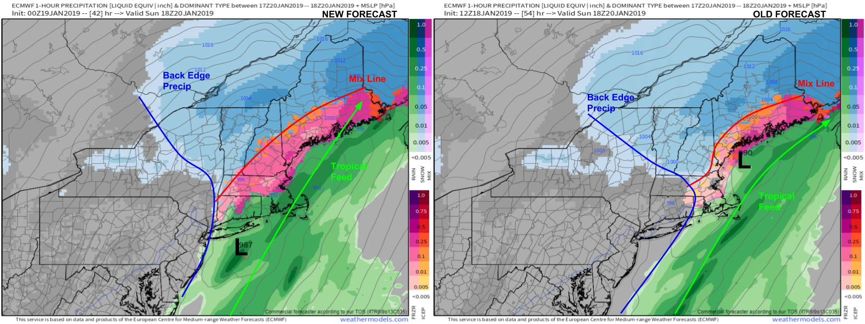
Why is a more amplified wave important? Here’s a comparison of the most recent ECMWF guidance with yesterday’s forecast for the same time (1 PM tomorrow). The more amplified storm means a few things. First, more precip falls farther NW. Notice the new forecast for heavy snow across VT where the old run had just light snow. Second, warm air is able to penetrate farther NW aloft. Notice the mix line extending much farther into NH/ME in the new forecast compared to the old forecast. Third, the tropical moisture feed is pointed farther north, leading to heavier precip (this explains point one). Finally, dry air doesn’t move in quite as fast on the back side of the system, meaning that precip is able to continue for a longer period of time. Notice how the old forecast had the back edge in E CT/Central MA while the new forecast has it barely clearing the Hudson Valley. Maps via weathermodels.com.
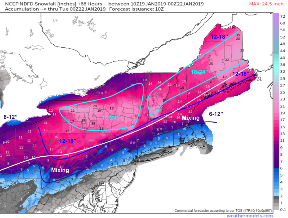
What’s the net result for the snow forecast? Not much change outside of those areas right on the border between rain/mix/snow. Southern New England now looks to see more sleet/ice and less snow, but the big dump is still full speed ahead from Central NY through Northern New England. In fact, the increased amplification may actually deliver more precip to parts of N NY and N VT that previously seemed to be on the northern edge of the system. However with more precip comes warmer temps, and slightly less optimal snow growth. Thus ratios may be slightly lower, so on balance it’s hard to tell whether to expect a little more or a little less snow. But for ski areas, if your forecast challenge is 22″ vs 26″ vs 30″, well that’s a good problem to have. Map via weathermodels.com.
Behind the storm, attention will shift to an incoming blast of Arctic air. This animation shows temps falling fast as the storm departs, with readings dropping to near zero by Monday morning. While it remains to be seen just how low temps will go, there is another threat with the sudden cool down: flash freezing. Parts of the coastal plain that see plain rain will go from 50 to 15 in just a few hours. This means that all the puddles/moisture on roads/sidewalks etc. will quickly turn to ice. Be sure to watch your step heading out the door on Monday and use extra caution on the roads as conditions will look a lot different than even 3-6 hours prior. GIF via weathermodels.com.
Follow along with the storm today and tomorrow using the storm tracking tools we have at weather.us including GOES-East satellite imagery, HD radar imagery, and current observations (click any weather.us map to zoom in for a closer look!). The latest model forecasts can be found both at weather.us and weathermodels.com. Additionally our team will be tweeting out updates @WeatherdotUS, @RyanMaue, and @JackSillin.
-Jack


