Large Storm To Bring Heavy Rain And High Winds To The East Tonight Through Tomorrow
Hello everyone!
The storm that brought severe weather to Florida today will move north tonight and tomorrow, dragging deep tropical moisture with it. Threats from this system will come in various forms including heavy rain, strong winds, and coastal flooding. Thankfully, the system should be a fairly quick mover with quieter weather returning for the weekend.
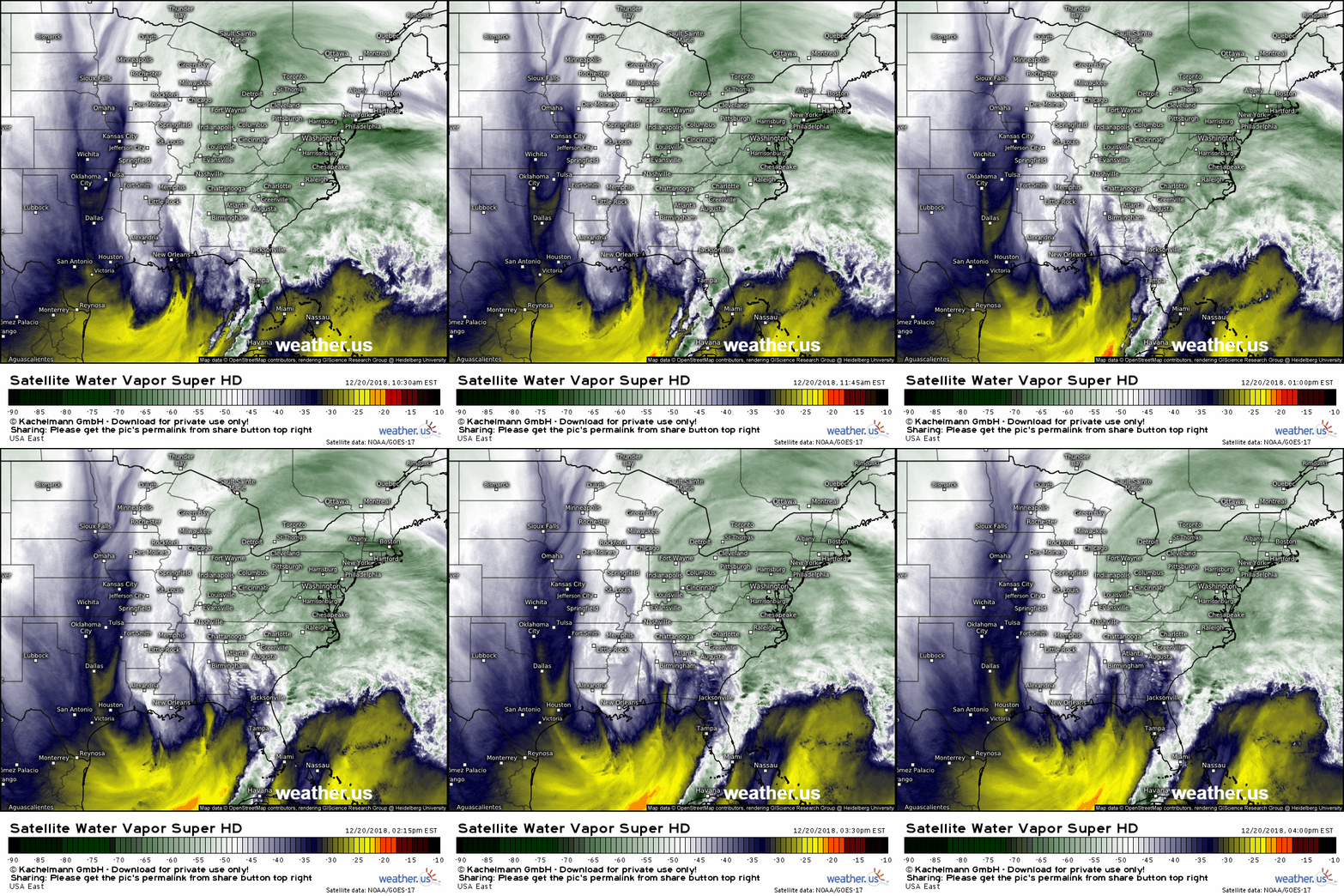
Here’s a look at GOES-East WV satellite imagery this afternoon, which clearly shows the strong upper level low responsible for the storm, as well as its strong moisture plume. The first phase of the system produced severe weather in Florida this morning and the next phase is set to begin tonight as the storm turns north up the coast.
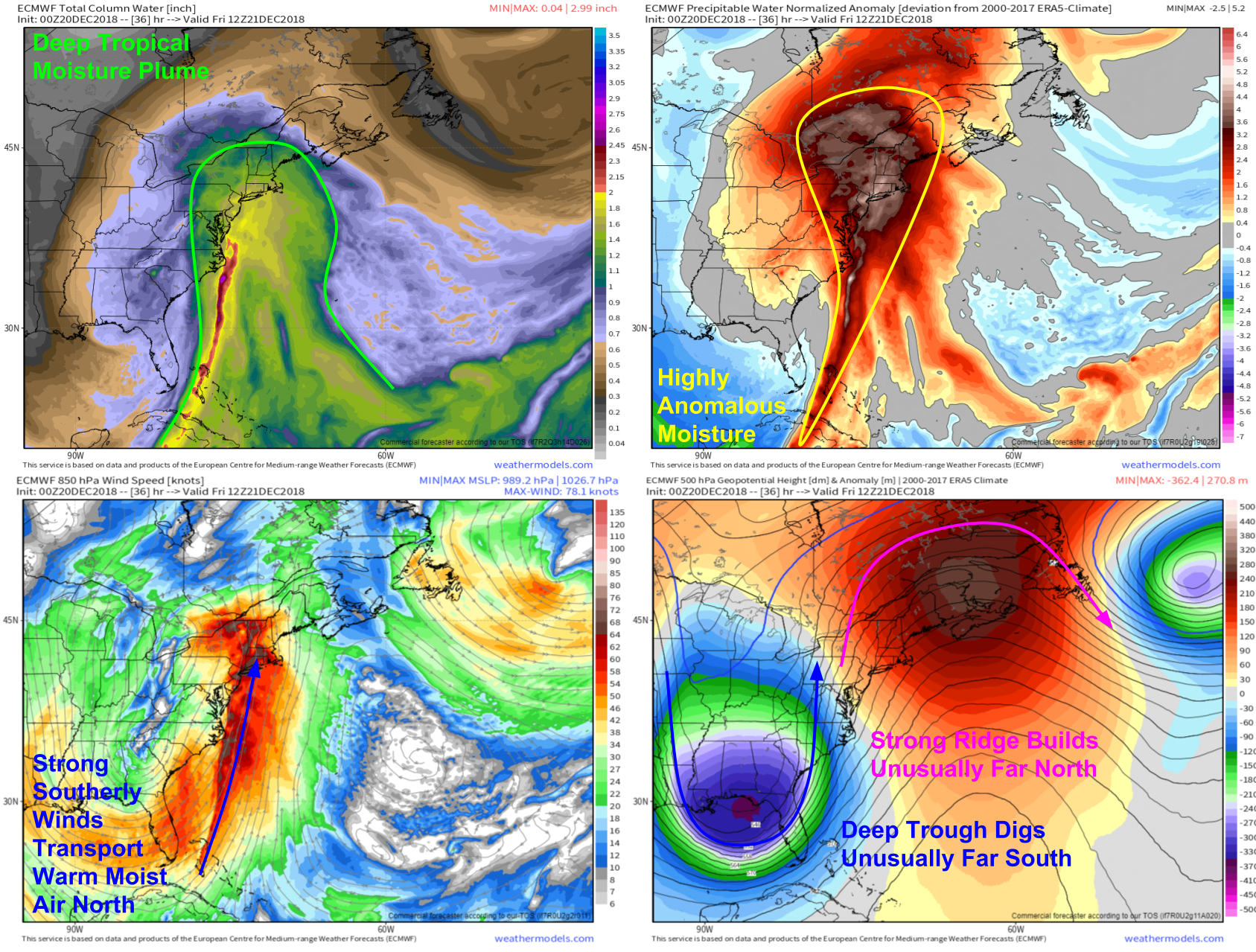
Here’s a look at four different factors going into the primary threat from this system, heavy rain. The top left map is a parameter known as Precipitable Water which measures the amount of moisture in the air. The top right map shows how anomalous those moisture values are. The red values indicate areas with more moisture than is typically expected for this time of year, with the dark reds/light pinks highlighting extremely unusual values. That moisture is getting funneled north by strong southerly winds between an unusually deep trough over the Southeastern US and an unusually strong ridge over Maritime Canada. Maps via weathermodels.com.
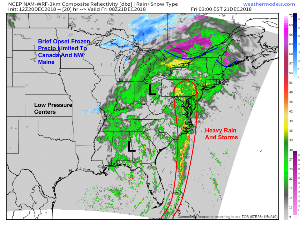
With the pattern well established, what will the actual weather look like tomorrow? The NAM model’s simulated radar parameter gives a decent overview while of course not necessarily picking up on the exact locations of individual cells. The main takeaway is the band of heavy rain and storms moving from south to north on the eastern flank of the system. That band is where the worst weather will be, including the heaviest rain and the strongest wind. The band will impact the Mid Atlantic late tonight/early tomorrow morning before moving northeast towards New England tomorrow afternoon/evening. While freezing rain will briefly impact parts of Maine tomorrow morning, all frozen precip types will quickly turn over to rain as warmth flows north. Map via weathermodels.com.
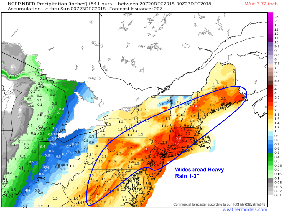
Because the band of rain will be oriented along a nearly N-S axis, with the motions of individual cells only slightly east of due north, a widespread heavy rainfall is expected with totals in the 1-3″ range for a wide swath of the Mid Atlantic and Northeast. The heaviest rain is likely to be from NNJ through SE NY, CT, and W MA. Terrain enhancements will drive totals towards 3″ along southern facing slopes of the Catskills, Adirondacks, and Whites as well. With such heavy rain and rapid snowmelt, river rises are expected to cause some minor flooding problems especially along the smaller rivers and streams. Watch for inundation of low lying areas typically susceptible in events like this one. Map via weathermodels.com.
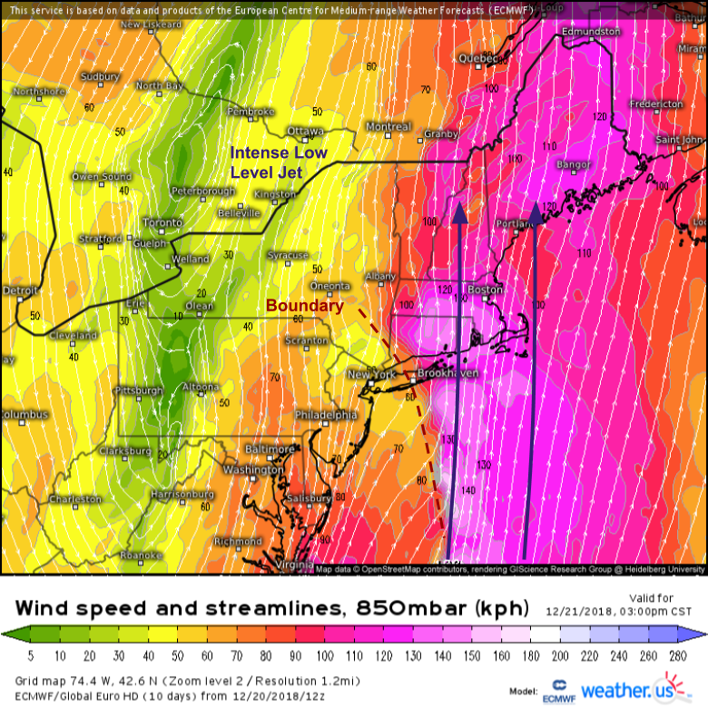
Another threat will come in the form of strong winds. As I mentioned before, a strong low level jet will be transporting warm moist air northward. The winds associated with that jet will be quite strong, well above hurricane force at 5,000 feet. Any time you have winds that strong that close to the surface, the threat for strong gusts comes into play. But a subtle feature around 2,500 feet may actually keep most of those gusts safely aloft. What’s that feature and why will it help prevent widespread wind damage?
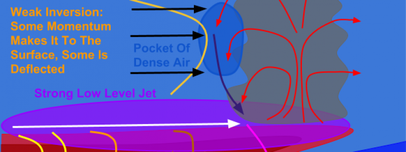
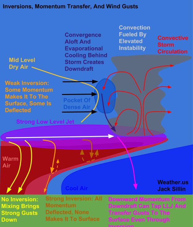
The feature is an inversion, which is a layer where the temperature increases with height (the opposite of the trend usually seen in the troposphere). The inversion blocks the downward transfer of wind gusts from the LLJ to the surface. How? The answer lies in the different density of warm and cold air. Warm air is less dense than cold air, and thus a parcel of warm air will “bounce off” a layer of cold air it is forced into, much as a drop of water bounces off high density concrete when it rains. The low level jet contains warm air, as we discussed in relation to the heavy rain threat. When that warm air tries to mix town to the surface, it gets blocked by the layer of low level dense air. The magnitude of the inversion of course determines just how much wind actually mixes down. A stronger inversion will block more wind than a weak inversion, and even with no inversion, you’ll have a hard time mixing down the full force of the winds aloft due to friction near the ground.
One spoiler to the protective effect of the inversion is convection (thunderstorms). If convection develops in the warm layer a few thousand feet up, it can help transfer momentum down to the ground even if there’s a fairly strong inversion present. How does that happen? On the back side of the convective cell, winds spreading out from the storm’s central updraft run into strong opposing winds in the mid levels. Those mid level winds transport dry air towards the storm. As the rain and snow from the convection evaporates in the dry air, latent heat is transferred from the air to the water molecules so that they can change from the lower energy solid/liquid phases to the higher energy gas phase. As the air loses energy, it cools. The effect of this process is a pocket of cold dense air just behind the convection. Eventually, this pocket is forced downwards by a combination of the converging winds and its higher density. On its way down, it picks up some downward momentum, and eventually encounters the low level jet. As the downdraft descends through the LLJ, it drags down some of the LLJ’s air parcels that have strong lateral momentum. If the downdraft is strong enough, and the inversion weak enough, that lateral momentum ends up translating into strong surface winds.
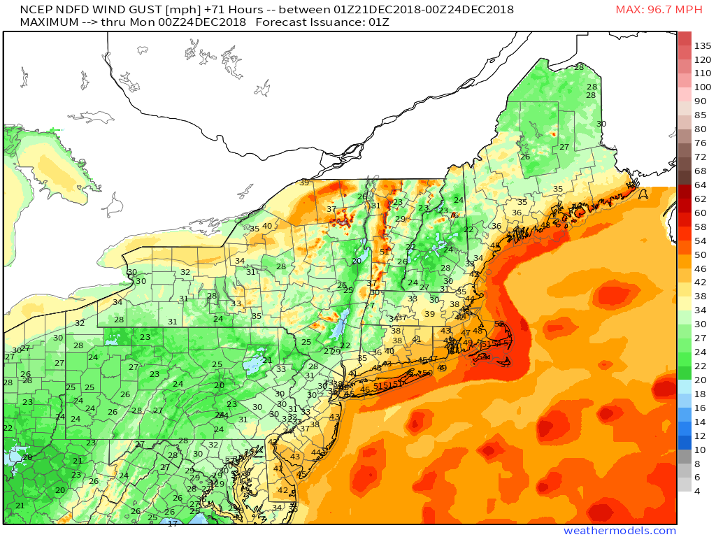
So how gusty will it get tomorrow? This map of NWS forecast max gusts gives a pretty good overview. The coasts of Long Island and Eastern New England will likely gust over 50 mph. Most of the coastal plain will see 30-40 mph gusts, while interior areas remain below 30 mph. The exception of course will be higher terrain areas which of course will get into the much stronger winds aloft even without any momentum transfer. Map via weathermodels.com.
Winds subside after a cold front crosses the region on Saturday.
-Jack


That was one of the best written weather pieces I ever read. That’s how a forecast should read to start to understand the mechanics. Thanks. I feel enlightened and stupid simultaneously. I may even be less of an ahole when i get a incorrect forecast.