Strong Storm System To Bring Heavy Snow And Severe Storms To Parts Of The Plains Tomorrow Into Saturday
Hello everyone!
The strong storm system currently bringing rain and mountain snow to California will be on the move tonight, arriving in the Plains by tomorrow. As the system emerges onto flatter ground, it will begin strengthening, bringing a variety of impacts from severe storms in NE TX/SE OK/AR/LA to heavy snow from Montana through Nebraska/South Dakota to Iowa. Steady rain will fall between the storms and snow, but no major impacts are expected from that segment of the storm.
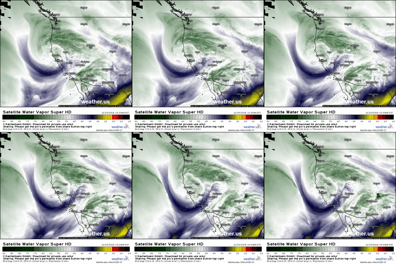
Here’s a look at animated WV satellite imagery of the storm currently moving through California. It’s easy to pick out the central swirl, just now approaching the San Francisco area. Moisture streaming north on the eastern side of the system is easily visible in the Southwestern states while rising motion responsible for heavy snow in the Rockies is visible west of Salt Lake City. Like the animated imagery? You can now make your own GIFs at weather.us with our extra features subscription. Check it out!
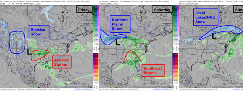
Here’s a look at how the system will generally progress through the weekend as it moves east. Friday we’ll be focusing on severe storms in the AR-LA-TX-OK region while heavy snow falls in the Rockies. On Saturday, we’ll see the severe threat shift east into AL-GA-FL while heavy snow cranks up in the Northern Plains. Finally, on Sunday, the system will exit with light wintry precipitation in the Great Lakes and far northern New England as thunderstorms move offshore. Maps via weathermodels.com.
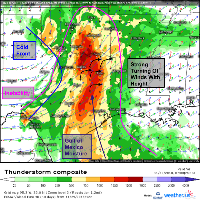
Starting with the first severe threat tomorrow, here’s a look at the setup, visualized by the ECMWF’s Thunderstorm Composite map. Orange/red shadings indicate CAPE values supportive of severe weather, while the wind vectors show strong winds aloft. Additionally, winds are rapidly strengthening and shifting direction with increasing height, indicating strong wind shear. A cold front trailing to the south of the developing storm will provide the trigger mechanism for storms, so all systems are a go for severe weather.
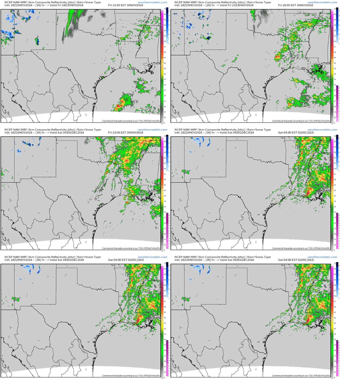
Here’s a look at simulated radar imagery for tomorrow evening as the storms develop. Storms are likely to be semi-discrete initially, with supercells expected due to the strong directional wind shear. Supercells will bring the threat for all modes of severe weather, including damaging winds, large hail, and tornadoes. As the front gets closer later in the evening, a more linear structure is likely to evolve with damaging winds becoming the primary threat as storms move towards the Mississippi River. GIF via weathermodels.com.
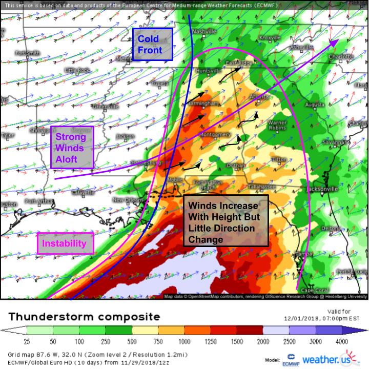
The severe threat will shift east on Saturday towards Alabama, Georgia, and Florida. Instability will again be marginal, but supportive enough for some strong storms. The cold front will once again act as the trigger mechanism for storms, while strong winds remain in place aloft. However, where winds in the severe area tomorrow will be both strengthening and turning with height, winds over the Southeast on Saturday will be unidirectional through the atmosphere, strengthening with height but not changing direction. As a result, there won’t be much in the way of rotational energy, thus the primary threat will be damaging winds.
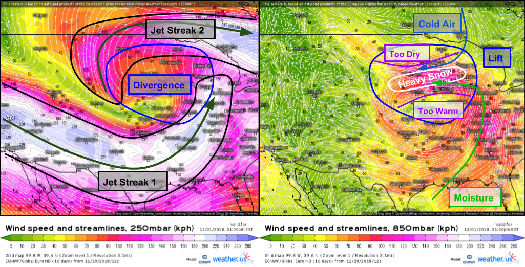
On the northern side of the storm, conditions will be favorable for heavy snow across parts of the Northern Plains. Wind forecasts from the ECMWF model in the upper levels (left) and low levels (right) show strong divergence aloft, with converging cold and moist airmasses near the surface. The result will be heavy snow in a narrow band stretching across northern Nebraska and southern South Dakota into NW Iowa and SW Minnesota. North of this zone, it will be cold enough to snow, and there will be rising motion from the divergence aloft, but there won’t be enough moisture. South of this zone, there will be enough moisture and lift, but temps won’t be cold enough, so rain is expected.
Here’s a look at roughly how much snow is expected from this system. Take this with a bit of a grain of salt as the forecast period this map is for (through Saturday evening) doesn’t encompass the entire storm. Thus, totals will be a bit higher than shown here, particularly over eastern parts of the area where heavy snow will fall Saturday night. The jackpot for this storm will span from NW IA through NE NE into southern/southwestern SD. Map via weathermodels.com.
Rain and snow moves east on Sunday, with light accumulations expected in the Great Lakes and mountains of Northern New England. Overall though, the impactful parts of this storm will be focused in the Plains and done by Saturday night/Sunday morning.
As always, find more forecast information specific not just to your region but also your town at weather.us.
-Jack
