Severe Storms Expected In Parts Of The Southeast Today
Hello everyone!
A strong upper level disturbance is ejecting out of the Rockies this morning, and will move swiftly east during the day today, arriving at the Mississippi River by sunset. As this system moves east, moisture will be flowing north from the Gulf of Mexico. The combination of some daytime heating, the moisture return from the Gulf of Mexico, and cooling temps aloft will result in developing instability this evening, which will coincide with the development of thunderstorms along the front itself. As these storms roll east, all modes of severe weather will be possible including large hail, damaging winds, and tornadoes.
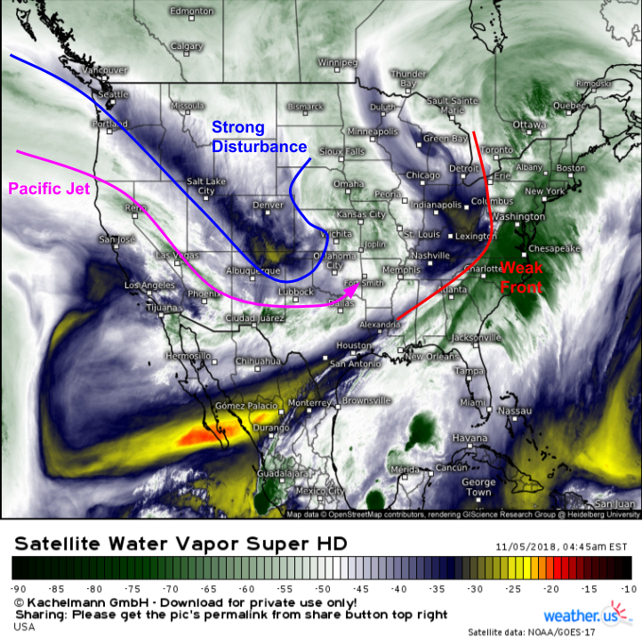
Here’s a look at WV satellite imagery this morning, which shows one system exiting over the East Coast and another digging SE through Colorado. On the southern flank of that Colorado disturbance is a very strong jet streak, extending from the open waters of the North Pacific all the way into Texas. That jet streak will play an important role in the upper level setup for today’s storms.
Here’s a look at the jet forecast for tonight, showing that strong Pacific jet dumping its energy over the southern Ohio Valley. The divergence aloft associated with the exit region of that jet is clearly evident by following the streamlines on the wind map above, and that divergence will be located right over the frontal boundary initiating the thunderstorms, resulting in a favorable environment for strong/severe thunderstorm development. Map via weathermodels.com.
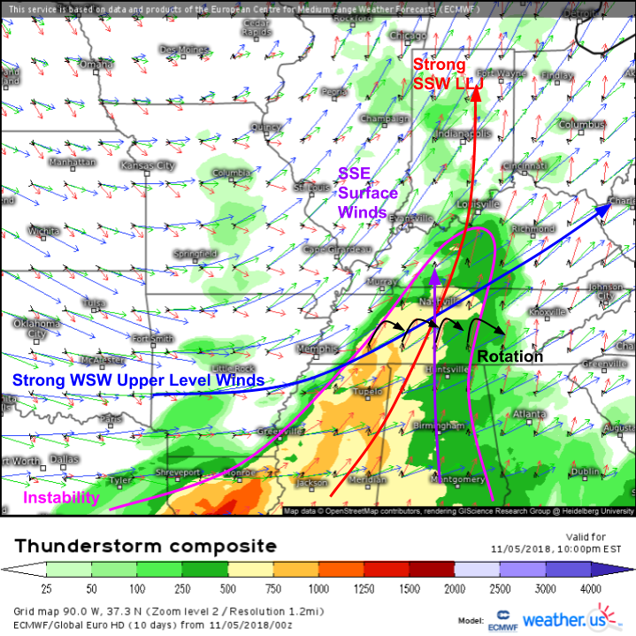
For a more thorough look at the severe storm environment, we’ll turn to the ECMWF’s thunderstorm composite map, shown here. The instability mentioned above is shown with the shading. The best instability will be located over Northern MS and Southern TN, but there will be just enough juice in the atmosphere farther north to support strong storms even up into Kentucky. The most impressive part of this setup will be the rotational energy packed into the atmosphere by winds that turn strongly with height. Modest SSE surface winds become strong from the SSW at 5,000 feet, and howling WSW winds are present in the mid levels. If discrete cells that aren’t part of a large squall line are able to form, they will be able to take advantage of this rotation to produce large hail and tornadoes in addition to damaging winds.
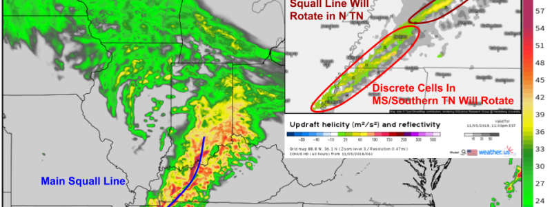
Here’s a look at simulated radar imagery for this evening, along with a measure of the rotational energy associated with individual storm cells (updraft helicity). This data supports the conclusion drawn from the thunderstorm composite map: any discrete storms that might be able to form in N MS/S TN will be rapidly rotating, and thus capable of producing tornadoes and large hail in addition to damaging winds. Farther north, the squall line will be the most efficient damaging wind producer, with the potential for brief tornadoes associated with mesovorticies along the line’s leading edge. Simulated radar map via weathermodels.com.
Any discrete cells present early in the night will merge into the line after midnight, and the line will slowly weaken as it approaches the Appalachians tonight.
Be sure to track today’s storms with GOES-East satellite imagery, HD radar imagery, and lightning analysis.
-Jack


